All Activity
- Past hour
-

E PA/NJ/DE Spring 2026 Obs/Discussion
JTA66 replied to PhiEaglesfan712's topic in Philadelphia Region
0.20" from the "main event", 0.40" from the leftover showers...go figure. -
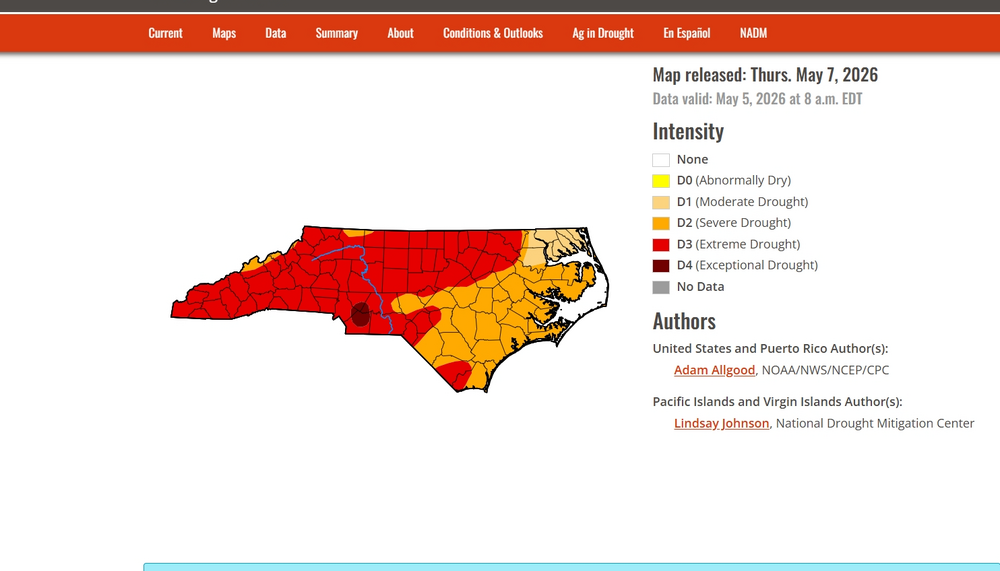
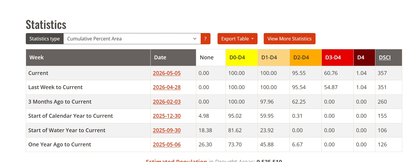
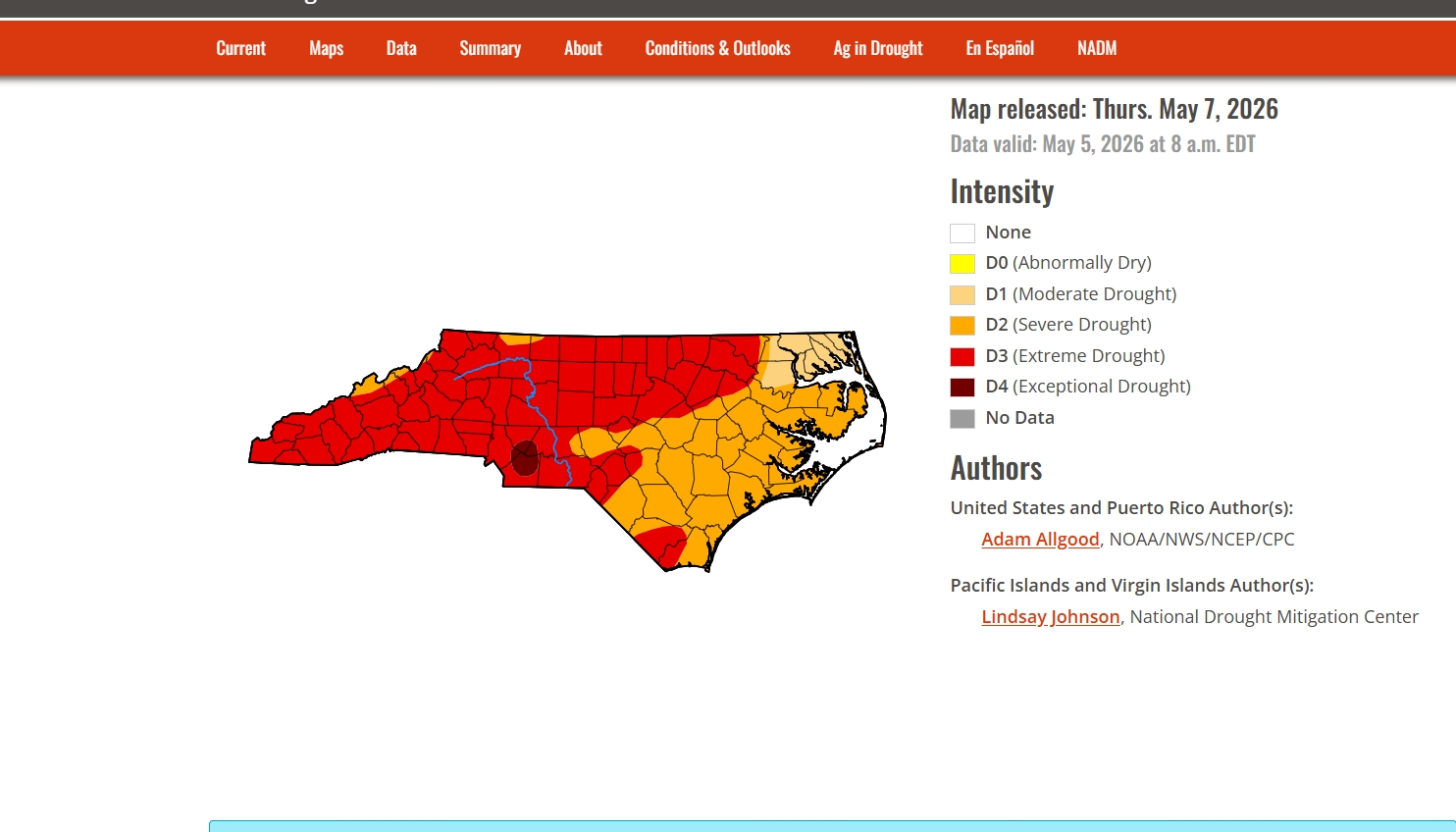
Although not for all areas, of course, I feel that next week’s map may show notable improvement (say at least one drought category) in portions of the SE. The N 1/2 of AL was the only area on the SE drought map that showed notable improvement.
-
I expect only minor changes to the drought map after this event. We still need a lot of rain for meaningful changes.
-
The fronts are moving through without stalling because of the strong NW and W flow
-

2026-2027 Strong/Super El Nino
snowman19 replied to Stormchaserchuck1's topic in Weather Forecasting and Discussion
The NMME joins the EURO, BOM, CFS -
Records: Highs: EWR: 94 (2000) NYC: 93 (2000) LGA: 93 (2000) JFK: 87 (2000) Lows: EWR: 38 (1996) N YC: 37 (1891) LGA: 40 (1970) JFK: 38 (1970) Historical: 1840 - A powerful tornado wrecked many boats at the Natchez Landing in Mississippi, then plowed through the city on the bluff. The tornado killed 317 persons, and caused a million dollars damage. The force of the storm caused houses to burst open. The tornado was the most deadly and destructive in early American history. (David Ludlum) 1857: The Washington Evening Star began publishing newspaper weather reports from the observations made by Joseph Henry's network of volunteer weather observers. (Ref. Wilson Wx. History) 1927: Two massive F5 tornadoes combined for a 95 mile path of destruction through Comanche, Barber, Kingman, Reno, and McPherson Counties in Kansas. The death toll was 10 and 300 were injured. Damage was set at $1.3 million dollars. The tornado’s path width reached two miles at one point. (Ref. Wilson Wx. History) 1930: Record Maximum temperature for Washington, DC for the date is 95 °F. 1964 - The temperature at White Mountain 2, located in California, dipped to 15 degrees below zero to set a record for May for the continental U.S. (The Weather Channel) 1970: Record Minimum temperature for Washington, DC for the date is 38 °F. 1987 - Thirty-one cities in the western U.S. reported record high temperatures for the date. Highs of 93 degrees at Portland OR and San Jose CA were the warmest of record for so early in the season. The high of 92 degrees at Quillayute WA was a record for the month of May. The temperature at Sacramento CA hit 105 degrees. (The National Weather Summary) 1988 - A powerful storm in the north central U.S. produced up to three feet of snow in the Bighorn Mountains of Wyoming and the mountains of south central Montana. Up to five inches of rain drenched central Montana in less than 24 hours, and flash flooding in Wyoming caused a million dollars damage. (Storm Data) (The National Weather Summary) 1989 - Thirty-two cities in the central and eastern U.S. reported record low temperatures for the date, and 24 hour snowfall totals of 7.2 inches at Buffalo NY and 10.7 inches at Rochester NY were records for the month of May. While northerly winds ushered unseasonably cold air into the eastern U.S., temperatures warmed rapidly in the Great Plains Region, reaching the 90s in Kansas. The temperature at Manhattan KS soared from a low of 30 degrees to a high of 88 degrees. (The National Weather Summary) (Storm Data) 1990 - Gale force winds lashed the northern and central Pacific coast. A wind gust of 52 mph at Eureka CA established a record for the month of May. Strong winds over northeastern Colorado, associated with a fast moving Pacific cold front, gusted to 63 mph at Peetz. Snow developed over the northwest mountains of Wyoming late in the day, and Yellowstone National Park was whitened with 6 to 14 inches. (The National Weather Summary) (Storm Data) 1992: A freak snowstorm in the North Carolina Mountains dumped 40 inches at Mt. Pisgah and 18 inches at Mt. Mitchell. 1995: Severe thunderstorms struck Aurora, CO. Hailed piled 4 to 5 inches deep in the vicinity of Quincy Reservoir in south Aurora. Lightning struck an Aurora Police Communications Tower causing significant malfunction to the primary system. Minor damage was sustained when lightning struck an apartment building. Hail up to 1.25 inches in diameter accumulated 6 inches deep in just 15 minutes. Many streets were closed for an hour or more due to flooding caused by heavy rain and melting hail. Some trees were stripped of their leaves. An F3 tornado cut a 34 mile path across Love and Carter Counties in south central Oklahoma, while on the ground for over an hour killing three people and doing over $100 million dollars in damages; $75 million in Ardmore alone. (Ref. Wilson Wx. History)
-
Keep in mind that the heavy rains covering much of the SE US since yesterday are of course not taken into account since these weekly maps are based on data being submitted no later than 8AM two days ago. Only the N 1/2 of AL showed improvement.
-
53 / 45 clouds splitting the area angled SW to NE - should clear out and make way for a nice albeit cooler next two days. 0.40 in the bucket. Clouds / showers Saturday another 0.25 - 0.50 rain and into Mothers Day and then on / off rain in between days next week. Overall cooler than normal through mid month before a moderation to a more persistent warmer pattern between the 17 - and beyond.
-

-
Not much change.
-
1.5-2" of rain for half the month isn't bad.. it's about average. pre-El Nino May's are nothing significant in the MA
-
Let's do it
-
Looking at official rainfall totals, a large portion of AL, TN, N and C GA, NW SC to CAE, and NC including CLT received ample to very heavy (flooding) rainfall since yesterday! Fantastic news regarding the drought and kudos to the Euro Weeklies to being on top of this potential for several weeks.——————This is just from FFC:MOST LOCATIONS HAVE SEE ANYWHERE FROM 0.5" TO 1.5" OF PRECIP WITH SOME ISOLATED LOCATIONS SEEING UPWARDS OF 2" TO 4". 1 LOCATION HAS SEEN 5.29" (CSG).
-
I really did! Lol. Last 18 mos in my area, its either a drought, or a flood. Up to 4.75" of rain now, more than 4 of it in 2 hours.
-
Dropped my scrip to Aguacero and switched to WeatherFront. Really liking WF and it’s products .
-

2026 Spring/Summer Mountain Thread
franklin NCwx replied to Buckethead's topic in Southeastern States
Closing in on 3 inches as its starting to wind down here -
It hit a trailer park unfortunately. Likely EF3 damage outside of the park .
-
I decided against it as trees made it nearly impossible to navigate and the back roads all had a northbound component with little east or west options. Besides, the storm was HP (that has not stopped me before) but in the location it tracked there was no way of even getting a good view without putting myself in a very bad position. I’m also glad I did not chase because I-55 had to be shutdown in both directions as trees were blocking the road. This is also why I am so hesitant about chasing south of I-20. You kinda of make your decision with little to no other option of getting out once you are down there. To help me make go vs no go decisions, I use Google Maps and the street view to help get a better understanding of the road network or even possible intersections before chasing in my chase target areas. I tend to find it more successful when I do study my chase targets as it allows me to have a better understanding of what I might come across instead of going in blind. Even when I am thinking about going into the Delta, I like to have a rough idea of what roads will lead back to a major highway or interstate for my commute back or in case of an escape route. I also tend to find places where I can pull over at where I can get back on the road safely and with little trouble. I may miss more opportunities to chase when doing this, like last night, but I also know I much rather be comfortable and safe than unsure and feeling lost. My end goal of chasing is to photograph and document storms. I am not here to be the next Reed or anything like that. This is just a hobby for me.
-
1.25” here .
-
The thing is, the warmer pre-strong/super el nino summers in the Eastern US (1991 and 2015) were preceded by borderline warm neutral/weak el nino winters. We did not have that this year, like in 1972, 1982, 1986, 1997, 2009, and 2023. All of those years had cooler summers.
-
I thought you said it was never going to rain again. Lol.
-
Even when we didn't have NW flow it was dry as a mofo and basically at 90 degrees... We need a stall front to just sit across the area and produce rainfall.
-

2026-2027 Strong/Super El Nino
PhiEaglesfan712 replied to Stormchaserchuck1's topic in Weather Forecasting and Discussion
91-92 would have probably had a big global temperature jump if not for Pinatubo. It was the 3rd robust el nino in 10 years, and coming off the heels of a temperature jump from the 86-88 el nino. But my guess is that if Pinatubo never happens, 97-98 still has a temperature jump, but not as drastic. 97-98 not only had the super el nino, but the exiting of a cooling period from a major volcano to enhance its temperature jump. -

Central PA Spring 2026 Discussion/Obs Thread
Mount Joy Snowman replied to Voyager's topic in Upstate New York/Pennsylvania
This probably amuses me more than it should.......low of 46 with .46" of rain. It's gonna be a good day ha. -
Welcome to the west side of the state


.thumb.jpg.049f4a7f726ada07e8cd30bd17e713cb.jpg)


