All Activity
- Past hour
-

July 2025 Obs/Disco ... possible historic month for heat
metagraphica replied to Typhoon Tip's topic in New England
80/55 CoC. Gonna need a sweatshirt to watch the fireworks tonight. Cool and dry. -
the dryness of the air reminds one of autumn, of the shortening days, the return to school. it’s independence day but might as well be 6:30 pm on football sunday. soon the ticking of the 60 Minutes clock will end my weekend, and there’s still so much homework i have been ignoring
-

July 2025 Discussion-OBS - seasonable summer variability
Brian5671 replied to wdrag's topic in New York City Metro
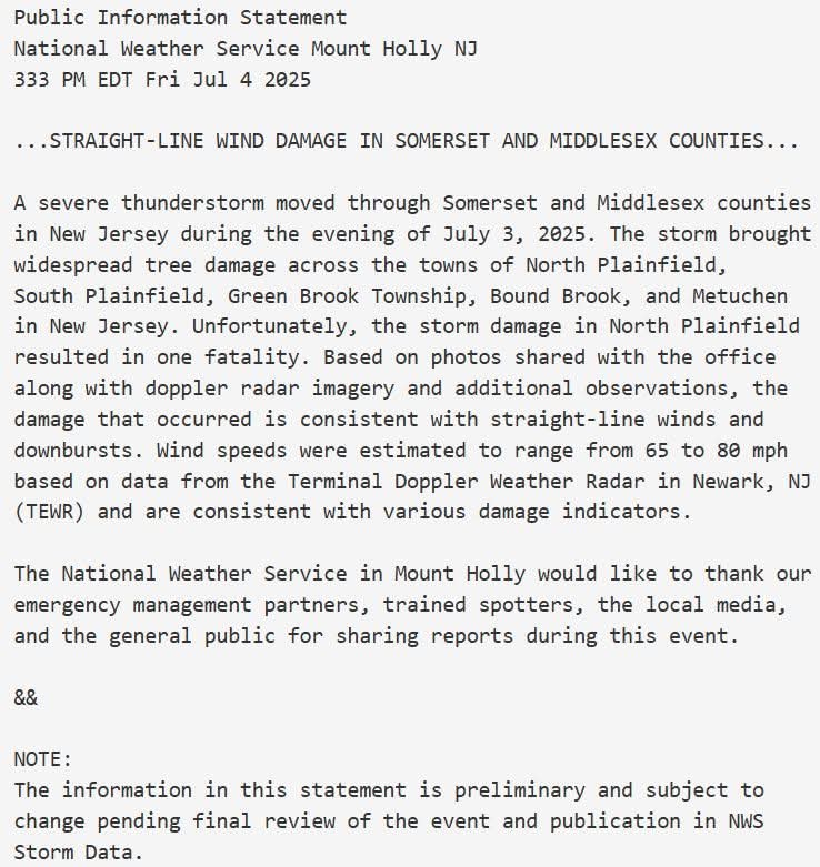
storm hit north of me-missed us by 3-4 miles-tree damage is intense (Trumbull, CT) -
A Tropical Storm Watch has been issued from Edisto Beach, South Carolina to Little River Inlet, South Carolina. Tropical Depression Three Discussion Number 1 NWS National Hurricane Center Miami FL AL032025 500 PM EDT Fri Jul 04 2025 The wind circulation associated with the low pressure area east of the coast of north Florida has become stronger, with aircraft and scatterometer data indicating a well-defined circulation with maximum winds near 30 kt and a radius of maximum wind of about 80-90 n mi. The system has also developed persistent convection east and southeast of the center. Based on these developments, advisories are being started on Tropical Depression Three. The cyclone is currently being affected by 20-25 kt of southwesterly shear caused by a mid- to upper-level trough not far to the west. The initial motion is uncertain due to some reformation of the center, with the best estimate of 360/2 kt. During the next 24 h, the cyclone should move slowly north-northwestward on the northeast side of a developing mid- to upper-level low over the northeastern Gulf. After that time, the system should be steered northward with a gradual increase in forward speed. This motion should bring the center near or over the coast of South Carolina Sunday morning. A generally northward motion should then continue until the system dissipates over land. While the guidance generally agrees with this scenario, there is considerable spread in both the forecast direction and speed, with the HWRF being a notable right outlier. The forecast track is in best agreement with the GFS and the HCCA corrected consensus model. The current shear is expected to diminish on Saturday as the upper-level trough moves westward away from the cyclone and the upper-level winds become southerly. However, the upper-level winds are forecast to become convergent, which may limit the amount of convection the system produces. Most of the guidance shows some development as the system approaches the coast, so the intensity forecast calls for modest strengthening to a tropical storm before the cyclone makes landfall. This forecast is a little below the intensity consensus.

-

July 2025 Obs/Disco ... possible historic month for heat
kdxken replied to Typhoon Tip's topic in New England
-
couldn't even be a tropical depression LOL
-
someone change the thread title NHC will initiate advisories on Tropical Depression Three, located in the Atlantic Ocean offshore of the southeastern United States, at 500 PM EDT (2100 UTC).
-

July 2025 Discussion-OBS - seasonable summer variability
donsutherland1 replied to wdrag's topic in New York City Metro
Tomorrow will be warm with highs reaching the middle 80s across the New York City area. It will turn hotter on Sunday and the heat could persist through Tuesday. Highs will top out in the upper 80s to around 90° in New York City. New Jersey's hot spots will likely reach the lower and perhaps middle 90s. The ENSO Region 1+2 anomaly was +1.0°C and the Region 3.4 anomaly was 0.2°C for the week centered around June 18. For the past six weeks, the ENSO Region 1+2 anomaly has averaged +0.47°C and the ENSO Region 3.4 anomaly has averaged -0.03°C. Neutral ENSO conditions will likely continue through at least late summer. The SOI was +3.57 yesterday. The preliminary Arctic Oscillation (AO) was +1.175 today. -
460 WTNT33 KNHC 042034 TCPAT3 BULLETIN Tropical Depression Three Advisory Number 1 NWS National Hurricane Center Miami FL AL032025 500 PM EDT Fri Jul 04 2025 ...TROPICAL DEPRESSION FORMS OFF OF THE SOUTHEAST U.S. COAST... ...TROPICAL STORM WATCH ISSUED FOR PORTIONS OF SOUTH CAROLINA... SUMMARY OF 500 PM EDT...2100 UTC...INFORMATION ---------------------------------------------- LOCATION...30.8N 79.0W ABOUT 150 MI...240 KM SSE OF CHARLESTON SOUTH CAROLINA ABOUT 245 MI...395 KM SSW OF WILMINGTON NORTH CAROLINA MAXIMUM SUSTAINED WINDS...35 MPH...55 KM/H PRESENT MOVEMENT...N OR 360 DEGREES AT 2 MPH...4 KM/H MINIMUM CENTRAL PRESSURE...1012 MB...29.89 INCHES WATCHES AND WARNINGS -------------------- CHANGES WITH THIS ADVISORY: A Tropical Storm Watch has been issued from Edisto Beach, South Carolina to Little River Inlet, South Carolina. SUMMARY OF WATCHES AND WARNINGS IN EFFECT: A Tropical Storm Watch is in effect for... * Edisto Beach to Little River Inlet A Tropical Storm Watch means that tropical storm conditions are possible within the watch area, generally within 48 hours. Interests elsewhere along the southeast coast of the United States should monitor the progress of this system. Additional warnings and watches will likely be required for portions of this area later tonight and Saturday. For storm information specific to your area, including possible inland watches and warnings, please monitor products issued by your local National Weather Service forecast office. DISCUSSION AND OUTLOOK ---------------------- At 500 PM EDT (2100 UTC), the center of Tropical Depression Three was located near latitude 30.8 North, longitude 79.0 West. The depression is moving toward the north near 2 mph (4 km/h). A slow motion toward the north-northwest is expected through Saturday, followed by a motion toward the north Saturday night and Sunday. On the forecast track, the center of the depression is expected to move near or over the coast of South Carolina Sunday morning. Reports from an Air Force Reserve Hurricane Hunter data indicate that maximum sustained winds are near 35 mph (55 km/h) with higher gusts. Gradual strengthening is expected, and the system is forecast to become a tropical storm on Saturday. The minimum central pressure estimated from Air Force Reserve Hurricane Hunter aircraft data is 1012 mb (29.89 inches). HAZARDS AFFECTING LAND ---------------------- Key messages for Tropical Depression Three can be found in the Tropical Cyclone Discussion under AWIPS header MIATCDAT3 and WMO header WTNT43 KNHC. WIND: Tropical storm conditions are possible in the watch area beginning late Saturday or early Sunday. RAINFALL: Tropical Depression Three is expected to produce heavy rainfall across portions of the coastal plain of the Carolinas Saturday through Monday. Storm total rainfall of 2 to 4 inches, with local amounts to 6 inches, is expected. This would result in an elevated risk for flash flooding. For a complete depiction of forecast rainfall and flash flooding associated with Tropical Depression Three, please see the National Weather Service Storm Total Rainfall Graphic, available at hurricanes.gov/graphics_at3.shtml?rainqpf STORM SURGE: A storm surge of 1 to 2 ft above ground level could occur along the coast in the tropical storm watch area in areas of onshore flow. SURF: The depression is expected to bring rough surf and rip currents to much of the Carolina coastline during the next couple of days. NEXT ADVISORY ------------- Next intermediate advisory at 800 PM EDT. Next complete advisory at 1100 PM EDT. $$ Forecaster Beven
-
Currently 82 after a high of 84. Was a tad more humid this morning but the dews mixed out. So nice out right now.
- Today
-
They’re going with a TD rather than STD as of the 5 PM/initial advisory: NHC will initiate advisories on Tropical Depression Three, located in the Atlantic Ocean offshore of the southeastern United States, at 500 PM EDT (2100 UTC).
-

2025-2026 ENSO
Stormchaserchuck1 replied to 40/70 Benchmark's topic in Weather Forecasting and Discussion
SST feedback doesn't make sense to me. Seems like kind of a simple answer. The tropics have recently shown a good SST correlation though with tropical systems. It works in the tropics, but not really in the upper latitudes. -
Satellite imagery is a bit deceiving as the MLC is well east of surface circulation and surface center is diffuse. Will be interesting what NHC goes with at 5, but it’s not far off from a name. IMO this very likely gets named and areas east of landfall have a nasty weekend
-

July 2025 Obs/Disco ... possible historic month for heat
BrianW replied to Typhoon Tip's topic in New England

-
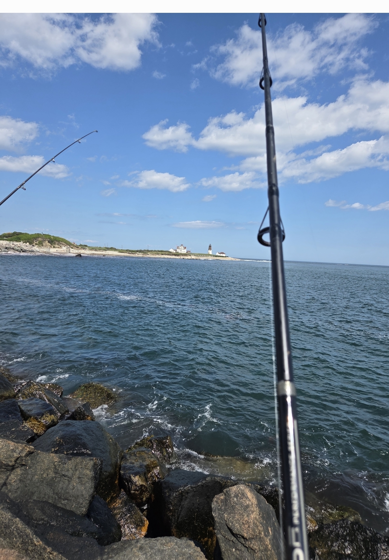
July 2025 Obs/Disco ... possible historic month for heat
BrianW replied to Typhoon Tip's topic in New England
What a day out on Pt Judith fishing with my Nephew. Low 70's and a nice sea breeze.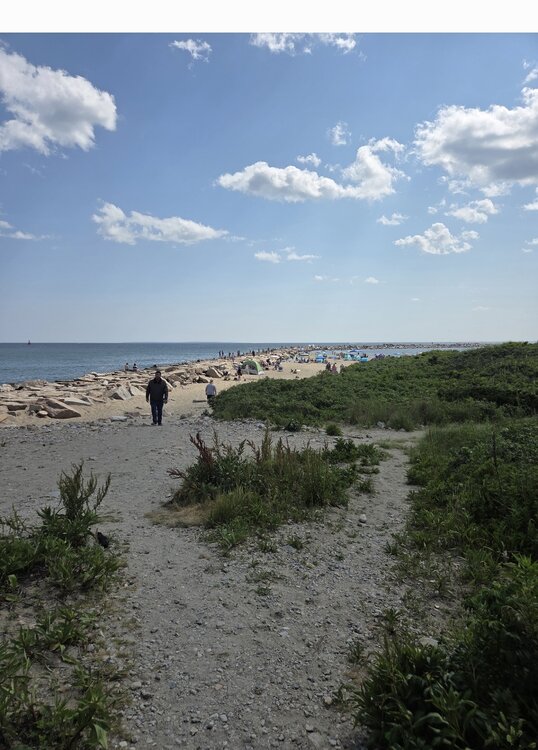
-

July 2025 Discussion-OBS - seasonable summer variability
Stormlover74 replied to wdrag's topic in New York City Metro
-
I just saw this, which suggests the NHC may be going with a 30 knot subtropical depression perhaps due to the center being too broad for TD status: AL, 92, 2025070418, , BEST, 0, 309N, 790W, 30, 1012, SD Also, note the 79.0W longitude, which suggests it’s a little E of the 79.5W longitude that the LLC was earlier supposedly near.
-

July 2025 Discussion-OBS - seasonable summer variability
steve392 replied to wdrag's topic in New York City Metro
79 degree's out. Gorgeous. Only been outside once at work and that was to check on the cook for the bbq we're having. Got bbq hook up outside to natural gas when we built this place. Lots of food. Ready for nap. -

E PA/NJ/DE Summer 2025 Obs/Discussion
mattinpa replied to Hurricane Agnes's topic in Philadelphia Region
Exactly - not much middle ground. -
We have been seeing these lulls in recent years when the subtropical warming has increased faster than the tropics. But often by later in the season SST anomalies between the tropics and subtropics balance out. So the tropics sit quietly gaining record amounts of heat through the season with suppressed convection. But when the hurricanes do finally form later on, we get these rapidly intensifying hurricanes becoming majors right before landfall on the Gulf Coast. Different from the old days when most hurricanes seemed to weaken right before landfalling.
-
86/56. Doesn’t get much better in July
-
Looks too broad based on what we have right now, but they need to sample that north side.
-

July 2025 Discussion-OBS - seasonable summer variability
bluewave replied to wdrag's topic in New York City Metro
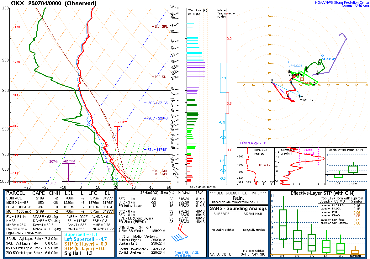
Severe storms usually overperform when we have steep lapse rates and such unstable soundings.
-
2025-2026 ENSO
Stormchaserchuck1 replied to 40/70 Benchmark's topic in Weather Forecasting and Discussion
Why are the mid-latitudes warming though? It might just be a pattern that fluxes up and down, with general global warming. -

July 2025 Discussion-OBS - seasonable summer variability
Dark Star replied to wdrag's topic in New York City Metro
I actually sat outside all morning, and occasionally a few times this afternoon. Unbelievable!