All Activity
- Past hour
-
lol quite true. you can have mid March OR you can have late June!
-

Texas 2026 Discussion/Observations
Stx_Thunder replied to Stx_Thunder's topic in Central/Western States
https://www.americanwx.com/bb/topic/62492-texas-2026-discussionobservations/?do=findComment&comment=8079563 5" measured hail was reported back on April 29 from a (fully discrete) HP supercell not far out west of SAT. Hailstones that big can definitely kill if struck on the head. Especially because they're much heavier, and obviously fall faster than smaller ones. Typically >100 mph. Hail stones in the southwestern region do tend to be the largest in this state, as I've seen over the years. The supercells that popped up there in SWTX that evening of April 29 easily had tops of 60 Kft on ET radar imagery. Which easily contributes to bigger hail production in them. Although HP supercell tops >50 (and over the neighboring Mexican terrain), are quite common around there in the later spring. And in STX. - Today
-
It's autumn in reverse, it's amazing!
-

2026-2027 Strong/Super El Nino
snowman19 replied to Stormchaserchuck1's topic in Weather Forecasting and Discussion
We disagree but that’s what this forum is for…sharing different opinions. I think this El Nino’s RONI breaks the all time RONI record from 1982-83 and also ends up breaking the record traditional ONI since 1950 -
48 at 9:40 on May 11… pretty chilly!
-
nothing unless gulf stream stops moving..
-
Mount Holly's latest AFD KEY MESSAGE 3...Widespread rain with potentially a few thunderstorms moves in for the afternoon hours on Wednesday, continuing into Thursday morning. The upper-level pattern is forecast to become rather amplified through this week. A strong upper-level trough axis shifts to our east Tuesday as high pressure will also be shifting offshore. Another upper-level trough then moves over the Eastern US Wednesday into Thursday before lifting out Friday into Saturday. Guidance seems to be trending toward the earlier ECMWF`s idea that the incoming trough will close off either over our area or just off to the east. The timing and location of where the cutoff occurs will determine when things dry out. If the trough cuts off over our area, showers could linger into Thursday. If it cuts off just to the east, showers should move out by Thursday, giving way to a nice weekend (more on that in Key Message 3). Regardless of how this transpires, a round of widespread rain is expected with as the incoming trough and cold front arrive. As the aforementioned upper-level trough moves into the region Wednesday, low-level warm air advection will increase ahead of it as the low to mid level flow also increases. This will result in an increase in forcing for ascent, and some instability should develop ahead of the main forcing. A warm front should also lift across our area Wednesday with some ascent associated with it. As a result, showers should increase Wednesday from west to east, especially in the afternoon with forcing peaking Wednesday night as the cold front arrives. The amount of destabilization is more uncertain, however guidance does show some instability which should be enough to support at least a few thunderstorms. The intensity of any thunderstorms however will depend on the magnitude of the instability and shear. However, guidance this morning does not show much in terms of instability, with shear looking rather meager as well. This would result in a low to zero severe threat, with better kinematics well off to our west. The main forcing should shift to our east and northeast Thursday with the bulk of the showers ending. However, if the closed low scenario ends up happening, then the core of the cold air aloft with this slides overhead and this could result in additional shower development on Thursday before the system departs our region. Rainfall amounts are trending to be right around a half inch or so.
-
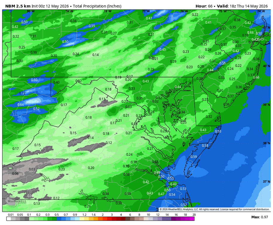
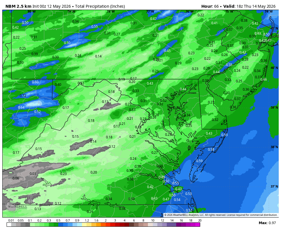
WB 0Z NBM for midweek.
-
Below normal temps in the gulf stream? I wonder what that will do to the weather in Europe.
-
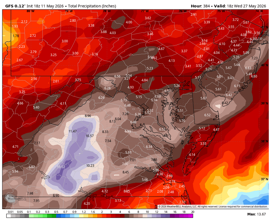
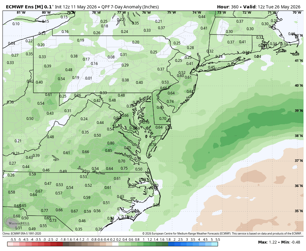
WB 12Z EPS supports a wetter forecast for May 20-26th period.

-
-
Your lawn will like it!
-
SPC storm reports says 4.50" near Hamilton! I wonder how many injuries there are per year from 2.75" plus hail. I know there are essentially no fatalities from hail.
-
Much of this week will see temperatures top out in the lower and middle 60s. Additional showers are possible on Thursday as a warm front moves northward. There remains a risk that the front could stall for a time. Friday could see temperatures return to the 70° or above should the front clear the region. It will turn warmer during the weekend. Parts of the area could reach or exceed 80° on Saturday and especially Sunday. In the long-range, there has been a shift in the guidance toward a near or somewhat warmer than normal second half of May. The probability of a warmer than normal second half of May has increased. The ENSO Region 1+2 anomaly was +1.6°C and the Region 3.4 anomaly was +0.9°C for the week centered around May 6. For the past six weeks, the ENSO Region 1+2 anomaly has averaged +1.50°C and the ENSO Region 3.4 anomaly has averaged +0.55°C. El Niño conditions are rapidly developing and will likely be in place in the next few weeks. The SOI was -9.25 today. The preliminary Arctic Oscillation (AO) was +0.922 today. Based on sensitivity analysis applied to the latest guidance, there is an implied near 50% probability that New York City will have a cooler than normal May (1991-2020 normal). May will likely finish with a mean temperature near 63.2° (near normal). Supplemental Information: The projected mean would be 0.7° above the 1981-2010 normal monthly value.
-
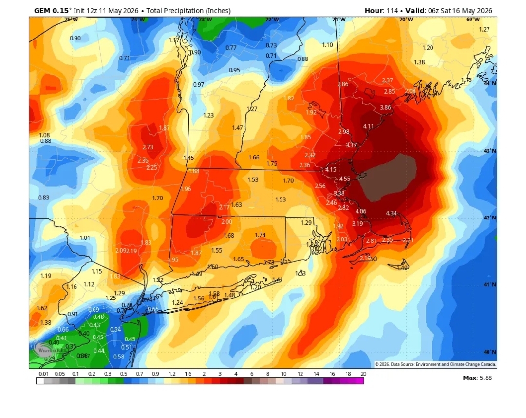
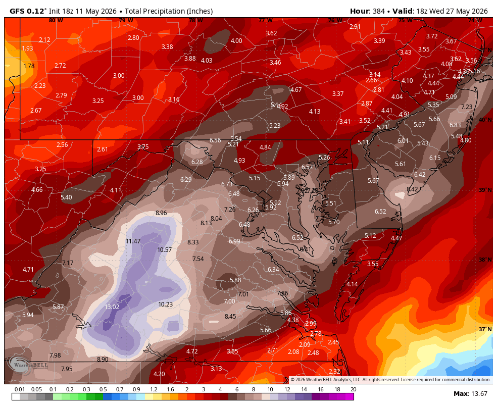
WB 18Z GFS went berserk with rain....maybe early but hopefully a sign of things to come with the El Niño.
-
18z euro is over 2” here.
-
App has about a half inch in total .
-
Frost tonight and 90 by Sunday. The bimodal distribution continues
-
Whatever your app has
-
What's your forecast?
-
I’m assuming you’re as uninformed as most of your tweet and wx app posts and missed the Euro part
-
Looking to get cold up your way tonight and tomorrow night. Stick with the couch.
-
Killer sunset out there
- Yesterday
-
Accordion man won’t like that map
-
Yeah, Eastern Mass barely gets over 4"


.thumb.gif.f92b16c631a1d15d405ed77b33f0710d.gif)