All Activity
- Past hour
-
Both of you are ridiculous lol. Noticed we have been more focused on Worcester temps suddenly as BOS goes 90F. Love the game .
-
Fortunately we all got home before all the flash flooding in Hamilton County. Usual trouble spots got bad, and few new problem areas showed up. So far it's the second highest daily rainfall at KCHA. First was around Labor Day 2011 but that was over a longer period all day. Today was pretty much all in a few hours. Others in the Chattanooga area and also Bradley County, please check in when you have a chance. Today was intense.
-
The worst flash flooding we have had in years is underway right now. 4-6” of rain hit right at rush hour. Cars are floating on I-24 in East Ridge. 5.64” in my gauge.
-
-
I just posted what I’m looking at, haha. Even explained the times and valid dates. Took 3 minutes. You know I was going to go look up if what you were saying was true. I just like living in reality. I’ve been on the torch train, now the models are a bit cooler next week. Show us with model data how the models have been trending warmer over the past cycle runs… I’m curious.
- Yesterday
-
I guess it's time to face reality and accept that there is a distinct possibility that I will not see a New England hurricane in my lifetime. I wasn't even alive for Bob. The record for longest drought between hurricanes I think is 42 years between 1896 and 1938. If we don't see one by 2033 we will break the record. Have to travel if I ever want to see one I guess.
-
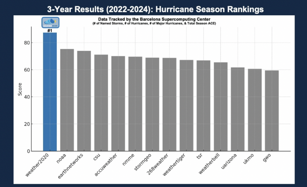
Keep in mind that Gary Lezak is pushing his own product, weather2020 with these predictions. He wants page clicks, and to get people to subscribe to his product.
-
Yes, don't be too sold on a recurve yet.
-
-
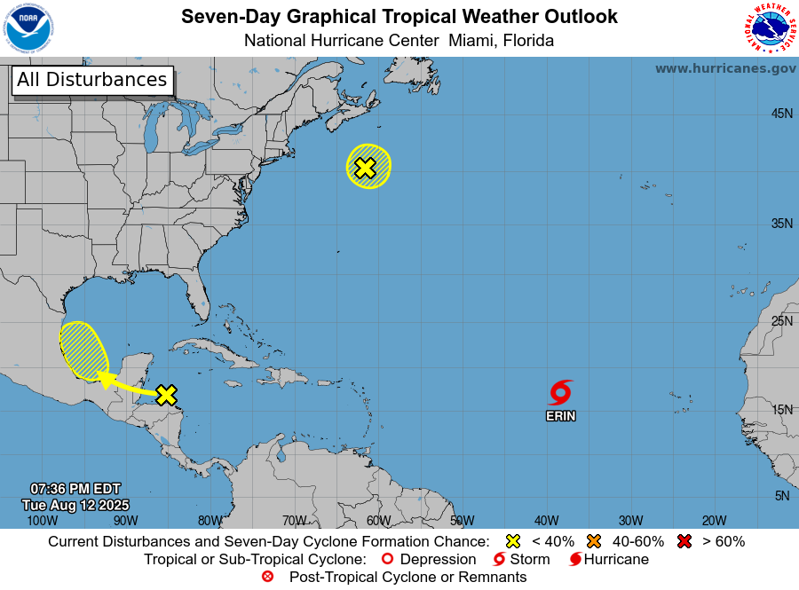
1. Southwestern Gulf: A tropical wave over the northwestern Caribbean Sea is producing disorganized showers and thunderstorms extending across eastern Honduras, northeastern Nicaragua and adjacent marine areas. This system is forecast to move west-northwestward and cross the Yucatan Peninsula on Wednesday with no significant increase in organization. Some development of this system is possible after it emerges across the southwestern Gulf beginning on Thursday while the system moves to the west-northwest or northwest at 10 to 15 mph. * Formation chance through 48 hours...low...10 percent. * Formation chance through 7 days...low...20 percent.
-
Thank you for the clarity. There's a lot of kooks on here.
-
No multi day heat wave here. Hasn't even hit 90 in Worcester this week. Providence was lucky to get a one day heatwave. The sustained low dew points have been record setting however! Seriously how often do you get heat indexes less than the actual temperature? Something to tell your grandchildren about ...
-
No idea what you’re looking at . Did More de garbage get ahold of your phone?
-
 Meteor shower viewing should be decent tonight
 -
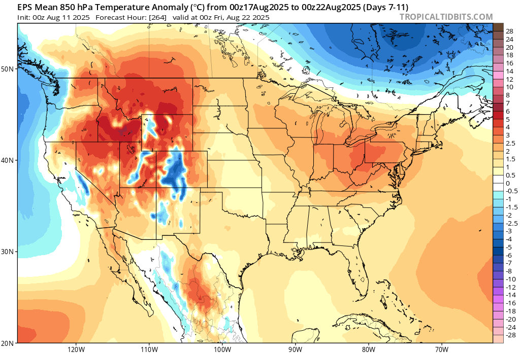
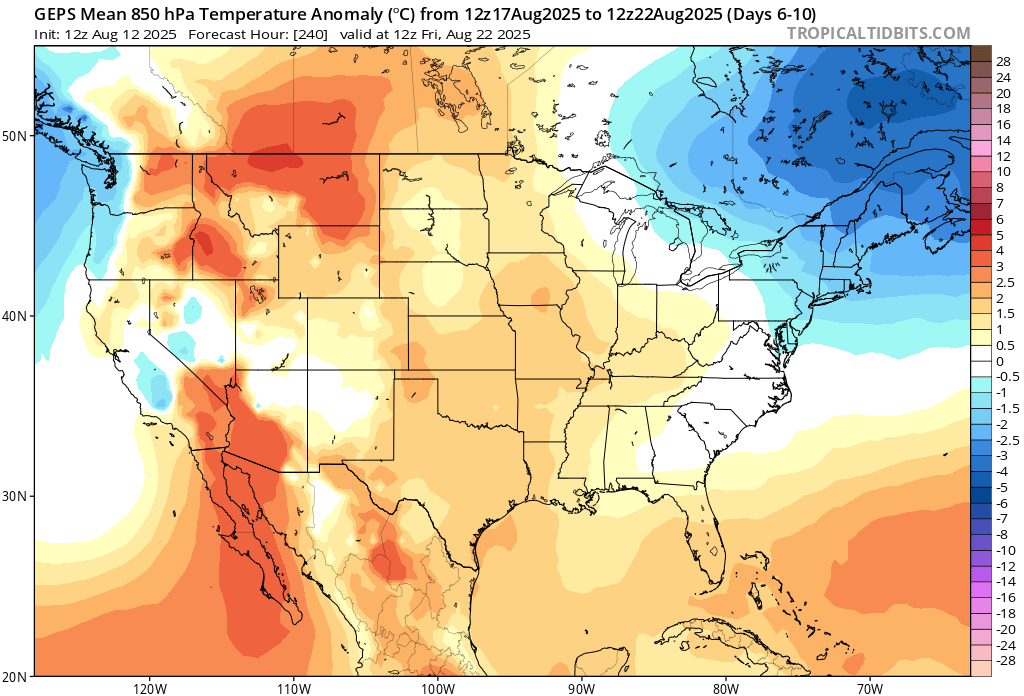
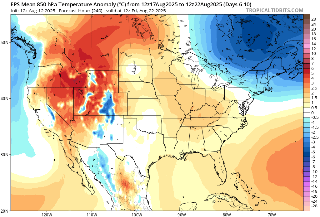
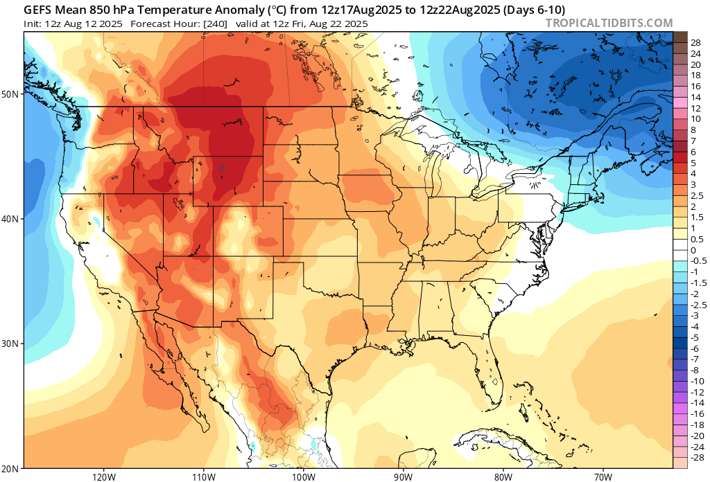
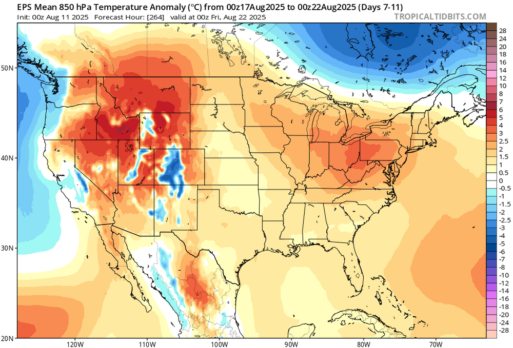
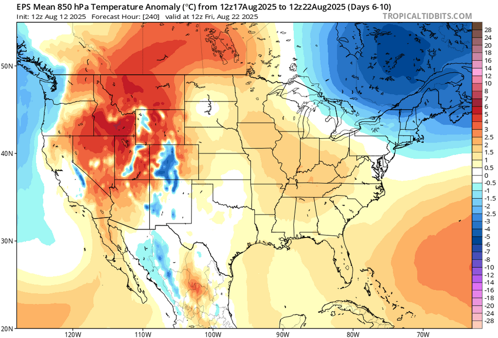
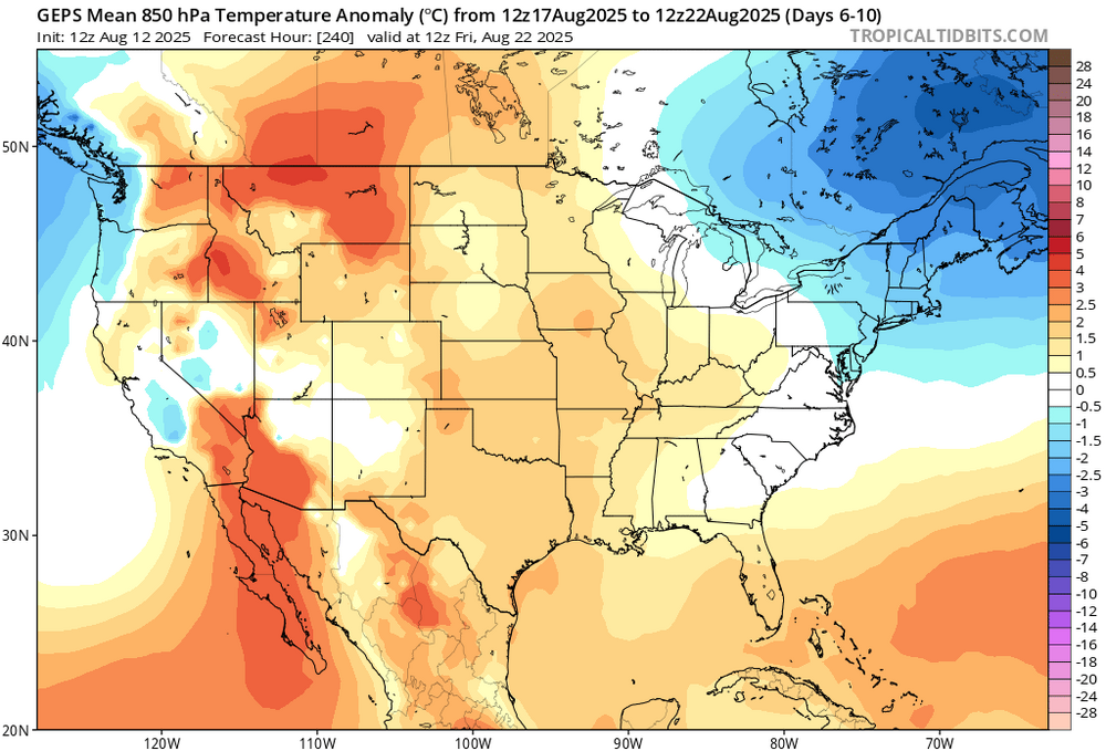
Huh. You mean like this? 00z Monday (36 hrs ago) Day 7-11. Valid 00z/Aug 22 Today 12z run. Day 6-10. Move solidly to deeper trough in past 36 hours.
-
Compare that to earlier runs. Erin pumping
-
Yup, it’s clearly visible on all three major ensembles. All the day 6-10 means at 850mb.


-
smoked out days with 80-90F highs and 50F lows, sounds like what everyone wants. Chamber of Commerce were most certainly out and about gathering pictures and content when you can't see over the next hill. Taste the Coc
-
We are in the midst of a very warn to hot next 30-60 days in general . Erin is already pimping the ridge on long range stuff and you can see that reflected today with higher numbers next week and beyond. Canes bring their environment ti higher latitudes .. even indirectly
-
A middle ground does not exist in that radical and extreme mind.
-
Hope all is well Don
-
Congrats NNE, pretty run of the mill heat around here. Low 90s and dews near 60. Looking forward to some higher dews tomorrow.
-

2025 Spring/Summer Mountain Thread
Maggie Valley Steve replied to Maggie Valley Steve's topic in Southeastern States
Another wet day in the Valley where my high today was 74. Looks like a potential flooding issue overnight, particularly for the SW Mountains. Below normal highs looks likely until at least the end of the week, I not so sure a return to above normal will return anytime soon. This is the second week of busted forecasts by GSP. -
 Burlington made it to 98F. Second latest date in the calendar year to reach 98F.
 -
He reminds me of a light switch, It’s either on or off.