All Activity
- Past hour
-
We don't get deep, wide precipitation bands anymore. Looking at radar I would expect that look in the tropics or out in Hawaii. Lots of individual cells that pop up / disappear quickly. Not sure what is the reason behind it.
-

2025 Atlantic Hurricane Season
Stormchaserchuck1 replied to BarryStantonGBP's topic in Tropical Headquarters
^Very interesting! The NAO looks to be pretty positive for the next 7 days, which is anti-Atlantic tripole. Remember, May is kind of a sensitive month for south-central Atlantic warming and the following season. -
Grantsville, Md 9:30pm, elevation 2,820’ — A solid steady rain past 2 hours and temp now down to 55 after hi temp 66; periods of sun/clouds/sun all day before evening showers moved in.
-
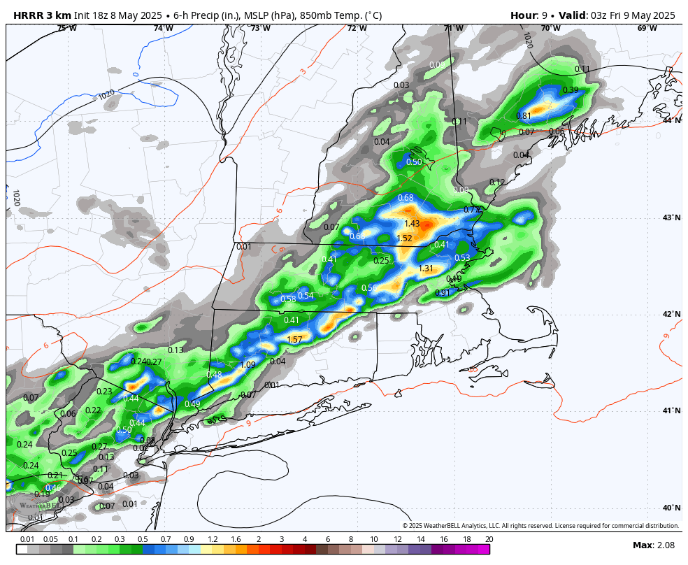
To be fair, convective events are tough. Even when occurring, basin averages can be much less than the spot/point samples of a singular location. Depends on how big a basin though, ha. HRRR from 18z seemed to sense something was going to happen. Actual results vary, but it knew some localized water was coming.

-
.35 here so far since 5:30pm.
-
Lol. She. But yeah. Bulldozers etc called in to fix it.
-
Traveled the Pike between Sturbridge and Springfield in the last hour and it was absolutely dumping in places
-
I'm up to 0.80" for the day as I type. 4.64" since last Friday night.
-

2025 Spring/Summer Mountain Thread
Met1985 replied to Maggie Valley Steve's topic in Southeastern States
Pea size hail Sent from my SM-G998U using Tapatalk
-
CT river expected to get close to mod flood stage now
-
2025-2026 ENSO
Stormchaserchuck1 replied to 40/70 Benchmark's topic in Weather Forecasting and Discussion
Pretty nice Aleutian High pattern getting going at Day 13+ on the GEFS. Let's see what happens, that is associated with possibly some cooling in the ENSO subsurface, and a short term trend to more -PDO. Could pop a nice ridge in the Midwest, too. -

E PA/NJ/DE Spring 2025 Obs/Discussion
LVLion77 replied to PhiEaglesfan712's topic in Philadelphia Region
59f - Moderate rain -0.16” so far. It will be interesting to see how the precipitation continues to develop along this frontal boundary. . -
2025 Spring/Summer Mountain Thread
Met1985 replied to Maggie Valley Steve's topic in Southeastern States
Getting pea size hail now -
we pray the 18z GFS has a clue.. the next 2 weeks look wet
.thumb.png.66393acd6be12cfb905195ba9b6a542a.png)
-
2025 Spring/Summer Mountain Thread
Met1985 replied to Maggie Valley Steve's topic in Southeastern States
Big storms rolling through. -
Let’s Go!!!
-
Kind of feel like we need a goal in the power play. You just know the refs will even out the PP’s by games end.
-
BOX must be partying it up tonight .SHORT TERM /FRIDAY NIGHT THROUGH 6 AM FRIDAY/... Upper level low becomes closed and cutoff. It slowly moves towards NY coastal area Friday into Friday night. More synoptic lift and omega expected.
-
Tonight Showers, mainly before 2am. Patchy fog before 10pm, then patchy fog after 11pm. Low around 45. Northeast wind around 6 mph. Chance of precipitation is 80%. New precipitation amounts between a tenth and quarter of an inch possible.
-

Central PA Spring 2025
Mount Joy Snowman replied to canderson's topic in Upstate New York/Pennsylvania
Yep I was thinking of you. Only a few hundredths here too, but a nice ground wetter. The real stuff has all just missed by a couple miles. Lots of lightning just to my south. More importantly, how you feeling pal? -
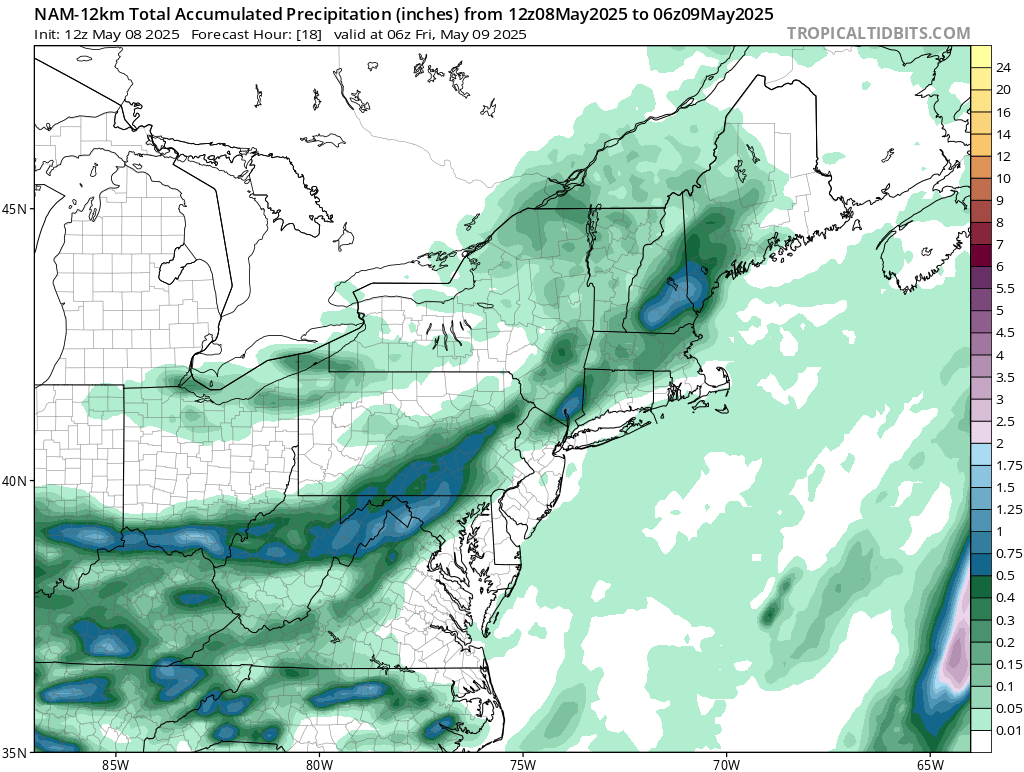
This was the 12z NAM until 2am tonight.. Big fail close in on all models though

-
How has today been for you?
-
Chris, at 1.32" and climbing
-
Naw but I wouldn't be surprised if the white Mountains see some late Saturday like I was saying yesterday
-

Central PA Spring 2025
Itstrainingtime replied to canderson's topic in Upstate New York/Pennsylvania
Not a drop here.


.png.0440790abacb10e2e77af4594dbc0f28.png)