All Activity
- Past hour
-

November 2025 general discussions and probable topic derailings ...
dendrite replied to Typhoon Tip's topic in New England
He does it every Nov/Dec. Investing way too early for his climo. He needs to move up to Glens Falls or Binghamton and handle some real crime…like not putting on your blinker at a stop sign. -
Its coming! ❄️
-

November 2025 general discussions and probable topic derailings ...
Torch Tiger replied to Typhoon Tip's topic in New England
yeah it's disappointing to see everything slip away like that. Especially with the tremendous SSW hype and etc. -

2025-2026 ENSO
TheClimateChanger replied to 40/70 Benchmark's topic in Weather Forecasting and Discussion
Thanks for the update, Don. This looks similar to the wintertime pattern I got when I ran the warmest CONUS Novembers forward, with cold in the Upper Midwest and Pacific Northwest. Warm south and east, with a stout SE Ridge. Hoping the ridge is underestimated a bit and milder air is able to infiltrate the Great Lakes region as well as we head into mid December. -

November 2025 general discussions and probable topic derailings ...
CoastalWx replied to Typhoon Tip's topic in New England
He knows NYC is toast -
November 2025 general discussions and probable topic derailings ...
dendrite replied to Typhoon Tip's topic in New England
LR models warm…they’re horrendous LR models cold…we take and we post -
November 2025 general discussions and probable topic derailings ...
CoastalWx replied to Typhoon Tip's topic in New England
You can’t say that. But I wasn’t a fan of how guidance lost the NAO ridging over the last two weeks. I think we’re gonna have some chances, fingers crossed. -
I like how we all gave MJO812 weenie emojis for saying everyone overestimating SE ridge and he was completely validated. I will admit I have a warm bias. Maybe some others should step up and admit it too.
-
 Certainly slipping away for a good month south of there
 -
damn good point
-
Thoughts are you should wait a few days before even considering something 8 days out a possibility.
-
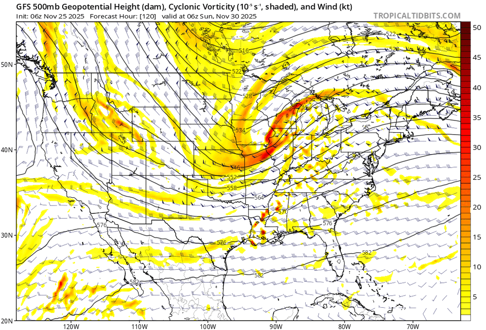
All guidance appears to be "struggling" with the amplitude of shortwaves coming down the ridge from AK to CA. This is an area where minor perturbations grow into mature trofs or deep upper lows. It may or may not also be a data sparse region. This is leading to huge intra-and inter-model variability with respect to west coast trofs, their amplitude, and which is dominant.
-
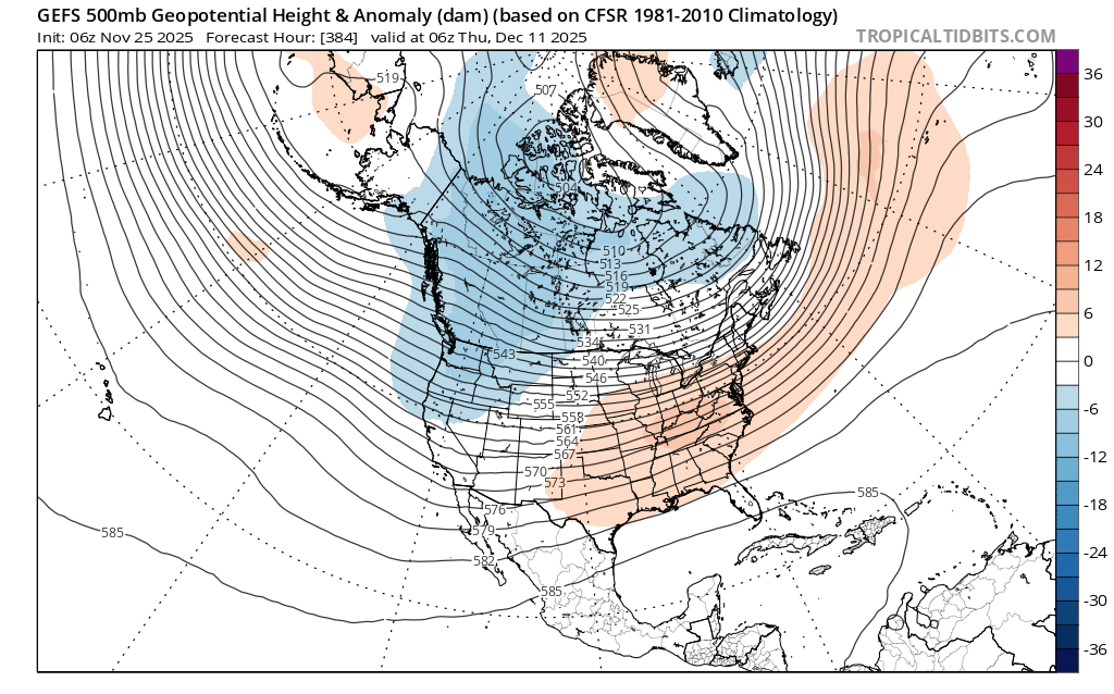
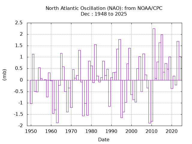
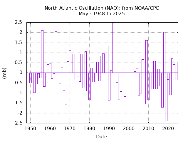
December has been one of the most challenging months for sustaining deep -NAO patterns since 2011. Pretty much the opposite of May. This is one of the reasons why we haven’t seen a repeat of record December snows from 2000 to 2010 around NYC.
-
Can’t argue with you. This is the time of year you want to hit your stride and start to peak. That ain’t the Eagles. Do they do anything well? You could say defense but now the injuries are piling up. The thing about the NFL this year is I don’t see any elite team, everyone looks beatable.
-
Check out this discontinuity between 0z and 06z on the GFS. That's day 5.
-
November 2025 general discussions and probable topic derailings ...
Torch Tiger replied to Typhoon Tip's topic in New England
without a more favorable pattern, looks unlikely. Unless you mean far nne (threats) -
November 2025 general discussions and probable topic derailings ...
Torch Tiger replied to Typhoon Tip's topic in New England
ensemble blends are fine to get a general idea /big picture
-
everyone should switch to Bluesky
-
November 2025 general discussions and probable topic derailings ...
CoastalWx replied to Typhoon Tip's topic in New England
It certainly opens up the door to good thermal gradient. And obviously yes, that powers storms. But with that comes some southeast ridge and then the storm track might get dicey. i’m just saying these are some of the things that I kind of see that perhaps are a little concerning to me, but I’m not writing off December or anything like that. It’s too far out to really determine that just don’t be shocked if all this snowy talk doesn’t exactly happen at least in southern New England. Probably will be a great December up north. One day we’ll sit back with a massive ridge out west where Calgary is 85 in December. I’ll sit outside and smoke a cjgar without a care in the world as the snow falls on my nude body. -

Nov 28-30th Post Turkey Day Wintry Potential
Baum replied to Chicago Storm's topic in Lakes/Ohio Valley
The early ride up the roller coaster is my favorite part. -
The worries are beginning . Energy Mets on right track of Dec 1-15 of snow threats and then ending
-

November 2025 general discussions and probable topic derailings ...
MJO812 replied to Typhoon Tip's topic in New England
No concerns yet. The models are horrendous in the long range. We should enter a mild period thought in mid December. -
Meteorologists, What are your current thoughts regarding the December 3rd system? Do we have a good shot at some early-season snow, and if so, what needs to occur for such an event to happen?
-

November 2025 general discussions and probable topic derailings ...
WinterWolf replied to Typhoon Tip's topic in New England
But wont that help us? I mean oresssine cold out weff go…And the big contrast in temps can produce some good baroclonicity? Or am I completely mistaken lol? -
November 2025 general discussions and probable topic derailings ...
Torch Tiger replied to Typhoon Tip's topic in New England
6z gefs milder in the extended. Canada is cold but more normal at end, with S US roasting. Concerns