All Activity
- Past hour
-

2026-2027 Strong/Super El Nino
roardog replied to Stormchaserchuck1's topic in Weather Forecasting and Discussion
On top of that, a model forecast for a strong +IOD in late summer and fall isn’t exactly a sure bet. -
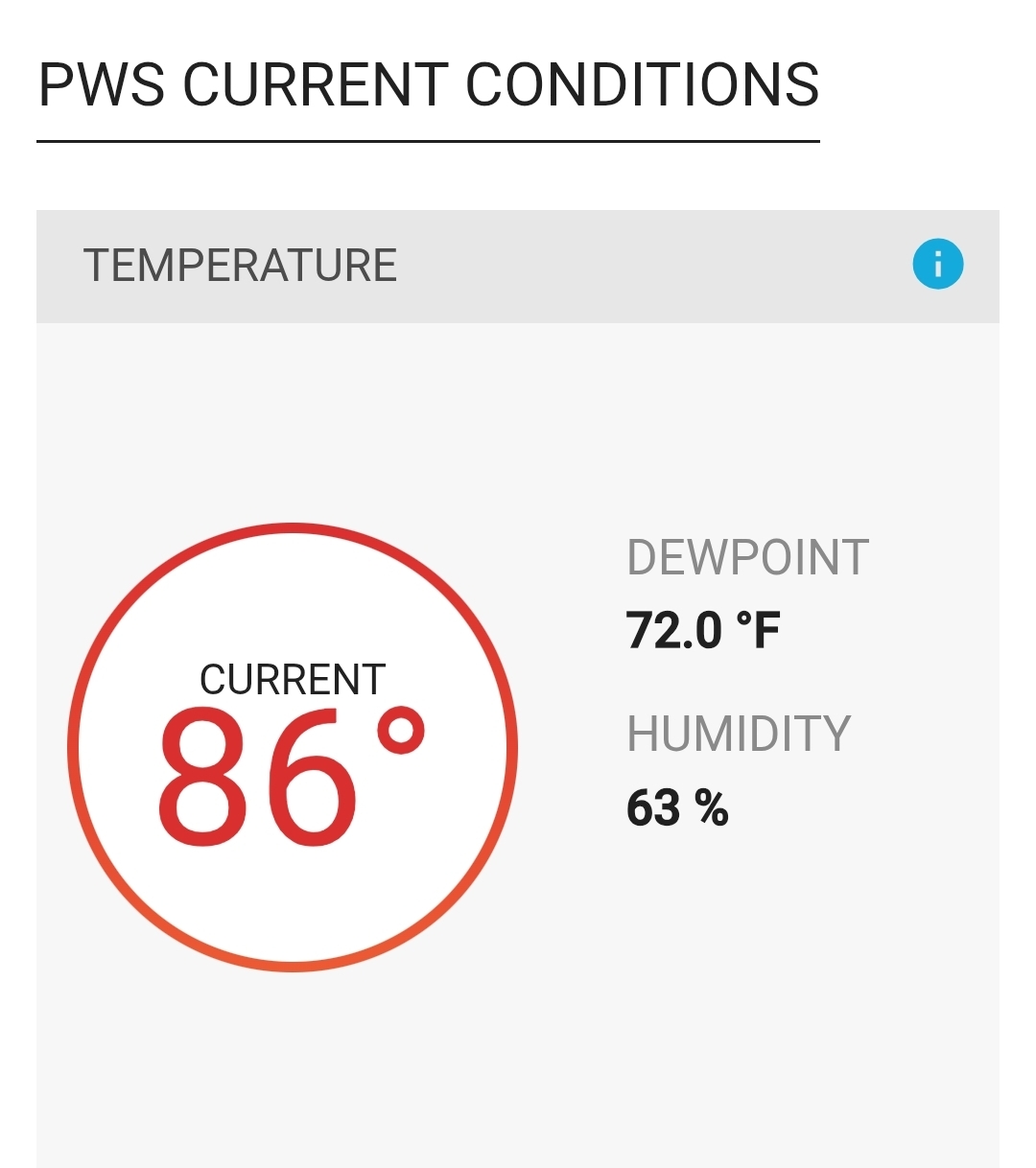
Currently 87F here. DP 67%, RH 60 as of 10AM.
-

E PA/NJ/DE Spring 2026 Obs/Discussion
The Iceman replied to PhiEaglesfan712's topic in Philadelphia Region
I think someone in the area hits 100 today. My forecast point and click jumped to a high of 99. All time May high temp is 97F for PHL, KRDG, KABE and 99F for TTN, ILG, and KACY. The daily hi records for today might be broken at every single station in the CWA. -
BML had a low of 47° and went from 53° to 84° in 3 hours.
-
3km liking southern VT/NH into northern ORH County today
-
Yeah I swear every 10 mins when I refresh my station it’s up another degree. 81.1° and there’s still soggy spots in the yard. 10am ASH and FIT gone wild
-

2026-2027 Strong/Super El Nino
40/70 Benchmark replied to Stormchaserchuck1's topic in Weather Forecasting and Discussion
This is what I was driving at.....the very strong +IOD didn't prevent the La Nino in 2023, so how can we be confident that it will this year.... -
It has happened before. Highest temp in May (maybe even April for someone on here one year?)
-
I was thinking that might be the case for me
-
2026-2027 Strong/Super El Nino
40/70 Benchmark replied to Stormchaserchuck1's topic in Weather Forecasting and Discussion
Well, you could do that with any period....add March in and winter wasn't that cold. -
85 at home, 85 at work before 10AM Let's add 10!!!
-
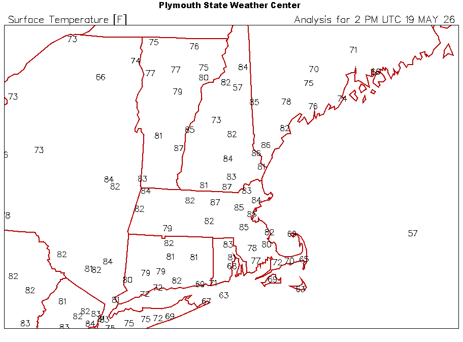
86 to 88 at 10 am in the local area. Looking at higher res vis sat, clouds don't appear to be an option. Very low wind to offer ventilation... Does this solitary afternoon end up being the biggest heat of the summer?
-
2026-2027 Strong/Super El Nino
40/70 Benchmark replied to Stormchaserchuck1's topic in Weather Forecasting and Discussion
Of course, I'm just saying it's a consideration. I used to be oppose to it, but have started incorporating it a bit. -
Hilarious ... thing is, ...I wondered that last winter. Seriously. I mean, I ask and ask and looked it up, and no one/source could give me a clear a-b-c, much less impression, about how these tools derive their values. Looked suspiciously like derivatives have nothing to do with it. Anyway, perhaps there's something about their "mechanics" that is more than lesser known these days. Haven't followed thru. But I tongue-in-cheek mused that these AI tools were just Google on steroids, going out and reading the entire Internet cloud, where there's obviously a fairly large/significant influence statistic of Ineedsnow mongers ... That would explain why the snow was always farther N-W ... etc haha.
-

2026-2027 Strong/Super El Nino
GaWx replied to Stormchaserchuck1's topic in Weather Forecasting and Discussion
I’m not @snowman19but I can tell you based on the link below that 2023 was similar to 1997 in having a very strong +IOD. 2018 was next and then 1994. 1972, 1982, 2006, and 2015 were next (still moderately strong). Keep in mind: -There’s been a decided longterm rise of the IOD in this table. So, it isn’t adjusted for long term trends. That’s why 2018 had such a strong +IOD despite El Niño being weak. -IOD tends to peak ~Oct-Nov and falls off in winter, especially when strongly positive in autumn. So when moderate to strong +IOD in SON, it about always has had a notably lower DJF vs SON. https://psl.noaa.gov/gcos_wgsp/Timeseries/Data/dmi.had.long.data -
AI learning what the people want
-
-
86 in the woodyard. Umbrella up.

-
Low chance
-

Central PA Spring 2026 Discussion/Obs Thread
Itstrainingtime replied to Voyager's topic in Upstate New York/Pennsylvania
That storm moved NE out of Centre County and the core probably missed you just to your southeast. My wife and I were sitting outside last night watching the lightning show from over 100 miles away. -
Looks like for the rest of May, the areas that really need the precip should see some improvement.


-

2026-2027 Strong/Super El Nino
MJO812 replied to Stormchaserchuck1's topic in Weather Forecasting and Discussion
Yes but there are also other factors. Either way , this will be a milder winter than last winter. No doubt about that. That could be a good thing since suppression will most likely not be an issue. I will take my chances with that even if its snow to rain events. -
There arguments against it (rising heights, dubious trigger) are legit, but it's tough to ignore that most CAMs have at least a couple of cells. I think that today warrants a 20% PoP.
-
12Z HRRR is very quiet for this afternoon and I just finished watering. Hopefully we will start getting some rain tomorrow.
-
84 ... feels meaner