All Activity
- Today
-
How does this relate to enso? Oh yeah, it doesnt
-

2025 Atlantic Hurricane Season
BarryStantonGBP replied to BarryStantonGBP's topic in Tropical Headquarters
K -
Talk about a heater. Basically two islands in the gigantic expanse of the Atlantic basin getting all the hits. It’s worse than Moose Glute, ME getting all the snow.
-
 Idub is that you?
 -
how does Brady statue look? goated? I forgot about that
-
the new Florida. hit after hit
-
You'd be worse off tonight. Luke Bryan and the Patriots. Good luck getting back to lowell .
-
Think of our Atlantic Canada friends!
-
45 days on Mlb roster prior to September 1st or 130 at bats. That's what makes them not a rookie. Are they worried they are going to end up over 130 ab's?
-

2025 Spring/Summer Mountain Thread
Tyler Penland replied to Maggie Valley Steve's topic in Southeastern States
Been busy this summer so haven't been on the forum much. Absolutely loving this weather. I went out to Yellowstone and the Beartooths and brought their temperatures back with me so you're welcome. LOL -

Central PA Summer 2025
Mount Joy Snowman replied to Voyager's topic in Upstate New York/Pennsylvania
Not sure what the weenie emoji was for on this post, as MDT has also started with a negative departure every day this month. -
CAMs (18Z 3K NAM/0Z HRRR) aren't too enthused about much more than garden variety tomorrow. EHI is pretty low. SPC may have been over-optimistic expanding the slight risk into all of S. WI and adding a 2% tornado contour.
-
i was in the dead-center of this, working night-shifts in Mansfield MA. Driving home. I honestly didn't know if i was gonna make it. lol http://users.rcn.com/rmacedo/aug10.htm
-
 I saw those as well as willets and black crowned night herons.
 -

SE Area of Interest--10% two day, 20% five day odds
Kevin Reilly replied to WxWatcher007's topic in Tropical Headquarters
What that storm did do is up well the waters pretty good here in Kitty Hawk water temp has gone from 84 to 75 in the past day or so; I am sure this is temporary. -
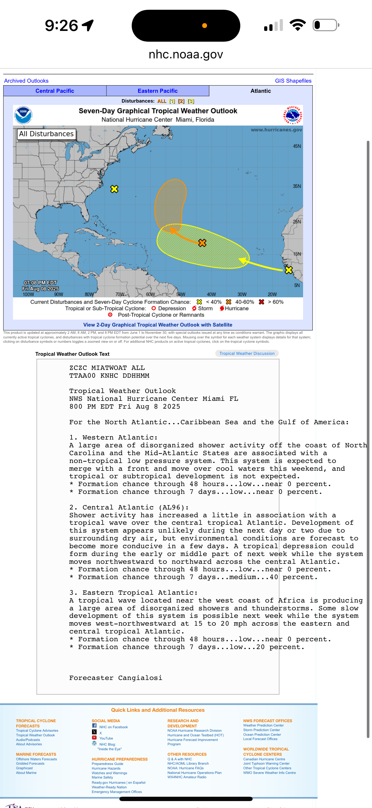
NHC at 8pm. Eastern Atlantic is the wave to watch.
-
 Happy Friday everyone.
 -
It’s cray cray at the lack of any thunderstorms this season.
-
August 9th-10th 2000
-

SE Area of Interest--10% two day, 20% five day odds
TriPol replied to WxWatcher007's topic in Tropical Headquarters
You see this?! SE Area of Interest! Ten percent in two days, twenty percent in five! What is this, a weather forecast or a scratch-off ticket?! Ten percent?! That’s not a forecast, that’s a suggestion! You can’t get me worked up over something with worse odds than me getting a date on a Saturday night! And twenty percent in five days?! What am I supposed to do with that information? Stock up on bottled water, but only drink a fifth of it? Keep one galosh by the door, just in case? These meteorologists….. they put out these ‘Areas of Interest’ so we’ll all go, ‘Oooh, something’s coming!’ Meanwhile it’s a little puff of cloud in the middle of nowhere. I’m getting anxiety over a moist spot on the radar! And you know what’s gonna happen? Day six—poof! Gone! Back to tracking tropical waves in Chad! CHAD! The only waves in Chad should be in a swimming pool!” -
TROPICAL WAVE LOCATED IN CHAD, AFRICA (NOW 0/20, GTFIH!)
TriPol replied to BarryStantonGBP's topic in Tropical Headquarters
This has been, without a doubt, one of the most relentlessly terrible hurricane seasons in recent memory. Not terrible in the exciting, blockbuster-movie way. Terrible in the ‘please someone turn the channel’ way. We’ve been tracking every swirl of wind and puff of cloud in the Atlantic, and, friends, it’s so bad… we’re now monitoring tropical waves in Chad. Yes, Chad. A landlocked country. That’s where we are. We’ve deployed our most advanced meteorological tools, consulted every weather model, and even stared meaningfully into the middle distance — nothing. These storms have been as thrilling as a DMV waiting room with no Wi-Fi. So, I urge everyone to remain calm, stay informed, and maybe bring a book. Because if things keep going like this, our next ‘storm of interest’ will be a cumulonimbus over Saskatchewan. -
 Ospreys,Eggrets (lesser and greater) were probably there.
 -
 80/58 temp split today...should make it into the 50's again by morning.
 -
 I've been on this forum or lurking for seemingly 10 years and the first major threat to the CUSA always has Tampa in the cone, it's like a tradition. Not once has it ended up affecting us