All Activity
- Past hour
-
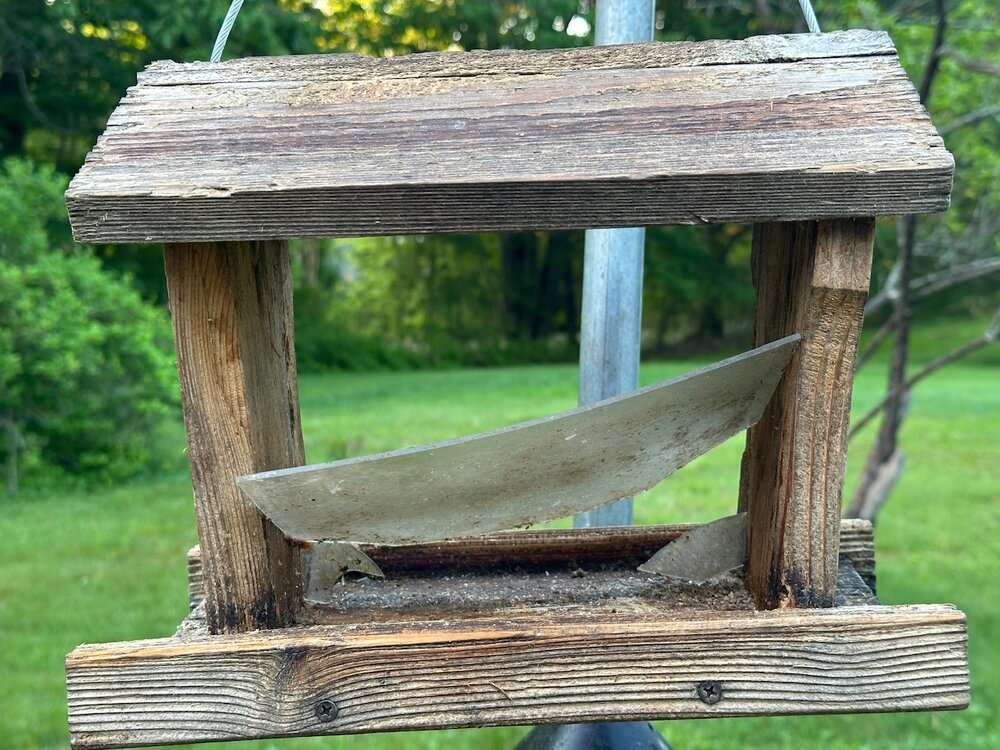
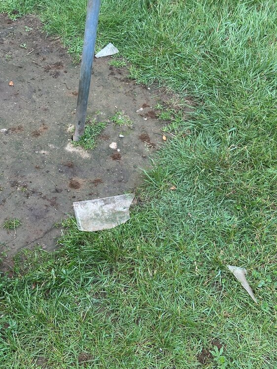
I assume this was a bear. Never broke the hook or pulled the feeder down. Just punched, smashed, and ate.
-
Could be some strong storms tomorrow CT into nrn RI and points north tomorrow.
-
Doesn’t look violent though.
-
54 here not a fan on.
-
Watch your backdoor tomorrow
-
2.89" of rain overnight through 7 AM (Eastern time) and still raining. Feast or famine.
-
Yeah, it looks a little cloudy now, but we’ll see. I expect a little sun. At least down here.
-

2025 Lawns & Gardens Thread. Making Lawns Great Again
RUNNAWAYICEBERG replied to Damage In Tolland's topic in New England
A meme of TACO boy popped up. Thanks for coming around… -
This one long range climate model initialized in 2013 did a great job forecasting the +PDO shift in 2014 that lasted through 2018. So we always have to evaluate on a case by case basis. Plus it’s tough to know when the model is just in repeater mode or actually seeing a shift until we see the verification. https://www.nature.com/articles/ncomms11718 The negative phase of the Interdecadal Pacific Oscillation (IPO), a dominant mode of multi-decadal variability of sea surface temperatures (SSTs) in the Pacific, contributed to the reduced rate of global surface temperature warming in the early 2000s. A proposed mechanism for IPO multidecadal variability indicates that the presence of decadal timescale upper ocean heat content in the off-equatorial western tropical Pacific can provide conditions for an interannual El Niño/Southern Oscillation event to trigger a transition of tropical Pacific SSTs to the opposite IPO phase. Here we show that a decadal prediction initialized in 2013 simulates predicted Niño3.4 SSTs that have qualitatively tracked the observations through 2015. The year three to seven average prediction (2015–2019) from the 2013 initial state shows a transition to the positive phase of the IPO from the previous negative phase and a resumption of larger rates of global warming over the 2013–2022 period consistent with a positive IPO phase.
- Today
-
-

2025-2026 ENSO
40/70 Benchmark replied to 40/70 Benchmark's topic in Weather Forecasting and Discussion
Yea, this doesn't suprise me. No reason to bet against that for the balance of the decade, with perhaps some better luck and a mismatch season or two thrown in. -
-
Still looking pretty wet for Pit2.......hoping to spend some time on the boat.
-
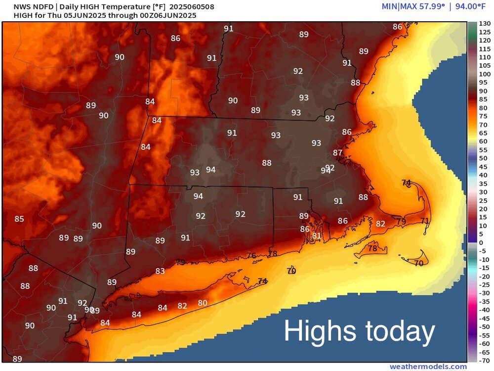
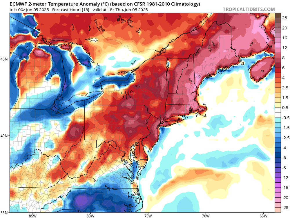
Looks like the warmest readings today will be following the over the top pattern we have been getting since around 2018. Onshore flow for the south facing beaches. The warmest downslope flow in the Northeast will be found in Mass and NH. So the warmest departures and perhaps actual temperatures will be heading to our north today.
-
Supposedly they are more energy efficient that AC, though is mainly only good at night, and if it is a "normal" summer's eve where the temperature actually drops below 80 degrees.
-
Lows of upper 60s or higher are when I start using the AC. 57.4° this morning…didn’t even need the window fans.
-
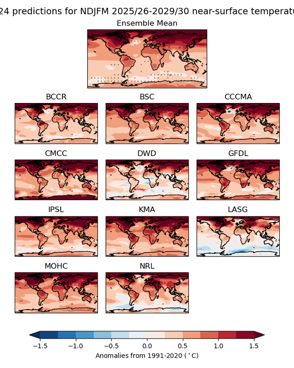
While these climate models forecasts through NDJFM 2030 could just be repeating the 2025 initialization, the winter forecast is still in -PDO mode. It could also be related to the western ocean basins warming fastest to the east of Japan and New England with mean ridges in those positions. I am just putting this forecast out there since it was recently issued. But don’t have any info on how reliable it is or whether the next run will show some type shift later in the 2020s. There is also that cool spot south of Greenland and Iceland which could be related to the more +NAO winters we have seen continuing. https://hadleyserver.metoffice.gov.uk/wmolc/
-
"Hot and somewhat humid conditions are on tap for today with the risk of afternoon and evening isolated showers and thunderstorms...but most locations will remain dry. A much better chance of showers and thunderstorms exists Friday especially north of the Connecticut and Rhode Island border...where localized torrential rainfall and an isolated threat for severe weather will exist. A few showers and thunderstorms will remain possible Saturday but with temperatures cooling to seasonable levels. Mainly dry and seasonable weather is expected Sunday and Monday before the next chance of showers arrives by next Tuesday and/or Wednesday" Not terrible. Summer like.
-
Just ticked that 90 yesterday. 90.0 was the high for the day.
-
Already have the living room down to 66° with just the fans. I have zero opposition to air-conditioning and use it when I’m uncomfortable, I am suggesting that this is not a hot stretch of weather yet.
-
This one had some of my blood in him, was a dog tick, not a tiny deer tick.
-
I'm up to three actual bites and multiple crawlers.
-
I’ve had about 2-3 dozen. Another 3 tonight although 2 were tiny nymphs. Mosquitoes were insane tonight too.
-
So far DVN has confirmed 8 tornadoes from last night. Also, SPC had issued severe watch instead of a tornado watch.
-

2025-2026 ENSO
PhiEaglesfan712 replied to 40/70 Benchmark's topic in Weather Forecasting and Discussion
MAM 2025 ONI (NOAA): -0.1 MAM 2025 RONI: -0.53 May 2025 PDO: -1.71


.thumb.png.4150b06c63a21f61052e47a612bf1818.png)


