All Activity
- Past hour
-
If we are talking KBOS or BDL it's really not difficult at all. 100F is a bit more challenging, and of course >100F is more rare. 98-99 is fairly routine for those spots.
-

2025-2026 ENSO
Stormchaserchuck1 replied to 40/70 Benchmark's topic in Weather Forecasting and Discussion
And while we get ridging, these models are showing Summertime snow near Yellowstone! I haven't turned on my AC yet either -

2025-2026 ENSO
so_whats_happening replied to 40/70 Benchmark's topic in Weather Forecasting and Discussion
Sure just feel he likes to make sure his ducks are in order. No harm no foul. The WPAC is still warm but not excessively warm as it was so chipping away at it slowly is the name of the game. I would be interested to see if the WPAC starts to fire off any tropical systems coming up here with what could be a minor WWB coming up like we saw earlier this month still no typhoon but at least things are trying to get going. -
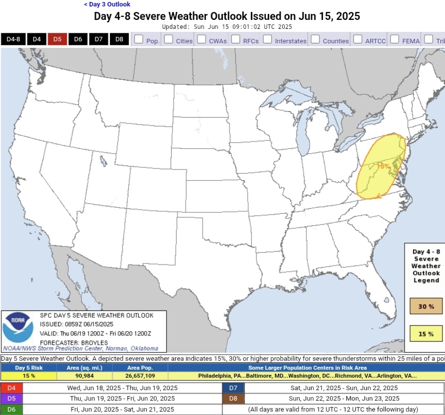
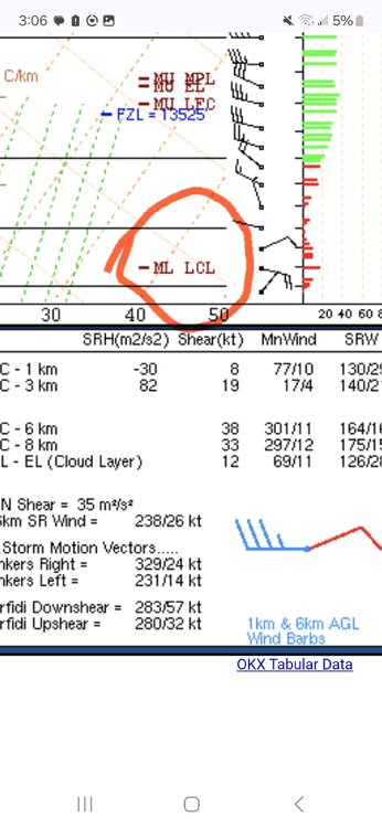
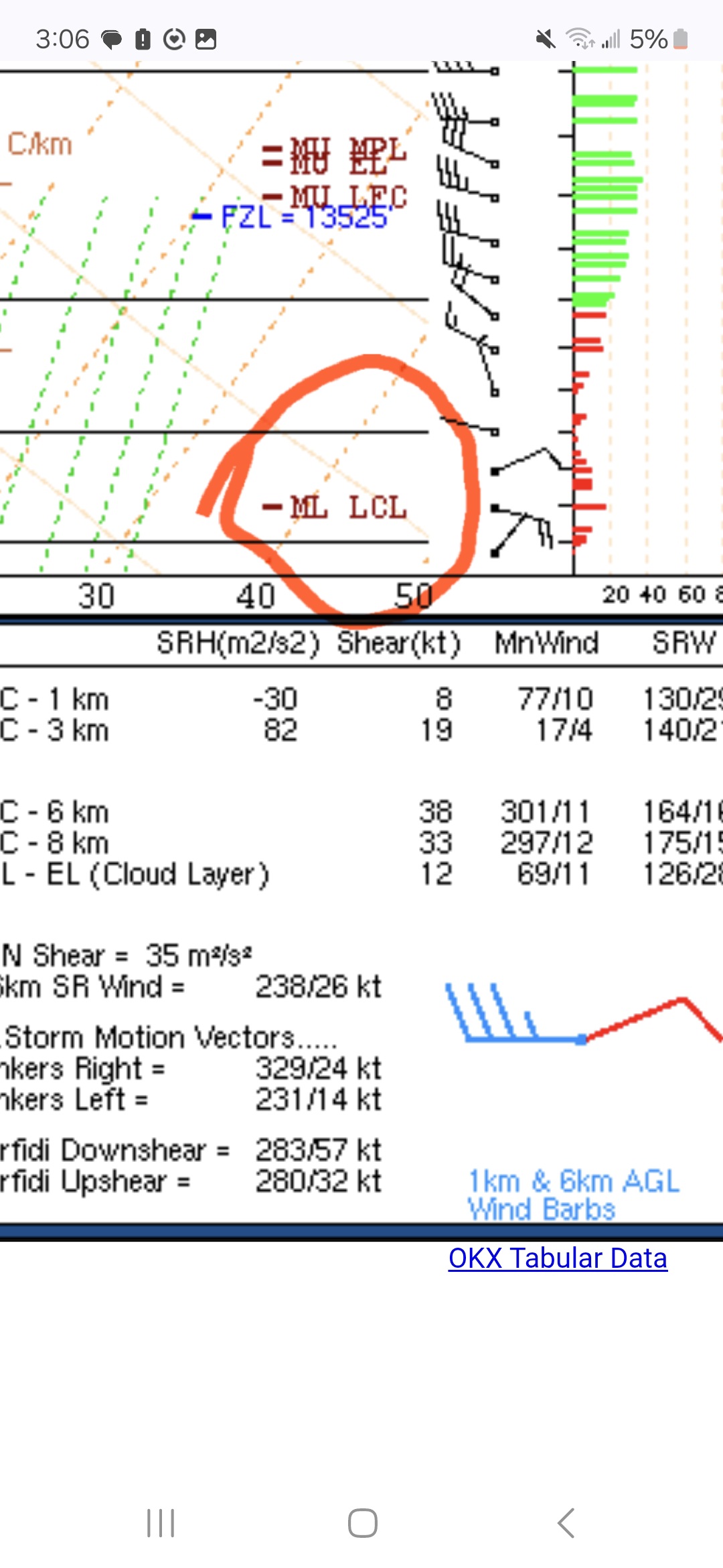
Sorry if you're already aware of this . I didn't stop by the forum yesterday, but for future reference, I would ask the guys at the MA thread . I have seen guys post forcast soundings from pivotal. The LcL should be already plotted and easily visible.
-
Hopefully with the heat next week, we can stay Stein for a bit.
-
You as well as anybody knows how rare it is to get into the upper 90s or triple digits in New England.
-
Thanks for mentioning the micronet. I didn't know about it, only the state wide one. Unfortunately these geniuses decided that out of 23 stations, not a single one will be anywhere in the easte half of Queens. We don't matter much out here on the outskirts. But our property taxes do!
-
Same to you as well. Zero chance they fly sorry just saw this.
-
2025-2026 ENSO
so_whats_happening replied to 40/70 Benchmark's topic in Weather Forecasting and Discussion
Yea there may be a random spot or two that get to 100 at least being shown right now but looks to be potentially our first official heat wave of the season, still a week+ out though so who knows. I will take this lack of heat when I can get it have not had to turn on the AC yet as we have been able to cool down at night properly. May was our first month above average rainfall wise around here in awhile the last time it happened was August of last year and the only reason was because of Debby had that not happened we probably would have gone almost 12+ months below average. -
Schrodinger's cat to Satan's Grundle. You're quite the enlightened bartender.
-
That is a really good and interesting question. This touches on the topic of ENSO as well. As we've discussed before the ENSO region hasn't warmed in the last few decades despite the global average warming. As a result the general circulation patterns that had once typified the ENSO cycle are no longer playing out; at least no in the same way as they once did. This is because El Nino's appear attenuated and La Nina's amplified against the global backdrop. This is the primary motivation of new indices like the RONI.
-
.27 in bucket so far 2 day total of .83
-
Yup its been wash rinse repeat and this week looks like more of same
-
Euro continues to get warmer for next Monday and Tuesday. 40c is nuts
- Today
-

2025 Spring/Summer Mountain Thread
Buckethead replied to Maggie Valley Steve's topic in Southeastern States
The storms were impressive yesterday afternoon. I was mesmerized by the peus over the storm that developed near Black Mountain. Then I caught what I believe to be a crown flash! https://www.instagram.com/reel/DK7lkWixQHK/?igsh=MWwxMXRienFzbGpsOA== Sent from my SM-S908U using Tapatalk -
If it's going to be hot I want it to break records or get big storms out of it
-
Zero complaints on this weather. So comfortable.
-
Fairbanks was warmer than my place The NWS issued a heat advisory for this, close to 80 near the Arctic Circle
-
67F. Too chilly
-
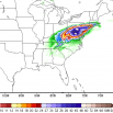
Day 5 Thursday The mid-level trough is forecast to move into the lower Great Lakes and upper Ohio Valley on Thursday, as the cold front advances into the central Appalachians. As the airmass ahead of the front destabilizes, scattered thunderstorms are expected to form along and ahead of the front. The models suggest that moderate deep-layer shear will be in place across much of the northeastern U.S., which will likely support organized storms. Damaging winds gusts will be the most likely severe threat.

-
wow 25 is a HUGE number of 95 degree days, 1993 is WAY ahead at Newark.... 1993 and 2010 being one and two matches my climate experience here. 1944 is absolutely amazing for that era with 20, it's good to see the Hall of Fame summers at the top!
-
to be fair 60s and 70s are not hot lol, 80+ I'd agree with you.
-
Newark 95 degree day season leaders Year Rank Days >= 95 °F 1993 1 25 2010 2 21 2022 3 20 1988 3 20 1944 3 20 2021 6 18 2012 7 17 2011 7 17 2002 7 17 1955 7 17 1949 11 16 2005 12 14 1953 12 14 2016 14 13 1999 14 13 1991 14 13 1987 14 13 1994 18 12 1983 18 12 1966 18 12 2018 21 11 1973 21 11 2024 23 10 2013 23 10 1995 23 10 1963 23 10 1952 23 10 1943 23 10 1911 23 10 1900 23 10 1989 31 9 1981 31 9 1959 31 9 1957 31 9 1948 31 9 2015 36 8
-
2025-2026 ENSO
Stormchaserchuck1 replied to 40/70 Benchmark's topic in Weather Forecasting and Discussion
I don't see anything that says 100 degrees. I see 1 day in the 90s, but maybe we'll get a few in the 90s. -
1955 at the top matches NYC's 16 that year Interesting that LGA used to be cooler than NYC (up to and including 1993 I think.) 2010 matches JFK (they both had 11 that year, the very best summer we ever had!)


.thumb.jpg.6a4895b2a43f87359e4e7d04a6fa0d14.jpg)
.thumb.png.4150b06c63a21f61052e47a612bf1818.png)