All Activity
- Past hour
-
 wet
wet
-
The polar night videos from Svalbard are pretty wild also.
-
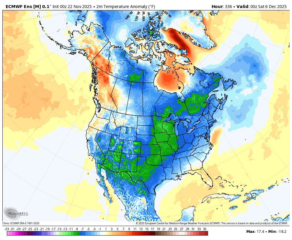
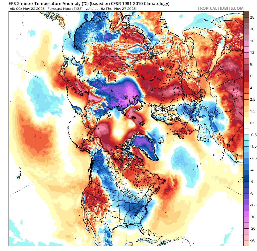
Lol, someone please tell me how this is not good … EPS is still on track for cold to be entrenched by December 5th.
-
I always watch videos from Siberia lol
-

November 2025 general discussions and probable topic derailings ...
ineedsnow replied to Typhoon Tip's topic in New England
In leominster and mod rain.. meh -
 GFS FTW this morning. What a miserable run that was in cold rain
 -
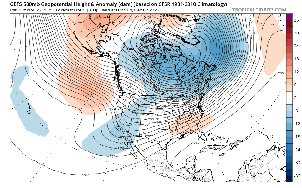
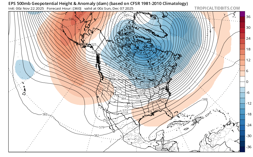
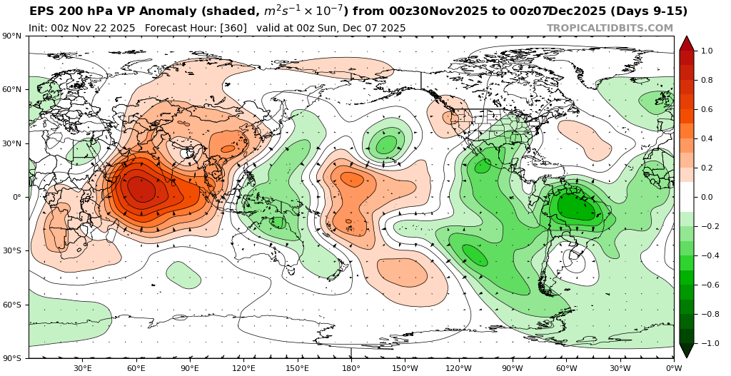
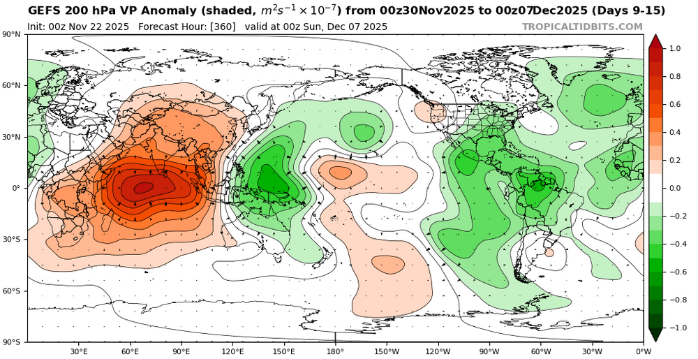
You can already see the model differences between the EPS, GEFS, and GEPS at the end of their respective runs. The GEFS and GEPS hold onto the Western trough and Southeast ridge longer than the EPS. It’s probably due to the GEFS and GEPS showing more Maritime Continent forcing longer than the EPS. One of the EPS biases is dampening the convection too much there week 2 and beyond. This is why I like to use the VP anomaly charts over the RMM charts which can follow the convection to the east. One of the features of recent Decembers is a tendency for the forcing to linger in that region than the models originally anticipate. This lingering convection is why it has been so difficult in recent years to get a clean MJO 8 with no convection in that area like we last had in January 2022. So patience is often required this time of year as the pattern change to colder is usually delayed.


-

November 2025 general discussions and probable topic derailings ...
CoastalWx replied to Typhoon Tip's topic in New England
The stuff I saw showed a big ridge over Santa at 10mb. That’s what I kept saying talk to me when it gets to 50mb. I agree with the warm intrusion as you noted. But otherwise big effing deal. We see these intrusions every winter. I don’t have access to the eps stuff so maybe someone can post it. -
As has been discussed ad nauseam here, I don't believe there's anything to worry about regarding a colder and *potentially snowier* pattern setting up mid-December and beyond for the northeast. The SE ridge will be suppressed enough to allow the baroclinic boundary to slowly inch south and eastward towards the coast, the CPC map you shared is highlighting that (just compare weeks 3-4 to weeks 2-3). It won't happen in an instant, but the cold will try to bleed south into the northern Mid-Atlantic towards the second or third week of December which should offer chances of snow. The nuances in the flow are impossible to figure out at this point, hence *potentially snowy*. Fail mode is obviously if the -PNA overpowers any SE ridge suppression.
-
To quote the great Rob Schneider- “Oh no, we suck again”.
-
I think we know where this is headed folks
-
Some models quickly recover the PV.
-
The real cold on Thanksgiving will be closer to Siberia. You have to give those people credit for surviving in such a cold environment. Luckily, their energy bills to heat their units are relatively low compared to what we would be paying if it ever got that cold here.
- Today
-
I think so. We don’t have gutters in our area either. They’d just be clogged 50% of the year.
-

November 2025 general discussions and probable topic derailings ...
frd replied to Typhoon Tip's topic in New England
There have been winters that provided remarkable snow and ice events. Long duration cold, MECS, etc. nothing weird about that. -

2025-2026 ENSO
Stormchaserchuck1 replied to 40/70 Benchmark's topic in Weather Forecasting and Discussion
End of the 0z EPS is showing a +2std +NAO All the roll forward stuff this year was predicting it for the Winter at about a +0.2-0.3 correlation: - 7 straight +NAO months Feb to August - 8 straight +AO months March to October - Lag from Solar Max 0z EPS mean 360hr: -
End of the 0z EPS is not looking good lol
-
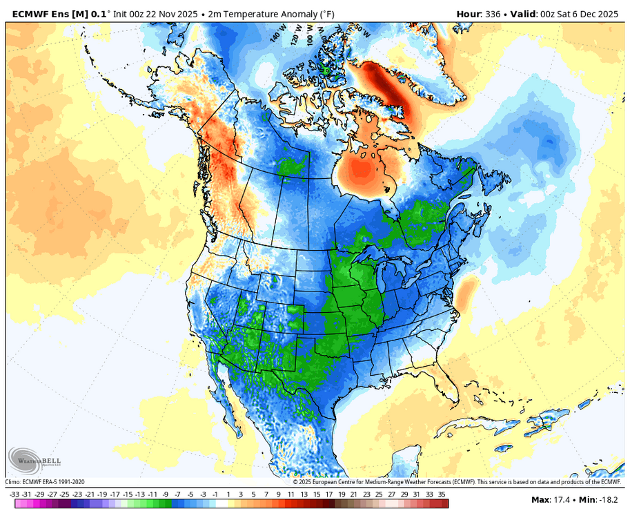
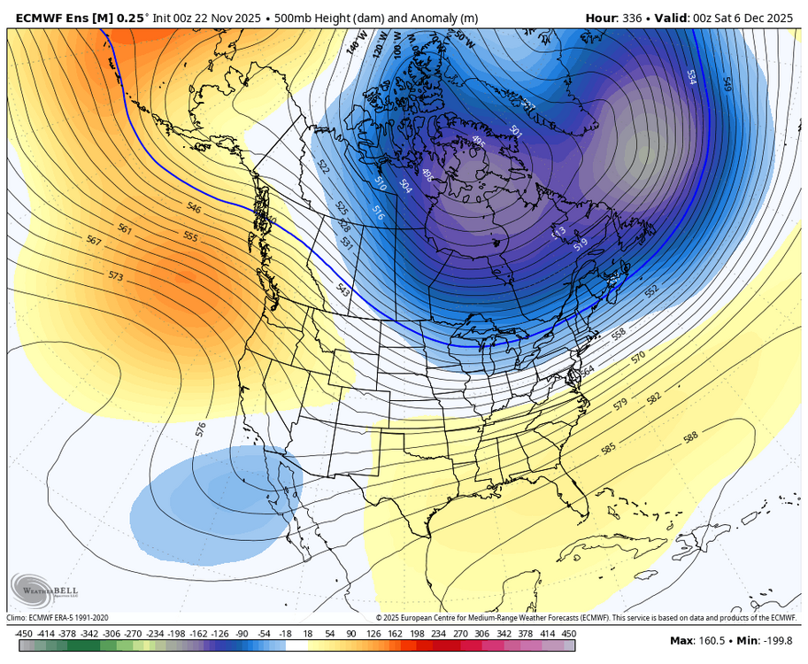
The favorable H5 look for December has slowly degraded on models over the last few weeks. -early Nov models had a persistent -NAO through Dec.. that's really changed to positive around the end of Nov/early Dec -A few days ago there was a strong +PNA on models. That has about disspeared -The -EPO was looking like it would be a strong pattern a week ago. It's still going to happen, but now as strong and persistent as before. By the 2nd week of December it's probably gone The best thing going for us is the Stratosphere warming, which usually "downwells" in +30 days at this time of year... puts a possible -NAO pattern for the 2nd half of December.
-
This guy hasn't been playing with a full deck since day one.. ignore and move on
-
 There have been some really good seasons and storms down there relative to Mid-Atlantic climo. My first season down there was 2013-14, which is my favorite season. Wall to wall winter in DC from January 1-late March. Much like us, the last decade has been rough. We really need to see the return of good coastals. I know Ray hates them, but Miller A’s can be solid from DC to Portland if you do it right. Hopefully everyone can cash in this winter.
 -
Can I ask a dumb question? I’ve noticed that gutters aren’t really a thing in my area, is that because of ice dams?
-
ALEET!!
-

November 2025 general discussions and probable topic derailings ...
WinterWolf replied to Typhoon Tip's topic in New England
Same here. -

November 2025 general discussions and probable topic derailings ...
Torch Tiger replied to Typhoon Tip's topic in New England
yeah i'm ready to max out with snow. not joking, i want 100" -
November 2025 general discussions and probable topic derailings ...
WinterWolf replied to Typhoon Tip's topic in New England
I’m ready for everything..how bout you?