All Activity
- Past hour
-
 The only other time in recorded history we had 5/6 La nina years, we didn't have another La Nina for 7 years following that. And the PDO switched to positive in that time. 20-26 we again had 5/6 La Nina's, so the reversal was not that surprising imo.
-
Met4Cast - UK Weather @Met4CastUK The likelihood of the earliest major sudden stratospheric warning on record is increasing for early November. 67.7% of the GEFS show zonal winds reversing while 86.3% of the ECM ensembles show a reversal. The current earliest reversal on record is November 28th in 1968.
-

2026-2027 Record-breaking El Nino
roardog replied to Stormchaserchuck1's topic in Weather Forecasting and Discussion
The ONI ended up borderline super probably because of all the warm water available but the other indices weren’t nearly that strong. This is where ONI skews the results IMO. If you look at that Nino more as a moderate to high end moderate then this super Nino isn’t as surprising as it seemed early this year. -
DT is sounding the bell regarding the SSWE and its never-seen-before timing in a Super El Nino setup. I guess that means the QBO plots should be crashing at some point on the horizon?
-
If we do get cross polar flow later in November this might move into Canada and then move SE based on a - AO regime. FLXweather-Dave @FXweather26823 In the U.S, we tend to focus on northern Canada for the annual rebuilding of cold air in the Fall, but Siberia is the true cold air factory, and it's producing a surplus right now. Much colder than normal air has spread all the way to, and beyond, the Mongolia & China border.
-

2026-2027 Record-breaking El Nino
snowman19 replied to Stormchaserchuck1's topic in Weather Forecasting and Discussion
Traditional ONI: almost +3.5C RONI: +2.9C The EURO has been dead balls accurate with this event. The over +4C peak it shows for December is not only believable, it’s very likely. Also, the subsurface warming continues. My final call is a December peak of +4.0C - +4.1C (traditional ONI) and +3.5C - +3.6C (RONI). I think the subsurface peaks next month at +13C -
I am starting to get interested now. https://x.com/griteater/status/2115136878211223702 griteater @griteater Such a stable looking GFS run with the SSW (shown here at 30mb). Model runs will vacillate, but this one was a biggie with a SSW on Nov 4 still going at Nov 13
-

2026-2027 Record-breaking El Nino
40/70 Benchmark replied to Stormchaserchuck1's topic in Weather Forecasting and Discussion
I know it sounds cliche, but awful forecasts are the best learning tools....it's all about perspective. You just have to own it and approach with an open mind. -
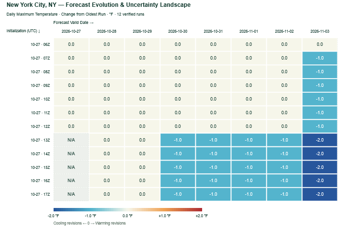
The most recent NBM cycles have grown slightly cooler for the start of November. Nevertheless, readings remain well above average.
-
This October pattern is a near repeat of the one from two years ago when we hit 80°F on Halloween and then again on the 5th of November. I don't know if this will be the warmest October ever, but it will likely have the most >60°F days with all but one day exceeding that high. The 17th ruined a possible perfect score with a high of 53°F. La Nina vs. El Nino doesn't seem to make a difference there. Welcome to extended summer.
-

2026-2027 Record-breaking El Nino
OSUmetstud replied to Stormchaserchuck1's topic in Weather Forecasting and Discussion
Cohen man idk. That dude is always forecasting big snow lols. -

2026-2027 Record-breaking El Nino
forkyfork replied to Stormchaserchuck1's topic in Weather Forecasting and Discussion
weenied for being right -

2026-2027 Record-breaking El Nino
Typhoon Tip replied to Stormchaserchuck1's topic in Weather Forecasting and Discussion
Don't have much time today; just wanna get this out there before I forgotted, as my niece would say- This is likely to physically stress the PV, below. It's the 100 hPa level thermal anomaly centered on D10 off 00z last night, over at the strat-trop monitoring office. Said stressing would likely respond a -AO index as we age on thru the first week of November. This may be what the background soc-media chorus is singing about? Not sure, but this did not have an origin from an SSW event. Just so's that's noted. as I was mentioning to Ray yesterday, it won't make much difference. Timing perhaps. But whether there's an SSW --> -AO (after 20 day lag) or something going on from bottom --> up ( which this appears to be...), there is likely to be a -AO response of some kind in either case. SO, I'm not hugely put off by anyone that thinks it's SSW but just sayn' That's impressive there tho... It's actually in place already as of the initialization last night, but is amplifying out in time. I checked the rotated PCP analysis version and the AO is in fact crashing to about -.5 by Novie 7 or so. The same source - btw- also depicts the PNA rising to an impressive +1.5 to almost 2 SD... We'll see where the hemispheric conveyors set up on the AO stuff but that PNA is a mode change.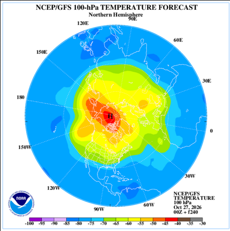
-
People start looking for winter earlier every year…and when it doesn’t show up in late October, well winter gets cancelled.
-

2026-2027 Record-breaking El Nino
Keith Central PA replied to Stormchaserchuck1's topic in Weather Forecasting and Discussion
weak Nino's turn out to be the best for us like 09-10,77-78,..also weak Nina's after strong Nino's..like 66-67. Maybe next winter. -
In Methuen people are taking wood pallets from business parking lots....
-

2026-2027 Record-breaking El Nino
MJO812 replied to Stormchaserchuck1's topic in Weather Forecasting and Discussion
You need a break -
2026-2027 Record-breaking El Nino
MJO812 replied to Stormchaserchuck1's topic in Weather Forecasting and Discussion
Not going to be like that winter unless very strong blocking happens. -

2026-2027 Record-breaking El Nino
A-L-E-K replied to Stormchaserchuck1's topic in Weather Forecasting and Discussion
here for it obviously these are heady times for those of us into anomalous wx of all types - Today
-
saturday halloween with these temps, look out
-
2026-2027 Record-breaking El Nino
forkyfork replied to Stormchaserchuck1's topic in Weather Forecasting and Discussion
poor thing -
2026-2027 Record-breaking El Nino
Keith Central PA replied to Stormchaserchuck1's topic in Weather Forecasting and Discussion
09-10 had a cold December and a snowstorm on December 19th..That's not happening this year, wish it would, sorry -
Where’s 70 today? ….55 here today. Maybe Friday though. And You say the same stuff each October Brett. Last October you were so down on the upcoming winter too ….then you got two 2 footers plus. lol.
-
Judah Cohen blog https://published.aer.com/aoblog/aoblog.html Plain Language Summary The widespread warmth across the Northern Hemisphere (NH) this past summer and now the fall has continued into October (see Figure). However, a series of stretched polar vortex (PV) this month has led to some, albeit modest cooling in Siberia, East Asia and to an even lesser extent far Eastern Canada and New England (see Figure). However, one last stretched PV will bring more intense cooling to Siberia and East Asia and yet again more modest cooling to far eastern Canada and New England (see Figures 3 and 6). Some blocking in the North Atlantic and near Scandinavia will also bring colder temperatures to Europe (see Figure 9). But all eyes then turn to a much larger disruption of the PV that is likely to have an important influence on NH weather late November into December.