All Activity
- Past hour
-
i'm gonna say this every day until the first snowfall
-
 Reading this thread knowing that Chesco uses his data to draw conclusions based on data taken from other locations beforehand is peak denial of what is really going on. It’s quite amusing.
 -
October is just another summer month. I can't wait until November for it to turn 50 and cloudy for 6 months lol
-
let it snow
-

Spooky Season (October Disco Thread)
tamarack replied to Prismshine Productions's topic in New England
I record snow depth at 9 PM, and have had bare ground at that hour of Christmas night four times in 27 years - 1999, 2006, 2015 and 2020. On that last date, my 7 AM report for cocorahs was a fast-disappearing 2", as we had moderate RA and near 50 at report time. The 54/43 temps were +28, the greatest AN for any day since moving here in 1998. (2nd is +27 on 3/22/2012.) -

2025-2026 ENSO
40/70 Benchmark replied to 40/70 Benchmark's topic in Weather Forecasting and Discussion
I wish CPC would do this...CC has exacerbated this disconnect to the point where I make my own intensity composites now and don't even use CPC. -
This’ll be my best September for solar
-
Shorts and t-shirts until Oct 15th or bust
-

E PA/NJ/DE Autumn 2025 Obs/Discussion
Birds~69 replied to PhiEaglesfan712's topic in Philadelphia Region
You're not alone, I used to do this for midnight blues fishing just in case of a pop up thunderstorm. I'd bring a bunch of two ply hefty bags. (It rained more than would you think) People loved it! Good times. Go Phils and Birds! - Today
-
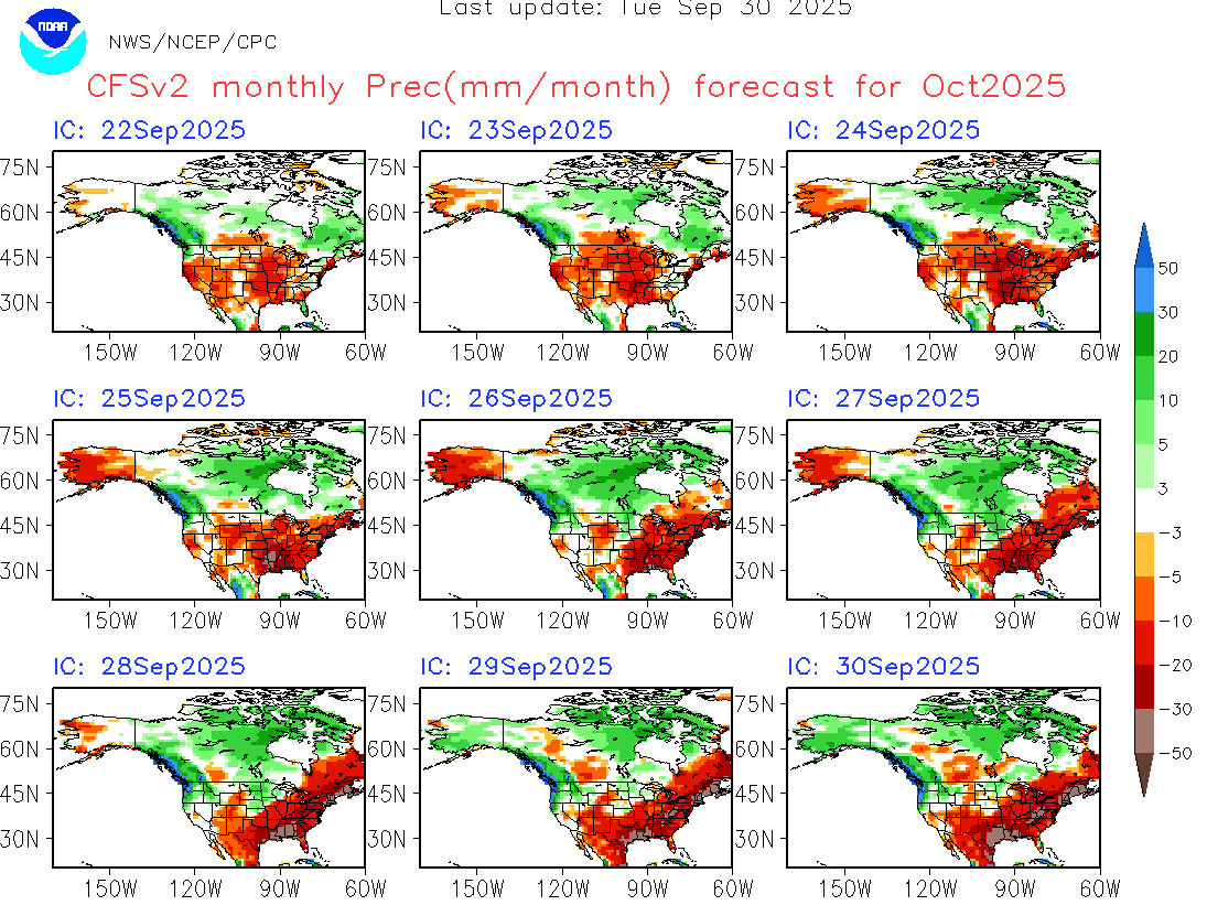
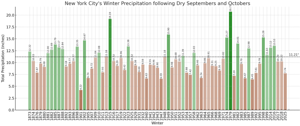
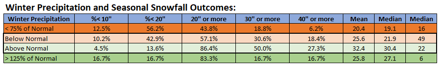
The latest runs of the CFSv2 have consistently forecast a drier to much drier than normal October. A dry October that follows a dry September has typically been followed by a drier than normal winter. At Central Park, where records go back to 1869, 69% of cases with drier than normal Septembers and Octobers were followed by drier than normal winters while 31% of such cases were followed by wetter than normal winters. Put another way, drier winters were 2.2 times as likely than wetter ones. When it comes to more extreme winters (precipitation 25% or more below normal or 25% or more above normal), 22.5% of winters were much drier than normal while 8.5% of winters were much wetter than normal. The very dry winters were 2.6 times as likely as the very wet ones. Drier winters had a tendency for less snowfall than the wetter ones. It should be noted that the coefficient of determination between winter precipitation and seasonal snowfall is very low (0.049). When winter mean temperature is added to the mix, the coefficient of determination increases to 0.288. Once the model is expanded to include Fall Precipitation, Fall Mean Temperature, Winter Precipitation, and Winter Mean Temperature, the coefficient of determination rises to 0.352. Put another way, warm and dry autumn coupled with a warm and dry winter favors below normal seasonal snowfall and explains 35% of the seasonal snowfall outcome. In short, other variables e.g., timing of systems, still have much greater influence on the overall seasonal snowfall outcome.

-
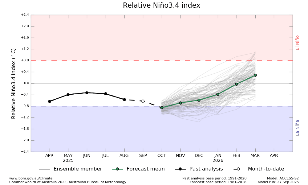
Based on RONI, 2024-5 was a moderate La Niña: ASO 2024 -0.75 SON 2024 -0.81 OND 2024 -0.92 NDJ 2024 -1.07 DJF 2025 -1.12 JFM 2025 -0.89 FMA 2025 -0.67 Related to this, the Australian BoM has switched from ONI to RONI for its official model forecasts: says we’re already in a weak La Niña though it will weaken starting in Nov:
-
Spooky Season (October Disco Thread)
tamarack replied to Prismshine Productions's topic in New England
December 2015 blew away warmth records all over the East. At NYC the average was 50.77. That's +11.9 compared to the 1991-2020 norms and was 6.2° milder than their 2nd warmest (set last year). In fact, 12/2015 was 2.9° milder than the November norm. -
2025-2026 ENSO
40/70 Benchmark replied to 40/70 Benchmark's topic in Weather Forecasting and Discussion
2024-2025 peaked with a RONI of -1.12 and an MEI of 1..borderline moderate. It was certainly a La Nina, again, unless you are tethering yourself to the ONI, which is ill-advised. It's important to be wholistic considering CC. -
Oh, its 100% drought induced. The Taconic range on the west side of Manchester looks half decent, they had some half decent rain comparable speaking.
-
2025-2026 ENSO
40/70 Benchmark replied to 40/70 Benchmark's topic in Weather Forecasting and Discussion
No...it wasn't. You keep asserting this, but check your facts. The MEI briefly touched 0.5 for one bi-monthlyh period and the RONI peaked at .24 in OND. -
2025-2026 ENSO
40/70 Benchmark replied to 40/70 Benchmark's topic in Weather Forecasting and Discussion
Not really debatable that it's a weak La Nina unless you soley rely on the archaic ONI. https://www.cpc.ncep.noaa.gov/data/indices/RONI.ascii.txt https://psl.noaa.gov/enso/mei/ -

2025-2026 ENSO
PhiEaglesfan712 replied to 40/70 Benchmark's topic in Weather Forecasting and Discussion
Yeah, 24-25 was, in terms of la nina, what 14-15 and 19-20 was for el nino. All are borderline cases, depending on threshold. At least with 14-15 and 19-20, you generally had a basewide warm neutral, maybe weak el nino (depending on what your threshold is, 0.4, 0.5, 3-trimonthlies, 5-trimonthlies, etc). With 24-25, you had a la nina in 3.4 and an el nino in 1+2. Heck, the 1+2 in 24-25 may have had a warmer anomoly than the warm neutral years of 14-15 and 19-20. 24-25 might be the hardest year to classify. Whether you consider it neutral or la nina, it really doesn't fit either in a traditional sense. No other year in history had a 3.4 and 1+2 as disjointed as 24-25. -
2025-2026 ENSO
40/70 Benchmark replied to 40/70 Benchmark's topic in Weather Forecasting and Discussion
KLWM It's a combo meal of bad patterns and bad luck...Chris is right that the PAC het has caused supression and cutters....but we have also had some bad breaks on a regional scale, and for me locally...we have had a couple of seasons that performed well regionally, but my specific area was still boned. -

2025-2026 ENSO
michsnowfreak replied to 40/70 Benchmark's topic in Weather Forecasting and Discussion
This is interesting wrt snow because you are at a safe enough latitude that mild winters can easily be snowier than avg. What first order station are you closest to for temps, ORH? In terms of "being due". For here, i would roughly consider the era of above avg snow dominance to be from 2002-2015 and below avg snow dominance 2016-present, however the above was much more above than the below has been below. -
It’s so early, it has to be drought related. I’ve said it a few times but was shocked in Mt Snow area like 10 days ago. Later up here but town is looking meh with a lot of leaf drop in spots. Kind of going yellow/gold/rust and falling. The Worcester Range on the east side of town and the Spine was looking decent, in the right lighting. I think it has to be drought related. I noticed it even on 89 from like Mreaves area down through Brookfield and the high terrain there is past peak too.
-
Can't spot the reindeer sweater in a crowd? All joking aside, I noticed the same thing this past weekend. I think its been drier south and the trees were more stressed.
-
Might be drought related?
-
Was in Ludlow today, looks like NOV in spots on the drive over. Okemo 50% Leaf drop the rest brownish some yellow. Still some rogue patches of color, but I would avoid that area if your looking at leaf peeping this weekend and certainly Columbus day.
-
I thought the sprinkles were supposed to be confined to the early morning. Still spitting out there.
-
24-25 was weak La Niña IMO