All Activity
- Past hour
-
Cool, wet AM with heavy drizzle. HS football games in the area tonight are going to be sloppy. TH homecoming game tonight. Will be watching on Hudl My grandson is in his senior year.
-

September 2025 OBS-Discussion centered NYC subforum
anthonymm replied to wdrag's topic in New York City Metro
It's disgustingly hot. Today has a mid July feel. -
Sell
-
Love seeing the "blue" NWS headlines showing back up.
-
Its a solid shortwave (though becoming more of an open wave) with decent dynamics and forcing. This certainly isn't going to provide relief region wide but some folks will get lucky and get some rain.
-
Yep. May be time to invest in a cabin near Lake Tahoe lol.
-

2025-2026 ENSO
40/70 Benchmark replied to 40/70 Benchmark's topic in Weather Forecasting and Discussion
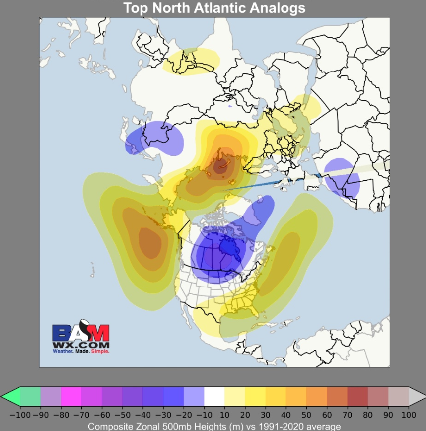
My extra tropical Pacific composite actually looks just about identical to that BAM Atlantic composite. Primary Extratropical Pacific Analogs: 1971-1972, 2017-2018, 2021-2022, 2024-2025 -
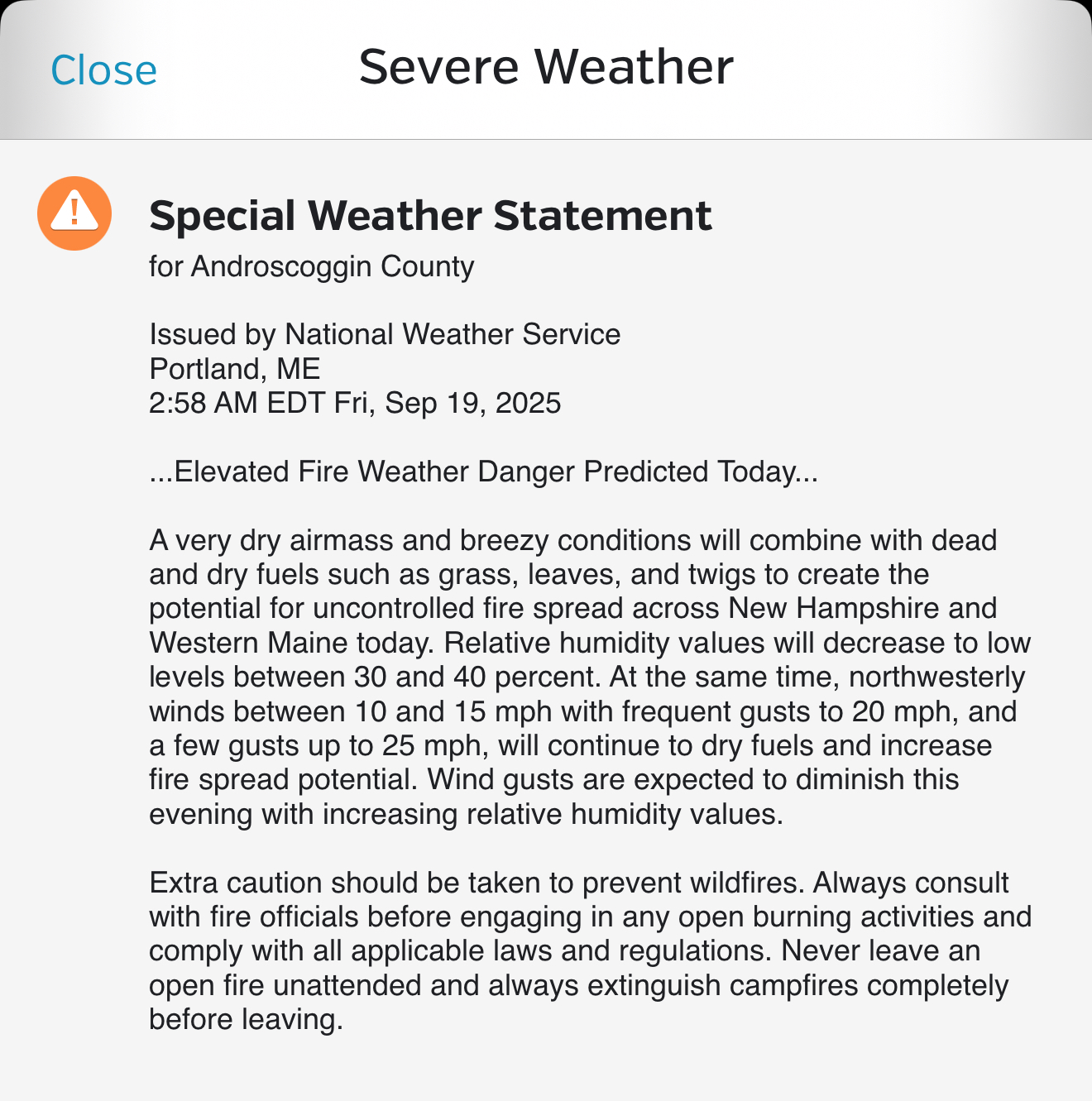
We need it, or we’re going to have a rough wildfire season.
-
I’m going by daily reports I get with SSTAs in each enso region. The trend has been more weak basin wide going back several weeks. Of course today’s report shows a massive change cooler in 1.2 but for weeks it appeared to be weakening with a basin wide with 1.2 no longer the coolest-until again the latest report I saw today.
-
I read this in the NWS discussion for Chicopee, Mass., just now. I read it with great interest and some hope, of course! Upper level ridging begins to weaken and move off to the east with the associated surface high pressure doing the same to start next week. A trough over the Great Lakes moves towards the region as the high makes its exit. With high pressure shifting offshore, southerly to southwesterly flow kicks in Monday into Tuesday, increasing temperatures and moisture which may peak Tuesday according to ensemble guidance. Ensemble probs for temperatures 80F+ remain relatively high across much of eastern MA and the CT River Valley, though they have trended down slightly over the past few runs (not by much, but notable enough to hint at temperatures just reaching 80F rather than exceeding it). Ensembles are in good agreement in mean PWAT values ranging between 1.4-1.5" across the region by Tuesday afternoon, and deterministic and ensemble guidance hints at some instability that could support rain showers. However, given the extended dry weather we`ve seen, confidence remains low in these showers materializing. And if they do, it`s not likely that they provide the amount of rain we need for relief from these dry conditions.
-
Born and raised in Boston and Newton, now in Northampton (just moved here). Surprisingly, I have never been to the BigE, but Sunday is the day! Been to the Topsfield Fair, others in the area. This one, based on the brochure/flyer thing, considering Big Boi from Outkast, other musical acts, events, food, drink. I hear it's $20 to get in for the day, well worth it. And, of course, beautiful weather on tap. https://www.thebige.com/
-
2025-2026 ENSO
40/70 Benchmark replied to 40/70 Benchmark's topic in Weather Forecasting and Discussion
Given the embryonic nature of this cool ENSO event, I'm not sure the -IOD is really going to couple with it enough to be a huge deal....bottom line is I would expect a weak La Nina response...this shouldn't be 2022-2023. However, I think the development of the -IOD does ensure that this will indeed be a cool ENSO season, and that the WPO is likely to be at least somewhat positive....two things that I had already been assuming. -
There will be showers and thunderstorms around Tuesday, could even see an axis of some heavier rain up north (or in the vicinity of the warm front).
-
2025-2026 ENSO
40/70 Benchmark replied to 40/70 Benchmark's topic in Weather Forecasting and Discussion
Looks similar, but I'm a bit more aggressive of some episode(s) of blocking do to the easterly QBO/solar max composite. -
2025-2026 ENSO
40/70 Benchmark replied to 40/70 Benchmark's topic in Weather Forecasting and Discussion

-
the globals have some rain mid week..amounts tbd.
-
2025-2026 ENSO
40/70 Benchmark replied to 40/70 Benchmark's topic in Weather Forecasting and Discussion
The real heart to the drought is over northern New England....couple that with a modest +NAO and maybe its finally my turn. -
Seems like a carbon copy of last fall-rain the weekend after Labor Day then nothing for weeks/months
-
It is, but the convective trend has reversed with shear and dry air decreasing. This is why the models are once again getting bullish on organization and intensification this weekend.
-
Just my opinion but this air mass arrival's the shot across the bow - symbolic hearkening that the next might be more discerned. Probably we recover with at least tepid warmth later next week ... normal after these first 'smells like autumn' marginal froster deals - less marginal across NNE of course.. It's also ( as an aside...) like a 'sub-continental tuck' air mass. It's not really continental in scale. It is just a transient short duration cool shot curling an autumn air mass sneakily through Quebec. Buffalo has no idea it's happening - straight N shot for 24 hours. Altho it may try to cheat radiate one more night before it rolls out. The more canonical sab air mass looks more PNA-ish. It's almost just a reflection of how our geodesic circumstance sucks cold into this specific region ha
-

2025 Atlantic Hurricane Season
Wannabehippie replied to BarryStantonGBP's topic in Tropical Headquarters
Gabrielle is still a naked swirl this AM, with all the convection displaced far from the center of circulation. Center is somewhere to the south and west of that blob of convection. -
Honestly, the most concerning thing, at least as far as snowfall is the drought. These typically aren’t easy to break, especially when in place for several months. They form a feedback cycle. And parts of the northeast are historically dry As far as the SE ridge, I think we do see much more SE ridging this time around due to the state of the Atlantic. BAMWX actually touched on this yesterday
-
Front is through. A little chill when the sun is behind the clouds. 66/56 but dews will be droppin.
-
Today could be the day, Burn it all down.
-

September 2025 OBS-Discussion centered NYC subforum
MJO812 replied to wdrag's topic in New York City Metro
Im wearing a tank top today