All Activity
- Past hour
-
Warmer regime overall hopefully offsetting Stein.
-
 So 2F warmer...did the effects somehow accelerate after 2016? Because I'm sure 2014 or 15 had setups like this that worked, didn't they?
 -
 Will most of the column from h85 down is nearly isothermal so they all start warming together in this case. Slightly. But the equation gets a lot harder the further southwest you go right now.
 -

Central PA Winter 25/26 Discussion and Obs
canderson replied to MAG5035's topic in Upstate New York/Pennsylvania
Short sleeve weather - next week looks even warmer possibly -
I know there’s been some run to run waffling, but it seems that the overall signal has been for decent precipitation starting around mid week into the following week. It would make sense considering how dry it’s been.
-

Central PA Winter 25/26 Discussion and Obs
Itstrainingtime replied to MAG5035's topic in Upstate New York/Pennsylvania
52.2 here. Feels like 65. As much as I love cold weather, today is a stellar day. -
True BUT this topic never comes up in a vacuum. It’s not like someone comes in here and just says now let’s talk about climate change. What happens is we get a synoptic situation that is being impacted by climate change. It’s impossible not to note that this storm we are tracking right now is being impacted by it being warmer. You’d be under an advisory if not a warning right now of it was 1970 and 2f colder with this same exact synoptic setup. That discussion is muddy because it bridges both topics. And I don’t think the people that shit it down do so because it’s the wrong thread they do so because they are uncomfortable with the topic. Either because they are in denial about what it’s doing to our snowfall or because they are in denial because it’s inconvenient to their preferred ideology. I have no patience or fucks to give about either of those reasons.
-
Yeah it’s pretty solid considering basically zero falls D1-5 except an inch or two on the south coast. It’s mostly D5-15.
-
Seeing some noticeable melting of the snow mounds here. Very welcome break from the Siberian weather pattern we’ve had.
-

February 2026 OBS & Discussion
Freezing Drizzle replied to Stormlover74's topic in New York City Metro
This data will keep me busy for a while. lol I am much obliged. @donsutherland1 -
Should the trends over the last 24 hours pan out tomorrow night, it teaches everyone a few lessons 1. Models suck, and they've been getting worse, for a number of reasons. 2. Some mets/weenies are hard-asses (look at Twitter). 3. Just because an ensemble, OP, or meso model solution is IMPROBABLE, doesn't mean it's IMPOSSIBLE.
-
Is that not a rather large mean?
-
 I assume by thermal boundary you mean more upper air 925-850mb level?
 -
Snow is melting but fairly slow for mostly sunny and 46F day. That sleet content must have some real staying power.
-
This storm is taking a perfect track. It’s just too warm for DC
-
 I have wondered that if the Gulf Stream has indeed weakened, could that be less attractive now to potential low pressures to move along Atlantic coastline miller A style?
 -
48 right now. Drip drip.
-
The high resolution models can pick up on them but the issue here is the higher mountains in our area are southwest and in this case south of the thermal boundary that sets up. The high resolution do show more snow on Catoctin and parrs ridge in Maryland.
-
Beautiful out
-
I don’t agree with the argument but some argue C02 concentration are cyclical. Look I’m on your side I just don’t want to muddy the snow argument because what’s causing the warming doesn’t matter to the is the warming hurting our snowfall argument. Those 2 debates can be severed.
-
Increasingly likely that ORD is headed for the lowest snow totals in February since 2017 and would be in the top 10 for lowest snowfall totals. Pretty interesting stuff.
-
47 / 24 here - warmest since Jan 22nd (49)
-
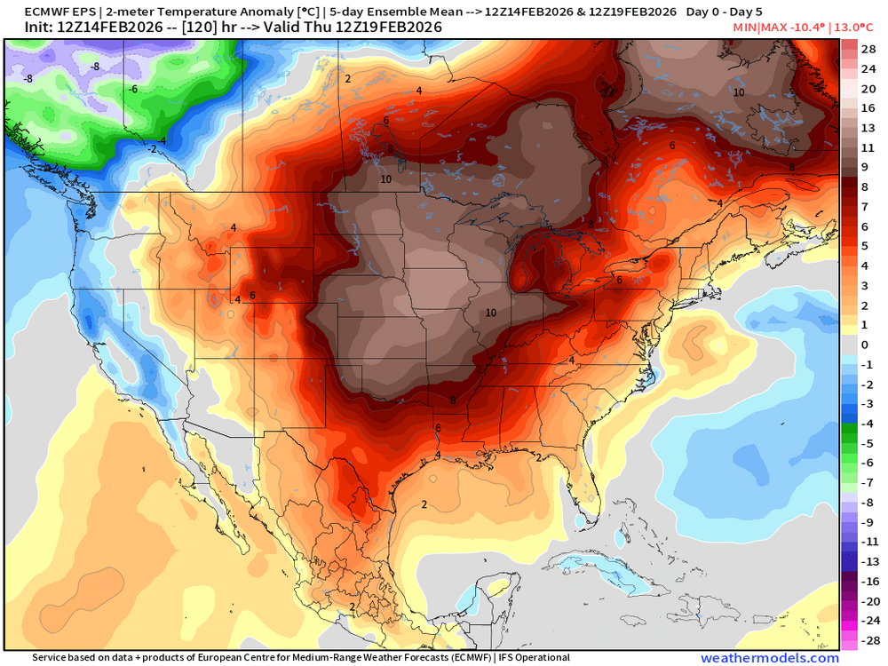
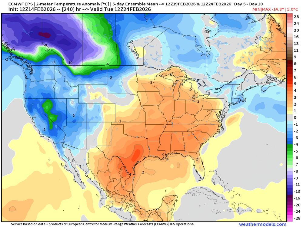
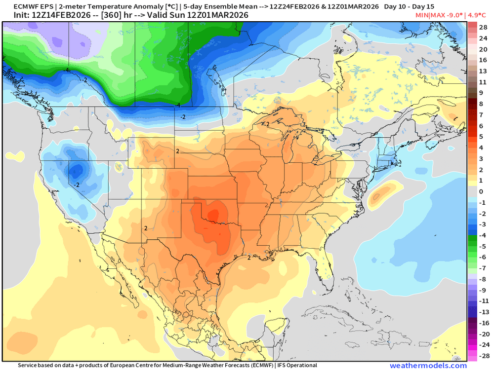
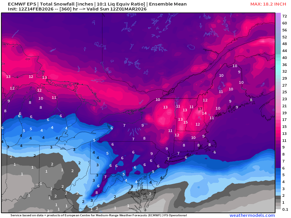
EPS 5 day mean temp anomaly and total run snowfall. There will be chances.
-
The airmass today is actually pretty cold - seasonably cold at least. And yet the warmer spots in the City will tickle 50 and places like Poughkeepsie and Hartford will near or exceed 40. Classic winter feel in the mountains with springtime in the valleys.
-
Central PA Winter 25/26 Discussion and Obs
canderson replied to MAG5035's topic in Upstate New York/Pennsylvania
Car reads 51 at LL Bean in Mechanicsburg. It’s like Christmas Eve out today with traffic.


.thumb.jpeg.f5c6ba9d911ec96b3b124f8606aee58e.jpeg)


