All Activity
- Past hour
-
Might need it a bit further north for best results or we sleet here.. usually way overdone but even half this would be fun
.thumb.png.6301547723bfa7d9d68a0927ab8d405c.png)
-
YES!

-
-13F so far.
- Today
-

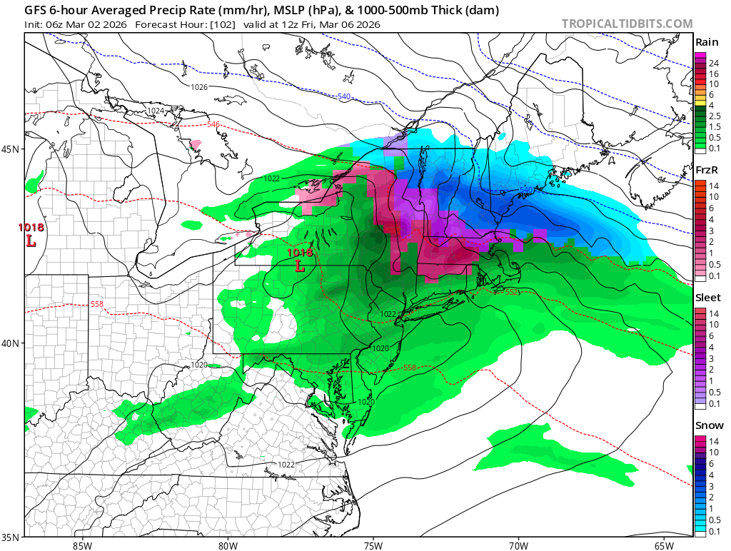
Outta gas and Outta Time: Early March Winter Storm finale
Weather Will replied to Ji's topic in Mid Atlantic
Northwest Montgomery-Central and Southeast Montgomery-Northwest Howard-Central and Southeast Howard-Western Garrett-Rappahannock- Culpeper-Fairfax-Northern Fauquier-Southern Fauquier-Western Loudoun-Eastern Loudoun-Northwest Prince William-Central and Southeast Prince William/Manassas/Manassas Park- 226 AM EST Mon Mar 2 2026 ...WINTER WEATHER ADVISORY IN EFFECT FROM 10 PM THIS EVENING TO 10 AM EST TUESDAY... * WHAT...Mixed precipitation expected. Total snow accumulations up to one inch and ice accumulations up to one tenth of an inch. * WHERE...Portions of central and western Maryland and northern and northwest Virginia. * WHEN...From 10 PM this evening to 10 AM EST Tuesday. * IMPACTS...Plan on slippery road conditions. The hazardous conditions could impact the Tuesday morning commute. * ADDITIONAL DETAILS...Some locations may see up to an inch of snow between late morning and late afternoon today, but roadway impacts should be limited. The primary threat to travel will be overnight from a wintry mix, which could briefly be snow or sleet but primarily fall as freezing rain. Precipitation will change to plain rain by mid morning Tuesday. -
Outta gas and Outta Time: Early March Winter Storm finale
Weather Will replied to Ji's topic in Mid Atlantic
Washington-Frederick MD-Extreme Western Allegany-Central and Eastern Allegany-Eastern Garrett-Morgan-Berkeley-Jefferson- Western Mineral-Eastern Mineral- 226 AM EST Mon Mar 2 2026 ...WINTER WEATHER ADVISORY IN EFFECT FROM 10 PM THIS EVENING TO 1 PM EST TUESDAY... * WHAT...Mixed precipitation expected. Total snow accumulations up to one inch and ice accumulations up to two tenths of an inch. * WHERE...Portions of north central and western Maryland and eastern West Virginia. * WHEN...From 10 PM this evening to 1 PM EST Tuesday. * IMPACTS...Plan on slippery road conditions. The hazardous conditions could impact the Tuesday morning commute. * ADDITIONAL DETAILS...Some locations may see up to an inch of snow between late morning and mid afternoon today, but roadway impacts should be limited. The primary threat to travel will be overnight from a wintry mix, which could briefly be snow or sleet but primarily fall as freezing rain. Precipitation will change to plain rain by midday Tuesday. -

Outta gas and Outta Time: Early March Winter Storm finale
yoda replied to Ji's topic in Mid Atlantic
I am kind of surprised though not to see WWAs. They have been mentioning ice in the zones for a bit now... up to a tenth of an inch. I thought even a glaze brought out WWA criteria -

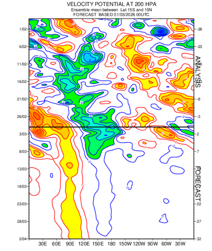
2026-2027 El Nino
jaxjagman replied to Stormchaserchuck1's topic in Weather Forecasting and Discussion
The MJO seemingly is gonna be stuck into the WP which could be for much of March from the Rossby Wave Train,this should help NINA stay alive for the next few weeks anyways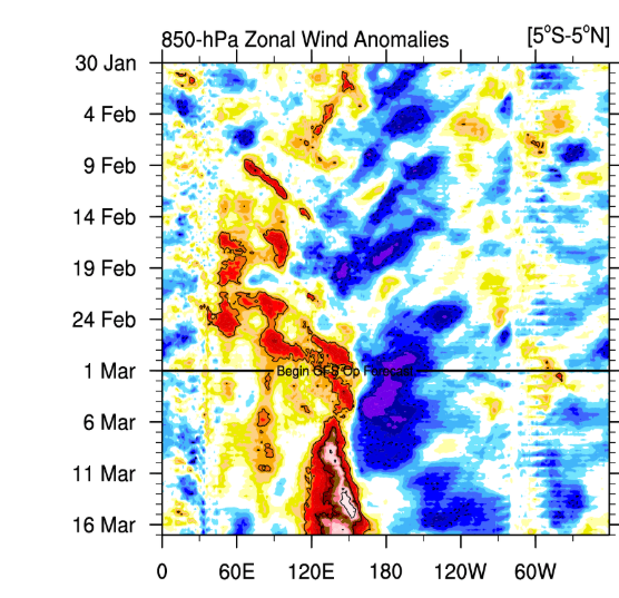
-
.thumb.JPG.418e8a9a2902ae687ec35ff4bc0e038e.JPG)
Outta gas and Outta Time: Early March Winter Storm finale
katabatic replied to Ji's topic in Mid Atlantic
I just drove back home from Richmond tonight and noticed the brining. I travel this route (259 to 48) probably 15-20 times a year and don't remember ever seeing them brined like that. -
Ugh-rude awakening upon our return from south FL tomorrow night Although I did return for the blizzard) for 3 days). Either way, your own bed always wins.
-

Outta gas and Outta Time: Early March Winter Storm finale
stormtracker replied to Ji's topic in Mid Atlantic
Sorry to hear about your dad dude. And don’t worry, we’re paying attention but prob won’t see much out of this. -

Outta gas and Outta Time: Early March Winter Storm finale
jayyy replied to Ji's topic in Mid Atlantic
I’m up in New York visiting my dad - he’s unfortunately very sick. I’ve been up here since the big storm cleared out last week. 3” also fell the 2-3 days following the blizzard. Back home in Maryland WOULD last minute luck into some accumulating snow (in early march) while I’m not there. Book it. The GFS / SREF CONTROL score a coup and someone sees 4”. Prob my backyard. My dad says you’re welcome, weenies. All jokes aside… hope y’all get one last beautiful look at winter. Enjoy it for me -
Son of a bdcf!
-
100 percent prefer the mountains , but a occasional night on the coast in a oceanfront hotel can't be beat.... Hardly anybody around tonight down here in VA Beach. Very peaceful & quiet in the off season...Balcony door open with the sounds of the crashing waves , lights of passing ships in the distance , some cheap whiskey.........................
-
Outta gas and Outta Time: Early March Winter Storm finale
stormtracker replied to Ji's topic in Mid Atlantic
Can’t wait to see pretty flakes flash melting on contact. -

Outta gas and Outta Time: Early March Winter Storm finale
87storms replied to Ji's topic in Mid Atlantic
I don’t want to steal snow from Reagan and Dulles. I’m actually rooting for them to score for the snowfall contest. -

Outta gas and Outta Time: Early March Winter Storm finale
NorthArlington101 replied to Ji's topic in Mid Atlantic
Perfect placement here. Just needs to hold for a few more hours.
-
I think you just need to expand your hiking weather. Next to no one is out on our April to June perfect track gulf soakers which provides a really cool vibe. Additionally, some trails have next to no one on them at anytime for some reason. Personally, I plan to fully use this time period before bugs and yellow jackets infest the trails.
-
Wow, I just came across this article published by the Martha's Vineyard Times which states that they measured 38" in the parking lot of TCI Press printing company in my town. Extremely impressive to say the least. I wonder why that one never made it into the snow reports? https://www.mvtimes.com/2026/02/26/delivered-news-great-blizzard-26/
-
You know we're done with winter when our March write up is on severe weather
-

Outta gas and Outta Time: Early March Winter Storm finale
SnowenOutThere replied to Ji's topic in Mid Atlantic
Some models have it better than others. Though enough show something of that sort where I'm cautiously hopeful. Don't really know where this lift is coming from but GFS and mesos show some 850-700mb temp advection and resulting FGEN which I guess will be something to watch tomorrow. I'm trying to finish my Modern Political Theory essay on Hobbes from home tomorrow ("spring" break) so some nice ambiance would be cool. -
Fired
-
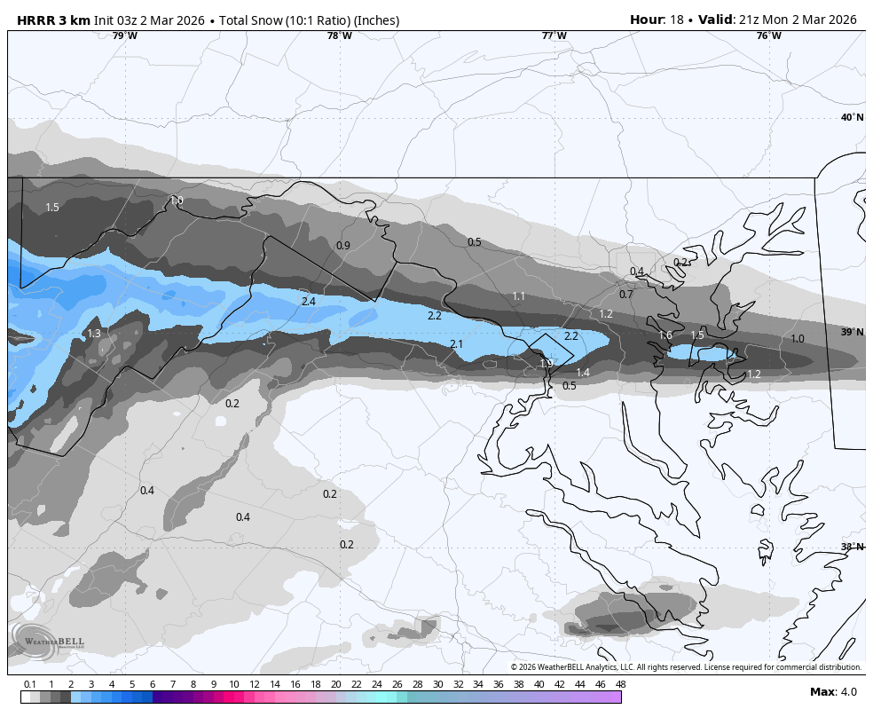
Outta gas and Outta Time: Early March Winter Storm finale
stormtracker replied to Ji's topic in Mid Atlantic
It’s not always sunny in Philadelphia. But prob will be for this one -
Outta gas and Outta Time: Early March Winter Storm finale
NorthArlington101 replied to Ji's topic in Mid Atlantic
Been noticing the Kuchera is greater than 10:1 so that helps with the context here - thanks! Just hoping it’s for DC and notsomuch parts between -

Outta gas and Outta Time: Early March Winter Storm finale
DDweatherman replied to Ji's topic in Mid Atlantic
You’re due, 2” for you -
Outta gas and Outta Time: Early March Winter Storm finale
87storms replied to Ji's topic in Mid Atlantic
I’m fully expecting that Frederick gets no snow from the initial precip and the later round comes in as sleet/rain.

.png.31209fbca09735542165eb10d6c87cdb.png)