All Activity
- Past hour
-
Get in the Basement!
-

Central PA Spring 2026 Discussion/Obs Thread
Voyager replied to Voyager's topic in Upstate New York/Pennsylvania
1.21" yesterday for Tamaqua. -
We got below freezing on the 24th but that was the last time this year so we aren’t going to be far from that record assuming it didn’t get below freezing again which seems highly unlikely but at this point possible.
-
430a update…. Still pinging. Just from looking out window we never flipped. What a bust by HRRR. Fire tgat thing into sun. Need always remember that the warm layer always wins.
-
31F and light freezing rain. Must have gotten a batch of heavy freezing rain last night though. All the tree branches have that grey haze of ice on the branches, and my 7 ft holly bush is so heavy with ice that it's drooping halfway over.
- Today
-

E PA/NJ/DE Spring 2026 Obs/Discussion
RedSky replied to PhiEaglesfan712's topic in Philadelphia Region
North facing spot still has snow -
Great little event
-
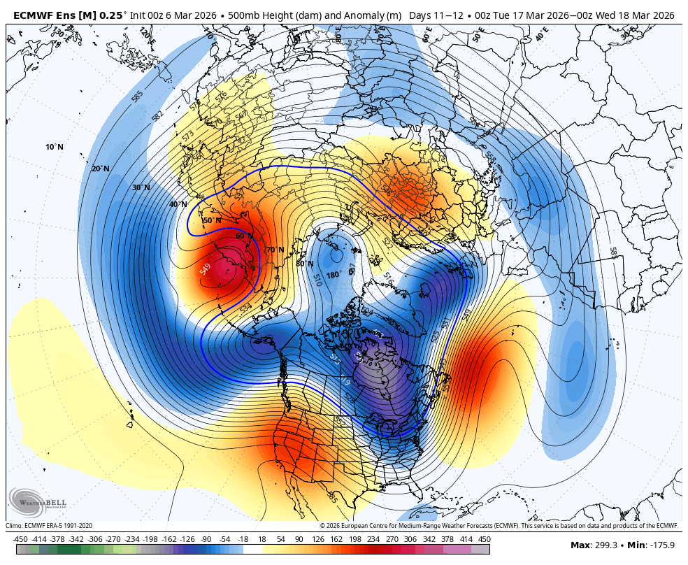
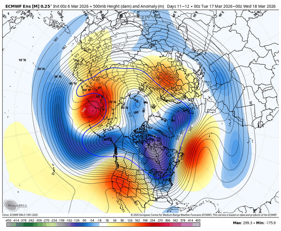
WB 0Z EURO for the 16-17 period. EPS does does have an eastern trough.
-

2025-2026 ENSO
so_whats_happening replied to 40/70 Benchmark's topic in Weather Forecasting and Discussion
Im not sure I understand what he is trying to say here in the bold. -
Over to mostly snow now with a few pellets mixed in
-
Lol pepsi co but the Frito Lay division.. I had to find something up here.. I got sick of driving back and fourth to westfield every day.. mostly do the leominster area.. first stop is bjs this morning put shit up and order its a pretty good gig.. pays well plus get good mileage. benefits are amazing usually out by 12 to 1 and Noone bothers me
-
Never never had a chance here. Always looked like mostly a mixed mess nop with a couple/few well north
-

Central PA Spring 2026 Discussion/Obs Thread
MAG5035 replied to Voyager's topic in Upstate New York/Pennsylvania
0.65” of rain here yesterday. Eastern PA definitely looks to be denied a full torch this weekend as cool air damming, cloud cover and maritime flow off the Atlantic have a firm hold east of the mountains. Meanwhile from the Laurels westward, increasing breezy southwest flow is going to make for much warmer temps, likely making a run at 65-70 or so on Saturday. Sus Valley may eventually mix down 50s to near 60 later Saturday/Sat night as a weak frontal passage approaches. Mon-Wed is the real time frame where it looks quite warm, as it has looked consistently on models for like the last week. Tuesday is the best chance for at least the southern half of PA to make a run at 70ºF ahead of the next system. Some difference between Euro and GFS with the Euro being much more expansive in PA with the very warm temps and GFS more confined to southern PA. Much more uncertainty abound beyond that, big differences between the Euro and GFS. Euro has been way colder around the St Patty’s day timeframe and also has a storm on tonight’s 0z run. GFS bottles up cold air more in Canada and runs a further north storm track. Both models and ensembles develop the really negative WPO, which should put a lot more cold back in Canada. They’re also pretty firm on a pretty positive AO and NAO though, which would suggest cold intrusions into the US are limited and brief. Difference area is the PNA, where the Euro/ensembles (and Canadian) reverses a pretty negative PNA to positive to set up western ridging and a chance at the kind of storm it puts out at 0z tonight and holding a cold pattern more. The GFS op just keeps the PNA solidly negative and its ensembles do reflect the other models more with the reversal but is more neutral. I’m fairly pessimistic overall on any decent snow chances in that timeframe mainly due to the +NAO/AO, but building a western ridge even briefly would at least allow for a window to try to line something up. -
Congrats!
-
24.2° -SN 2.1”/0.28” Looks like sleet mostly won out south of here
-

E PA/NJ/DE Spring 2026 Obs/Discussion
LVblizzard replied to PhiEaglesfan712's topic in Philadelphia Region
Snowpack is officially gone. There’s a shady spot in my yard that still had some remnants left. Today’s rain washed that away. All that’s left now is the pile at the end of my driveway. Overall a very impressive duration, I had snow on the ground there for a month and a half straight. -
Agree Time is ticking
-
about 1.50 inches of rain for nyc.
-
That's our chance, mid month time period. After that it starts getting really dicey climo wise around our area
-
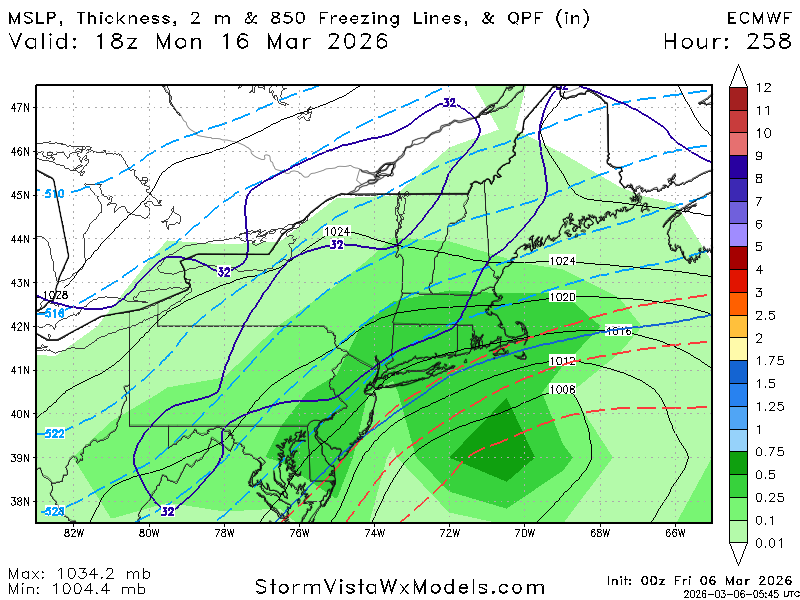
E PA/NJ/DE Spring 2026 Obs/Discussion
RedSky replied to PhiEaglesfan712's topic in Philadelphia Region
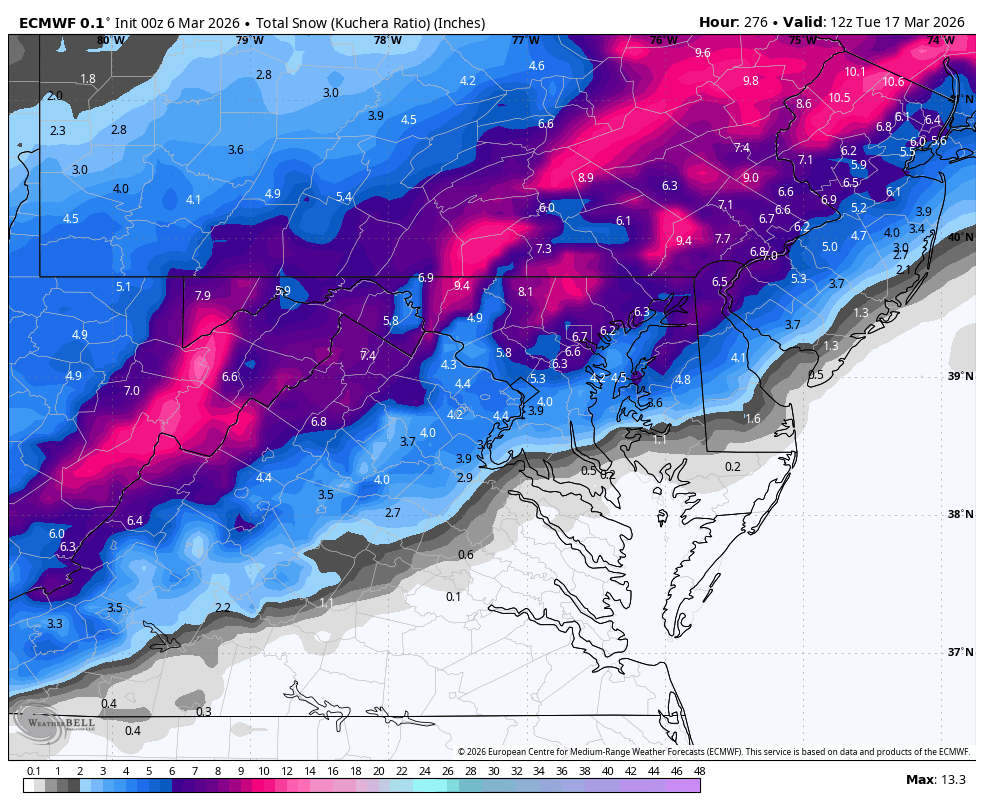
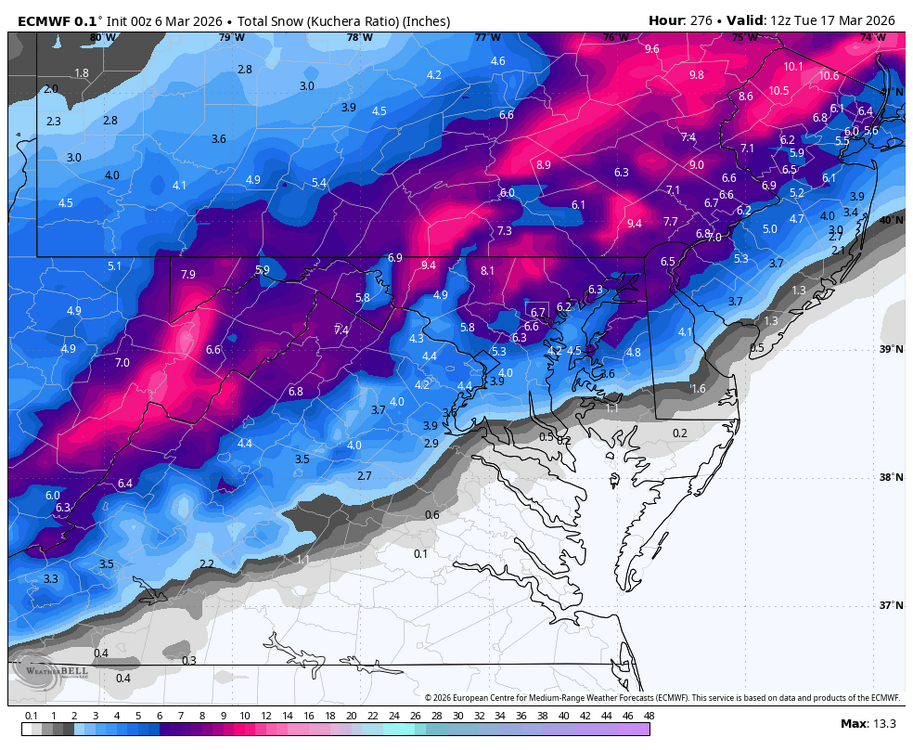
Significant cross polar flow pv attack mid month and snowstorm chance on 0z ECM -
Tell me about it
-
@Damage In TollandI see what Gibbs meant now with the EURO ENSO guidance that came out today...easy winter outlook if that's right. Could still get a biggie in latter January or February, though.
-
-
Let's go !
-
Since I checked, flipped to sleet/zr in the last 10 min pouring