All Activity
- Past hour
-

26th-27th event, coming at us like a wounded duck.
Sey-Mour Snow replied to Go Kart Mozart's topic in New England
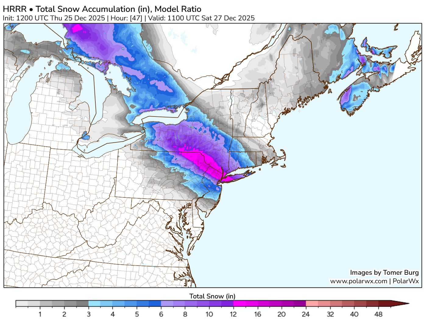
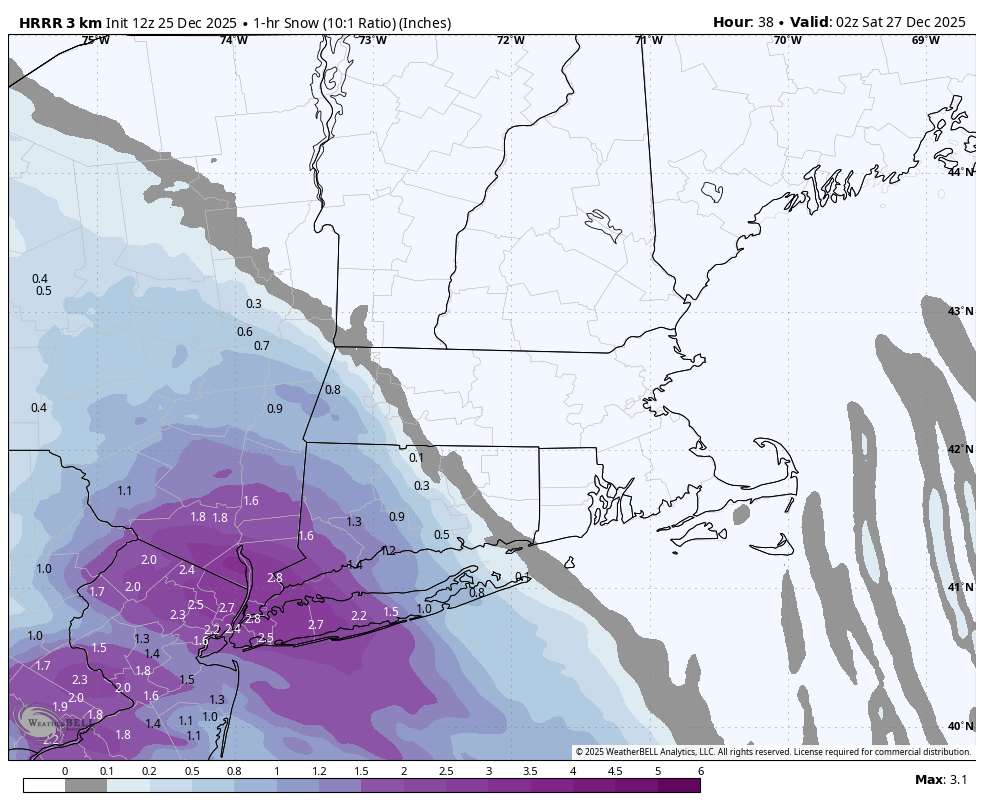
From Tomer.. His model ratio calculates 4-5" per hour over SENY and NNJ in that band lmao
-
26th-27th event, coming at us like a wounded duck.
KTBFFH1905 replied to Go Kart Mozart's topic in New England
We are up in Jay,VT and would love to come home to 4-6 after getting spoiled up here with snow conditions. -

26th-27th event, coming at us like a wounded duck.
weatherwiz replied to Go Kart Mozart's topic in New England
Holy shit..that might rip 2.5-3" per hour with thunder -

26th-27th event, coming at us like a wounded duck.
radarman replied to Go Kart Mozart's topic in New England
Catamount should be skiing well on Saturday. It's been pretty rare for the Taconics to maybe jack a snowstorm in recent years. Possibly an early season event like 3-4 years ago that rained on most of us. -

26th-27th event, coming at us like a wounded duck.
Damage In Tolland replied to Go Kart Mozart's topic in New England
The sleet is going to pound NYC in this set up. People always doubt the NAM… until they don’t -
26th-27th event, coming at us like a wounded duck.
Sey-Mour Snow replied to Go Kart Mozart's topic in New England
You gotta check out modeled soundings for HPN under that mega band on HRRR -
Around 1.5 inches new snow this morning, still -sn this morning, very festive!
-

26th-27th event, coming at us like a wounded duck.
WinterWolf replied to Go Kart Mozart's topic in New England
100% agreed. I’d love to grab 4”…but 6” would really feel good. But conservative is the best approach. -
26th-27th event, coming at us like a wounded duck.
weatherwiz replied to Go Kart Mozart's topic in New England
Where the best of heaviest snow occurs max totals should be upwards of 7-8-9" or so. 10 might be tough just because of how fast the system is moving but it will probably dump 2" per hour under the band for a time. -

Central PA Winter 25/26 Discussion and Obs
mahantango#1 replied to MAG5035's topic in Upstate New York/Pennsylvania
-

White Christmas Miracle? December 23-24th
tamarack replied to Baroclinic Zone's topic in New England
Excellent winter capped by a cold and snowy March that brought the pack to 43". Surprise 0.9" on the board this morning, total now 24.0". -
26th-27th event, coming at us like a wounded duck.
Sey-Mour Snow replied to Go Kart Mozart's topic in New England
I mean plenty of guidance supports 6-8" . I like 4-8/6-10 to give more of a range. We haven't had things break our way in a while, so it's best to stay conservative. Right now north west NYC metro is favored.. -
26th-27th event, coming at us like a wounded duck.
WinterWolf replied to Go Kart Mozart's topic in New England
We still don’t know completely how this is gonna turn out…let’s see how today unfolds. But ya, it’s gonna be tougher way out east. -
Joy to the World! Merry Christmas!
-
A coupled SPV is the last thing we will need. That usually allows the Arctic and northern zones to remain frigid but generally, like 2020 winter, doesn’t allow for any cold air to spill over into the US . Hopefully that doesn’t happen.
-
Over the past few weeks, I’ve talked about how we will need whole scale changes in order to move that death ridge out of the central US and move it briefly over the east and then the pattered can start to reset with a PNA building over the western US, which will lead to heights falling across the east. We have certainly had the cold this winter and we will have more storms too once that PNA establishes itself. With such a large ridge over the central US it’s hard to have much storms aside from the northern stream can produce. Having that PNA is our ticket to bigger when opportunities.
-
26th-27th event, coming at us like a wounded duck.
WinterWolf replied to Go Kart Mozart's topic in New England
Snowman19 just said nothing supports even 6-8 inches there …let alone a foot plus amounts. But ya..let’s get some of that up this way..please. -

26th-27th event, coming at us like a wounded duck.
TauntonBlizzard2013 replied to Go Kart Mozart's topic in New England
Congrats to the CT folks. Hopefully our turn out here sometime this winter. Been a rough half decade for many -
-

26th-27th event, coming at us like a wounded duck.
Kitz Craver replied to Go Kart Mozart's topic in New England
Good for Ant -
26th-27th event, coming at us like a wounded duck.
Sey-Mour Snow replied to Go Kart Mozart's topic in New England
Man thats a Major NYC metro snowstorm, lets pull that NE please.. Verbatim would be 12-17"+ in the jack stripe , what a weenie run -

Snow Potential Dec 26-27
SomeguyfromTakomaPark replied to WeatherGeek2025's topic in New York City Metro
I’m taking the HRRR + globals when the NAM is on its own like this. -
We are less than 36 hours from this event in NYC and the HRRR is showing over a foot of snow (with ratios) and NAM is showing nada. The 12z NAM will be very interesting.
-

Boxing Night Snow/Sleet/Ice Dec 26-27 Storm Thread/Obs.
Ralph Wiggum replied to Mikeymac5306's topic in Philadelphia Region
Thats what I was waiting for. Ty -
26th-27th event, coming at us like a wounded duck.
Sey-Mour Snow replied to Go Kart Mozart's topic in New England