All Activity
- Past hour
-

“Cory’s in NYC! Let’s HECS!” Feb. 22-24 Disco
SouthCoastMA replied to TheSnowman's topic in New England
Yeah everything will be caked..power loss inevitable -
Rain in Brooklyn. This will impact snow totals if rain keeps up
-
As the system starts to occlude, we may see banding widen out a bit for a while. Regardless, I can't wait to watch this evolve
-

Feb 22nd/23rd "There's no way..." Obs Thread
aldie 22 replied to Maestrobjwa's topic in Mid Atlantic
36.3 0.06 rain so far I suspect i should see some mixing in the next hour so -

Feb 22nd/23rd "There's no way..." Obs Thread
MN Transplant replied to Maestrobjwa's topic in Mid Atlantic
Rain. 36.3 -
I’ve seen enough, heading out to get a yardstick. My ruler won’t do for this storm.
-
Snowing here in the bronx.
-
“Cory’s in NYC! Let’s HECS!” Feb. 22-24 Disco
SouthCoastMA replied to TheSnowman's topic in New England
2 successful HECS threads and here for neither. What a sport -
.thumb.jpg.6a4895b2a43f87359e4e7d04a6fa0d14.jpg)
Central PA Winter 25/26 Discussion and Obs
Yardstickgozinya replied to MAG5035's topic in Upstate New York/Pennsylvania
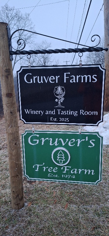
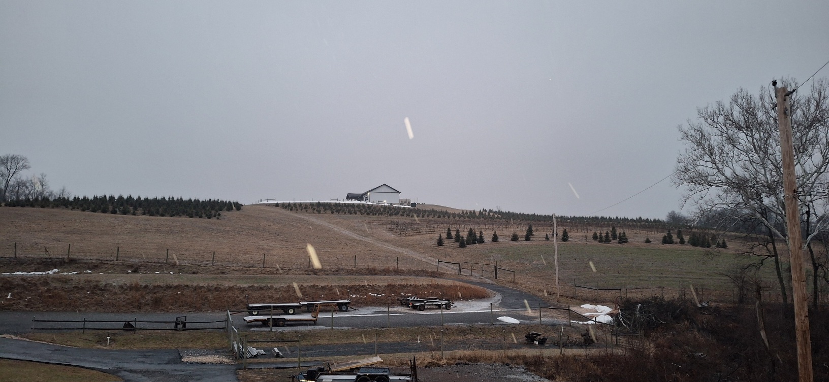
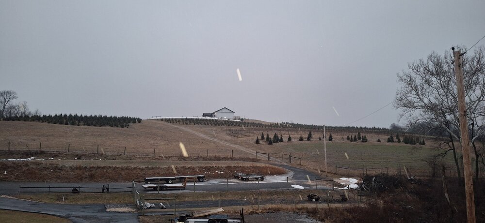
I just had a view back towards some higher elevation and I can definitely tell it's been snowing a little longer up there. It's been snowing rather light here for the last half hour b,ut we're still getting coverage without much of a problem. I know some of you fellows like your wine. This place is basically in my backyard.It's where my son and I cut down a lot of our christmas trees. Back in 09 when my son was still a child he got to experience cutting down a tree in an epic snow snow and drag it home on a sled with me. He's not as fond of snow as his old man, but it's definitely a fond memory of his.
-

Feb 22nd/23rd "There's no way..." Obs Thread
GEOS5ftw replied to Maestrobjwa's topic in Mid Atlantic
The high CC we are seeing everywhere is actually snow above the melting layer (which is very shallow today - anxiously awaiting the 12Z IAD sounding to verify). The lower CC near the radar (where the beam is lowest) is the melting layer which is in the lowest 1500 ft if I'm interpreting Radarscope's beam altitude correctly. We should see that zone of low CC collapse to the radar site as the snow reaches the ground. During the January storm, someone posted time series of quasi-vertical profiles from LWX and other radars. These are an awesome tool to see subtle vertical shifts in melting layer/ptype over time (you give up horizontal resolution for vertical resolution). I can't seem to find a site for these so maybe they were manually generated? Would love to monitor them in real time for this storm. -
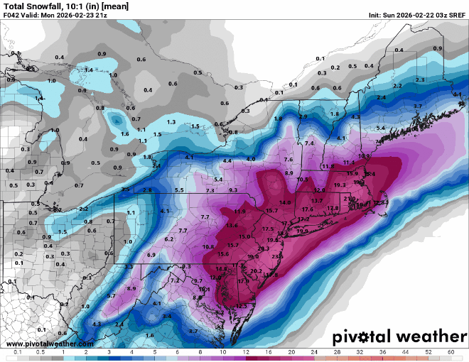
sref is still great for almost everyone, only really impacted the western cutoff, which was wild to begin with had double digits way upstate lol
-

“Cory’s in NYC! Let’s HECS!” Feb. 22-24 Disco
CoastalWx replied to TheSnowman's topic in New England
Yeah let’s shove that to 495 -

“Cory’s in NYC! Let’s HECS!” Feb. 22-24 Disco
HoarfrostHubb replied to TheSnowman's topic in New England
If Cory jacks but he’s not there, does he really jack? That zone around Pawtucket/Foxboro/Brockton could see 36” -
We still get a foot and tour aka Send us a twitter post from October with the raging La Niña.
-
He's trolling don't bother.
-
HRDPS doesn’t even agree with the RGEM
-
Gotcha! Only asked bc I used to work at one in Westchester county NY like 5 miles from home.
-

Feb 22nd/23rd "There's no way..." Obs Thread
SomeguyfromTakomaPark replied to Maestrobjwa's topic in Mid Atlantic
We’ll find out soon who’s right about temps hrrr vs 3k….hoping it’s 3k -

“Cory’s in NYC! Let’s HECS!” Feb. 22-24 Disco
ORH_wxman replied to TheSnowman's topic in New England
You prob don’t want the rotting band if you’re in SE areas because you don’t want to miss the convection t being entrained into the CCB. They’ll be a relative jackpot west with wherever the band pivots but there will be another with the Firehose of convective snows hitting SE areas…they’ll get their own bands taking their time to leave later in the storm too, but the stuff very early tomorrow morning could be epic there. -

Feb 22nd/23rd "There's no way..." Obs Thread
Solution Man replied to Maestrobjwa's topic in Mid Atlantic
Seems very persistent with the IVT, surprises coming -
Light rain. 37/34
-
I’m aware and you will b wrong! 12” is the floor here. Bye for now
-
24 hour Shop Rite in Old Bridge, NJ. I wasn't going to shop yesterday and knew I had to get in early today before it gets super busy again.
-

“Cory’s in NYC! Let’s HECS!” Feb. 22-24 Disco
mahk_webstah replied to TheSnowman's topic in New England
I thought the euro AI looked a bit further south and east but who knows. Also, I’m not sure that’s the right model this close to game time. We just have to hope for the rogue band and a little push north. Zero would truly be laugh worthy. -

Pittsburgh/Western PA WINTER ‘25/‘26
RitualOfTheTrout replied to Burghblizz's topic in Upstate New York/Pennsylvania
Picked up almost 2 inches on the deck. Less on the grass, and nothing on sidewalk / roads. It stuck to all the trees, pretty scene out there til we warm up later.


.thumb.png.991e09c19c25af7391ed569a205a5136.png)