All Activity
- Past hour
-
.thumb.gif.f92b16c631a1d15d405ed77b33f0710d.gif)
Augdewst 2026: Summer's Last Stand
Torch Tiger replied to Prismshine Productions's topic in New England
done
-
Still at 66 as of 1pm. Highest we got was 68 at 7am. The record low maximum temperature is 65 in 1964. With that superMCS going on, may very well be stuck in the mid to upper 60s the entire day today.
-
Very unreal superMCS
-

2026-2027 Record-breaking El Nino
LakePaste25 replied to Stormchaserchuck1's topic in Weather Forecasting and Discussion
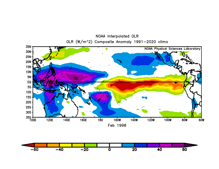
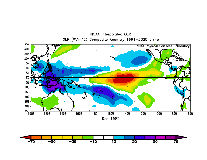
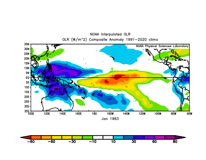
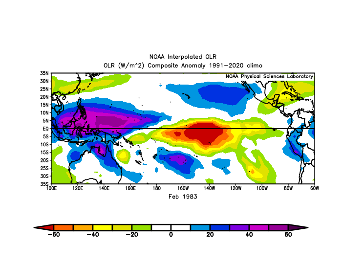
Very subtle but you can see how more dateline forcing shifts the Aleutian Low away from the PNA domain and more equatorward in 1983. Keep in mind it was a colder climate period despite showing a *weaker* low. Obviously the -NAO is a major help here.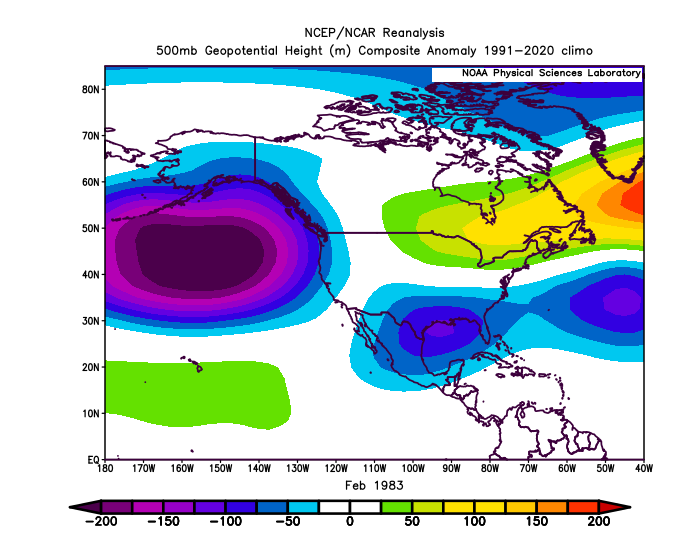
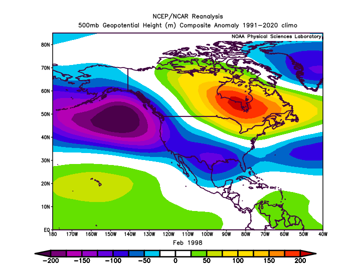
-
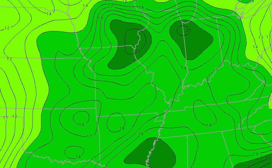
Im really curious to see what the some of the 3 day totals will be in Indiana
-
I only know pain
-
2026-2027 Record-breaking El Nino
LakePaste25 replied to Stormchaserchuck1's topic in Weather Forecasting and Discussion
The forcing was similar but Feb 1983 was more confined to the dateline vs the EPac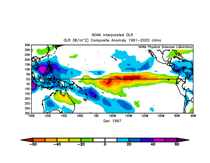
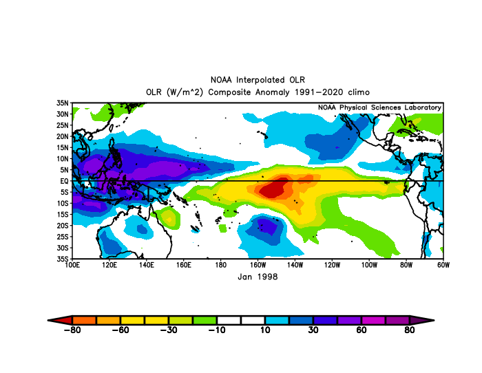
-
Amazing drive into work this morning. Went from dense fog to dark as night driving right into the incoming line. Couldn't see a shelf cause of the fog. Then hit a wall of torrential rains and 60mph winds. Was worrying a bit about some of the trees whipping around on the west side of the highway. Another great soaker with over an inch at home looks like.
-
Everyone becomes Cy Young when they leave the Orioles.
-
I have my long johns on.
-
If we're not going to have any more heat coming, bring on Fall. August this month is just shot.
-

2026-2027 Record-breaking El Nino
40/70 Benchmark replied to Stormchaserchuck1's topic in Weather Forecasting and Discussion
1982-1983 had -EPO and a-WPO....uncharacteristically favorable N Pac. that year...only on in that subset, which is actually an outstanding analog....we just need to keep closing that RONI/ONI delta. 1972-1973 was the worst N Pac. -
2010 and 2016 were the only 2 winters where my old home in Maryland did better than your area.
-
The Green Monster lol. Thats some juice right there...
-
This is the time of year when I get impatient for Fall. So over summer.
-

2026 Atlantic Hurricane Season
WxWatcher007 replied to Stormchaserchuck1's topic in Tropical Headquarters
I ended up creating threads for Cristobal and 92L. Probably going to need one for a future 93L at some point given the models shifting attention to that wave. Not a surprise as often the lead waves end up being sacrificial for the trailing ones in marginal to hostile environments. -
Pretty much a FFE from around Logansport down S of New Castle. Active water rescues and evacuations ongoing throughout the area. Its been raining here since midnight
-
 https://mapletrustrx.shop/# canadian pharmacy online
 -

Augdewst 2026: Summer's Last Stand
powderfreak replied to Prismshine Productions's topic in New England
The description of “Welcome to Logan: Boston’s Urban Asshole” has a nice billboard ring to it. -
Invest 92L--80% two day, 80% five day odds
WxWatcher007 replied to WxWatcher007's topic in Tropical Headquarters
Models are pretty lukewarm for this invest, but AI ensembles, especially the Euro AI, track it into the Caribbean. Shear is an issue across the basin, where it's been historically high in the last month. -
Crazy rainfall totals down in Indiana. Pretty parched here and even worse to my north. 7.03” since June 1st 0.13” since August 1st
-
Again, asleep at the wheel. Here's a thread for Invest 92L, which seems poised to become a TD soon in the central Atlantic. Discuss here. Central Tropical Atlantic (AL92): An area of showers and thunderstorms associated with a tropical wave is located about 900 miles west-southwest of the Cabo Verde Islands. Environmental conditions are forecast to be conducive for development during the next couple of days, and a tropical depression will likely form while the system moves westward to west-northwestward across the central tropical Atlantic. * Formation chance through 48 hours...high...80 percent. * Formation chance through 7 days...high...80 percent.
-
I've been asleep at the wheel. We have a short lived TS in the central Atlantic. Creating a thread for posterity lol. Tropical Storm Cristobal Discussion Number 1 NWS National Hurricane Center Miami FL AL032026 300 PM GMT Wed Aug 12 2026 The circulation associated with the area of low pressure we have been monitoring well east-northeast of Bermuda over the past several days has become better defined today. A recent ASCAT pass revealed an area of 35-40 kt winds southeast of the slightly elongated and exposed center, within the region of convection. While the convective organization has degraded since earlier this morning, scatterometer data indicate that the system has achieved tropical storm status, and it likely reached that threshold earlier this morning. Therefore, advisories are being initiated on Tropical Storm Cristobal, with the initial intensity set to 40 kt. Cristobal is moving quickly eastward around 22 kt over marginally favorable sea surface temperatures near 25 C. The storm is currently positioned between a subtropical high to the south, and a ridge extending over the north-central Atlantic to the northeast. A turn toward the northeast, accompanied by a gradual decrease in forward speed, is expected later today and tonight as Cristobal moves along the southwestern periphery of the northern Atlantic ridge. Slow weakening is forecast during this period as the storm moves over progressively cooler waters and encounters increasingly dry mid-level air and stronger northerly wind shear. Cristobal is expected to be short-lived and dissipate on Thursday. The official NHC track and intensity forecasts lie near the middle of the consensus guidance and are closest to the HCCA solution. FORECAST POSITIONS AND MAX WINDS INIT 12/1500Z 36.7N 43.0W 40 KT 45 MPH 12H 13/0000Z 37.4N 40.2W 35 KT 40 MPH 24H 13/1200Z 38.5N 37.2W 30 KT 35 MPH 36H 14/0000Z...DISSIPATED $$ Forecaster Adams/Cangialosi
- Today
-
Miss near south
-
Trying to will the bow echo just far enough north to get the shelf cloud. What a run we're on.