All Activity
- Past hour
-

2025-2026 ENSO
40/70 Benchmark replied to 40/70 Benchmark's topic in Weather Forecasting and Discussion
Should happen again. -

December 2025 regional war/obs/disco thread
WinterWolf replied to Torch Tiger's topic in New England
I’m still waiting for any blocking to help us here…lately it’s been hurting us rather than helping. Let’s hope this time it can be our Allie. -
Gonna see a lot of guidance changes in the day or two IMHO for next week…you have that pig ridge in the central CONUS but it’s flat and somewhat zonal so little disturbances are FLYING across the country in the flow….makes for decent model chaos. On top of that you have some blocking trying to form in the Atlantic which adds in more uncertainty.
-
At first look it seems the Euro and GFS are far apart, but they really aren't. Seems the GFS is sensing more of a cold press. That seems to be the theme this season so far, mute the warm ups
-
2025-2026 ENSO
40/70 Benchmark replied to 40/70 Benchmark's topic in Weather Forecasting and Discussion
Yea, lovely- -
Gotta watch 12/23-24 too for a little disturbance. Obviously there’s the Xmas day threat too but not every model agrees on timing.
-
Blocking keeps showing up on the modles which is great.
-
December 2025 regional war/obs/disco thread
WinterWolf replied to Torch Tiger's topic in New England
Off hour runs to the rescue…however it was the off hour runs that kept Sunday alive all last eeek, and they were right. So there’s that. -

E PA/NJ/DE Winter 2025-26 Obs/Discussion
Mikeymac5306 replied to LVblizzard's topic in Philadelphia Region
Needs to drop about 50-75 miles south and we got "something" per 6z -
If I had a hundo for every time I heard that! But, I did see it happen... ONCE haha. I actually have it on video somewhere, probably about 1987. Golf ball flakes for about 10 minutes, about how long the old video recorders could hold a charge lol
-

December 2025 Short/Medium Range Forecast Thread
Carvers Gap replied to John1122's topic in Tennessee Valley
Kind of wild in the wx model world at 0z and 6z. The 6z GFS cuts into the Chinook lifespan fairs significantly. IF the NAO is a realistic player, it is likely going to turn the pattern after 240 upside-down. It sure did last night on several runs. -
All we can say is that the first 16 days of December have been one of our coldest 16 day periods relative to the means of the 2020s so far. The clipper was a nice contribution to this period feeling very wintry around the area. This was actually the coldest first half of December in 20 years. The new Newark records for December now go back to 1850. So this was ranked 26th coldest which is very respectable in our warmer 2020s climate. The current 7 station departure across the area is -7.7. With the moderation coming up next few weeks, the final number this month may finish in the -3 to -4 range. Models have been fluctuating from run to so we won’t know the exact number for a weeks. EWR…..-8.1 NYC……-8.7 LGA……-8.7 JFK…….-7.8 HPN……-7.6 BDR…...-7.9 ISP……..-5.4 AVG…….-7.7 Time Series Summary for NEWARK LIBERTY INTL AP, NJ Coldest 12-01 to 12-16 periods Click column heading to sort ascending, click again to sort descending. 1 1867-12-16 24.1 5 2 1904-12-16 24.6 0 3 1910-12-16 25.5 0 4 1917-12-16 25.7 4 5 1876-12-16 27.0 5 6 1868-12-16 27.3 3 7 1958-12-16 27.9 0 - 1871-12-16 27.9 1 8 1902-12-16 28.6 0 9 1989-12-16 28.8 0 - 1869-12-16 28.8 4 10 1860-12-16 28.9 2 11 1880-12-16 29.0 3 12 1895-12-16 29.1 2 13 1859-12-16 29.4 4 14 1886-12-16 29.5 4 15 1882-12-16 29.7 2 16 1915-12-16 29.8 1 17 1903-12-16 30.0 0 - 1872-12-16 30.0 2 18 2005-12-16 30.4 0 19 1976-12-16 30.6 0 20 1854-12-16 30.8 3 21 1898-12-16 31.0 0 22 1937-12-16 31.1 0 23 1942-12-16 31.2 0 24 1875-12-16 31.4 0 25 1851-12-16 31.7 4 26 2025-12-16 31.8 0 - 1945-12-16 31.8 0
-
December 2025 regional war/obs/disco thread
WinterWolf replied to Torch Tiger's topic in New England
Ya drive them yourself…let the snow come. We beggars..we need anything we can get . Fire up the Ram! -
December 2025 regional war/obs/disco thread
WinterWolf replied to Torch Tiger's topic in New England
OMG…truer words were never spoken lol. And the one time it might, it was literally for about a minute to a minute and a half…maybe 10 flakes lmao…what a joke. Great recall United. -
Lets keep those systems away from Christmas day! Get that Eve wave in early, and keep the second one for Christmas night! We're having our first big family GTG in a while and don't want people to cancel. Shit, I'll fill up the Power Wagon and drive them myself LOL
-

Central PA Winter 25/26 Discussion and Obs
mahantango#1 replied to MAG5035's topic in Upstate New York/Pennsylvania
-
Unfortunately the Aleutian ridge doesn’t really disappear it just retrogrades west moving the MW high axis just west enough for our -NAO, a fickle look with raging -PNA but at least some positivity. Given base state with pacific id be worried this would remain a progressive pattern and any cold shot/winter weather opportunity would be limited in duration and thus somewhat unlikely even if we end up cold around new years.
-
And unfortunately, those strong La Niña are often a coin toss between whether there is above average snowfall in New York City or well below average snowfall in New York City. Looks like the active weather pattern will continue across for northern US and put the south and the central US states will remain warm and dry. Usually it does not bode well for the mid Atlantic when there’s only an active northern stream and the southern stream is relatively muted. That doesn’t prevent coastal storms or the big bowling ball storms and most of us need to produce meaningful snow. For New England an active northern stream is conducive for snowfall, but for most of us absolutely is not. The long range models show no signs of this pattern, letting up. There will likely be no chances for snowfall for most of us in the foreseeable future going out through at least early to mid January.
-

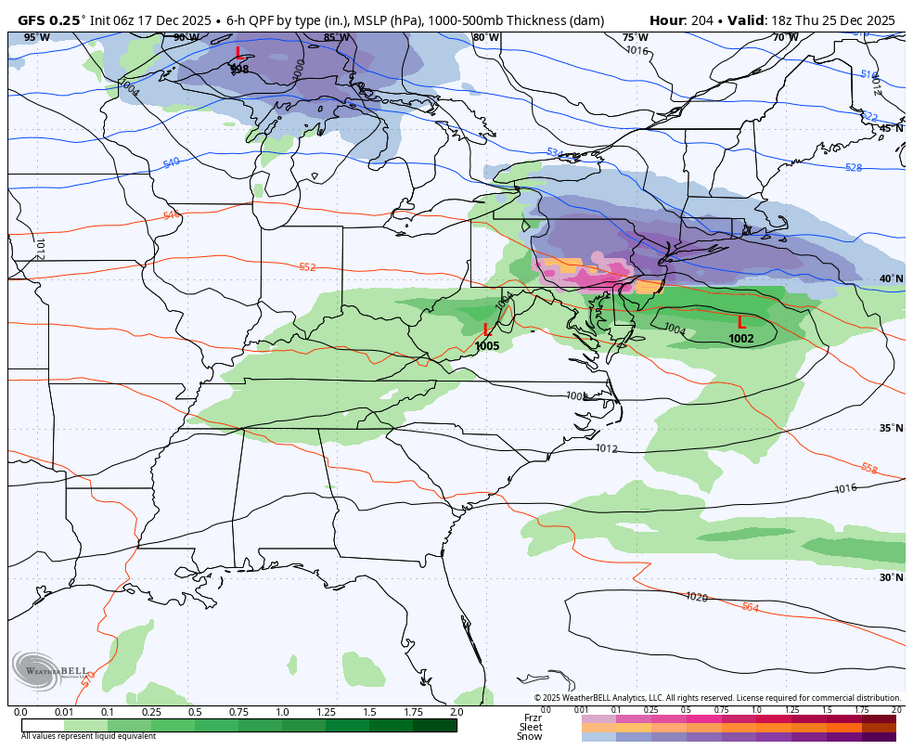
Central PA Winter 25/26 Discussion and Obs
Blizzard of 93 replied to MAG5035's topic in Upstate New York/Pennsylvania
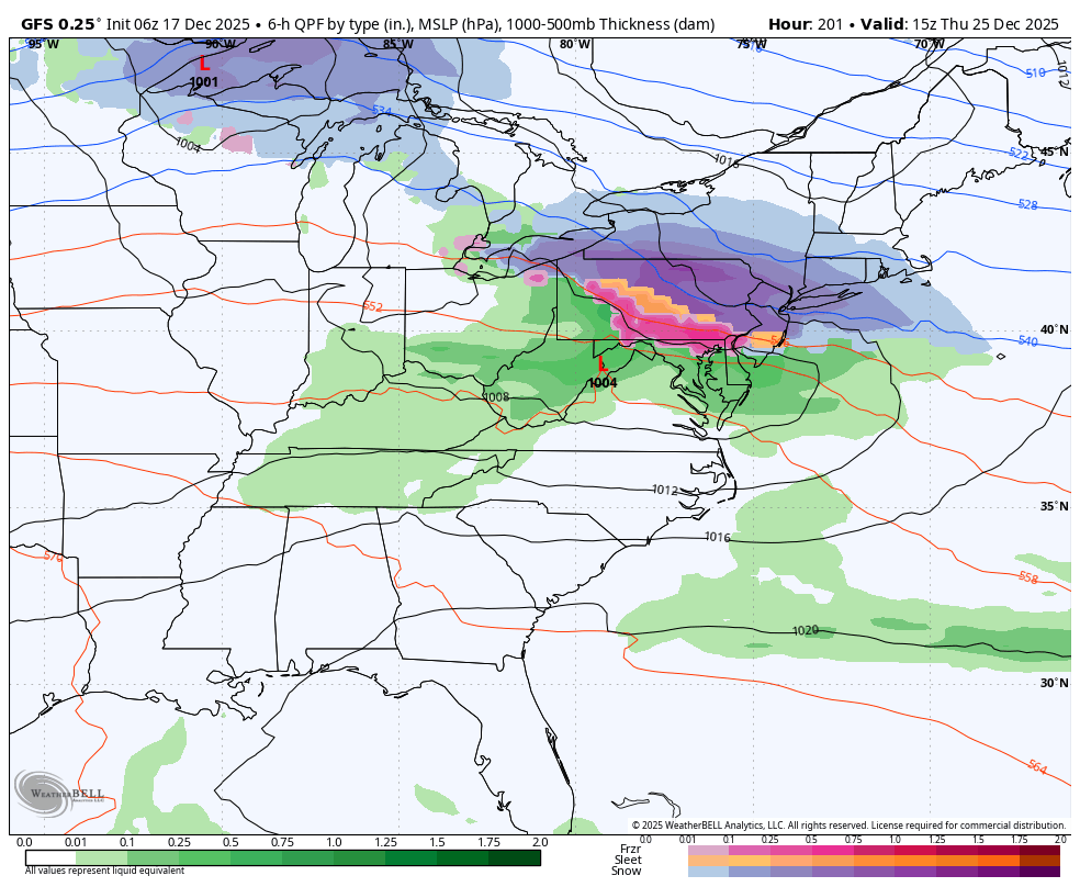
0z & 6z GFS both showed potential for Christmas wintry weather with a possible icy mix & snow for most of CTP. The Canadian last night had a mix as well. The Euro was not on board. Here is the 6z GFS for Christmas.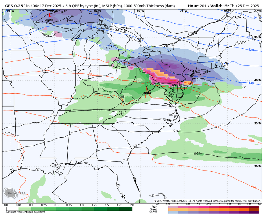
-
"Rain changing to snow before ending" The weather call of the 80s... that 99.725% of the time never happend
-
Can we please make this a thing. Thanks.

-
Central PA Winter 25/26 Discussion and Obs
mahantango#1 replied to MAG5035's topic in Upstate New York/Pennsylvania
https://www.timeanddate.com/countdown/spring -
Some pretty positive changes on ensembles overnight regarding NAO tanking after Christmas just before new years.
-

Central PA Winter 25/26 Discussion and Obs
Voyager replied to MAG5035's topic in Upstate New York/Pennsylvania
I'm thinking we warm for the holiday weeks when I have multiple days off. Then, come January, when it's back to regular work weeks, we tank again. It's just my luck... -
That's the next step...I haven't determined the when yet but it's getting closer every day