All Activity
- Past hour
-
CoCoRaHS for July 3 to today shows widespread 7-9 plus inch amounts in southern MoCo and 4-6 inches around Gaithersburg, compared to 0.8 here. What an incredible micro-climate desert this place is, and it's not just this year. This is normal. What a tough place to try to have a gardening hobby.
-
Based on hourlies, it’s possible that either or both of Augusta and Columbia had lows of 80. If so (we should know later this morning) and if convection doesn’t bring lower temps than 80 the rest of today, this would mean: -at Augusta (Bush) it would tie the warmest low for any date since 1945 and would be the warmest July low since 80 in 1990 -at CAE it would tie for the warmest July low since 1893
-

July 2025 Obs/Disco ... possible historic month for heat
Damage In Tolland replied to Typhoon Tip's topic in New England
Solid look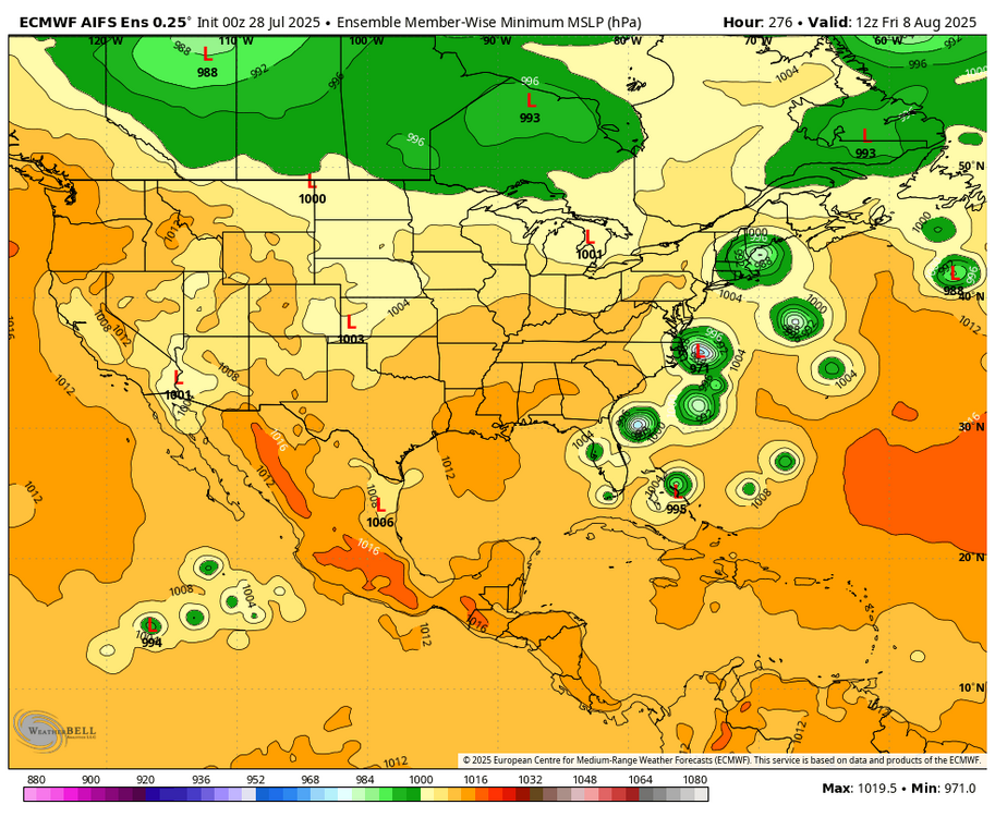
-

July 2025 Obs/Disco ... possible historic month for heat
jbenedet replied to Typhoon Tip's topic in New England
Hoping this fog sticks for a chunk of the day. Pleasant surprise this morning. Anything to eliminate another potential HHH weekday. -
July 2025 Obs/Disco ... possible historic month for heat
Damage In Tolland replied to Typhoon Tip's topic in New England
Much more interested in the cane coming up next week than phantom Euro heavy rains in summer with convection ribbing moisture transport. -
So far MJO phases phases 5-6-7 have been heavily favored. The difference between this year and last year is that the forcing hasn’t been as strong/amplified
-

July 2025 Obs/Disco ... possible historic month for heat
CoastalWx replied to Typhoon Tip's topic in New England
Something his wife has never seen before. -
Unfortunately, it also now appears that flood concerns are elevated on Thursday: .LONG TERM /THURSDAY THROUGH SUNDAY/... Models show t-storms accompanying the southeastward moving front through CPA on Thursday. A wave of low pressure is now progged to move along the boundary, which has trended slower with its southward/southeastward progression. There also appears to be some enhanced large scale lift to support +RA in the form of right entrance region (RER) upper jet dynamics. High rain rates combined with ample deep layer moisture will continue to support an excessive rain/flash flood risk particularly across the southern tier of CPA on Thursday/D4. The slower southward movement may also delay north to south clearing, and we can`t rule out a stray shower lingering early Friday morning in southern tier/far southeast PA. That said, much of the area will be firmly in the dry/cooler sector by Friday afternoon. Behind the front, a comfortably cooler and refreshing airmass (much lower humidity) is poised to arrive just in time to begin the month of August. Slightly below average daytime highs 70-80F and lows 50-60F are forecast along with no rainfall through the first weekend of August. Dewpoints will plummet into the
-
CTP mentioned this morning that the SE counties will see Heat Indexes approach 100 today...the criteria for an advisory being issued is over 100. I suspect that the LSV will see advisories tomorrow and Wednesday. Also - they used the words "fall like weather" when looking ahead to the end of the week.
-

July 2025 Discussion-OBS - seasonable summer variability
bluewave replied to wdrag's topic in New York City Metro
Another longer range modeling underestimation of the Southeast Ridge which has been a frequent occurrence last decade. -

July 2025 Discussion-OBS - seasonable summer variability
winterwarlock replied to wdrag's topic in New York City Metro
https://forecast.weather.gov/showsigwx.php?warnzone=NJZ010&warncounty=NJC035&firewxzone=NJZ010&local_place1=Belle Mead NJ&product1=Heat+Advisory&lat=40.465&lon=-74.6456 There is a heat advisory thru 8pm Wednesday -

July 2025 Discussion-OBS - seasonable summer variability
donsutherland1 replied to wdrag's topic in New York City Metro
Despite a cool start, August will likely be warmer than normal overall. There will be additional opportunities for 90+ heat especially after the 10th. -
76 degrees with 100% humidity this morning. Swampy.
-

July 2025 Discussion-OBS - seasonable summer variability
wdrag replied to wdrag's topic in New York City Metro
No thread from me on Tue-Fri til the last minute (Tue morning?). GFS MOS seems a little cool on the maxes Tue and Wed and too low on chance of rain Thu, maybe Fri too. GEFS coming up on qpf now... all ensembles under 2.5" but the EC OP Max #'s are interesting the past two cycles (isolated over 7" location-location?) -

July 2025 Obs/Disco ... possible historic month for heat
kdxken replied to Typhoon Tip's topic in New England
7 inches for Ditty. -
July 2025 Obs/Disco ... possible historic month for heat
CoastalWx replied to Typhoon Tip's topic in New England
925 winds are briefly NE this morning hence the low clouds backing in from the NE. So definitely cooler on the coast vs 128-495. -
The only weather office along the entire eastern seaboard from New Hampshire to Florida without heat advisories/warnings is LWX. We’re used to suffering so our criteria is too high.
-
July 2025 Discussion-OBS - seasonable summer variability
winterwarlock replied to wdrag's topic in New York City Metro
It was just last week where peeps were saying big heat was done for the year -
This is highly highly disturbing Hundreds of documents show how researchers failed to notify officials in California about a test of technology to block the sun’s rays — while they planned a much huger sequel. https://www.politico.com/news/2025/07/27/california-sunlight-dimming-experiment-collapse-00476983
-
CoCoRaHs totals will be added sometime late this morning.
-
Very strong La Niña background state continuing with the record July heat and Southeast Ridge. So a continuation of these record subtropical ridges. The models have frequently been underestimating the heat and ridging in the East.
-
They are kind of quiet this morning. 67 for the low.
-
July 2025 Obs/Disco ... possible historic month for heat
CoastalWx replied to Typhoon Tip's topic in New England
Ken will be referencing runway 090 for Logan today when back bay is 92. -
July 2025 Obs/Disco ... possible historic month for heat
CoastalWx replied to Typhoon Tip's topic in New England
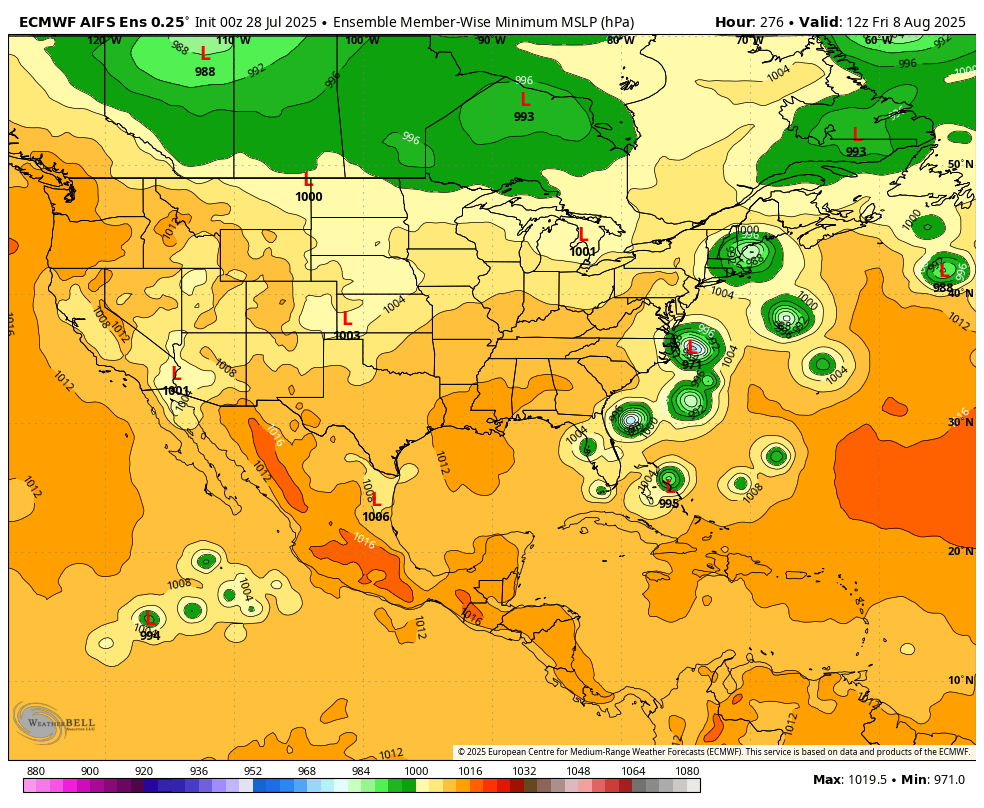
Euro with a sultan signal on the 00z run for later Thursday into Friday. Decent EPS signal too. -

2025-2026 ENSO
40/70 Benchmark replied to 40/70 Benchmark's topic in Weather Forecasting and Discussion
I don't. I try to call BS when I think they are wrong, as I did last year when they bailed on cool ENSO. I am confident they are too meager with it yet again.