
All Activity
- Past hour
-
82 / DP 73 looking mainly dry today and mostly sunny perhaps a bit of an overperformer for warm spots. Day 4 of the heatwave for some. Overall warm - hot through THu before cold front / trough builds into the northeast by Friday 8/14 with near / below normal till around 8/17. Ridge builds back east and next warmup and heat potential in the 8/19 - 8/22 or 23 window. Overall looking warmer than normal beyond there and see if any tropical activity can pick up and kick in.
-

Augdewst 2026: Summer's Last Stand
Damage In Tolland replied to Prismshine Productions's topic in New England
I don’t expect to get much severe here. Not like NW / SW CT who are better positioned. But I do expect to get a few tstorms in an active summer. I mean when Groton to Cape Cod report severe and wind damage several times and I can’t even get a t shower ,it’s just bad luck i guess -

Augdewst 2026: Summer's Last Stand
Lava Rock replied to Prismshine Productions's topic in New England
Naples picked up 1.79". It was just pounding. Sent from my SM-S921U using Tapatalk -

Augdewst 2026: Summer's Last Stand
CT Valley Snowman replied to Prismshine Productions's topic in New England
I thought yesterday pretty much performed as expected. Slight risk over central and western areas where there were some warned cells and a few towns got hit hard while most of us did not. It's just not easy to get widespread severe around here. Most of the time, you just need to get lucky. -
Augdewst 2026: Summer's Last Stand
Damage In Tolland replied to Prismshine Productions's topic in New England
I was thinking about the exact precision I have missed storms this summer. Every direction , every surrounding town really. Union area up to Sturbridge multiple times, S and SE of here . Ginx to Se CT. Hartford got crushed Friday night, BDL all summer , all of western and SW CT and Springfield last night. And now Stein drops the Roman helmet to suffocate -

Central PA Summer 2026 Discussion/Obs Thread
Mount Joy Snowman replied to Voyager's topic in Upstate New York/Pennsylvania
Low of 71 with .15” of rain. Been quite a four day stretch here. Today looks like a perfect river day, might have to hit it. -

Augdewst 2026: Summer's Last Stand
CoastalWx replied to Prismshine Productions's topic in New England
He’s here for awhile. The summer of no storms continues. But I’ll take the sun. -
Our 100° days have been occurring earlier than in the past. Spots in NJ had their earliest 100° day back on May 19th-20th. No 100° days after August 10th during the 2020s. We haven’t had a 100° day after August 10th since 2005. Maximum 1-Day Mean Max Temperature for HARRISON, NJ Earliest and Latest in Bold during the 2020s Click column heading to sort ascending, click again to sort descending. 1 106.0 2026-07-03 2 103.0 2026-07-04 - 103.0 2025-06-25 - 103.0 2025-06-24 3 102.0 2025-07-30 - 102.0 2022-07-25 4 101.0 2025-07-31 - 101.0 2024-07-17 - 101.0 2022-08-10 - 101.0 2022-07-24 - 101.0 2021-06-30 5 100.0 2026-07-02 - 100.0 2026-05-20 - 100.0 2025-07-26 - 100.0 2025-06-26 - 100.0 2024-08-02 - 100.0 2024-06-22 - 100.0 2022-07-23 - 100.0 2021-07-01 Time Series Summary for NEWARK LIBERTY INTL AP, NJ 100° days after August 10th Click column heading to sort ascending, click again to sort descending. 1 1953-09-30 5 0 2 1993-09-30 3 0 3 1948-09-30 2 0 - 1944-09-30 2 0 4 2005-09-30 1 0 - 2002-09-30 1 0 - 1973-09-30 1 0 - 1949-09-30 1 0 - 1881-09-30 1 0
-
Well clouds actually thwarted the heatwave. Had hit 93 and 94 but only 89 yesterday so have to restart today and hope Tuesday can complete the deal
-
 https://sildoliko.shop/# Order Viagra 50 mg online
 -
sildenafil over the counter Cheap Viagra 100mg - buy Viagra online
-
Augdewst 2026: Summer's Last Stand
Damage In Tolland replied to Prismshine Productions's topic in New England
Looks like some smoke up there today. -
 Yes, there is earlier data, but its not Tmin and Tmax, its 7 AM, 1 PM, and 9 PM. csv attached. PA_West_Chester.metadata.csv PA_West_Chester.data.csv
 - Today
-
cialis for sale - [url=http://tadaliko.com/#]Buy Cialis online[/url] Tadalafil price
-
Another needed storm complex missed us to the south. Daily precip chances keep things interesting at least.
-
People underestimate how strong the Urban Heat Island effect is here. Got to be one of the most drastic in the country.
-
Quiet cool morning here in IKK
-
Fair lol still beautiful
-
Counterpoint, beautiful calm morning but doesn't feel juiced to me, airmass ain't it yet
-
Augdewst 2026: Summer's Last Stand
Damage In Tolland replied to Prismshine Productions's topic in New England
Hopefully something pops up that models aren’t seeing -

2026-2027 Record-breaking El Nino
GaWx replied to Stormchaserchuck1's topic in Weather Forecasting and Discussion
Follow-up: Today’s SOI is -10, which makes the current streak at an amazing 91 days, 2nd only to 1998’s 100 days for longest on record back to 1991. I’m predicting that tomorrow’s will be a +SOI, which would mean the streak ends at 91 days. -

Augdewst 2026: Summer's Last Stand
dendrite replied to Prismshine Productions's topic in New England
Why stop at 10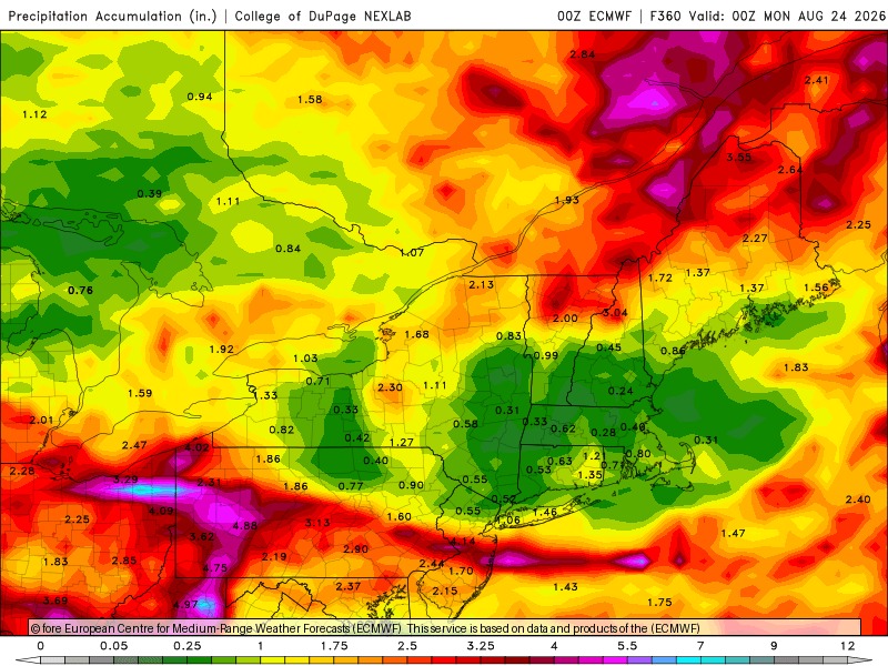
-
Augdewst 2026: Summer's Last Stand
CoastalWx replied to Prismshine Productions's topic in New England
Blue hill which we know how pristine their records are, show you how warm we have been. Another AN summer is locked despite a strong Nino. That’s just what we do now. We embrace CC. -
Augdewst 2026: Summer's Last Stand
Damage In Tolland replied to Prismshine Productions's topic in New England
You could make a case that it’s dry thru the next 10 days. Maybe a shower Thursday -
Augdewst 2026: Summer's Last Stand
CoastalWx replied to Prismshine Productions's topic in New England
Aside from 100sq miles in CT, he’s been around just waiting to pounce from behind the trees.








