All Activity
- Past hour
-
SPOT ON!!!
-

First Legit Storm Potential of the Season Upon Us
Layman replied to 40/70 Benchmark's topic in New England
Since this storm is gone...I don't necessarily feel like I'm derailing the thread by asking: Do you have experience or knowledge about how the AI models are attempting to assimilate data and/or generate output? My very limited understanding is that they're supposed to "learn" but what are they learning from? Historical data? Current data? Compared to other model outputs? Or, comparing after the fact, what actually happened? Curious about all this but not even sure where to look for a quality resource that may explain some of these things. -

January 2026 regional war/obs/disco thread
ORH_wxman replied to Baroclinic Zone's topic in New England
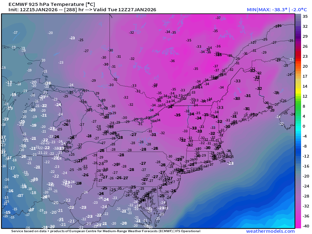
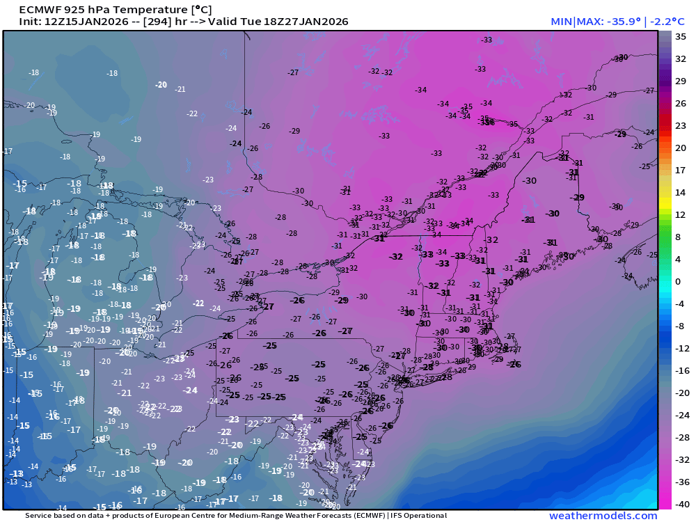
Ok these are the cold events that @dendrite and I like to track. Cold worth tracking. Pure clown range fantasy but it’s so anomalous bits worthy posting…. Not sure I’ve seen -30C at 925 over such a large area. This would be almost perfect too if the timing happened this way because you wouldn’t get the cheap midnight high. Real push arrives between 00z-06z and its so strong that we get like a Xmas 1980 type daytime with highs near -10F even over interior SNE.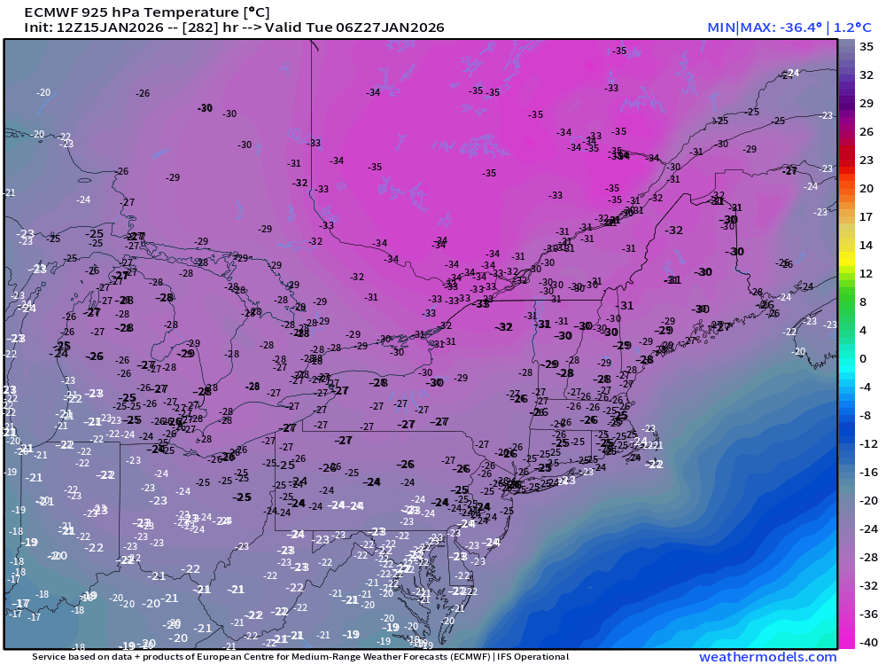
-
Buddy I wish I was in the mountains lol. I’m in a hellscape called the foothills which only uptrends for 1,000 year flood events. I’m legitimately rooting for you guys - sorry if my initial comment seemed like I was ignoring our Deep South posters. It wasn’t my intention. I do have legitimate concerns forum wide that this setup could be hard to deliver on because of the now ever so marginal cold air. And no, nothing wrong with bias, we all have it. It could uptrend or downtrend for any of us.
-

First Legit Storm Potential of the Season Upon Us
Sey-Mour Snow replied to 40/70 Benchmark's topic in New England
I mean the EURO op and EURO AIFS look nothing alike for Sunday at 500…. -
Hush you
-
The EPS actually went west at 12z compared to 6z I think lol
-
(002).thumb.png.6e3d9d46bca5fe41aab7a74871dd8af8.png)
E PA/NJ/DE Winter 2025-26 Obs/Discussion
ChescoWx replied to LVblizzard's topic in Philadelphia Region
Kind of wild but that 12z European model has assuming snow cover a day next Monday with a day that the high may struggle to get above zero. A day below zero has only occurred 1 time in Chester County since 1894! -
this is the Chuck storm. He has been gooning at this window for a 1-2 weeks now
-

First Legit Storm Potential of the Season Upon Us
CoastalWx replied to 40/70 Benchmark's topic in New England
The only thing I heard is that the euro AI ensemble seems to have the best scores in terms of 500 MB. But you and I both know that doesn’t necessarily translate to better and more accurate forecast for sensible weather. -
Yeah, another fantasy storm that will turn out be nonexistent, maybe snow showers. Seems to be the music this year.
-
Jerk
-
That long of a wait? Damn.. we're kicking that can again...
-
First Legit Storm Potential of the Season Upon Us
CoastalWx replied to 40/70 Benchmark's topic in New England
Even the euro AI ensembles got more bullish. This is ridiculous lol. Gotta think they crumble soon. -

E PA/NJ/DE Winter 2025-26 Obs/Discussion
RedSky replied to LVblizzard's topic in Philadelphia Region
Two consecutive runs of the euro with decent snow GFS will have none of it -
"It's become like a piece of furniture Guss"
-
Euro is snowy and active in the mid to long range.
-

First Legit Storm Potential of the Season Upon Us
40/70 Benchmark replied to 40/70 Benchmark's topic in New England
Sweets, lets bury Jordan's box on Belicheck's beach side bungalow in ACK, and keep bare ground in Methuen. -
@stormtracker please tell us youre keeping notes
-
I’ll take the 5 dollar biggie bag please.
-
Increasing optimism. Remember, this is a Wendy's.
-
https://x.com/brady_wx/status/2011850116487893414?s=46&t=LVg8BRWCh1zZb6F_t95EVg .
-
I’m not familiar with these two mods but…. .
-

First Legit Storm Potential of the Season Upon Us
weatherwiz replied to 40/70 Benchmark's topic in New England
This should be pinned at the top of the board As I've also mentioned before, AI can probably be very useful in the nowcasting department or short-term (6-12 hours) but beyond that...a very long ways to go -
First Legit Storm Potential of the Season Upon Us
ORH_wxman replied to 40/70 Benchmark's topic in New England
EPS actually looked slightly better vs 00z…that isn’t saying much though. But it gets 1-2” to south shore area and Cape.


