All Activity
- Past hour
-
IF you're looking for early trends today on model guidance...if you want colder, the first ingredient is get that initial cold push on Monday stronger....if we can drive that -10C 850 line down toward the south coast 12z-18z Monday, then you are looking at a colder profile. But if it gets hung up in CNE, you're gonna see that marginal airmass issue quickly develop on the coastal plain.
-

December 2025 regional war/obs/disco thread
Ginx snewx replied to Torch Tiger's topic in New England
Wut? I see isothermic dump showme your better vertical resolution 6 z Euro. Deets!!! -
Just can’t afford much north ticks. But definitely could be a more widespread paster than we’ve seen recently.
-
Phase 8 for December
-
I have been right so far about than you have. Who am I listening to ? Your quacks aren't posting nonsense.
-

Nov 28-30th Post Turkey Day Wintry Potential
A-L-E-K replied to Chicago Storm's topic in Lakes/Ohio Valley
This is your moment -
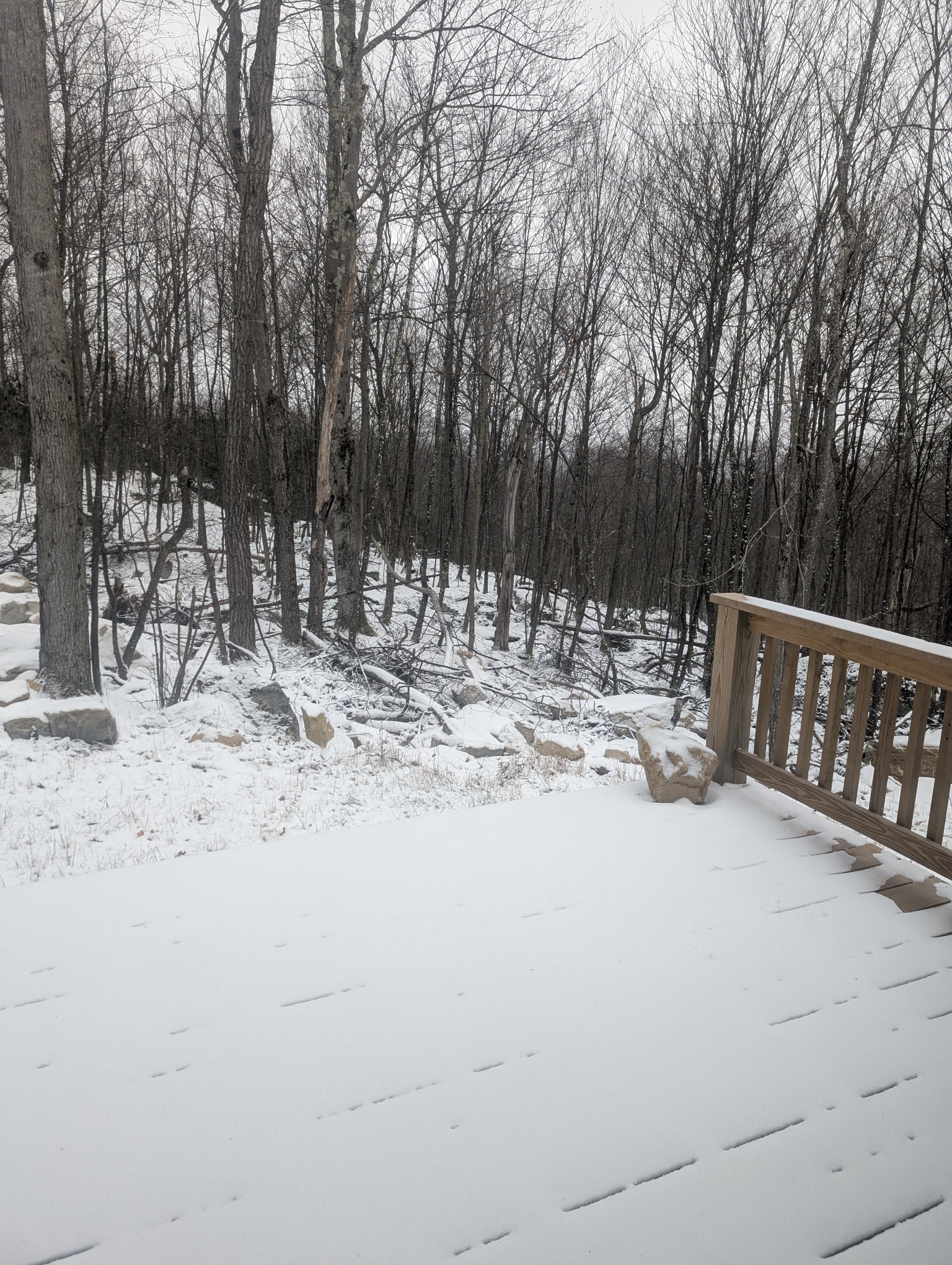
About an inch overnight. Wind is relentless, 21F with wind-chill of 5F.

-

December 2025 regional war/obs/disco thread
WinterWolf replied to Torch Tiger's topic in New England
The same eyor’s are back. As we knew they would be. The take away as John(FXWX) said…it’s an active wintry looking pattern for December. And that’s a good thing. Can’t ask for much else on 11/28. We take and appreciate. -
I do think breaks are coming but there are always going to be MBY screw jobs. And the reality is eastern Mass and the I-95 corridor from sw CT north is always chancy even in a good pattern....
-
Those soundings have terrible vertical resolution. It’s warm for you. Humpy for Hubby.
-
Yeah I think Kevin over to me is like 50/50 right now for pretty good paste job (even if some mix gets in there eventually). Ray’s extra latitude makes him a little better odds. Obviously like ORH (esp northern half of county) up into monads are looking really good if we’re talking SNE zones.
-
December 2025 regional war/obs/disco thread
Ginx snewx replied to Torch Tiger's topic in New England
Not for my soundings unless the .2 at 1000 mb counts. Total paste job. Hopefully 6z Euro is correct. Humpy my name is Thumpy. Wash those minor levels out with 3 per hour stuff -
December 2025 regional war/obs/disco thread
Ginx snewx replied to Torch Tiger's topic in New England
Grow a set. You have been around long enough to get your balls busted without feeling hurt. Jesus -

Nov 28-30th Post Turkey Day Wintry Potential
hawkeye_wx replied to Chicago Storm's topic in Lakes/Ohio Valley
The CAMs were already holding steady with the high-end snow totals and now the lower models are coming up. This is looking like maybe a 10" floor for my area. -

December 2025 regional war/obs/disco thread
weatherwiz replied to Torch Tiger's topic in New England
This will probably really crank under the heaviest banding, but outside of the heaviest banding it may be quite a struggle. I would presume that overall snowgrowth zone will be relatively high and majority of the lift is going to be centered within the 925-800mb layer. So if you're under the heaviest banding...it's going to rock. But not under the banding, it will be a totally different story. -
And 850
-
23 this morning
-
Its still not prime climatological time for snow anyways. Mid December on and it's game time. Hopefully the pattern will stick around and the Pacitic won't come screaming in like the past 5 years.
-
Excited for another Harbaugh press conference (maybe this even was last night?) where he does word salad about having a good game plan and just needing to execute and that the other team is full of professionals that made plays and they need to make plays too and the offensive line actually looked good when they evaluated it.
-
925 is above zero where is gives 12”. Tossed.
-
First Winter Storm to kickoff 2025-26 Winter season
Ginx snewx replied to Baroclinic Zone's topic in New England
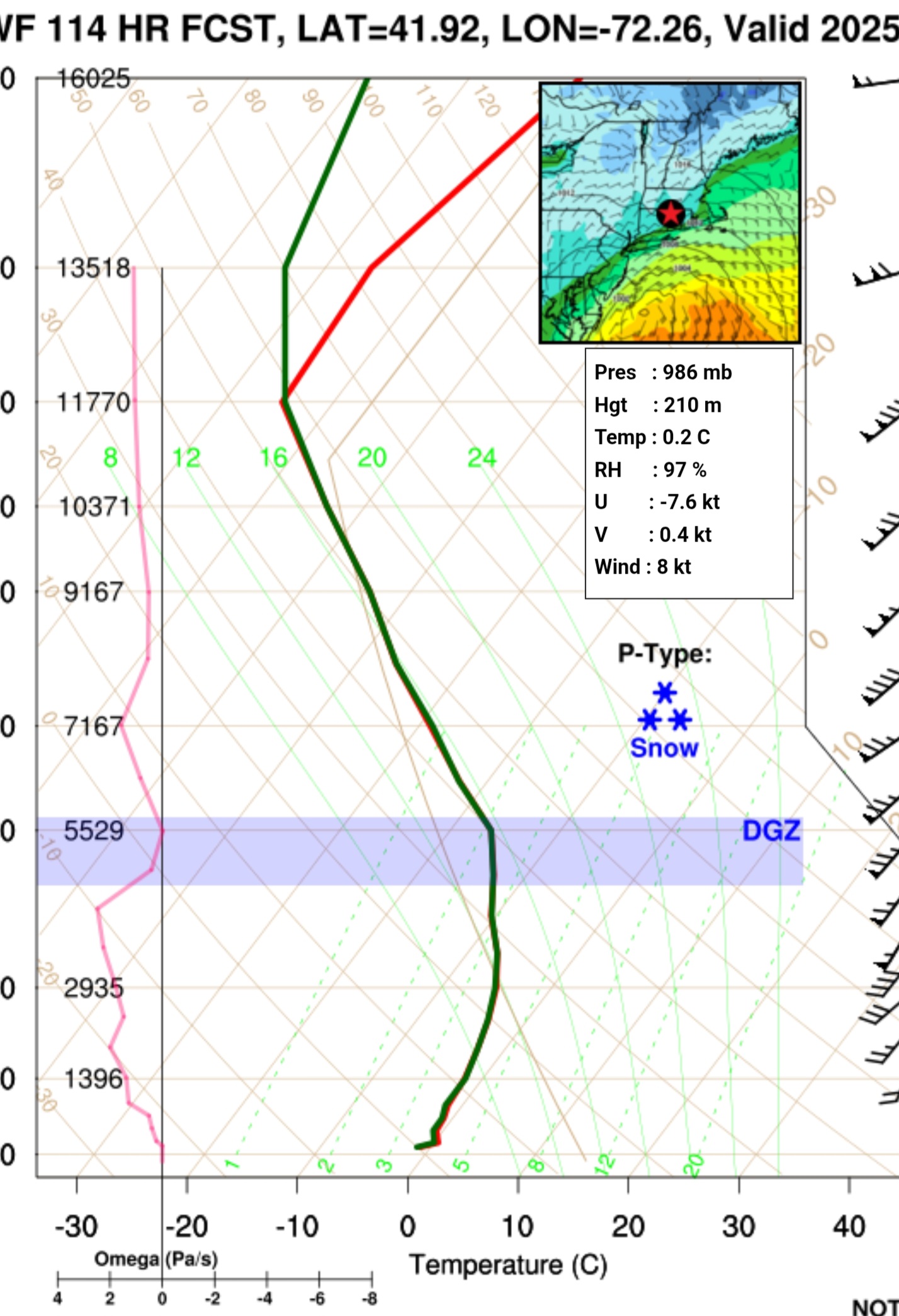
Let's go 6z Euro is a dumper. Isothermic . Humpy dumpy.thumb.jpg.db13b2265689954dbe00ecad89405334.jpg)

-
06Z GFS looks pretty slick out this way Tuesday morning. 0.75” FZRA. A lot of it with temps 29-30°
-
GFS vortmax is further north than we'd want based on "my lack of formal training" experience. Euro is further south, but still not completely ideal. That's been a trend for the last couple years...northern stream is either too far north or flatting the southern stream. At this point, I just want a storm that reminds me that we can in fact get a southern stream dominant wave that drops an inch of precip over the region.
-
December 2025 regional war/obs/disco thread
Ginx snewx replied to Torch Tiger's topic in New England
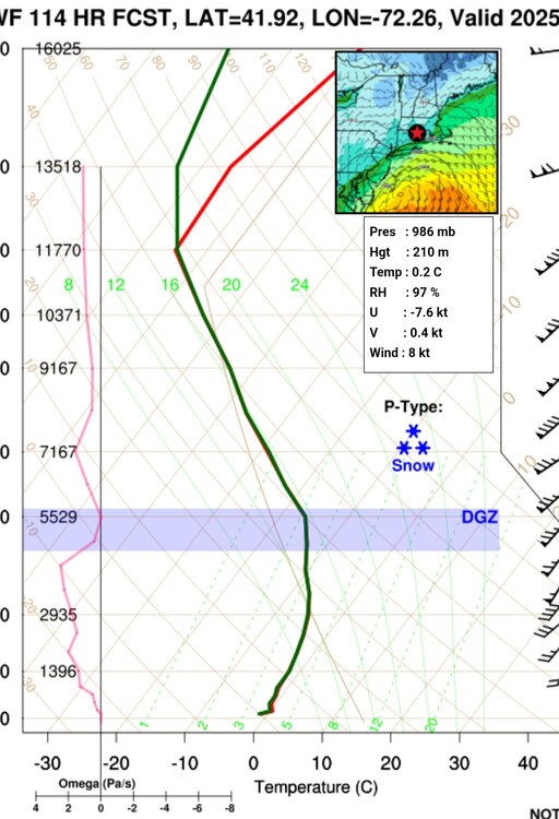
If one could only see soundings. Oh wait at least at my point and click 6Z Euro is isothermic below 0C with a very unstable convective airmass . Why would you toss the best model?.thumb.jpg.37ab84e6c52947c88ffcd5e04f18c104.jpg)
-

December 2025 regional war/obs/disco thread
Baroclinic Zone replied to Torch Tiger's topic in New England
Thread hath been giveth.


.jpg.86072047d6307b5aca461b45db1e667c.jpg)


.jpg.f965a6f09b655d7dea6f31ae7cf7dbff.jpg)