All Activity
- Past hour
-
But he was referring to DC not S PA.
-
Way more up here. Almost 6” lol
-

12/14: Sunday funday? Will the south win again?
BlizzardNole replied to TSSN+'s topic in Mid Atlantic
With afternoon temps well into the 40s you're probably looking at just wet roads on the drive home. Roads might be dicey after midnight though! -

12/14: Sunday funday? Will the south win again?
MN Transplant replied to TSSN+'s topic in Mid Atlantic
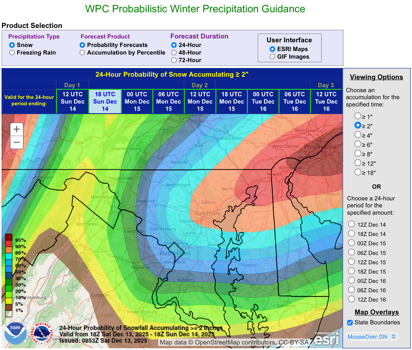
Ends up about identical to 6z around DC. 2" -

12/14: Sunday funday? Will the south win again?
MillvilleWx replied to TSSN+'s topic in Mid Atlantic
North-central NJ -

12/14: Sunday funday? Will the south win again?
Stormchaserchuck1 replied to TSSN+'s topic in Mid Atlantic
12z Hrr cutting back totals a little bit south of PA -
12/14: Sunday funday? Will the south win again?
MillvilleWx replied to TSSN+'s topic in Mid Atlantic
He ain’t wrong. I think 5-9” is in the cards for some from South Jersey back to NE MD. I’ll be at the shore for this one. I want to be able to drive around in it with my Dad and enjoy it, so I’m hoping for 1-2” that falls a light to moderate clip. Time to enjoy what falls! Good luck to all, and remember, all December snow is good snow -

December 14th - Snow showers or Plowable snow?
WinterWolf replied to Sey-Mour Snow's topic in New England
Be hilarious if the kid gets the call right…that’s funny. -

-
12z hrrr is just crushing northern crew thru hour 18. Already 3-4” in me, psu and Mitch area and band is going off.
-

Central PA Winter 25/26 Discussion and Obs
Mount Joy Snowman replied to MAG5035's topic in Upstate New York/Pennsylvania
Low of 22. I’m setting the Over/Under at 2” for KMJS tonight. I think I go a smidge over. Looking forward to seeing flakes fly tonight. Cheers to everyone! -

Minor snowfall sunday 12/14/25 1-4” possible
Yanksfan replied to WeatherGeek2025's topic in New York City Metro
Channel 7 (accu-weather) not buying the more amped trends as of yet. Still calling for 1-3 with 3+ at the shoreline. -
Oh I figured you didn't have anything on the ground, rooting for you today. Also rooting GO ARMY BEAT NAVY!
-
18 this morning
-
December 14th - Snow showers or Plowable snow?
WinterWolf replied to Sey-Mour Snow's topic in New England
Absolutely Pat…let’s get some. Funny thing, I have a wedding this afternoon evening, down in North Stonington, and normally that’s the snow to rain capitol of CT..but not this time…they’ll probably be the JP. -
Hoping this one holds or improves slightly. Has the feeling of a close call for many w guidance shifting ever so slightly ENE as we close. 2” IMBY would be nice. I don’t think that’s being too greedy

-

December 14th - Snow showers or Plowable snow?
CoastalWx replied to Sey-Mour Snow's topic in New England
My son just said the pike is good for 2-4”. I replied ok Kevin. lol. -

Minor snowfall sunday 12/14/25 1-4” possible
psv88 replied to WeatherGeek2025's topic in New York City Metro
New WWA for Suffolk for 3-5”. Nassau west still 2-4” -
-5F. I think it’ll be an indoors Saturday for us.
-

December 14th - Snow showers or Plowable snow?
Patrick-02540 replied to Sey-Mour Snow's topic in New England
My mindset is 2" would be solid for me/you. Anything more would be a great bonus. -
December 14th - Snow showers or Plowable snow?
WinterWolf replied to Sey-Mour Snow's topic in New England
Ya, Don…and you too. You’ve been steady on that, so credit to you too. -

12/14: Sunday funday? Will the south win again?
SomeguyfromTakomaPark replied to TSSN+'s topic in Mid Atlantic
It’s actually pretty cool to look at snowfall maps on this scale now that you’ve posted, it gives you a sense of how narrow these systems are on a global scale and therefore how hard it is for models to pin down small bands of heavy snow. -
December 14th - Snow showers or Plowable snow?
CoastalWx replied to Sey-Mour Snow's topic in New England
It’s always all about him. -
Nws reduced expected amt to less than 1” for mby and no WWA (eastern loudoun) but increased high-end potential to 4-5”. Low expectations but high upside.
-
No idea who this is but i like what they're saying