All Activity
- Past hour
-
got to be one of the worst parts of the job-making inclement weather calls...outside of the easy ones (like the blizzard) it's tough.
-
Middlesex County CT and the CT River Valley in Mass around Springfield local screw zones this winter..
-
Tort reform is desperately needed, but never comes
-
Yea we don’t mind the closures personally but other parents don’t have as much luxury/flexibility. I get it though, it is never as easy as just looking at the weather forecast for a decision…
-
rain sleet mix here 33
-
Ended up being the right call here, sidewalks already slick for pickup with the radar lit up to our west with snow and sleet.. The sleet makes it worse as it doesn't melt as quickly as the snow does with the March sun
-
nice map and appreciate all the effort you put into this! Just my 2 cents but I don't buy those 52"/53" totals in in south ORH county at all .. seems much too low
-
Light snow here - it's almost coming down in slow motion
-
Ripping massive flakes
-
And it’s colder here..29 with close to moderate snow now.
-
I think these are the biggest snowflakes I've ever seen!
-
yeah and that's what led to today-an overcorrection the wrong way. (except in Fairfield we have a normal full day which was the right call) to the dismay of my sons lol
-
I agree…whether we like that, or not.
-
That’s on them for f’ing up last Wednesday. Our guy here had a delay, and then went to canceling last Wednesday …he made the right call. You’re guy not so much.
-
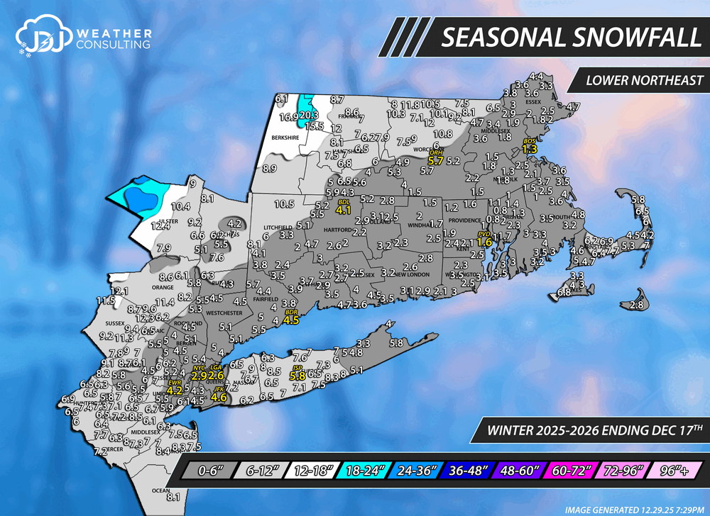
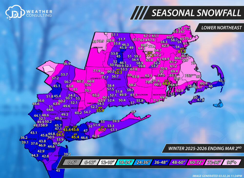
Season to date snowfall ending March 2nd. Reports are from here, cocorahs, COOP, climate sites. This was a tough one with a lot of missing days in cocorahs and reports that didn't line up or make sense. Did the best i could with the information i had. SNE/Tri-State/CT only maps are also up and a season progression animation. Winter 25-26 Seasonal Snowfall This is the 4th update of the season and probably the second to last update with a final map coming in April sometime when the threat of additional snow drops to near zero. March 2nd Update Snowfall Progression

-
Perfect at Saddleback with views to MWN
-
This whole event is quite warm frontal like. I was thinking it was more symbolic of that yesterday but now it looks like it is an actual WAA/overrunning venting out ahead of a diffused warm transition. Noooormally I'd go above machine guidance when looking at those synoptic params for tomorrow ... Not so sure over a foot of corn snow pack. It'll be an interesting ob. Either way, with unnoticeable light zephyrs but noticeably warmer March sun it's going to sensibly appeal pretty fantastic for spring enthusiasts circa 2:15 in the afternoon.
-
I for one am looking forward to my 16 years of cold.
-
It's a nanny state through and through. Gutless
-
Not so sure of that-the places that canceled along the shoreline are taking a beating for over-correcting the other way after last Wednesday's non call. it's 33 with light rain and wet roads and places are closed.
-
It would take a lot to have it happen but I wouldn't go as far to say a freak event. The blizzard of 1888 was a freak event.
-
Yeah, we’re not done after this.
-
I reached my ave 58 and 21 more. Let's hope we make a run at 100
-
No thank you.
-
Season to date snowfall ending March 2nd. Reports are from here, cocorahs, COOP, climate sites. This was a tough one with a lot of missing days in cocorahs and reports that didn't line up or make sense. Did the best i could with the information i had. SNE/Tri-State/CT only maps are also up and a season progression animation. Winter 25-26 Seasonal Snowfall This is the 4th update of the season and probably the second to last update with a final map coming in April sometime when the threat of additional snow drops to near zero. March 2nd Update Snowfall Progression