All Activity
- Past hour
-

Augdewst 2026: Summer's Last Stand
dendrite replied to Prismshine Productions's topic in New England
SLK is another site that didn’t have official early 90s obs pre-96 (ASOS era) so like MHT, I’m not sure what they’re doing statistically to derive the normals. -

Central PA Summer 2026 Discussion/Obs Thread
mahantango#1 replied to Voyager's topic in Upstate New York/Pennsylvania
Theres still some heat and humidity to be had before we close the book on summer. Fall is getting close, and for some of us...it's too close. -
Looks like some showers tomorrow afternoon now
-
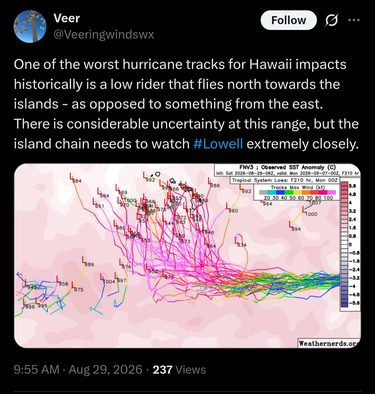
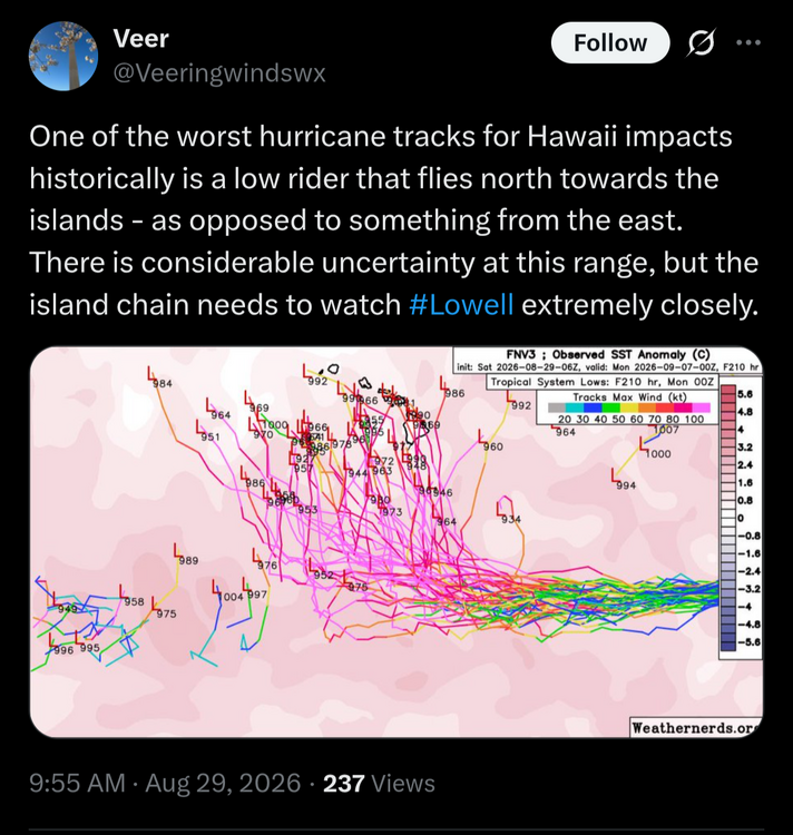
Looks like we finish August with .9 ACE points and a feeble 3.6 is the 2026 total to date. We'll see that September can deliver. Looks quiet for the next 5-7 days as least.
-
Top 10 day out there! 72 and clear. AC is off
-
Dollys remnants could get to the much more favorable Caribbean and so home gown Gulf energy on opportunities as well
-

Augdewst 2026: Summer's Last Stand
Brian5671 replied to Prismshine Productions's topic in New England
Top 10 day out there. AC is off. 72 under clear skies -
Records: Highs: EWR: 100 (1953) NYC: 98 (1973) LGA: 100 (1953) JFK: 98 (1953) Lows: EWR: 49 (1934) NYC: 50 (1965) LGA: 51 (1982) JFK: 51 (1982) Historical: 1559: Hurricane along Gulf Coast from Pensacola to Mobile. (Ref. AccWeather Weather History) 1816: Any remaining hopes of harvesting a corn crop were dashed by heavy frosts in northern New England. This was the second time this summer with heavy frosts. (Ref. Wilson Wx. History) 1863: A devastating killing frost affected most of Minnesota, killing vines and damaging corn. (Ref. AccWeather Weather History) 1876: A torrential downpour inundated St John's, Newfoundland Canada with 6.8 inches of rain, the greatest single daily accumulation ever recorded in the province. (Ref. Wilson Wx. History) 1893: A very destructive hurricane devastated the Georgia/South Carolina coast on the 27th. A tremendous wave submerged the offshore islands near Charleston and Savannah, killing between 1,000 and 2,500 people. The storm recurved to the northeast, passing through eastern Pennsylvania, still maintaining hurricane strength. Norfolk, VA, and New York City both measured a gust to 60 mph. To the west, Buffalo, NY received 4.22 inches of rain. (Ref. Wilson Wx. History) 1960 - The storm that would become Hurricane Donna forms near Cape Verde off the African coast. It would go on to cause 150 deaths from Puerto Rico to New England over the next two weeks. 1962 - Hackberry, LA, was deluged with twenty-two inches of rain in 24 hours, establishing a state record. (The Weather Channel) 1965 - A national record for the month of August was established when 2.5 inches of snow fell atop Mount Washington NH. Temperatures in New England dipped to 39 degrees at Nantucket MA, and to 25 degrees in Vermont. For many location it was the earliest freeze of record. (David Ludlum) 1978: The remnants of Tropical Storm Debra spawned a tornado in southern Memphis, TN. The twister was two miles long and 75-100 yards wide, left 26 injured and did $4.6 million damage. No thunder or lightning was observed. The tornado came within one mile of Elvis Presley's Graceland. (Ref. AccWeather Weather History) 1979: The strong winds of powerful Hurricane David leveled the island of Dominica in the Lesser Antilles, resulting in 56 deaths and leaving 60,000 of the islands 80,000 inhabitants homeless. (Ref. AccWeather Weather History) 1982: Canadian high pressure settled across the Mid-Atlantic brought record lows from the Great Lakes to the East Coast. The morning low of 39° at Pittsburgh, PA was their coldest reading ever in August. Cool air from Canada continues pouring in, Houghton Lake, MI: 29°, Ste. St. Marie, MI: 29°, Alpena, MI: 30°, Toledo, OH: 34°, Sterling (Dulles Airport), VA: 38°, Hartford, CT: 39°, Chicago, IL: 43°-Tied, Baltimore, MD: 49°, Richmond, VA: 50 °F. (Ref. Additional Temperatures Listed On This Link) 1983 - A devastating hail storm struck portions of central South Dakota. In a small part of Faulk County, hail pounded the area for two straight hours. At times, the hail was the size of baseballs. Of course, this incredible hailstorm devastated crops in the area and took out windows in area buildings. In one home, the windows were shattered, the curtains shredded, and glass shards and water ruined much of the upper floor. On some houses, the paint was peeled off by the continual pounding of the hail. Also, funnel clouds were reported just east of Lake City, and near Langford and Veblen in Marshall County. In Veblen, a pole barn was blown over, and shingles were torn off. 1984: The high temperature in Topeka, KS reached 110° for only the second time since the Dust Bowl days of the 1930's. The highest temperature on record at Columbia, MO for the month of August: 110° was recorded. (Ref. AccWeather Weather History) 1986: The minimum temperature was 49° in Washington DC that tied all-time August record minimum temperature. (Ref. Washington Weather Records - KDCA) Canadian high pressure across the Ohio Valley brought record chill from the Ohio Valley to the East Coast and Southeast. Record lows included: Concord, NH: 32°, Caribou, ME: 35°, Beckley, WV: 36°-Tied, Goshen, IN: 37°, Dayton, OH: 41°, Atlantic City, NJ: 41°-Tied, Asheville, NC: 42°, Roanoke, VA: 42°, Huntington, WV: 43°-Tied, Lynchburg, VA: 47°, Richmond, VA: 47°, Baltimore, MD: 47 °F. (Ref. Many Additional Temperatures Listed On This Link) 1987 - Some of the most powerful thunderstorms in several years developed over the piedmont of North Carolina, and marched across central sections of the state during the late afternoon and evening hours. Baseball size hail was reported around Albemarle, while thunderstorm winds downed giant trees around High Falls. (The National Weather Summary) (Storm Data) 1988 - Cool air invaded the north central U.S. Ten cities reported record low temperatures for the date, including Bismarck ND with a reading of 33 degrees. Deerfield, a small town in the Black Hills of South Dakota, reported a low of 23 degrees. The remnants of Tropical Storm Chris drenched eastern Pennsylvania with up to five and a half inches of rain, and produced high winds which gusted to 90 mph, severely damaging a hundred boats in Anne Arundel County MD. (The National Weather Summary) (Storm Data) 1989 - Evening thunderstorms produced destructive lightning in West Virginia. The lightning caused widepsread damage, particularily in Doddridge County. Numerous trees were downed closing many roads. Fire companies had a difficult time tending to the many homes and trailers on fire. Anchorage AK reported a record 9.60 inches of rain for the month of August. The average annual precipitation for Anchorage is just slighty more than fifteen inches. Three day rainfall totals in northwest Missouri ranged up to 8.20 inches at Maryville. (The National Weather Summary) 1991: Severe thunderstorms struck parts of southwest and central Oklahoma late in the evening. Rush Springs experienced winds stronger than 80 mph, and a bus barn and several mobile homes were destroyed in the area. The storms also produced golf ball sized hail northeast of Durham. In Kansas, thunderstorm wind gusts of 65 mph, combined with golf ball-size hail, blew out the windows of a few houses 3 miles west of Dodge City. At Garden City, lightning struck service transformers, electric lines, and buildings causing power outages and several structural fires. Lightning also caused one house fire that resulted in $20,000 damage. (Ref. Wilson Wx. History) 1995: The 1995 North Atlantic Hurricane Season was one of the busiest on record. The National Hurricane Center had their hands full on this date, as they tracked dissipating Tropical Storm Jerry, a strong tropical wave and four named storms: Hurricane Humberto, Hurricane Iris, Tropical Storm Karen and Tropical Storm Luis. (Ref. AccWeather Weather History) 1999: Parts of the Outer Banks of North Carolina were being evacuated as large Category 2 Hurricane Dennis continued to move towards the coast with top winds of 105 mph. The National Hurricane Center cautiously waited for the hurricane to make a much-anticipated turn to the east that would carry it out to sea and away from land. (Ref. Wilson Wx. History) 2000: The mercury reached 105° at Mobile, AL, setting an all-time record high. The record high also established a new mark for most 100 degree days in a summer with 8. Heavy rainfall totaling nearly 2.00 inches of rain soaked the northwest part of Las Vegas, NV. Several swift water rescues were performed after people ignored warning signs. (Ref. Wilson Wx. History) 2005 - Hurricane Katrina made landfall in Plaquemines Parish in southeastern Louisiana early on the 29th with maximum sustained winds near 125 mph, a strong category-three, and the third most-intense landfalling hurricane in U.S. history. The center of the hurricane passed just east of New Orleans, where winds gusted over 100 mph. Widespread devastation and unprecedented flooding occurred, submerging at least 80 percent of the city as levees failed. Farther east, powerful winds and a devastating storm surge of 20-30 feet raked the Mississippi coastline, including Gulfport and Biloxi, where Gulf of Mexico floodwaters spread several miles inland. Rainfall amounts of 8-10 inches were common along and to the east of the storm's path. Katrina weakened to a tropical storm as it tracked northward through Mississippi and gradually lost its identity as it moved into the Tennessee Valley on the 30th, dum 2017: Harvey was a Category 4 hurricane at its peak. It has since been downgraded to a tropical storm. But the hurricane scale is based on wind speed, not volume of water, and Harvey has continued to funnel tremendous amounts of moisture into Texas. The flood of epic proportions the southeast part of the city moved past 49 inches for the storm which breaks the Texas and Lower 48 states record for the most amount of rain ever recorded from a tropical system – pending verification. On Tuesday afternoon the 29th, the Mont Belvieu industrial suburb east of Houston recorded 51.12 inches of water, breaking the highest previous record of 48 inches from 1978’s Tropical Storm Amelia in Medina, Texas. “This is as catastrophic as you could possibly imagine from a Category 4 storm.” 2020: Just before dawn on Saturday morning the 29th, Laura became a post-tropical cyclone or remnant low as it was located approximately 90 miles to the west of Charleston, WV. Winds surrounding this remnant low were 25 mph. Laura had no impact on the Springfield Park Station or the Glen Allen area. In terms of wind speed, Laura tied the 1856 Last Island hurricane as the strongest landfalling hurricane on record in the state of Louisiana since 1851; however, the 1856 Last Island hurricane had a lowest minimum pressure of approximately 934 mb (27.58 in Hg). Significant storm surge was generated by the winds accompanying Hurricane Laura, which resulted in coastal flooding. Widespread torrential rains with amounts ranging from six to ten inches fell across western Louisiana and eastern Texas. With widespread damage caused by strong winds, a significant storm surge and rains, over half a million people were without power.
-
74 / 52 - gorgeous two days ahead today and sunday low - mid 80s. Ridge builds in but coincides with clouds and showers Mon - Thu then onshore tenedency still overall above normal 8/0 and beyond euro has a hotter labor day period - TBD. Ridge position key on osnhore / clouds / showees and lat season heat. Can Dolly's remnants get into the Caribbean and cause S-FL and EC issue in later period is option.
-
 https://zithindia.shop/# zithromax 250mg
 -
Augdewst 2026: Summer's Last Stand
Brian5671 replied to Prismshine Productions's topic in New England
I didn't think that was a cane -

Central PA Summer 2026 Discussion/Obs Thread
Blizzard of 93 replied to Voyager's topic in Upstate New York/Pennsylvania
55 for my Marysville low. Beautiful late Summer day is underway! -

Augdewst 2026: Summer's Last Stand
WxWatcher007 replied to Prismshine Productions's topic in New England
Huh, one thing I just noticed looking at SLK’s summer stats. June was +0.8°. July ended up dead normal. 0.0° departure. Can’t say I’ve seen that often for any site…but as of yesterday, August was also 0.0°. -
-
Central PA Summer 2026 Discussion/Obs Thread
mahantango#1 replied to Voyager's topic in Upstate New York/Pennsylvania
Pennsylvania Weather Watchers Bryant Sell · · Here is the 2026 Tornado list and map for Pennsylvania as of August 28th. 45 tornadoes this year is the 2nd most ever for any year! The only year with more is 1998 with 57. More statistics: 22 in June = 2nd most for June or any month 15 in July = 2nd most for July 8 in August = 2nd most for August 37 for June + July = Record most for June + July -
Really nice out! Refreshing! Overnight low here of 55. Got down to 45 in Walpack and 47 in Sandyston in NW Sussex County.
-
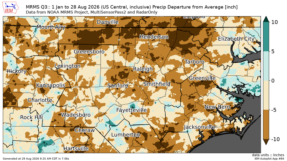
YTD anomolies
-
This is somehow way cooler than a full eclipse
-
Augdewst 2026: Summer's Last Stand
WxWatcher007 replied to Prismshine Productions's topic in New England
We love to see it. Seasonal change is beautiful. It was 35° like you mentioned at KSLK, but 46.3° here at WXW2. I am approximately 5 miles away from the airport as the crow flies. I’ve found that a 10 degree spread or so is normal on a rad cooling night. -

Augdewst 2026: Summer's Last Stand
Snowedin replied to Prismshine Productions's topic in New England
Fake cold -
0.26” of rain this morning which has more then doubled my August total to 0.46”
-
We got missed entirely the last two days.
- Today
-
Two tornados under those warnings near Saratoga
-

Augdewst 2026: Summer's Last Stand
Damage In Tolland replied to Prismshine Productions's topic in New England
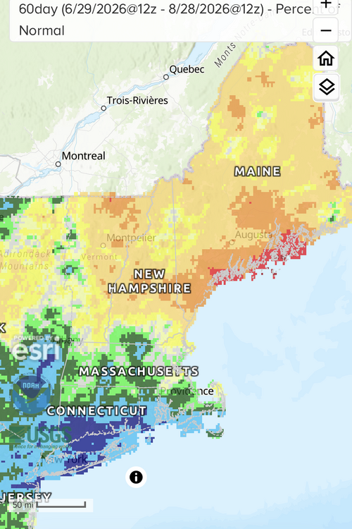
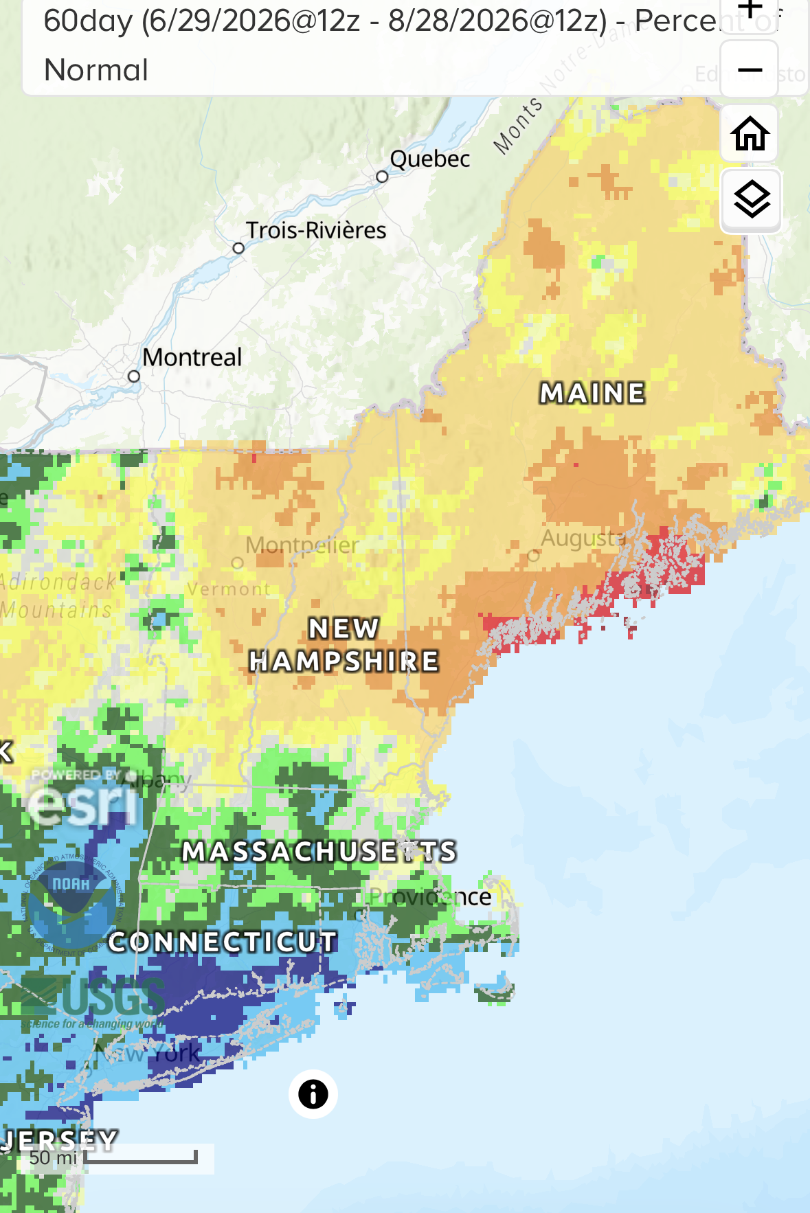
Just adding your months of qpf since May. It’s AN or at the very least normal -
Augdewst 2026: Summer's Last Stand
dendrite replied to Prismshine Productions's topic in New England
Yeah. Very wet here the last 60 days. Have another mimosa.