All Activity
- Past hour
-

Spooky Season (October Disco Thread)
jbenedet replied to Prismshine Productions's topic in New England
If it wasn’t obvious yet, those early hard frosts suck when we rebound to weekends like this for another 6 weeks. -
Totally making up from the March through June rains on weekends we had.
-
76 / 55 gorgeous day.
-

Spooky Season (October Disco Thread)
WxWatcher007 replied to Prismshine Productions's topic in New England
Beautiful day -
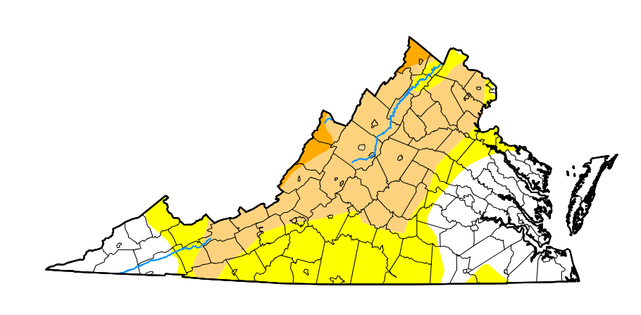
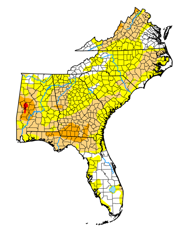
https://droughtmonitor.unl.edu/CurrentMap.aspx
-
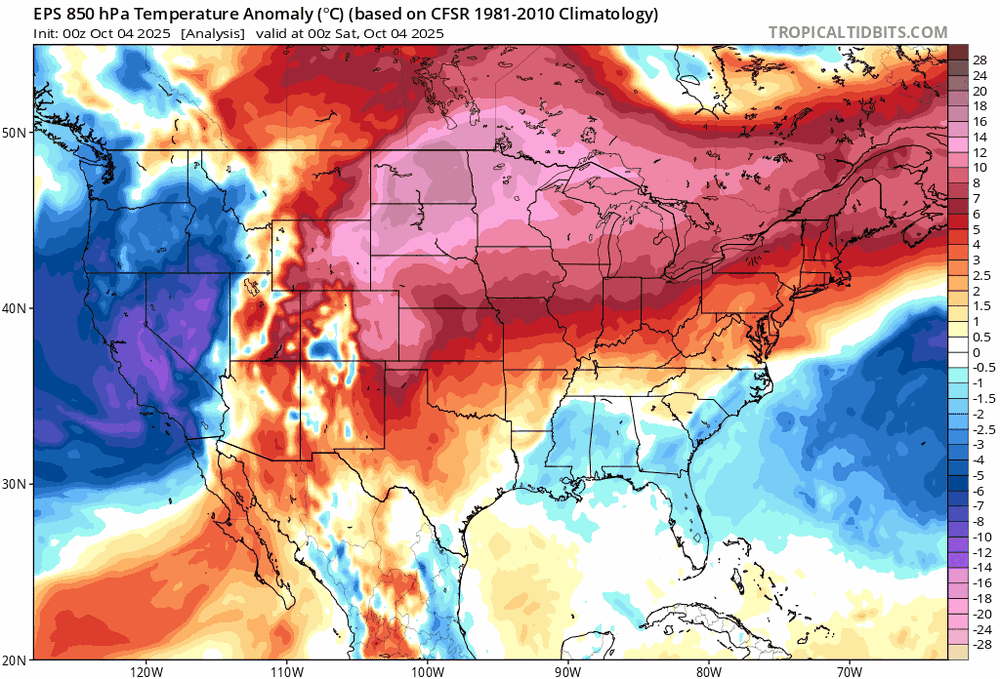
I usually support the idea of warmth overperforming but eps has been terrible at seeing cooldowns the last few months. I seriously doubt the midwest stays that warm for so long.
-
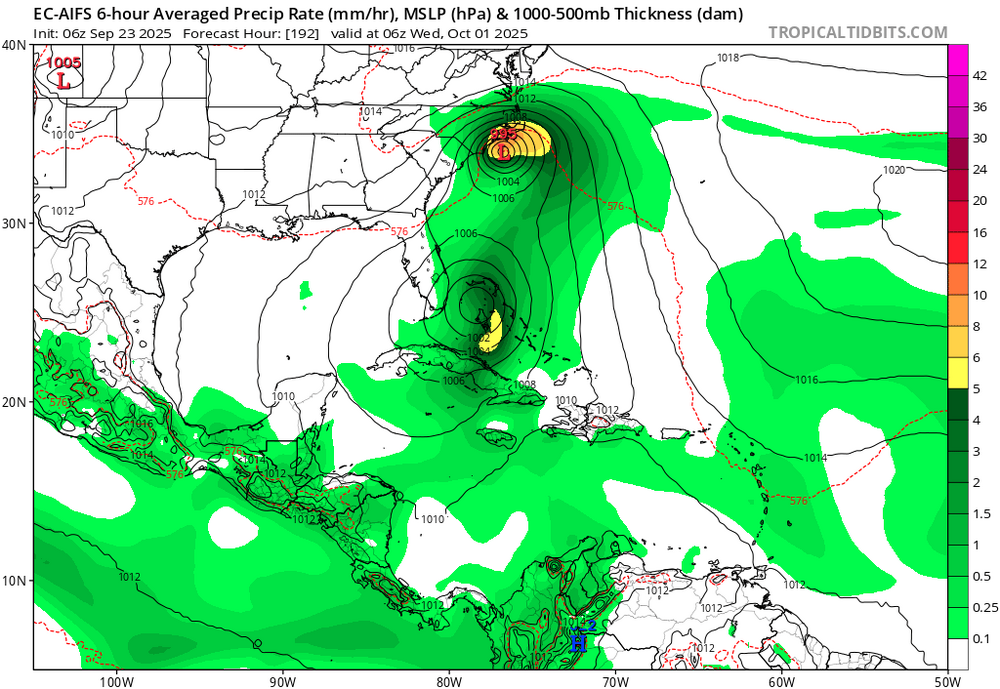
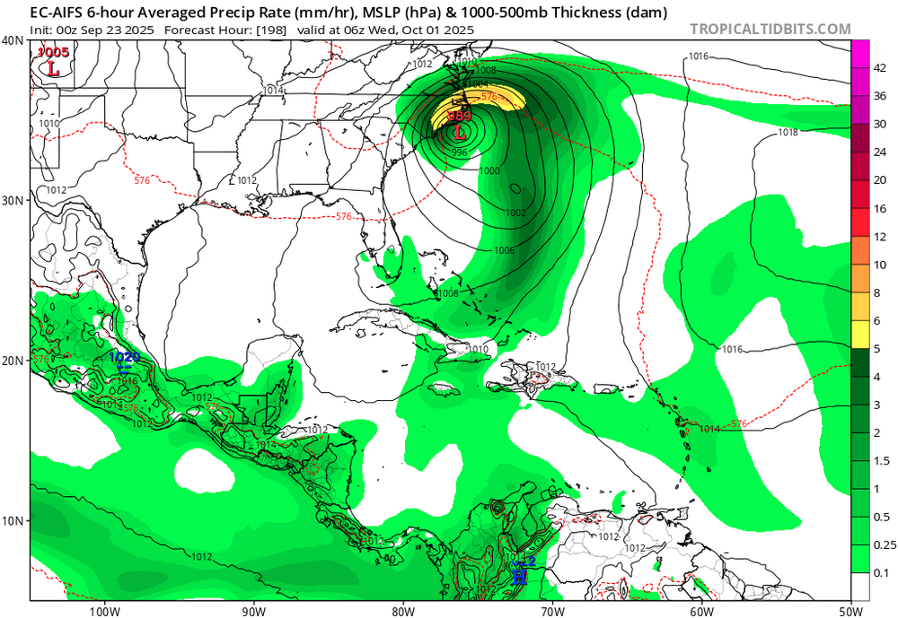
1. Humberto: the vast majority of all models never had it threaten the US 2. Imelda: -No UKMET or Icon had it hit the US and only one JMA did so. They were not only not schooled, they were the schoolers! -Several CMC had it hit as you implied. -A good # of GFS/Euro along with many ens members hit as you implied. -But some Euro AI runs hit, too, including from Humberto. So, UK, Icon, and JMA did better than Euro-AI: this top map has Humberto hit NC!

-
This is far more impressive than those August 91 degree "heat waves"
-
This 100%. Sustained temps above 85 are not normal outside of the core june-sept months and it's really bad to pretend they are.
-
why do this to yourself
-
And I also said cooler than previous runs, which it absolutely is
-
Before the snow comes in to Glacier NP, Montana
-
I said Euro, not EPS
-
k
- Today
-
This solar cycle is really taking its time to descend. September finished with sunspots at 135 for the month and the flux that started in August continues
-

2025-2026 ENSO
donsutherland1 replied to 40/70 Benchmark's topic in Weather Forecasting and Discussion
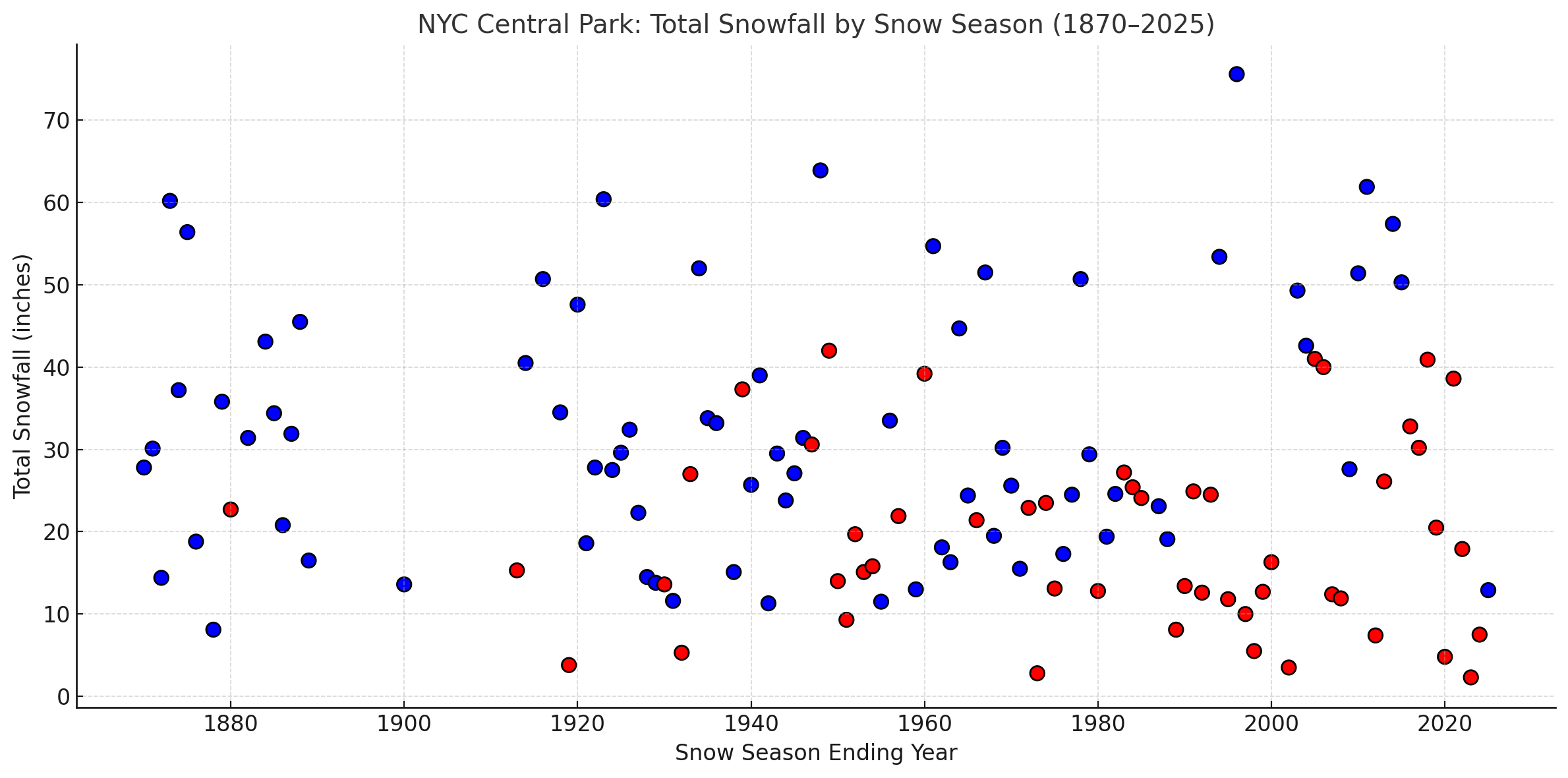
To illustrate @bluewavepoint about warming winters and reduced frequency of 50” snow seasons in NYC, here’s a chart that depicts winters with mean temperatures below 35 (blue) and 35 or above (red) and seasonal snowfall.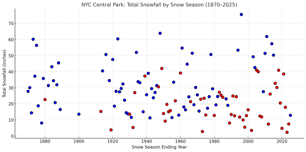
-
I’m in the SAV area. It’s pretty amazing how fast it has changed here. After ~17” of rain in August and water tables through the roof, I got only ~1” in Sept and see that the map you posted already has me in yellow.
-
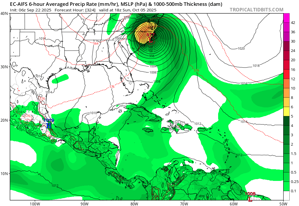
The new AI model runs want absolutely nothing at all to do with Atlantic tropical development the next couple of weeks. They actually did a very good job with the last 2 hurricanes, insisting that they were never going to even come close to making landfall in the SE. They actually schooled the operationals and ensembles of the other models. Are they onto something this time too? All we can do is wait and see at this point
-
Yeah looking at the long range into mid October, the models look fairly cool now. Of course we can't rule out the odd 80 degree day later in the fall, but today through Tuesday looks like our last truly summery period of the season. The drought will worsen as well with the dry pattern continuing.
-
The 0z EURO is much cooler for us that previous runs. Of course I am referring to the days past this Tuesday.
-
I know this sub-forum is mostly made up of North Carolina folk, but living in Tallahassee it's the closest I've got. We're currently under a severe drought after the 3rd driest September on record at TLH. Only ~0.5" of rain fell in September, which came at the end of the month on one day from one thunderstorm. There isn't any drenching rainfall expected in the next week or so, though scattered rainfall chances at least increase with a bit more southerly flow this weekend and early next week. Heading into our "dry" season, it could be an early start to the wildfire season as well. We might need a tropical system to really make a dent in the drought here across the Florida Panhandle, only at 10-20% of our normal rainfall in the past 30 days.
.thumb.png.8a97136344ec0b7deeb3e9a302ae6b3d.png)
-
Top 10 weekend coming up
-
I bottomed out at 53 degrees but I'm up almost 20 degrees already in the low 70s.
-
What a beautiful late spring day
-
Records: Highs: EWR: 89 (2013) NYC: 88 (1941) LGA: 86 (2013) JFK: 84 (1967) Lows: EWR: 33 (1945) NYC: 37 (1888) LGA: 38 (1945) JFK 39 (1996) Historical: 1679: New England from the 4th to the 5th: The Great Northeastern Rainstorm and Flood of October 1869 dumps 7.15 inches of rain in 24 hours on Middletown, Connecticut, most coming the morning of the 4th. Northeastern coastal Maine takes the full brunt of the hurricane as the storm surge produces tremendous tides. At the entrance to the Bay of Fundy, the islands of Deer, Grand Manan, and Campobello all sustain severe damage from wind and tide, as did the communities of Eastport and Calais, Maine . (Ref. WxDoctor) 1777 - The Battle of Germantown was fought in a morning fog that grew more dense with the smoke of battle, causing great confusion. Americans firing at each other contributed to the loss of the battle. (David Ludlum) 1867: Galveston, TX has a track record of severe hurricanes. Almost 30 years to the day after the famous Racer's Hurricane struck the island city; another major hurricane brought violent winds and inundation. All of the wharves in Galveston were reportedly destroyed. (Ref. Wilson Wx. History) 1869 - A great storm struck New England. The storm reportedly was predicted twelve months in advance by a British officer named Saxby. Heavy rains and high floods plagued all of New England, with strong winds and high tides over New Hampshire and Maine. Canton CT was deluged with 12.35 inches of rain. (David Ludlum) 1877: Washington, DC set a new 24-hour rainfall record for the month of October when 3.98" fell on the 4th. (Ref. Rainfall record as of the year 1877) 1957: The world's first artificial satellite, Sputnik, was launched on October 4th, 1857 by the Soviet Union. Sputnik was about the size of a beach ball and weighed 183.9 pounds. It took about 98 minutes to orbit Earth on an elliptical path. 1963: Hurricane Flora spent 11 days wreaking havoc along her path through the Caribbean. The storm brought 170 mph winds and an 11 foot storm surge to Haiti, killing 5,000 people, making it the island nation's most destructive hurricane. The slow moving storm brought 15 - 20 inches of rain in 72 hours to parts of Cuba. The floods and mudslides killed 1,300 people in that island nation. Castro refused the United States' offer of help. (Ref. Wilson Wx. History) 1969 - Denver, CO, received 9.6 inches of snow. October of that year proved to be the coldest and snowiest of record for Denver, with a total snowfall for the month of 31.2 inches. (Weather Channel) 1974: Killing frost on 3rd and 4th in suburbs National Airport had a low of 34°F on the 4th. (Washington Weather Records - KDCA) (Ref. Many Additional Temperatures Listed On This Link) 1986 - Excessive flooding was reported along the Mississippi River and all over the Midwest, from Ohio to the Milk River in Montana. In some places it was the worst flooding of record. (Sandra and TI Richard Sanders - 1987) 1987 - A storm brought record snows to the northeastern U.S. Snowfall totals ranged up to 21 inches at North Springfield VT. It was the earliest snow of record for some locations. The storm claimed 17 lives in central New York State, injured 332 persons, and in Vermont caused seventeen million dollars damage. The six inch snow at Albany NY was their earliest measurable snow in 117 years of records. (The National Weather Summary) (Storm Data) (The Weather Channel) 1987 - Southern California continued to "shake and bake". An earthquake was reported during the morning, the second in a matter of days, and during the afternoon temperatures soared well above 100 degrees. Highs of 100 degrees at San Francisco, and 108 degrees at Los Angeles and Santa Maria, were October records. San Luis Obispo was the hot spot in the nation with an afternoon high of 111 degrees. (The National Weather Summary). 1987: A storm brought record snows to the northeastern U.S. Snowfall totals ranged up to 21 inches at North Springfield, VT. It was the earliest snow of record for some locations. The storm claimed 17 lives in central New York State, injured 332 persons, and in Vermont caused seventeen million dollars damage. The six-inch snow at Albany, NY, was their earliest measurable snow in 117 years of records. 1988 - Temperatures dipped below freezing in the north central U.S. Five cities in North Dakota and Nebraska reported record low temperatures for the date, including Bismarck ND with a reading of 17 degrees above zero. Low pressure brought snow and sleet to parts of Upper Michigan. (The National Weather Summary) 1989 - Unseasonably cold weather continued in the north central U.S., with freezing temperatures reported across much of the area from eastern North Dakota to Michigan and northwest Ohio. Thirteen cities reported record low temperatures for the date, including Saint Cloud MN, which was the cold spot in the nation with a morning low of 19 degrees. (The National Weather Summary) 1995: Opal became a hurricane on October 2. Opal continued to strengthen, and a period of rapid strengthening late of the 3rd and early on the 4th made it a Category 4 hurricane. Opal weaken on the 4th, and Opal was a Category 3 hurricane when it made landfall near Pensacola Beach, Florida late on the 4th. Opal continued quickly north-northeastward and became extratropical over the Ohio Valley on the 5th. Hurlbert Field, Florida reported sustained winds of 84 mph with a peak gust of 144 mph, and gusts to 70 mph occurred as far inland as northwest Georgia. However, the main impact from Opal was from storm surge. A combination of storm surge and breaking waves inundated portions of the western Florida Panhandle coast to a depth of 10 to 20 ft. The surge was responsible for the bulk of the $3 billion in damage attributed to Opal in the United States. Opal was responsible for 9 deaths in the United States, including 8 from falling trees and one from a tornado. Opal was responsible for 50 deaths in Mexico and Guatemala due to flooding caused by heavy rains.(Ref. Additional Information At This Link) (Ref. AccWeather Weather History) 1998: Two rounds of thunderstorms at Kansas City, MO produced flash floods that killed 12 people. Most people died after driving their automobiles into rushing water. Over 100 water rescues were required during the event. 7 people died when their cars became stranded on a single bridge over Brush Creek. The National Weather Service received a commendation for their excellent warnings during the event. The first of numerous flash flood warnings had a lead time of over 30 minutes. Total damage exceeded $50 million dollars. (Ref. Wilson Wx. History) Oklahoma: 27 tornadoes touch down across Oklahoma establishing the national record for tornadoes in any state on a single October day. (Ref. WxDoctor) On the backside of this storm, an early season blizzard struck much of Converse and Niobrara Counties in Wyoming. 8 to 12 inches of heavy, wet snow fell from late on the 4th into the 5th over many areas. This combined with 40 mph winds snapped about 200 power poles and left about 4,000 people without power in Lusk and Manville for up to 5 days.(Ref. Wilson Wx. History) (Ref. AccWeather Weather History) 2005: Hurricane Stan made landfall along the Mexican coastline southeast of Veracruz. Torrential rains of 10 to 15 inches caused extensive flooding and loss of life across Central America. Death tolls reached 23 in Mexico, Nicaragua and Honduras, and 62 in El Salvador, but the greatest loss of life came in Guatemala, where as many as 2,000 people were killed in rain-related flooding and landslides. (Ref. Wilson Wx. History) Calendar day lows across much of the Midwest were 20 to 30 degrees warmer than normal. October 4th record-high minimum temperatures: 74 degrees (Lincoln, NE); 73 (Omaha, NE); 72 (Moline, IL); 71 (Rochester, MN and Waterloo, IA) ; 70 (Green Bay, WI). (Ref. Weather Guide Calendar with Phenomenal Weather Events 2011 Accord Pub. 2010, USA) 2006: Shoshone, Idaho: A rare October tornado touches down near Shoshone, Idaho community but causes no significant damage. NWS reports this is only the second recorded October tornado in the state. The previous occurred in October 1984 in Ada County.(Ref. WxDoctor) 2013: While western South Dakota was dealing with a crippling blizzard, the tri-state region of Nebraska, South Dakota, and Iowa saw several tornadoes, including an EF-4. This violent tornado started 2 miles southwest of Climbing Hill, Iowa, flattening corn crops and snapping tree trunks. As the tornado moved northeast, it intensified and struck a farmstead approximately 5 miles west-northwest of Correctionville, Iowa. Sheds and other buildings were severely damaged or destroyed, with the residence being severely damaged. The tornado continued to increase in both size and magnitude as it continued on its trek northeast. The tornado reached its maximum intensity 2.5 miles south of Pierson, Iowa, when this mile-wide tornado struck two farmsteads. Numerous outbuildings and barns were destroyed, with farm equipment being tossed over 400 yards. It was here that the tornado was rated EF-4. The tornado stayed southeast of Pierson, Iowa, and to the west of Washta, Iowa. Before lifting, the tornado produced more tree damage and downed power poles and lines 2 miles west of Washta, Iowa.


.png.11813b2b930a4b2f77967ff7ce56d9af.png)

