All Activity
- Past hour
-

2025-2026 ENSO
Daniel Boone replied to 40/70 Benchmark's topic in Weather Forecasting and Discussion
Yeah. As it stands now, the influence of the QBO on this Winter is a Mystery with the other Factors you mentioned and Other's in play. -
just give me a pattern that looks like it could work out, not these fantasy hook and ladder deals that never work out.
-
MRX is mentioning the potential for heavy rain tomorrow. The areas with the greatest chances for 2+" of rain are I81/75west onto the Plateau. Just a heads up.
-
12z Euro would be tropical storm winds on the Cape with that Sandy like hook..
-
12z euro holds serve. Sent from my SM-G998U using Tapatalk
-
Sell it all.
-
Wasted away again?
-
12z Euro looked OTS then a high builds in and ends up brushing the Cape.. still lots of time and going to get a bunch of different solutions
-
A 5 mile swath did and it wasn't overly excessive. Same here, but mostly from a wet July. June and Aug weren't very wet or anything.
-

Invest 94L—20% 2 day and 60% seven day odds of development
GaWx replied to WxWatcher007's topic in Tropical Headquarters
12Z Euro: After forming in the Bahamas, it recurves away from the SE US and the center just misses Bermuda to the NW as it did for 93L two days earlier in this run. Then it turns back NW before ultimately turning back NE missing the NE US and barely missing Newfoundland. -
Maybe he can help?
-
Nah…just trying whatever psychology I can to get some rain.
-
I thought you had quit?
-
Great. We wound up with .58" overnight .
-
So much beer lately
-

September 2025 OBS-Discussion centered NYC subforum
Stormlover74 replied to wdrag's topic in New York City Metro
Euro wetter again
-
Congrats!! Similar to my non-rain chances today.
-
 As complicated a tropical development setup as you’ll ever see. Multiple competing waves, ULL progression, SE trough, a cat 4 hurricane nearby… Good luck making a call and standing on it with this setup
 -
lol f off
- Today
-
You’d better look again . N CT had a wet summer
-
Actually, the summer in Connecticut for the northern half of the state was just near normal, where the southern half of the state has been well below normal precipitation wise. So that's not a good correlation to why we're getting early color. Maybe it's just because it's been a more on the dry side?
-
Invest 94L—20% 2 day and 60% seven day odds of development
GaWx replied to WxWatcher007's topic in Tropical Headquarters
94L 6Z Euro at 144 had a strengthening 998 TS moving NNW N of the Bahamas threatening the SE US. 6Z Icon at 120 was well E of Euro 6Z GFS had nothing from this, alone, although it appears to combine its vorticity with 93L and develop that well offshore —————- No UK run has had this as a TC AFAIK as of then. But 12Z UK: TD in NW Bahamas that drifts NE NEW TROPICAL CYCLONE FORECAST TO DEVELOP AFTER 138 HOURS FORECAST POSITION AT T+138 : 25.0N 77.1W LEAD CENTRAL MAXIMUM WIND VERIFYING TIME TIME POSITION PRESSURE (MB) SPEED (KNOTS) -------------- ---- -------- ------------- ------------- 1200UTC 29.09.2025 144 25.6N 76.9W 1010 30 0000UTC 30.09.2025 156 26.0N 76.2W 1009 24 1200UTC 30.09.2025 168 26.9N 74.2W 1008 27 -
Not a drop so far today.
-
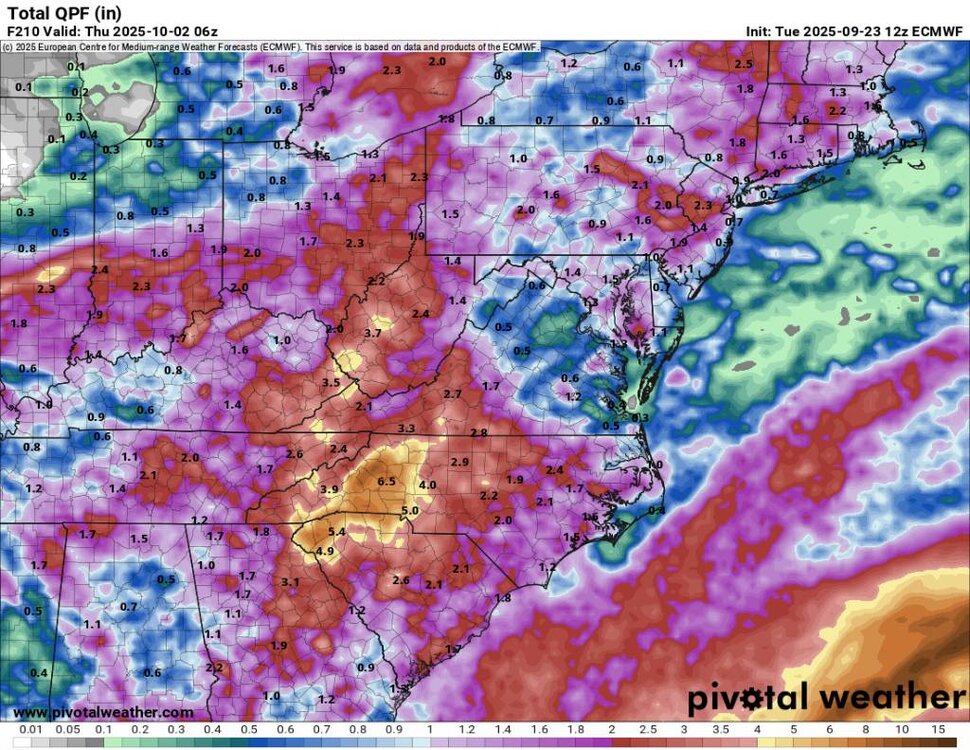
This looks like a CMC winter qpf output.
-
Modern conceptualization of "colder" is probably near normal.