All Activity
- Past hour
-

2026-2027 Super El Nino
40/70 Benchmark replied to Stormchaserchuck1's topic in Weather Forecasting and Discussion
I'm sure below average, but LES belts are a wild card. 1972-1973, 1982-1983, 1997-1998, 2015-2016. -
 Friend stopped by not an hour ago has a place in Big sky. He left for just that reason. Who knew SNE is the temperate part of the country?
 -

2026-2027 Super El Nino
BuffaloWeather replied to Stormchaserchuck1's topic in Weather Forecasting and Discussion
Whats the average snowfall for Super El Nino years look like in the northeast/Great lakes? The temps are insane here in Buffalo.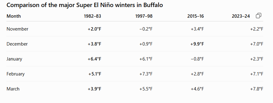
-
110’ of water loss over a basin that size is fucking insane.
-
Another top ten
-
 the heat will always find you
 -
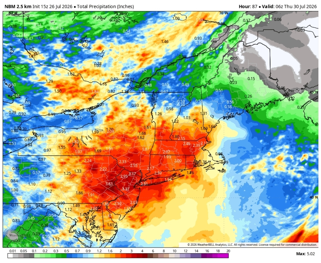
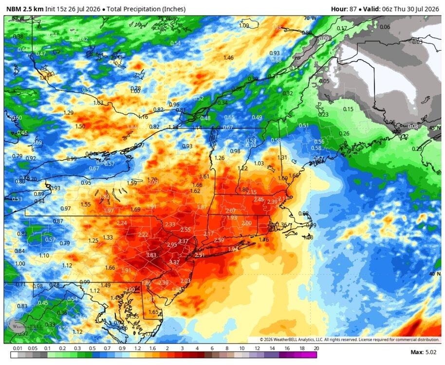
Gotta be extremely careful here just rip and reading total QPF maps. It might be difficult to get widespread amounts as modeled. The axis of highest totals is going to be confined to where the warm front is located and this will be a narrow axis. Also potential for this to close off to our west which would introduce dry slot concerns. Going to be a quite a bit of convection though so there are going to be some areas that probably get smoked, but we may see some drastic differences in precip. amounts across the region when all said and done. There should be some concern though for some significant flash flooding but how widespread?
-
2026-2027 Super El Nino
40/70 Benchmark replied to Stormchaserchuck1's topic in Weather Forecasting and Discussion
I could see a situation like 2005, 2015 and 2016 where we flip with a big storm the last week of January, but it would be a mild month in the mean. -
If you have a strong closed low with PWATs above 2" in late July then someone's gonna see a ton of rain. Given the rains we've had this month I see a flood risk upgrade to moderate for Tuesday
-
WPC's afternoon update below has increased totals again for the Mid Atlantic region. Here is a snippet from the AFD Mount Holly - PWats will rise to near 2" by the end of the day. Some models suggest we could have a stalled or slow moving frontal boundary across the central or northern portion of the forecast area, which could act as a focusing mechanism for heavy rainfall. Heavy rain leading to flash flooding could end up being a bigger concern and greater impact than the severe thunderstorm threat.
-

2026-2027 Super El Nino
PhiEaglesfan712 replied to Stormchaserchuck1's topic in Weather Forecasting and Discussion
I think it was January 2019: 2019-01-12 37 30 33.5 -3.8 31 0 0.13 1.9 0 2019-01-13 32 29 30.5 -6.7 34 0 0.71 8.3 4 2019-01-14 37 27 32.0 -5.2 33 0 T 0.1 10 -
Oh awesome seems like last time I believe but gotcha .
-
 Imagine moving to MT and thinking you're getting away from the heat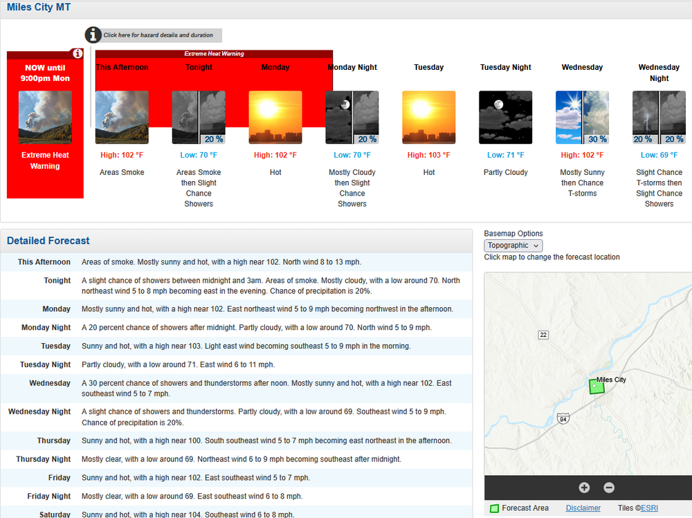
-
Gettin' there
.png.d02931190474f901a4e0b63b05f521b2.png)
-

Central PA Summer 2026 Discussion/Obs Thread
TheDreamTraveler replied to Voyager's topic in Upstate New York/Pennsylvania
Forecast high for today is 82 and it's already 84 degrees at 2 PM. Genuinely what is going on. This has been multiple days in a row now the temp forecast has been off by multiple degrees. If it's 84 now it'll probably get to 85 or 86 by 5 PM. -
2026-2027 Super El Nino
40/70 Benchmark replied to Stormchaserchuck1's topic in Weather Forecasting and Discussion
I'm not talking about early on...forget that. December is going to be warm. Case closed. But some guidance like the JMA and EURO are trying to pull it back far enough west to salvage January....that is what I am skeptical of. I think that guidance is overdone. -
I don't get the Freedom Models. Not sure they're included in the blend.
-
TKGW 49° in Durham in July is NBD.
-
 If you’d look at them for once you’d see the trend
 -
Which models are these?
-

2026-2027 Super El Nino
snowman19 replied to Stormchaserchuck1's topic in Weather Forecasting and Discussion
-
Yeah they are a good sign
-
2026-2027 Super El Nino
40/70 Benchmark replied to Stormchaserchuck1's topic in Weather Forecasting and Discussion
Exciting stuff....there is a unicorn scenario in there which it pulls everything just far enough to act like a Modoki, but I would only bet on that for small periods right now. - Today
-
Most seemingly is by a MCS into the night and early morning,the low level shear and lapse rates get better leading into later today,as to where this MCS goes which seems to be middle TN or east TN is still the question,Plenty of instability.HRR shows the KI-index of 44,would be quite a light show around Nashville,probably will back down later runs on that
-
2026-2027 Super El Nino
snowman19 replied to Stormchaserchuck1's topic in Weather Forecasting and Discussion
We aren’t going to know how the atmosphere is going to react (forcing) to having the 30C isotherm east of the dateline until this fall. Even 1997 never saw the 30C warm pool come this far east. The models continue to show it getting all the way to 140W, which is definitely believable now given all the record WWBs and there is also no precedent for it since that has never happened before