All Activity
- Past hour
-

Augdewst 2026: Summer's Last Stand
weatherwiz replied to Prismshine Productions's topic in New England
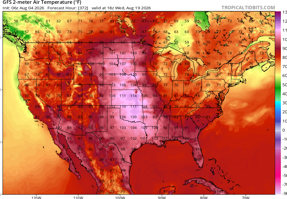
Almost looks like a similar transition to the pattern we had a few weeks back. That is some ridge being modeled second half of the month...that is a massive area of 600+ dm heights on the GFS. -

Augdewst 2026: Summer's Last Stand
Damage In Tolland replied to Prismshine Productions's topic in New England
The month as a whole ( as previously mentioned) will be AN and remembered for how humid it was . There is literally no back breaker cold front in sight in terms of extended cool and no dews. Super Nino late summer always turns into extended summer well into fall . -
lol
-

2026-2027 Super El Nino
PhiEaglesfan712 replied to Stormchaserchuck1's topic in Weather Forecasting and Discussion
MJJ 2026 ONI (NOAA): +1.4 MJJ 2026 RONI: +1.0 AMJ 2026 ONI (Eric Webb): +1.0 [NOAA's value came at +0.9] -

Augdewst 2026: Summer's Last Stand
CoastalWx replied to Prismshine Productions's topic in New England
Yeah dews extend into a portion of next week. After that it will cool down, but then perhaps warm up again later on in the 2nd half of the month. -
Augdewst 2026: Summer's Last Stand
weatherwiz replied to Prismshine Productions's topic in New England
Much of next week is going to be quite warm with high dewpoints, at least until the front moves through sometime second half of the week. We definitely encounter a period of around average temperatures with low humidity, should that western ridge become as stout as some guidance suggests and we end up with a NW flow. We'll see how long that holds though...may get one more run at big heat/humidity following that period. -

Augdewst 2026: Summer's Last Stand
ineedsnow replied to Prismshine Productions's topic in New England
This week always looked dewy and warm.. looks like next week we start the trend down. -
Wanted to share that I've changed jobs recently and this time I'm a fed contractor. Sadly, I won't have faster access to model maps before they're publicly accessible, so I'm back to being a pivotal/TT consumer just like many on here.
-

Augdewst 2026: Summer's Last Stand
jlauderdal replied to Prismshine Productions's topic in New England
Floriduh dewpoint alert for Friday. -
Alls clear on the waters so far
-
Records: Highs: EWR: 100 (1993) NYC: 100 (1944) LGA: 99 (1944) JFK: 93 (2006) Lows: EWR: 58 (1945) NYC: 55 (1874) LGA: 62 (1964) JFK: 57 (1964) Historical: 1609: Sir Thomas Gates, future governor of Virginia, was on his way to England from Jamestown. On Saint James Day, while between Cuba and the Bahamas, a "most terrible and vehement storm" raged for 44 hours. One of the small vessels in the fleet sank to the bottom of the Florida Straits. Four of the remaining vessels reached Virginia soon after the storm...followed a few days later by three other ships. The flagship, known as Sea Adventure, disappeared and was presumed lost. A small bit of fortune befell the ship and her crew when they made landfall on Bermuda. Although the vessel was damaged on a surrounding coral reef, all survived and spent ten months on the unsettled isle. The Spaniards, though shipwrecked on the island many times, had failed to colonize there. The British claimed the island and quickly settled the subtropical isle. In May 1610, they set forth for Jamestown, this time arriving at their destination. This near catastrophe provided the inspiration and background for William Shakespeare's play, The Tempest. (Ref. The Tempest) 1882 - A vivid aurora was visible from Oregon to Maine, down the east coast as far as Mayport FL, and inland as far as Wellington KS. Observers at Louisville KY noted merry dancers across the sky, and observers at Saint Vincent, MN, noted it was probably the most brilliant ever seen at that location. (The Weather Channel) 1915: Tropical storm from the North Bahamas moved over the Washington, DC area on a northeast track gave 2.34 inches of rain and winds to 46 mph from the SE. (Ref. Washington Weather Records ) 75 people died in flooding at Erie, PA. Many streets were flooded and bridges washed away. (Ref. AccWeather Weather History) 1930: The temperature at Moorefield, WV soared to 112 degrees to establish a state record, having reached 110 degrees the previous day. Widespread drought after April of that year caused some towns to haul water for domestic use, and many manufacturing plants were barely operational.(The Weather Channel) (Ref. Additional Temperatures Listed On This Link) 1930 - The temperature at Moorefield, WV, soared to 112 degrees to establish a state record, having reached 110 degrees the previous day. Widespread drought after April of that year caused some towns to haul water for domestic use, and many manufacturing plants were barely operational. (The Weather Channel) 1961 - Spokane, WA, reached an all-time record high of 108 degrees. Kalispell, MT, set an all-time record with a reading of 105 degrees. (The Weather Channel) 1980 - A record forty-two consecutive days of 100 degree heat finally came to an end at the Dallas-Fort Worth Airport. July 1980 proved to be the hottest month of record with a mean temperature of 92 degrees. There was just one day of rain in July, and there was no measurable rain in August. There were 18 more days of 100 degree heat in August, and four in September. Hot weather that summer contributed to the deaths of 1200 people nationally, and losses from the heat across the country were estimated at twenty billion dollars. (David Ludlum) (The Weather Channel) 1981: This was a day to remember in portions of south central South Dakota as an unusually long lived thunderstorm wind event hit the area. In St. Francis a radio station reported a gust of 86 mph, but that was only the beginning. For the next 20 minutes winds of 50 to 70 mph hammered the area doing massive damage to trees and a few trailers in the area. (Ref. Wilson Wx. History) 1982: The low temperature at Billings, MT was 60°. This began a string of 19 consecutive days on which the low temperature did not drop below 60°, the record longest such streak in August. (Ref. Wilson Wx. History) 1987 - A cold front brought relief from the heat to a large part of the Midwest, while hot weather continued in the south central and eastern U.S. Morning thunderstorms in Nebraska deluged the town of Dalton with 8.71 inches of rain, along with hail three inches in diameter, which accumulated up to four feet deep near the town of Dix. (Storm Data) (The National Weather Summary) 1988 - Thunderstorms produced severe weather from eastern Iowa to Lower Michigan during the afternoon and evening hours, producing golf ball size hail and spawning several tornadoes. A thunderstorm at Maquoketa, IA, produced wind gusts to 75 mph. (Storm Data) (The National Weather Summary) 1989 - Thunderstorms produced severe weather from eastern Nebraska and northeastern Kansas to the Great Lakes Region, with 150 reports of large hail or damaging winds during the afternoon, evening, and nighttime hours. Thunderstorms produced tennis ball size hail at Claremont, MN, and wind gusts to 75 mph at Milwaukee, WI. Thunderstorms representing what once was Hurricane Chantal produced five inches of rain at Grant, MI, and deluged Chicago, IL, with more than three inches of rain in three hours. (Storm Data) (The National Weather Summary) 1994: Boston, Massachusetts had 16 days from July 20 to August 4 giving the greatest number of days with temperatures of 70 degrees or above. (Ref. NOAA Boston Weather Events) 1995: Thunderstorms over northwest Iowa storms grew quickly, producing golf ball to baseball size hail over Palo Alto County near Ayrshire and Webb. As the storms moved south, a copious amount of hail was dropped. Just north of Rush Lake in Palo Alto County, pea-sized hail covered the ground to a depth of 12 inches. The storms then moved into northern Pocahontas County where they dropped softball size hail, which has a diameter of 4.50 inches, just north of Laurens. Golf ball size hail also continued to fall over Pocahontas County near the communities of Pocahontas and Havelock. The storms weakened a bit as they moved into Sac and Calhoun Counties. Crop damage totaled about $335,000 from these storms. Record heat prevailed across parts of the East. Record highs included: Philadelphia, PA: 98°, LaGuardia Airport (NYC), NY: 96°, Wilmington, DE: 96° and Bridgeport, CT: 93°. (Ref. Wilson Wx. History) 1998: College Station, Texas: The last of a string of 30 consecutive days with temperatures greater than 100 °F. 49 such days will be recorded in the blistering Summer of '98. (Ref. WxDoctor) Dallas, TX saw its streak of 29 consecutive days with temperatures 100° or hotter come to an end. It was the second longest streak of 100° plus days in the city's history. Record highs occurred across the southwest including Borrego Springs, CA: 116°, Redding, CA: 112°, Victorville, CA: 110°, Stockton, CA: 109°, Sacramento, CA: 108°, Riverside, CA: 106°, Escondido, CA: 99°, Idyllwild, CA: 96°, Palomar Mountain, CA: 95° and Big Bear Lake, CA: 88° and San Francisco (Airport), CA: 87°. (Ref. Wilson Wx. History) 2006: Washington DC: The temperature at Ronald Reagan National Airport reaches 101 °F the hottest ever for that day in the nation's capitol. (Ref. WxDoctor) 2008: Severe storms moved across northern Illinois and Indiana with tornadoes and stiff winds reported. With tornado sirens blaring, the game at Wrigley Field between Cubs and Astros was stopped as fans were told to evacuate to the lower concourse. Passengers at O’Hare International Airport were evacuated to lower levels of buildings as well. An estimated 350 flights were canceled. 2012: Third of the top ten weather events - Summer Heat Wave. June 22-August 4. Extreme heat that began over the High Plains, expanded to the Fast Coast, and then centered on the Heartland broke thousands of temperature records and resulted in July 2012 edging out July 1936 as the hottest month on record for the contiguous United States. The heat, which was blamed for over 100 deaths, contributed to the drought that affected much of the country. Top 2012 Weather Events (Ref.Weatherwise May/June 2013 volumn 66 /number3 page 17) 2020: Tropical Storm Isaias hit the eastern third of Virginia hardest on Tuesday morning during its brief but destructive journey up the Eastern Seaboard. Several hours of torrential rain flooded dozens of roads, while winds gusting past 45 mph downed trees and put hundreds of thousands of homes and businesses in the dark. The storm left scattered road closures and power outages in metro Richmond and more widespread disruption across the Tidewater region, where winds approached 70 mph. No serious damage was reported in the western half of the state. (Ref. The Richmond Times Dispatch)(Ref. The Richmond Times Dispatch)
-
76 sunny - dewpoints in the low-mid 60s. Nice day on tap low - mid 80s some stray areas to 87/88. The mainly northerly flow comes around southerly later today humidity pump back up, more storms tomorrow and Southern Florida style in/out clouds warm/steamy and some drenchers. Thu - Mon warm-hot / humid scattered storm chances a opportunity for 90s (low). Overall warm / humid through the 11th. Cold front moves through 8/12 with moderation back to normal with heat capped south of us looks to moderate warmer towards mid month and beyond again.
-
Yeah same here...reseeded, looking good now!
-

Augdewst 2026: Summer's Last Stand
Brewbeer replied to Prismshine Productions's topic in New England
heading to VT next week for camping with the kids, weather looking good ! -
Thanks for posting about this perspective about borealization, which presents it as a net negative. Modeling the potential myriad of effects of continued GW for the globe as a whole remains a highly complex and thus difficult endeavor. Thus having good discussions on these topics is beneficial.
-
My lawn was decimated after those 2 dry summers-we re-seeded last fall....looks incredible today lol with all the rain
-

Augdewst 2026: Summer's Last Stand
Prismshine Productions replied to Prismshine Productions's topic in New England
Yeah the 6z GFS showed this at the end of the run, highs in the 60s/70s and lows in the mid-lower 50s Sent from my SM-S176V using Tapatalk -
The expansion of the boreal forests into the tundra raises another set of issues. https://www.technologynetworks.com/applied-sciences/news/boreal-trees-are-spreading-into-the-arctic-tundra-405025 In an increasingly warmer world, the Arctic tundra is becoming more forestlike. This process, known as borealization, is particularly widespread in Eurasia and in Arctic mountain regions, where the distance to the boreal (northern) forest is shorter. Many species of grasses and shrubs that can live in both the tundra and the forest are gaining ground in the tundra. This is shown by a new large-scale study of 1,100 sampling sites across the entire Arctic biome. Consequences “If this trend continues, it could have a number of consequences. For example, it could accelerate the melting of the permafrost or change the seasonal migration of reindeer. It could also affect the traditional livelihoods of the indigenous peoples of the Arctic, who rely on hunting, reindeer herding, and gathering plants as a part of their subsistence and cultural practice,” says Robert Björk, a researcher on Arctic ecosystems at the University of Gothenburg. When shrubs and other tree-like species expand, they trap more snow in winter and cover the ground in summer. This changes the ground temperature and can accelerate the thawing of the permafrost. As a result, large amounts of carbon that have been frozen for thousands of years could be released, contributing to global warming.
-

2026-2027 Super El Nino
snowman19 replied to Stormchaserchuck1's topic in Weather Forecasting and Discussion
A small area of +10C is starting to develop in the subsurface - Today
-
2.04" here yesterday with high temp of 87°.
-

2026-2027 Super El Nino
bluewave replied to Stormchaserchuck1's topic in Weather Forecasting and Discussion
Yeah, that is what I noticed especially reading the all-time record high pressure in Australia with the -SOI and extreme conditions in South America. Perhaps it’s related in some way to the record early stratospheric disruption last November. Following the strong blocking last winter, record low pressure developed north of Alaska during the spring and has continued into the summer. This has been associated with the record ridging and heat across the mid-latitudes. It would be a nice topic for a research paper. -
I’m referring to the increase in boreal forests and the overall increased green areas of the globe as being a positive spect of CC, not the increased fires themselves.
-
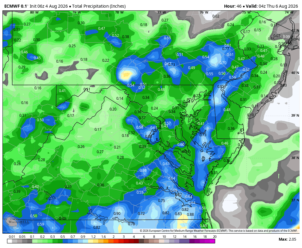
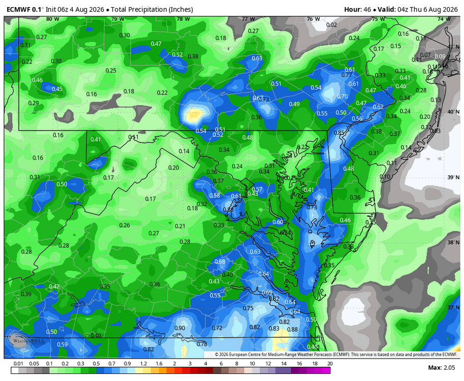
WB 6Z EURO thru Wed.
-
For me this was the most impressive drought I've seen. Two years with deficits of around 15" so a 30" deficit in total since 9/24. Much better lately of course .
-

2026-2027 Super El Nino
Terpeast replied to Stormchaserchuck1's topic in Weather Forecasting and Discussion
Southern hemisphere appears to be better synced with the el nino, though. Not perfectly, but close. Troughs and ridges look to be approximately in the same places, albeit slightly off. S Pac looks like split flow, aiding those record snows in the Chilean Andes.