All Activity
- Past hour
-
people felt a 2.9?!
-

Central PA Summer 2026 Discussion/Obs Thread
Jns2183 replied to Voyager's topic in Upstate New York/Pennsylvania
Heavy heavy rain in camp hill. These little cells are hyper efficient rain producers. I have a feeling the main issue today is going to be some bad flooding. The whole atmosphere is primed that way. Any storm damage is going to come from wet microbursts, but any wind is bad with weakend trees, now a wet upper soil. Uprooted trees are going to happen with any semi significant wind. Hopefully the bigger wind issues stay south today. I'll gladly take my chances with 5" of rain vs even a 40mph gust today Sent from my SM-S731U using Tapatalk -
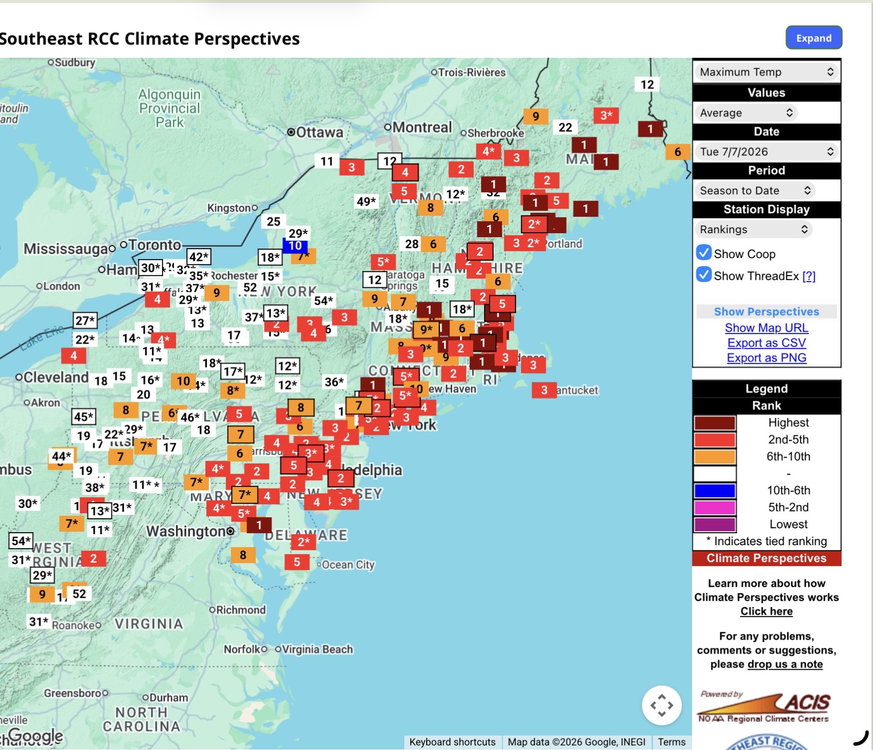
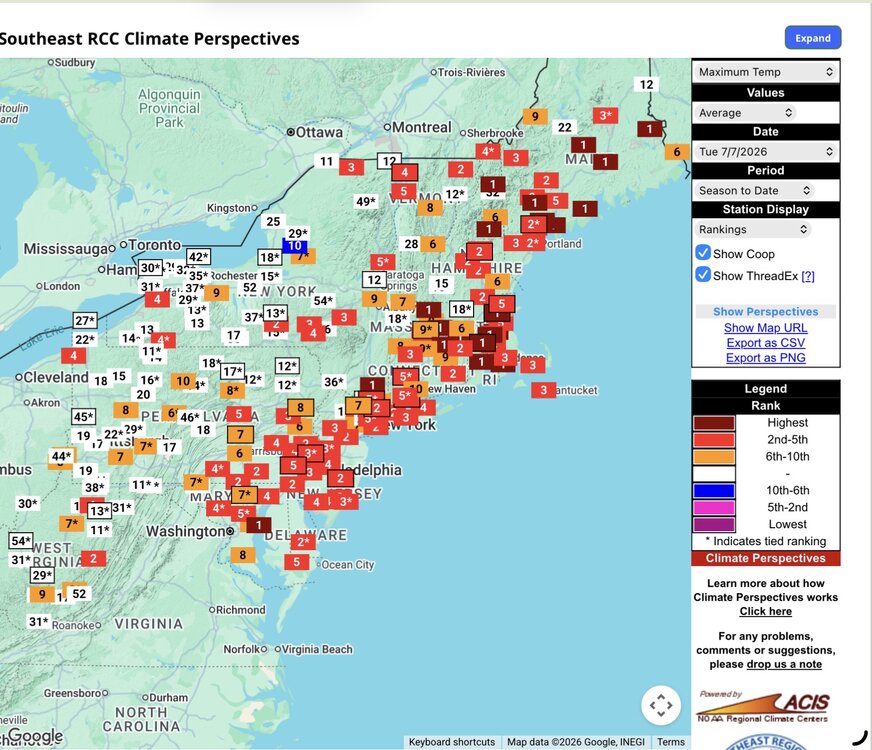
First time that Harrison,NJ away from the sea breeze reached 20 days of 90° or greater by July 8th. The station is in 3rd place for 95° days at 8. They are in 1st place with 4 days reaching 100°. The New Brunswick COOP is 2nd only to 2010 for the warmest average summer high temperature through June 8th. This matches the entire region which has numerous top 5 for average maximum temperature so far. Time Series Summary for HARRISON, NJ Most 90° days by July 8th Click column heading to sort ascending, click again to sort descending. 1 2026-07-08 20 0 - 2010-07-08 20 17 2 2018-07-08 18 0 3 2024-07-08 17 0 - 2021-07-08 17 0 - 2002-07-08 17 5 Time Series Summary for HARRISON, NJ Most 95° days by July 8th Click column heading to sort ascending, click again to sort descending. 1 2012-07-08 11 19 2 2021-07-08 9 0 3 2026-07-08 8 0 - 2010-07-08 8 17 Time Series Summary for HARRISON, NJ Click column heading to sort ascending, click again to sort descending. 1 2026-07-08 4 0 2 2025-07-08 3 0 - 2010-07-08 3 17 3 2021-07-08 2 0 - 2012-07-08 2 19 - 1999-07-08 2 1 Time Series Summary for NEW BRUNSWICK 3 SE, NJ Highest average maximum temperature June 1 to July 8 Click column heading to sort ascending, click again to sort descending. 1 2010-07-08 87.2 0 2 2026-07-08 86.3 0 3 2024-07-08 86.1 0 4 1999-07-08 84.8 0 5 2008-07-08 84.7 0
-
East wins
-

Central PA Summer 2026 Discussion/Obs Thread
pawatch replied to Voyager's topic in Upstate New York/Pennsylvania
69 for the low. DP 67 Looks like people in the southern tier might see some serious storms today. -
You should! Virginia Tech does have a small assemblance of a meaonet, but you have a much bigger state, so they could always use the public's support. You can DM and/or @wxmeddler for some ideas or talking points if you wish.
-
5 consecutive days where I’ve had measurable precipitation, and my yearly negative departure has grown.
-
Oh look! A flood watch! What an exciting forecast. 2-3" of rain, severe storms. I had that forecast for 4 days last week and got .12 lol. Hopefully this one actually happens. Probably just another flood for Glen Burnie and Fredrick
- Today
-
feast or famine has been the way of the land for what feels like years now but yeah, glad we soaked it up while the getting was good
-
 That's odd given the much warmer and more humid climate. People do adapt over time and it's all what one is used to. I noticed it when I first moved to DC. The first couple of summers, it was a bit tough getting used to the persistent HHH wx in the summer (temps avg 6 deg higher in DCA than BOS), but by the 3rd summer, I had adapted. And it works the other way. This past winter was the coldest by far since I moved here, and it was noticeable that temps that I had no issues w/ in BOS were! We all have the same body temp. Yes, some ppl take the heat better, just like some take the cold better, but for the majority, it is about same. There is a reason why 68 F is considered room temp, as a reference standard. If the avg temp is in the low 90s and the DPs in the 70s in the summer, and that mets their criteria, that would mean a continuous state of alert/warning/advisory, and thus they lose their entire meaning! And since humans can live and thrive in areas of the globe that have heat indices 130+ most of the summer (e.g. Middle East), what, is the biology of humans in the U.S. somehow different that elsewhere on the globe?
 -

2026-2027 Super El Nino
snowman19 replied to Stormchaserchuck1's topic in Weather Forecasting and Discussion
This +QBO is actually helping to magnify and strengthen this super El Niño. It’s supporting a more robust MJO which enhances the WWBs/westerlies, DWKWs and warming; both surface and subsurface. It’s also helping to support strong ocean-atmosphere coupling (Bjerknes feedback). Once the +IOD gets going, it’s going to constructively interfere with this process even further. A record-breaking historic event is all but guaranteed at this point: “+QBO is not the engine of this chain; it is the stratospheric background modulator that determines under what conditions tropical convection can become more organized and persistent. A favorable vertical phase structure can support the deep convection of the MJO and upper tropospheric divergence by altering the temperature and stability field around the tropopause. The strengthening of the convective core over the Western–Central Equatorial Pacific, in turn, reorganizes the surface pressure gradient, increasing the likelihood of westerly wind anomalies and the development of Westerly Wind Bursts. Sufficiently strong and persistent WWBs transfer eastward momentum to the ocean; downwelling Kelvin waves, which induce downward displacement in the thermocline, transport the warm water volume to the central and eastern Pacific. This deepens the thermocline, paves the way for surface warming, and—if the existing ocean heat content is adequate—can strengthen ENSO coupling through the Bjerknes feedback. However, this process is neither linear nor inevitable; the ultimate response depends far more on the position and amplitude of the MJO, the duration of the WWB, the initial SST pattern, the state of the trade winds, and the preconditioning of the ocean than on the +QBO phase. The schema therefore represents not a definitive cause–effect chain, but a multiscale and state-dependent framework of tropical interactions extending from the stratosphere to the ocean.” ^ https://x.com/atmoslabwx/status/2074977555782996458?s=46&t=NChJQK9_PUjA1K7D2SMojw -
 He back quick
 -
2026-2027 Super El Nino
snowman19 replied to Stormchaserchuck1's topic in Weather Forecasting and Discussion
“The 2026-27 El Niño is simply astonishing. Tropical Pacific waters are running nearly 7 weeks ahead of where they’ve ever been at this point in an El Niño cycle in modern history. Models now put the peak strength at 3.6°C on the Relative Oceanic Niño Index (RONI), the new standard for measuring El Niño that adjusts for background ocean warming from climate change.” -
 Timing may be off for storms tomorrow. Hopefully not.
 -
 Saw on the news that they have different criteria even though it will be just as hot as some places in mass. I guess we just miss the criteria
 -

Central PA Summer 2026 Discussion/Obs Thread
mahantango#1 replied to Voyager's topic in Upstate New York/Pennsylvania
Flood Watch National Weather Service State College PA 210 AM EDT Thu Jul 9 2026 PAZ056-057-059-063>066-091915- /O.NEW.KCTP.FA.A.0006.260709T1600Z-260710T0400Z/ /00000.0.ER.000000T0000Z.000000T0000Z.000000T0000Z.OO/ Perry-Dauphin-Lebanon-Cumberland-Adams-York-Lancaster- Including the cities of Carlisle, Newport, Lancaster, Gettysburg, York, Lebanon, Harrisburg, and Hershey 210 AM EDT Thu Jul 9 2026 ...FLOOD WATCH IN EFFECT FROM NOON EDT TODAY THROUGH THIS EVENING... * WHAT...Flash flooding caused by excessive rainfall is possible. * WHERE...A portion of central Pennsylvania, including the following counties, Adams, Cumberland, Dauphin, Lancaster, Lebanon, Perry and York. * WHEN...From noon EDT today through this evening. * IMPACTS...Excessive runoff may result in flooding of rivers, creeks, streams, and other low-lying and flood-prone locations. Creeks and streams may rise out of their banks. Flooding may occur in poor drainage and urban areas. * ADDITIONAL DETAILS... - Multiple rounds of slow moving thunderstorms will be capable of producing torrential downpours, with rain rates potentially exceeding 2 inches per hour. While there is still some uncertainty regarding where the heaviest rainfall will occur, scattered instances of flash flooding will be possible. - http://www.weather.gov/safety/flood PRECAUTIONARY/PREPAREDNESS ACTIONS... You should monitor later forecasts and be prepared to take action should Flash Flood Warnings be issued. && $$ Bauco/Lambrech Hazardous Weather Outlook National Weather Service State College PA 408 AM EDT Thu Jul 9 2026 PAZ057-059-065-066-100815- Dauphin-Lebanon-York-Lancaster- 408 AM EDT Thu Jul 9 2026 ...FLOOD WATCH IN EFFECT FROM NOON EDT TODAY THROUGH THIS EVENING... This Hazardous Weather Outlook is for central Pennsylvania. .DAY ONE...Today and tonight. Please listen to NOAA Weather Radio or go to weather.gov/StateCollege on the internet for more information about the following hazards. Flood Watch. Showers and thunderstorms will produce very heavy rainfall that may lead to flash flooding. A few storms may produce strong to severe wind gusts. .DAYS TWO THROUGH SEVEN...Friday through Wednesday. Showers and thunderstorms may produce heavy rainfall on Friday. Isolated instances of flash flooding will be possible. .SPOTTER INFORMATION STATEMENT... Spotters are encouraged to report significant hazardous weather. -
Central PA Summer 2026 Discussion/Obs Thread
Jns2183 replied to Voyager's topic in Upstate New York/Pennsylvania
I'm jealous of the sleeping weather over by Kansas city. Some areas there have had 4 to 6 hours straight of rolling thunder and moderate rain with that MCS slowly crawling. I'd take that so fast. Window open another to hear it all. I think it was summer 2011, that we had that week straight of overnight MCS as we sat on edge of heat dome. It was horrible during the day living in swampland, but every night for a week straight around 2-3am I awoke to thunder, lightning, rain from a slowly dying MCS. If I remember correctly the plants were turbo charged all summer from the plentiful moisture and heat. I feel like some of you still have records from cutting grass that summer. Sent from my SM-S731U using Tapatalk -
Central PA Summer 2026 Discussion/Obs Thread
Jns2183 replied to Voyager's topic in Upstate New York/Pennsylvania
I think I can find the radar. I texted my friend, but he's on his way to Brazil currently so we shall see. How are farmers summer crops coming along? Sent from my SM-S731U using Tapatalk -
CoastalWx mentioning national news reminded me of something. This is probably when I came to realize what wx had become in terms of treating the ordinary as extraordinary and the lack of scaling/quantification. In late July 2014 I was visiting a friend at a TV station in NJ, and the ABC Word News Tonight at 630 came on. And the lead story? "We begin tonight w/ svr wx w/ at least one tornado touching down..." This is what happened on this day. https://www.spc.noaa.gov/climo/reports/140724_rpts.html The tornado in question was in Edgewater FL. It was an EF0 and damaged some hangars and planes at the local airport. No one was hurt. This is national news? This is *local* story only. It was a minor event, par for the course any day in July for svr wx. You have 30 min to talk about news of the world, and this is material for such a newscast? Are you telling me that this is the best the staff of a national newscast can do for a story? It is lazy journalism and wx is low-hanging fruit. Don't get me wrong, wx on a national newscast is entirely relevant, but confine to something significant overall that has widespread impact or causes injuries/fatalities.
-
Central PA Summer 2026 Discussion/Obs Thread
Jns2183 replied to Voyager's topic in Upstate New York/Pennsylvania
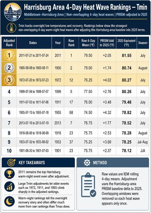
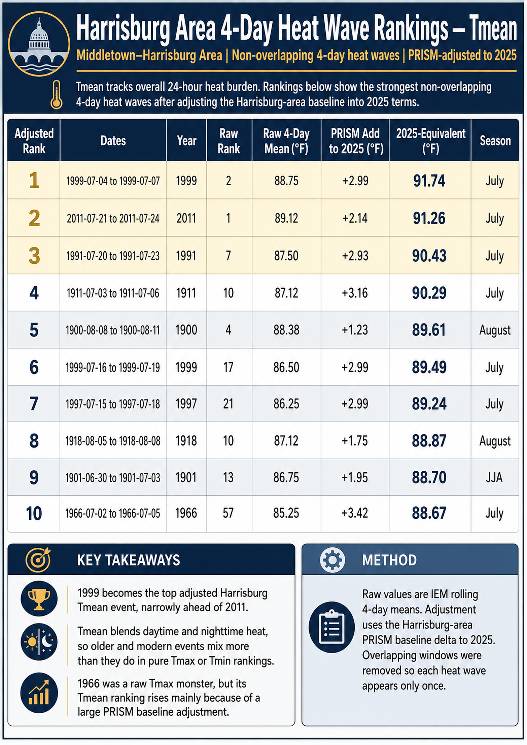
Here are my updated heatwave rankings. It doesn't have the latest one in them simply because I need to wait till July passes to properly weight the temperature. I don't think most people know just how dry the summer of 1966 was, nor that our hotest summer by max temperature was 1949. The 1930's to 1940's were brutal here. Hot summers and crappy snow in the winter. Sent from my SM-S731U using Tapatalk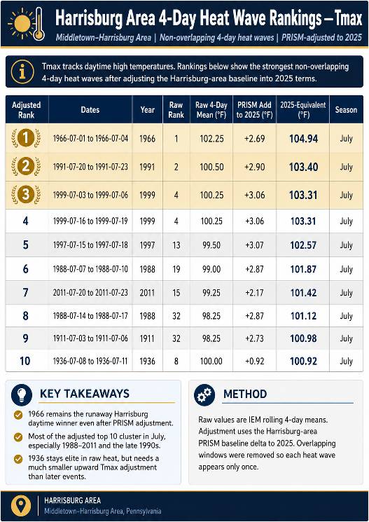
-
Just the topics of logical fallacies and cognitive biases *alone* is so much material. And we can all relate to them well b/c we are all susceptible and/or committed them at one time or another, and have experienced it first hand among the population and media.
-
Attractive headlines I have no issue w/ on a fundamental level, and they do have plenty of value, but as w/ anything, it can be abused, and that abuse line was crossed a long time ago IMHO. You wrote: "It is always best to ignore the hype in weather and sports... " I agree 100%, but it's very hard to b/c it is everywhere! Yes on social media platforms you can block words/phrases and ppl/sites, but it doesn't catch everything. Just casually watching TV or listening to radio, or ads on on sites like YouTube, it gets you. And over time, the drama, hype, and negative has worked their way into everything. You can't even have escapism watching a movie or show anymore w/o some kind of messaging or virtue signaling randomly inserted that has zero to do w/ the plot, but put in anyways.
-
It does not surprise me one bit! Never underestimate the drive to get more ratings, no matter how ridiculous or stupid it sounds! And it can be taken even further here, and it proves what I have said so many times in recent years. The ordinary is now turned into extraordinary! So this is a fcst for New Orleans. You know what the normal high temp is for June 27 (date of this article)? 91! And dew points are in the 70s almost all the time in summer, so afternoon heat indices are in the low 100s, and 107 like mentioned here happens a significant part of the time every summer. So how is this "dangerous?" This is normal climate for this area, and ppl are *used* to it. This idea that just b/c temps 90+ and the heat index 100+ somehow that means this summarily bad for humans is bunk. Ppl adapt well to their local climate no problem, have so for 1000s of years. "By Monday, temperatures will surge even higher as a strong heat bubble aloft moves northward over the Tennessee and Ohio River Valleys, keeping the New Orleans area well above normal. Combined with higher humidity, Tuesday is shaping up to be a hot day." 2 F higher is a "surge?" And 3 deg above avg for a high temps is not "well above normal." Oh, the drama! I get sometimes, "well, that's just the way it is." I am not contesting that. Society changes/evolves. What I am contesting is the relentless fear-mongering and making mountains out of molehills. Crying wolf all the time is a bad thing, no? Putting ppl in a constant state of alert is unhealthy both physically and psychologically.
-
The tactic "scare w/ large numbers" is a biggie. How about "340 million people under high UV risk today!" Sounds ridiculous, but the trend to demonize *everything* no matter what is strong, so just you wait! And one could say, "well, UV is ionizing radiation and is a real risk!" and they would not be wrong. Very sleazy way to justify hype. Since ubiquitous well-known risk exists every day routinely, there is no practical value bringing it up most of the time other than for ratings and hype. We learn about normal risk from a young age. Risk is everywhere, and constantly bringing attention to it is counterproductive. Yes, alert the population as needed, and *not* for your own profit/business!
-
Yet so many ppl do not think twice taking the dog out for a walk when lightning is hitting not that far away and the thunder is very loud. As long as it is not raining, who cares?