All Activity
- Past hour
-
Approximately lol. I think it has more to do with getting the measurement reasonably high enough so that heat from near the surface has less influence. My station is probably 4 1/2 feet. Having it in shade is a bigger deal. A radiation shield and proper ventilation can minimize errors when in direct sun.
-

2026-2027 Super El Nino
GaWx replied to Stormchaserchuck1's topic in Weather Forecasting and Discussion
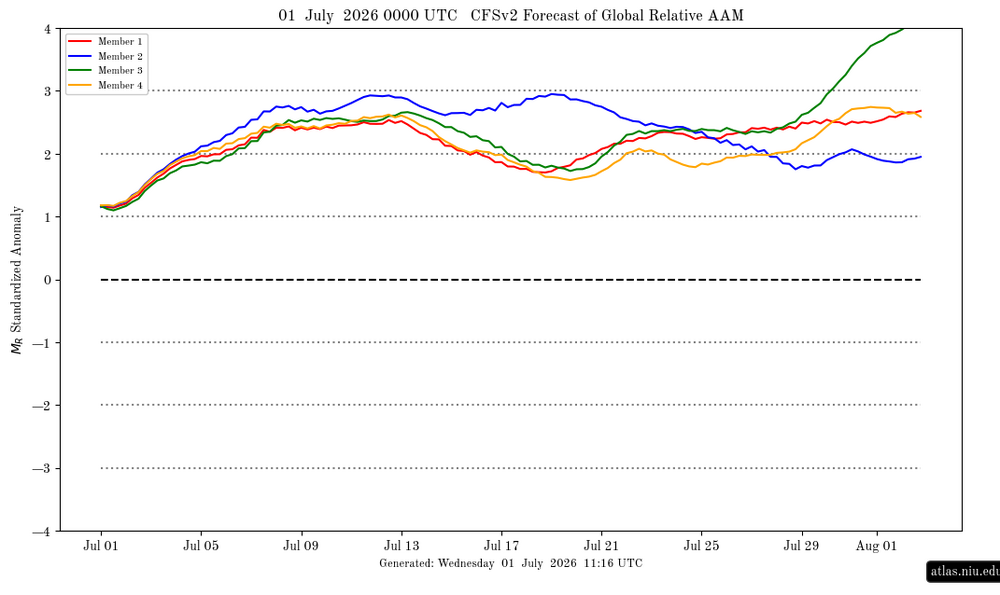
The CFS AAM forecast at the site I follow just updated for the first time in 6 days: Prior run there is 0Z of 6/25: way up at a mean of +2.8 to +3.3 July 8th to end of run, which is July 29th: Brand new run (0Z of 7/1): still a strong +AAM but not to the near record breaking levels of the 0Z 6/25 run as it’s ~+2.5 on July 8th instead of +2.8, it has a near term peak of ~+2.65 on July 12th-13th, and then it’s mainly low to mid +2s July 14-29th instead of +2.8 to +3.3: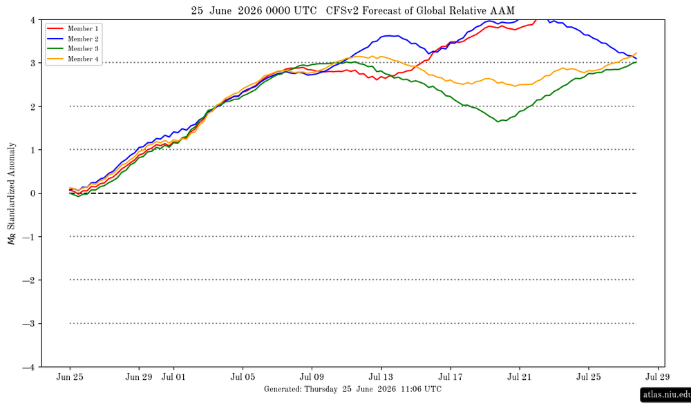
-

2026-2027 Super El Nino
40/70 Benchmark replied to Stormchaserchuck1's topic in Weather Forecasting and Discussion
I tried to clarify this yesterday...but all I mean when I call it "basin-wide" is just that-the intense anomalies are not relegated to only the east. Yes, they are strongest in the east, but given the magnitude it doesn't really matter. This is why the most intense El Nino events are all warm...because it spills into the eastern zones. Well, same situation here....we aren't getting a cold season because there is so much warmth in the eastern zones, but there is enough in the central and western flank to introduce some variability. I am not trying to imply that this is an excuse to forecast a 2002-2003 redux in the seasonal mean because there is too much warmth too far east-but what I am favoring is warm overall season with some episodes of MC and Modoki forcing mixed in. Thus this is what I am trying to convey with any mentions of the 2002 and 2009 analogs, not redux of those particular seasons. This is why why we have analog COMPOSITES. -
 Yeah..that'll be a fun test tonight and more likely tomorrow night. Do the climo-favored warm nocturnal therm sites hold 80+ ? It seems to me that's a tough one. It happens from time to time, but it seems more usual to end up with a 5 minute, 78.4 or 79.4 blip on an otherwise 80 80 80 ... 80 score card.
 -
 It's going to be an interesting afternoon I think in terms of convective development. Have to watch this area here. Not a ton going on right now but the NAM seems to blossom from this.
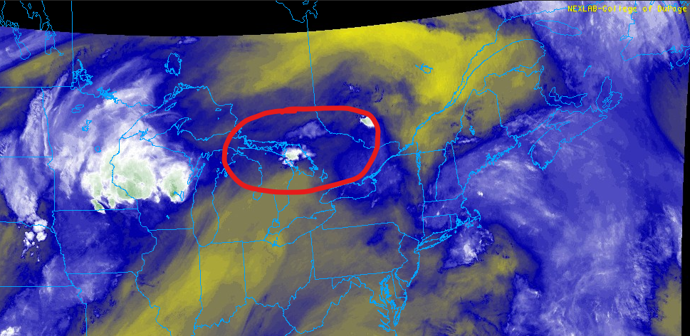
-
 RRFS, MSSL, ARW
 -
Hi res is higher
-
Heat kicks into high gear today and peaks tomorrow and Friday. June rainfall here was 5.51". Got lucky with a rather localized heavier total. Y.T.D. = 23.82. Some places far below these number across the metro area.
-

2026-2027 Super El Nino
mitchnick replied to Stormchaserchuck1's topic in Weather Forecasting and Discussion
I'm inland at 600', but the hills to my N & NE would be the better spot. Of course, if that was to happen, I'd say it would then be a shutout for most until January. -
Euro is super wet Monday
-
 Which model?
 -
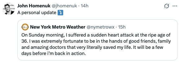
Came across this kind of by accident just now. This is "Earthlight" who used to be a regular and great poster on this forum. Wishing him well. Way too young for this. Jeez.
-
MOS/NBM are 76/77. But I'll say they get to 78
-
2026-2027 Super El Nino
40/70 Benchmark replied to Stormchaserchuck1's topic in Weather Forecasting and Discussion
Yea, I agree. Probably higher and deeper into the interior than my locale. -
no ... I think you're gonna find that no amount of distaste for heat, hot patterns, or those that like to rhetorically emphasize the significance of it... will change the reality that these are not very interfering, typical nocturnally enhance cloud types that are in the process ( like normal ...) of melting away with the diurnal processing of the sun - already evidence on high res sat. Heights are rising. That's intrinsically a DVM exertion. This will be a suppressive cloud factor as the day goes forward. Probably there will be mainly sunny conditions from 11 ... 11:30 on if not sooner. Should expect full realization of at least machine numbers. Probably a mean of 94 with outliers higher. Given the thrust of ridge bulging for the next 36 or so hours .. this will neg interfere with MCS mechanisms. I believe that MCS is not as much of a risk going forward until the other side, when we see the evolution of this ridge receding over the weekend. Perhaps Friday night?
-
6-foot-8 is head level? That is some tall people!
-
 January 1996 is The King™. There is no comparison.
 -
Guidance shows 80-81
-
2026-2027 Super El Nino
mitchnick replied to Stormchaserchuck1's topic in Weather Forecasting and Discussion
Warm early with better chances after the New Year is pretty much what current seasonal modeling (that goes through at least March) is showing. That said, as was posted earlier, with October Niños usually BN, I wouldn't be surprised if someone in the east, preferably higher elevations, get a fluke October or early November snowfall. Just a hunch. -
Close to an inch of rain here in several rounds-loud storms
-

Central PA Summer 2026 Discussion/Obs Thread
Jns2183 replied to Voyager's topic in Upstate New York/Pennsylvania
Any green grass left goes poof by monday Sent from my SM-S731U using Tapatalk -
Picked up around an inch
-
BDL will probably get down to 77-78
-
I know this post is 9 hours old ... and what I'm about to wonder is incredibly tedious but, I always think of BOS as being climate tainted in these west wind dragon tongue patterns. Logan AP, being basically right outside the Boston urban anus, isn't likely to be cooler than BAF. Probably it would be more like OWD... But like ..who cares. right
-

E PA/NJ/DE Summer 2026 Obs/Discussion
Hurricane Agnes replied to PhiEaglesfan712's topic in Philadelphia Region
Welcome! I was born and raised in Mt. Airy but what I remember about '77 was the glacial winter, with sheets of ice formed after endless melting and refreezing. The winter of '78-'79 (my senior year in high school) broke a long time snow drought, and after the biggest storm, my sisters and I built a good-sized snowman on the front lawn, and we ended up getting "tourists" stopping or slowing to take pics. Currently sunny and 80 with dp a juicy 73.


