All Activity
- Past hour
-
I don’t think we’re going to see anywhere near the amount of poleward ridging that we did last winter
-
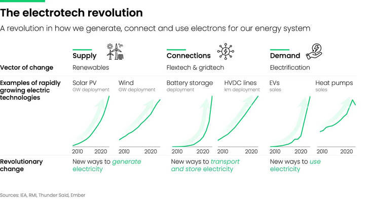
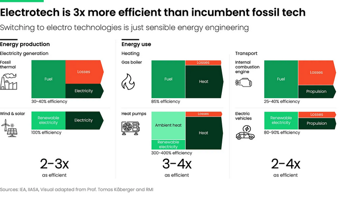
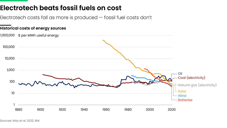
Trump's speech showed how unprepared the US is becoming for the future. https://electrotechrevolution.substack.com/p/rewiring-the-energy-debate?utm_source=substack&utm_campaign=post_embed&utm_medium=web


- Today
-
Thursday would have been much better than this nonstorm tonight. While in theory rain sounded like a good idea tonight, in reality when you get light rain like this at night it really sucks. It just makes the air more uncomfortable and much more humid and I've been up all night with a stuffy nose and sneezing. I'm about to turn on my air conditioning. A dry cool night with temperatures in the 50s is FAR superior to this. I hope the next time it rains it's when we get a noreaster. Either that or a strong frontal passage with cool dry weather behind it. Not this nonsense of a nonstorm. This is nothing but a godawful humidity pump.
-

September 2025 OBS-Discussion centered NYC subforum
LibertyBell replied to wdrag's topic in New York City Metro
This is probably why I'm so uncomfortable tonight, this socalled storm is nothing more than a humidity pump that triggered my allergies. -
September 2025 OBS-Discussion centered NYC subforum
LibertyBell replied to wdrag's topic in New York City Metro
I thought we weren't going to use 1891 because of its very limited dataset? The limited data at EWR in 1891 makes September look erroneously warm and makes October look erroneously cool lol. -

Spooky Season (October Disco Thread)
ineedsnow replied to Prismshine Productions's topic in New England
Let me know how your extended summer beach trip is.. -
September 2025 OBS-Discussion centered NYC subforum
LibertyBell replied to wdrag's topic in New York City Metro
I don't think it's going to be that extreme. Temperatures in the 70s are fine. There is no hot air around to make it that hot. -
September 2025 OBS-Discussion centered NYC subforum
LibertyBell replied to wdrag's topic in New York City Metro
While in theory rain sounded like a good idea, in reality when you get light rain like this at night it really sucks. It just makes the air more uncomfortable and much more humid and I've been up all night with a stuffy nose and sneezing. I'm about to turn on my air conditioning. A dry cool night with temperatures in the 50s is FAR superior to this. I hope the next time it rains it's when we get a noreaster. Either that or a strong frontal passage with cool dry weather behind it. Not this nonsense of a nonstorm. This is nothing but a godawful humidity pump. -

September 2025 OBS-Discussion centered NYC subforum
SnoSki14 replied to wdrag's topic in New York City Metro
What a blowtorch. We cool off maybe 1-2 days next week and then 80s well into October. Probably another top 3-5 warmest month likely -
And the rain begins again..
-
Feel VERY confident this has trended to just a rip current/beach erosion threat. Bermuda still needs to watch
-
So you're saying there's a chance?
-
The Euro is just another model. Nowhere near its glory of a decade ago lol. With a well defined center now and slower motion, along with a weaker SE cutoff and stronger Humberto, it’s harder to see that escape route being closed.
-
What is a Chlorine Oxide Radical?
-
She's just trying to fit in with the crowd.
-

September 2025 OBS-Discussion centered NYC subforum
psv88 replied to wdrag's topic in New York City Metro
81. .03 -
Unlike prior two runs, the 0Z Euro stays away from US. Also, unlike some hurricane model runs yesterday that curved back into SC/GA, the 0Z runs all stayed offshore that area.
-
I never go against the Euro.
-
Finished up with 1.02... By far the biggest event since back in July... Solid past 2 weeks down here...
-
19-20 had a DJF ONI of +0.5c. Our last Weak Nina was 22-23 (-0.7 ONI), and arguably last Winter because the RONI was close to -1.0c.
-

2025-2026 ENSO
40/70 Benchmark replied to 40/70 Benchmark's topic in Weather Forecasting and Discussion
I think about 125 points and up is considered above normal.....so add another feather in the cap of poleward Aleutian riding this season if that indeed comes to fruition. -

2025-2026 ENSO
Stormchaserchuck1 replied to 40/70 Benchmark's topic in Weather Forecasting and Discussion
It was a little telling that NOAA put out a forecast for 13-19 NS earlier in the season... they usually don't bust that bad. They had 18-25 last year, which looked like it was going to be way off mid-season then we came back at the end and hit the range. -
Euro pretty much on an island
-
0Z UKMET: stays OTS like every other UKMET and every Icon has done. Reminder: Coincidentally or not, the UKMET and Icon were the two best models by far for Ian by being the furthest to the right/SE coming into SW FL. 0Z UKMET ROPICAL DEPRESSION 09L ANALYSED POSITION : 22.0N 76.4W ATCF IDENTIFIER : AL092025 LEAD CENTRAL MAXIMUM WIND VERIFYING TIME TIME POSITION PRESSURE (MB) SPEED (KNOTS) -------------- ---- -------- ------------- ------------- 0000UTC 28.09.2025 0 22.0N 76.4W 1005 31 1200UTC 28.09.2025 12 23.2N 76.9W 1003 35 0000UTC 29.09.2025 24 24.6N 76.7W 1000 32 1200UTC 29.09.2025 36 26.7N 77.1W 998 43 0000UTC 30.09.2025 48 28.5N 77.4W 994 42 1200UTC 30.09.2025 60 29.2N 77.3W 991 38 0000UTC 01.10.2025 72 29.0N 75.9W 989 41 1200UTC 01.10.2025 84 29.7N 73.4W 987 47 0000UTC 02.10.2025 96 30.3N 69.6W 985 57 1200UTC 02.10.2025 108 31.6N 64.5W 984 54 0000UTC 03.10.2025 120 33.5N 59.8W 986 67 1200UTC 03.10.2025 132 34.8N 57.0W 992 48 0000UTC 04.10.2025 144 36.3N 56.0W 995 43 1200UTC 04.10.2025 156 37.7N 54.4W 999 39 0000UTC 05.10.2025 168 41.4N 49.5W 999 41
-
00z GFS is well out to sea. Oh well?


