All Activity
- Past hour
-
 canada rx pharmacy or canadian pharmacy store canadian pharmacy reviews https://maps.google.lu/url?q=https://canpointerx.com canadian pharmacy 365and https://www.trendyxxx.com/user/mqcwwutfth/videos canadian pharmacy king [url=http://www.qqfuzhi.com/portal/play.php?url=http://canpointerx.com]reputable canadian online pharmacy[/url] canadian drug pharmacyand [url=http://bbs.51pinzhi.cn/home.php?mod=space&uid=8506916]canadian pharmacy reviews[/url] canada pharmacy online
-
Yup…a frosty autumn for the vast majority of us. At some point DIT will get to participate.
-
Central PA Autumn 2026
Mount Joy Snowman replied to canderson's topic in Upstate New York/Pennsylvania
43 upon house departure. MDT looking lively from the train this morning. Carry on. -
It's starting to look drier next week. The trend is our friend for us business owners that operate outdoors. We're having a strong finish to a fantastic season. I'm looking forward to some rest, peace, and snow on Tug Hill this winter. How about that polar vortex disruption in the forecast? Wow
-
canadian pharmacy meds: CanPointe Rx - canadian drug pharmacy
-
28F. Heavy frost abounds. Oaks now crying for mama.
-

2026-2027 Record-breaking El Nino
bluewave replied to Stormchaserchuck1's topic in Weather Forecasting and Discussion
My guess is that all these stratospheric disruptions in recent years are linked to the Kara-Barents Seas warming and loss of sea ice there. Many recent studies how focused on this region. Notice how in most of the recent summers the Pacific side has done better than the Atlantic side. While the Pacific side enjoyed the coldest start to summer in a while this year, there was record breaking warmth with low sea ice on Barents and Kara areas. So we have had quite a run of SSWs and weakened vortices since 2020. The successful SSWs and weaker PV for winter weather fans were in January 2021 and November 2025. These events were able to get the Pacific to back off. Even though it took nearly three months following the November 2025 weak PV in late February for our first KU in four years to finally click. Fast forward to the disruption of the PV in February 2023 and we saw the disappointing result of what such an overpowering Pacific leading to the Baja trough that winter could do. Next up were the twin SSWs in January 2024 and March 2024 during our last weaker super El Niño. But we saw quick snap backs of the PV following those events with the very hostile Pacific continuing. Now this early PV disruption is forecast to have a quick rebound. So it’s quite possible that we see another weakening sometime from January to March. But with such an extreme east based El Niño, it’s an open question how much success it will result in. Since it could very well follow the 2024 quick rebound script. https://www.climate.gov/news-features/understanding-climate/understanding-arctic-polar-vortex How Barents Sea Ice Affects the Stratosphere Heat and Moisture Flux: When sea ice retreats in the Barents-Kara Seas, open water exposes the relatively warm ocean to the atmosphere in autumn and early winter. This releases extra heat and moisture. [1] Planetary Wave Enhancement: The added heat creates local thermal anomalies that alter lower-atmosphere pressure patterns. This change enhances upward-propagating planetary waves (Rossby waves) from the troposphere into the stratosphere. [1, 2] Vortex Disruption: When these energetic waves break in the stratosphere, they deposit momentum and heat, weakening or distorting the high-altitude circumpolar winds known as the stratospheric polar vortex. In extreme cases, this triggers an SSW, where stratospheric temperatures jump tens of degrees in just a few days. [1, 2, 3] https://repository.library.noaa.gov/view/noaa/67133 Major sudden stratospheric warmings (SSWs) occur in the Arctic around six times per decade. During winter 2023/2024, two major SSWs occurred – a relatively rare event, having occurred on average only once per decade. Here, we summarise the evolution of the two SSWs, their dynamics and impacts on stratospheric chemical processing and tropospheric weather patterns. While both SSWs were displacement events, they evolved remarkably differently. The 16 January SSW was short‐lived and did not exert a canonical influence on surface weather. In contrast, the 4 March SSW followed a more typical evolution, albeit with only weak coupling to the troposphere. -
ORH and we grow on
- Today
-
-
29.3°, not one of the coldest but still chilly.
-
35 but 30 a few feet lower. The fakeness continues.
-
https://canpointerx.shop/# legit canadian pharmacy
-
Also, what will never happen right there.
-
canadian pharmacy meds and canadian mail order pharmacy cipa canada online pharmacy https://cse.google.gp/url?q=https://canpointerx.shop online canadian pharmacy or https://cyl-sp.com/home.php?mod=space&uid=209450 top canadian pharmacy [url=https://www.systemtool.co.jp/_m/index.php?a=free_page/goto_mobile&referer=https://canpointerx.shop]top canadian pharmacy[/url] canadian pharmacy service or [url=http://www.sportchap.ru/user/uutxnvlucc/]best canadian pharmacy[/url] canadian pharmacies that deliver to the us
-
Temp down to 31F this am
-
buy online medicine: indian pharmacy online lowest price - buy indian medicine in usa
-
2026-2027 Record-breaking El Nino
EasternLI replied to Stormchaserchuck1's topic in Weather Forecasting and Discussion
As of the overnight 00z runs. EPS with 98% of it's members with reversals. GEFS with 68% so both holding fairly steady from 12z yesterday. -
buy medicine from india [url=http://zenithindusrx.com/#]ZenithIndusRx[/url] drugstore online
-
mexico pharmacy list: FronteraCare Direct - mexico pharmacy order online birth control
-
In a normal, non-chaotic climate zone I’d say may fits the bill 9 times out of 10..but ya never know what you’re gonna get in this misty, coastal zone of madness in what should normally be a beautiful month.
-
mexican pharmacy for prescription drugs: cheapest mexican prescription drugs - order antibiotics from mexico
-

October 2026 general discussion
Prismshine Productions replied to Typhoon Tip's topic in New England
How to make all of Eastern Mass be pissed off: Sent from my SM-S176V using Tapatalk -
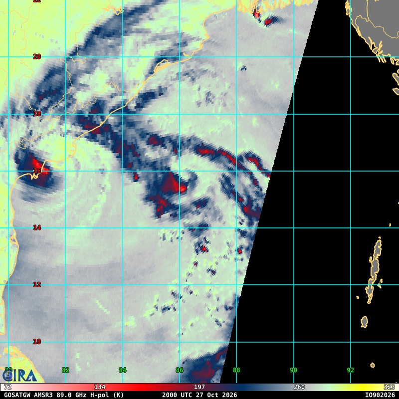
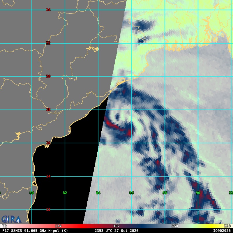
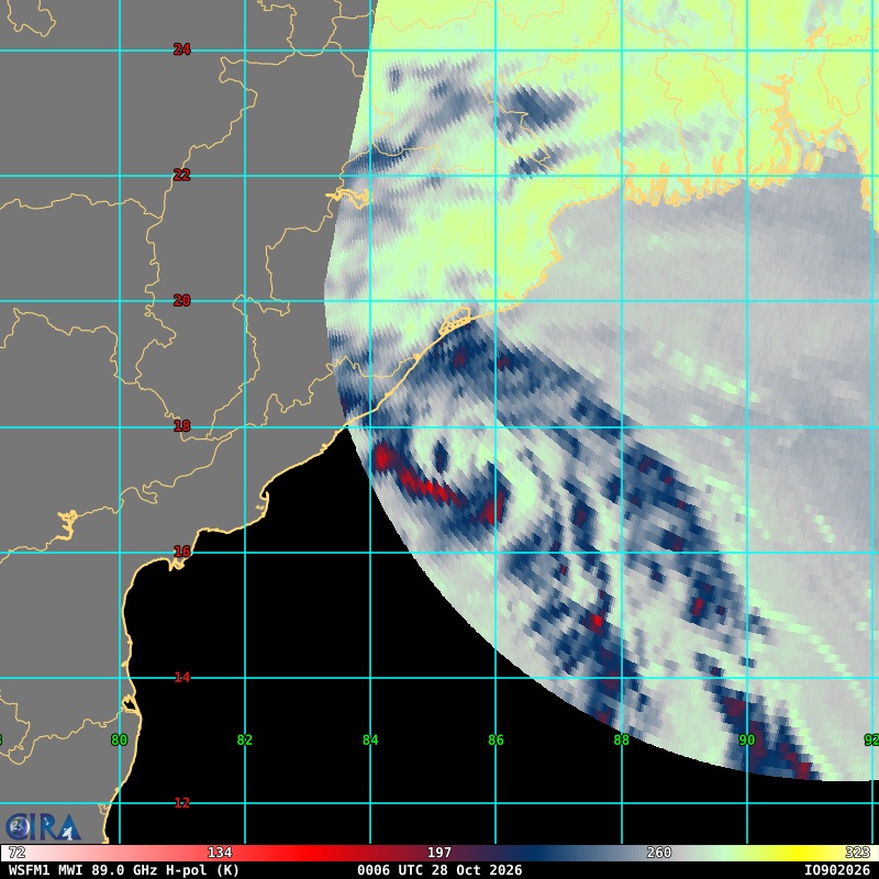
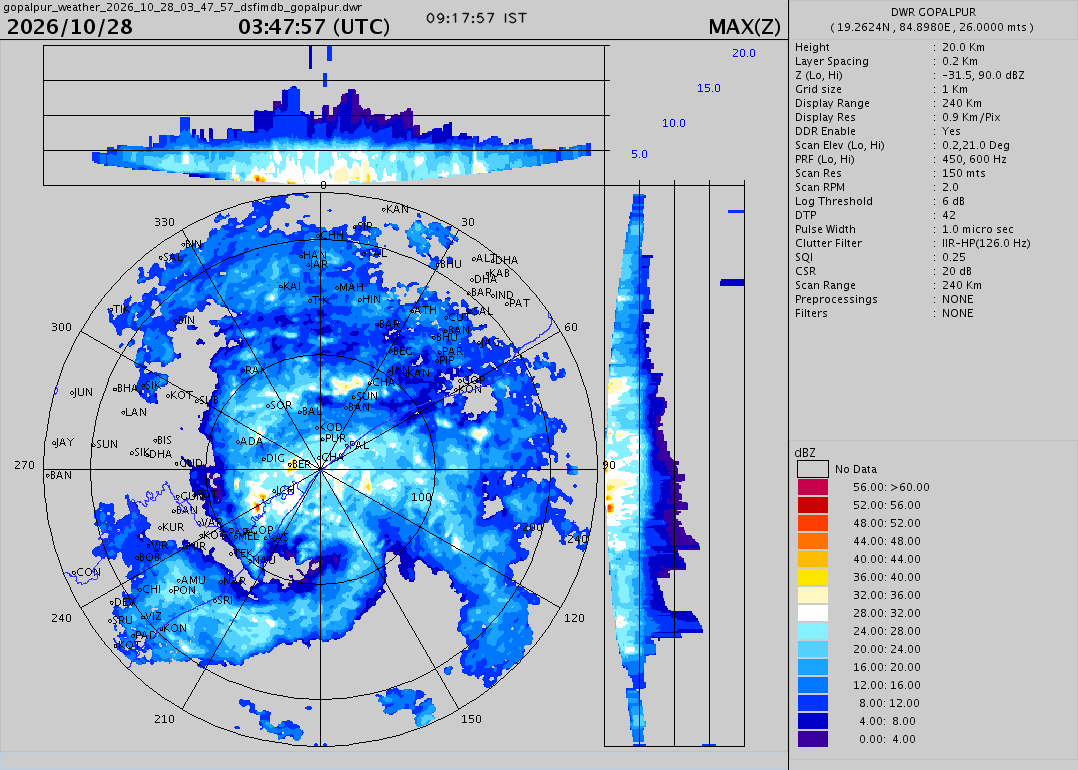
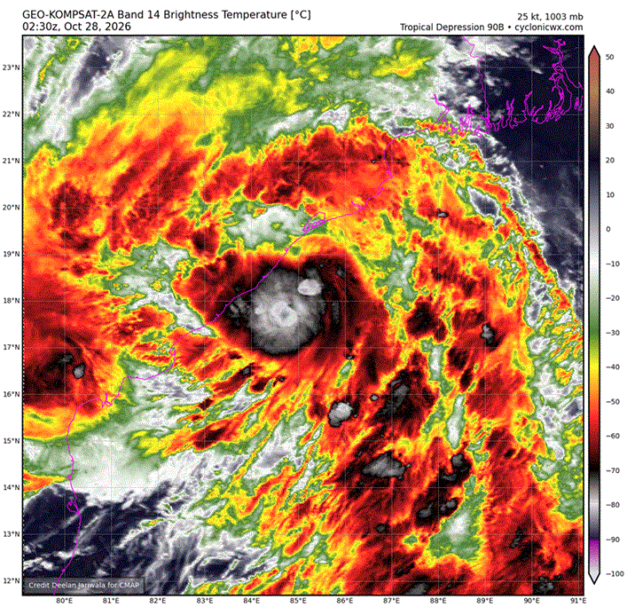
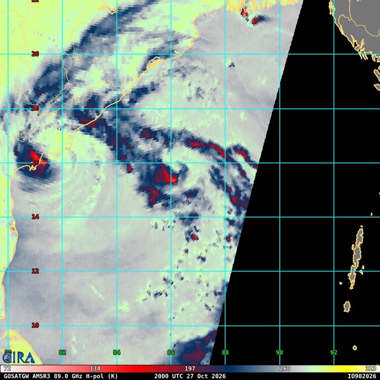
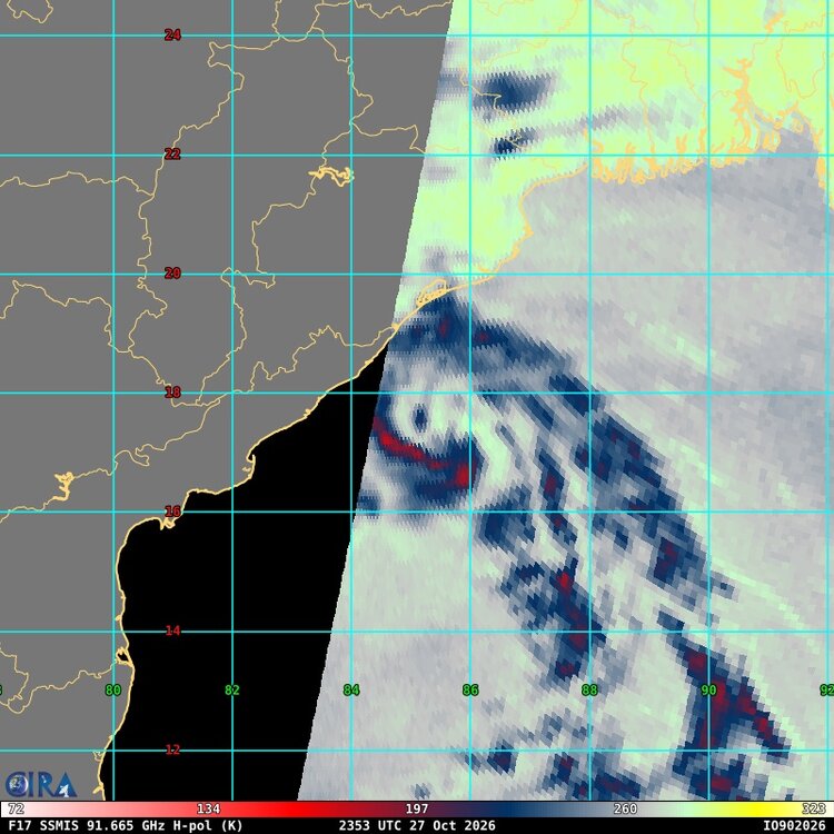
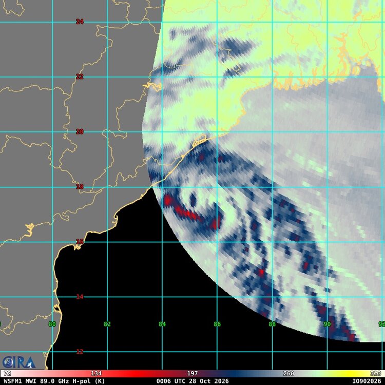
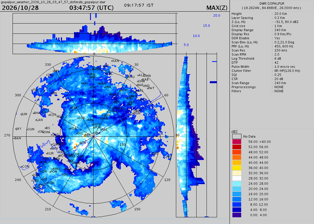
 It seems the disturbance NE of Arnab (90B) has quite the organization and IMHO is a minimal TS as it is about to make landfall as I type this. 3 microwave passes since 27/2000z clearly show a well-defined center w/ impressive curved banding (attached). Nascent CDO w/ cloud tops as cold as -87 C and a fairly quick NW motion would support minimal TS-force winds. Radar shows a well-defined system at landfall. Look a the amended 03z TWO update from JTWC. See below. "Dissipated?" I find that disingenuous and a lie. Yes, I know JTWC is not the RSMC and IMD takes care of it, but it just goes to show the issues outside NHC's AOR w/ "shorties" not counted still these days. And sometimes they are not just weaksystems these shorties! Either way, locally there would be sig impacts where 90B makes landfall. Is that not important? If this was NHC AOR, they would have declared it a TC, and I would agree 100%. It is what it is! ABIO10 PGTW 280300 MSGID/GENADMIN/JOINT TYPHOON WRNCEN PEARL HARBOR HI// SUBJ/SIGNIFICANT TROPICAL WEATHER ADVISORY FOR THE INDIAN OCEAN REISSUED/280300Z-281800ZOCT2026// REF/A/MSG/JOINT TYPHOON WRNCEN PEARL HARBOR HI/280152ZOCT2026// AMPN/REF A IS A TROPICAL CYCLONE WARNING.// RMKS/ 1. NORTH INDIAN OCEAN AREA (MALAY PENINSULA WEST TO COAST OF AFRICA): A. TROPICAL CYCLONE SUMMARY: (1) AT 28OCT26 0000Z, TROPICAL CYCLONE 02B (ARNAB) WAS LOCATED NEAR 16.2N 81.6E, APPROXIMATELY 543 NM SOUTHWEST OF KOLKATA, INDIA, AND HAD TRACKED SOUTHWARD AT 02 KNOTS OVER THE PAST SIX HOURS. MAXIMUM SUSTAINED SURFACE WINDS WERE ESTIMATED AT 65 KNOTS GUSTING TO 80 KNOTS. SEE REF A (WTIO31 PGTW 280300) FOR FURTHER DETAILS. (2) NO OTHER TROPICAL CYCLONES. B. TROPICAL DISTURBANCE SUMMARY: (1) THE AREA OF CONVECTION (INVEST 90B) PREVIOUSLY LOCATED NEAR 17.7N 85.1E HAS DISSIPATED AND IS NO LONGER SUSPECT FOR THE DEVELOPMENT OF A SIGNIFICANT TROPICAL CYCLONE IN THE NEXT 24 HOURS. (2) NO OTHER SUSPECT AREAS. C. SUBTROPICAL SYSTEM SUMMARY: NONE. 2. SOUTH INDIAN OCEAN AREA (135E WEST TO COAST OF AFRICA): A. TROPICAL CYCLONE SUMMARY: NONE. B. TROPICAL DISTURBANCE SUMMARY: NONE. C. SUBTROPICAL SYSTEM SUMMARY: NONE. 3. JUSTIFICATION FOR REISSUE: DISSIPATED AREA IN PARA. 1.B.(1).// NNNN
-
https://zenithindusrx.shop/# medication online