All Activity
- Past hour
-

First Winter Storm to kickoff 2025-26 Winter season
ineedsnow replied to Baroclinic Zone's topic in New England
.thumb.png.19abb954e3091f7fab0e70d77426c23b.png)
-
First Winter Storm to kickoff 2025-26 Winter season
ineedsnow replied to Baroclinic Zone's topic in New England
6z GFS not backing down maybe a slight shift south -

First Winter Storm to kickoff 2025-26 Winter season
moneypitmike replied to Baroclinic Zone's topic in New England
Tossing NAM's, this looks increasingly like it will be a pretty minor event in Maine unless we can get some type of enhancements. -

First Winter Storm to kickoff 2025-26 Winter season
Snowcrazed71 replied to Baroclinic Zone's topic in New England
Shoot.. even into my knees of the woods just west of Hartford brings a healthy amount of Snow. -
First Winter Storm to kickoff 2025-26 Winter season
Snowcrazed71 replied to Baroclinic Zone's topic in New England
Well... That is a big change! ( And It is within its wheelhouse as far as the start time ). Curious how the other models follow suite this morning. -
6z hrrr and Nam look decent for north crew. Nam finally folded.
-
First Winter Storm to kickoff 2025-26 Winter season
ineedsnow replied to Baroclinic Zone's topic in New England
Thinking 6 to 9 of heavy wet snow here.. maybe break 10 if im lucky - Today
-
 This continues to be a highly interesting storm to track. Multiple models have the rain/snow line within 10 miles north or south of my house. The line seems to flip with each run. For 06z I have been NAMed. I do agree with your statement about less surprises however this storm certainly looks to be a good test of model precision.
 -

First Winter Storm to kickoff 2025-26 Winter season
ORH_wxman replied to Baroclinic Zone's topic in New England
3k is pretty similar but not as crazy prolific. Still a decent area of 12”+ -
First Winter Storm to kickoff 2025-26 Winter season
ORH_wxman replied to Baroclinic Zone's topic in New England
Gives ORH 2 feet, lol. What a model. -
First Winter Storm to kickoff 2025-26 Winter season
ineedsnow replied to Baroclinic Zone's topic in New England
.thumb.png.81f4907d23098618e6da51144cf76b17.png)
-
First Winter Storm to kickoff 2025-26 Winter season
ineedsnow replied to Baroclinic Zone's topic in New England
ya 6z NAM has a ton of qpf -
First Winter Storm to kickoff 2025-26 Winter season
ORH_wxman replied to Baroclinic Zone's topic in New England
We’re gonna get NAM’d this run. -
First Winter Storm to kickoff 2025-26 Winter season
ineedsnow replied to Baroclinic Zone's topic in New England
still has that dual low -

First Winter Storm to kickoff 2025-26 Winter season
dendrite replied to Baroclinic Zone's topic in New England
Euro ticked north/warmer -

First Winter Storm to kickoff 2025-26 Winter season
weathafella replied to Baroclinic Zone's topic in New England
The euro vs others is reminiscent of December 2003 albeit with not nearly the potential impact. Euro won but it was the absolute king then. -

Pittsburgh PA Fall 2025 Thread
blackngoldrules replied to TheClimateChanger's topic in Upstate New York/Pennsylvania
Winter Weather Advisory URGENT - WINTER WEATHER MESSAGE National Weather Service Pittsburgh PA 109 AM EST Mon Dec 1 2025 OHZ039>041-048>050-057>059-068-069-PAZ007>009-013>016-020>022-029- 031-073-075-077-078-WVZ001>004-012-021-509-011700- /O.NEW.KPBZ.WW.Y.0022.251202T0500Z-251202T1800Z/ Tuscarawas-Carroll-Columbiana-Coshocton-Harrison-Jefferson OH- Muskingum-Guernsey-Belmont-Noble-Monroe-Mercer-Venango-Forest- Lawrence-Butler-Clarion-Jefferson PA-Beaver-Allegheny-Armstrong- Washington-Greene-Westmoreland-Fayette-Indiana- Higher Elevations of Indiana-Hancock-Brooke-Ohio-Marshall-Wetzel- Marion-Monongalia- Including the cities of Beaver Falls, St. Clairsville, Butler, Ford City, Caldwell, Columbiana, New Philadelphia, Oil City, Waynesburg, Brookville, Franklin, Latrobe, Ellwood City, Murrysville, Ambridge, Pittsburgh Metro Area, Salem, Coshocton, Malvern, Zanesville, New Castle, New Martinsville, Monaca, Greensburg, Uniontown, Wellsburg, East Liverpool, Canonsburg, Tionesta, Indiana, Fairmont, Steubenville, Hermitage, Cambridge, Woodsfield, Washington, Follansbee, Armagh, Dover, Carrollton, Morgantown, Cadiz, New Kensington, Monessen, Grove City, Moundsville, Martins Ferry, Lower Burrell, Aliquippa, Punxsutawney, Kittanning, Sharon, Wheeling, Clarion, and Weirton 109 AM EST Mon Dec 1 2025 ...WINTER WEATHER ADVISORY IN EFFECT FROM MIDNIGHT TONIGHT TO 1 PM EST TUESDAY... * WHAT...Snow expected. Total snow accumulations between 2 and 5 inches. * WHERE...Portions of east central Ohio, northwest, southwest, and western Pennsylvania, and northern and the northern panhandle of West Virginia. * WHEN...From midnight tonight to 1 PM EST Tuesday. * IMPACTS...Plan on slippery road conditions. The hazardous conditions will impact the Tuesday morning commute. PRECAUTIONARY/PREPAREDNESS ACTIONS... Please report snow or ice accumulations by calling 412-262-1988, posting to the NWS Pittsburgh Facebook page, or using X @NWSPittsburgh. -

First Winter Storm to kickoff 2025-26 Winter season
WinterWolf replied to Baroclinic Zone's topic in New England
Euro? -
URGENT - WINTER WEATHER MESSAGE National Weather Service Baltimore MD/Washington DC 1238 AM EST Mon Dec 1 2025 ...FIRST WIDESPREAD WINTER EVENT OF THE SEASON... .Precipitation is expected to overspread the area after midnight tonight from southwest to northeast. While precipitation is likely to start as snow areawide, it is expected to mix with and change to sleet and freezing rain for most of the area. Locations along and south of US-50/I-66 likely end the event as rain as temperatures warm through the morning. Areas along the Mason-Dixon are most likely to remain all snow through the event, but that remains uncertain given exact low track. The Tuesday morning commute could be impacted for all areas in the Winter Weather Advisory. Updates to the forecast are likely, so please remain weather aware for the first widespread winter event of the season. VAZ025>031-036>040-050-051-501-503>505-507-508-WVZ050-055-502-505- 506-011345- /O.NEW.KLWX.WW.Y.0022.251202T0600Z-251202T1700Z/ Augusta-Rockingham-Shenandoah-Frederick VA-Page-Warren-Clarke- Nelson-Albemarle-Greene-Madison-Rappahannock-Orange-Culpeper- Northern Fauquier-Western Highland-Eastern Highland-Western Loudoun-Northern Virginia Blue Ridge-Central Virginia Blue Ridge- Hampshire-Hardy-Eastern Grant-Western Pendleton-Eastern Pendleton- 1238 AM EST Mon Dec 1 2025 ...WINTER WEATHER ADVISORY IN EFFECT FROM 1 AM TO NOON EST TUESDAY... * WHAT...Mixed precipitation expected, with a majority of the precipitation expected in the form of freezing rain. Total snow and sleet accumulations up to one inch and ice accumulations around one tenth of an inch, with upwards of two tenths of an inch possible on the higher ridges. * WHERE...Portions of central, northern, northwest, and western Virginia and eastern West Virginia. * WHEN...From 1 AM to noon EST Tuesday. * IMPACTS...Plan on slippery road conditions. The hazardous conditions could impact the Tuesday morning commute. * ADDITIONAL DETAILS...Precipitation is expected to overspread the area after after midnight tonight. Precipitation is expected to start briefly as snow before mixing with and changing over to sleet and freezing rain.
-
URGENT - WINTER WEATHER MESSAGE National Weather Service Baltimore MD/Washington DC 1238 AM EST Mon Dec 1 2025 ...FIRST WIDESPREAD WINTER EVENT OF THE SEASON... .Precipitation is expected to overspread the area after midnight tonight from southwest to northeast. While precipitation is likely to start as snow areawide, it is expected to mix with and change to sleet and freezing rain for most of the area. Locations along and south of US-50/I-66 likely end the event as rain as temperatures warm through the morning. Areas along the Mason-Dixon are most likely to remain all snow through the event, but that remains uncertain given exact low track. The Tuesday morning commute could be impacted for all areas in the Winter Weather Advisory. Updates to the forecast are likely, so please remain weather aware for the first widespread winter event of the season. MDZ501-502-509-510-WVZ501-503-504-011345- /O.NEW.KLWX.WW.Y.0022.251202T0600Z-251202T1800Z/ Extreme Western Allegany-Central and Eastern Allegany-Western Garrett-Eastern Garrett-Western Grant-Western Mineral-Eastern Mineral- 1238 AM EST Mon Dec 1 2025 ...WINTER WEATHER ADVISORY IN EFFECT FROM 1 AM TO 1 PM EST TUESDAY... * WHAT...Mixed precipitation expected. Total snow and sleet accumulations between 1 and 3 inches with locally up to 4 inches near the Mason-Dixon. Ice accumulations up to one tenth of an inch. * WHERE...Portions of western Maryland and eastern West Virginia. * WHEN...From 1 AM to 1 PM EST Tuesday. * IMPACTS...Plan on slippery road conditions. The hazardous conditions will likely impact the Tuesday morning commute. * ADDITIONAL DETAILS...Precipitation is expected to overspread the area after after midnight tonight. Precipitation is expected to start as snow before mixing with sleet and freezing rain. Should precipitation stay all snow or snow for a longer period of time, locally higher snowfall amounts would be possible. Additional upslope snow showers are expected Tuesday afternoon for locations west of the Allegheny Front which could produce a coating to inch or so of additional accumulation.
-
URGENT - WINTER WEATHER MESSAGE National Weather Service Baltimore MD/Washington DC 1238 AM EST Mon Dec 1 2025 ...FIRST WIDESPREAD WINTER EVENT OF THE SEASON... .Precipitation is expected to overspread the area after midnight tonight from southwest to northeast. While precipitation is likely to start as snow areawide, it is expected to mix with and change to sleet and freezing rain for most of the area. Locations along and south of US-50/I-66 likely end the event as rain as temperatures warm through the morning. Areas along the Mason-Dixon are most likely to remain all snow through the event, but that remains uncertain given exact low track. The Tuesday morning commute could be impacted for all areas in the Winter Weather Advisory. Updates to the forecast are likely, so please remain weather aware for the first widespread winter event of the season. MDZ003>006-507-WVZ051>053-011345- /O.NEW.KLWX.WW.Y.0022.251202T0800Z-251202T1800Z/ Washington-Frederick MD-Carroll-Northern Baltimore-Northwest Harford-Morgan-Berkeley-Jefferson- 1238 AM EST Mon Dec 1 2025 ...WINTER WEATHER ADVISORY IN EFFECT FROM 3 AM TO 1 PM EST TUESDAY... * WHAT...Mixed precipitation expected. Total snow and sleet accumulations of 1 to 2 inches, with locally higher amounts upwards of 4 inches possible near the Mason-Dixon and higher elevations such as Parr`s Ridge. Ice accumulations around up to one tenth of an inch. * WHERE...Portions of north central and northern Maryland and panhandle West Virginia. * WHEN...From 3 AM to 1 PM EST Tuesday. * IMPACTS...Plan on slippery road conditions. The hazardous conditions could impact the Tuesday morning commute. * ADDITIONAL DETAILS...Precipitation is expected to overspread the area after after midnight tonight. Precipitation is expected to start as snow before mixing with sleet and freezing rain. Should precipitation stay all snow or snow for a longer period of time, locally higher snowfall amounts would be possible.
-

December 2025 Short/Medium Range Forecast Thread
John1122 replied to John1122's topic in Tennessee Valley
Now the GFS is showing what the Euro did yesterday, a change to heavy snow by Tuesday morning from the Plateau and west along the Tn/Ky border counties. Cranks out 2 inches imby. The HRRR is more vertical with it's bands of snow and further west, deep into Western areas of the forum. -
Ready for another white knuckle tracking season.
-

2025-2026 ENSO
brooklynwx99 replied to 40/70 Benchmark's topic in Weather Forecasting and Discussion
lol, GEFS capitulating. much lower AO, -NAO signal strengthening too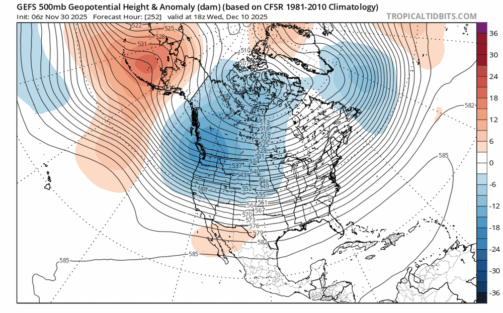
-
Being on the northern portion of the system you kind of worry this could bump a bit south and be just a dog turd duster, but we seem to be holding in the 0.12-0.17 range for precip. 1-2" refresher looking pretty likely here.
.png.d9cd44cee1defd7f75f8410fd3c77320.png)


.png.3d060b410ecbd16bc347793b14a1d319.png)


