All Activity
- Past hour
-
New beer incoming?
-
Save Treehouse!!
-
That’s what she said
-
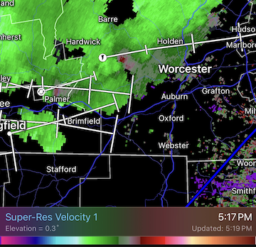
I see a rotational signature near Fiskdale
-
Heavy rain just started here in Auburn. Let’s see what happens… .
-
And somethin as well near Sturbridge
-
why are the polygons so huge?
-
Chuck: If that central trough digs deep enough to put us in a long-wave southwesterly flow, that will be good.
-
Storms incoming
-

E PA/NJ/DE Summer 2026 Obs/Discussion
MGorse replied to PhiEaglesfan712's topic in Philadelphia Region
Yup, it definitely mixed higher than expected today and thus stronger winds. -
Mostly torrential rain right now, but really to head downstairs if needed. Gusty, but no more than earlier today. Not surprised if something happened in Paxton area--it looked pretty strong on velocity in that area.
-
The trailing tor warned cell has a better couplet
-
Line came thru here about 10 min ago ...now light rain entrails. Had a few minutes of 35 mph gusts under a gnarly looking shelf base, then 10 minute of moderate to heavy rain. Not a single lightning flash. Not a single rumble of thunder. Not even in the distance.
-
New warning up
-
Actually I think there was a brief TDS just southwest of Paxton
-
Thought north of rte 2 was where it was at today?
-
That cell back in Warren is a bit amped too
-
The one near Warren looks good as well
-
Decent wind with that line that came through Greenfield at 4 PM. Maybe 10 minutes of heavy rain but definitely some gusts that took down some small branches, etc. Sun is out now.
-
Low CCs but not quite enough for TDS
-
Nice having our phones go off.
-
And we're warned. The storm track going right over my house. Didn't have to chase anything lol
-
Tor warned just east of there. Probably could’ve went further back for that cell too
-
Tor warning a bit to my south. Oakham area
-
Now warned!