All Activity
- Past hour
-
Not sure if you’re familiar with this place, but they have ripe pawpaws starting and some days with PYO tours.
-
September 2025 OBS-Discussion centered NYC subforum
SnoSki14 replied to wdrag's topic in New York City Metro
Cool mornings plus dry conditions -
Yeah I’ll take anything at this point…even a wedged all day -RADZ fest.
-
Concord got an inch last week. I was down there Saturday and you could tell…the lawns greened back up and there were puddles. But in town here looks like Arizona. I’m afraid to water my potted trees with how slow the well is to refill. Hopefully Fri/Sat delivers something substantial.
-

September 2025 OBS-Discussion centered NYC subforum
Stormlover74 replied to wdrag's topic in New York City Metro
Noticing some leaf color change already -
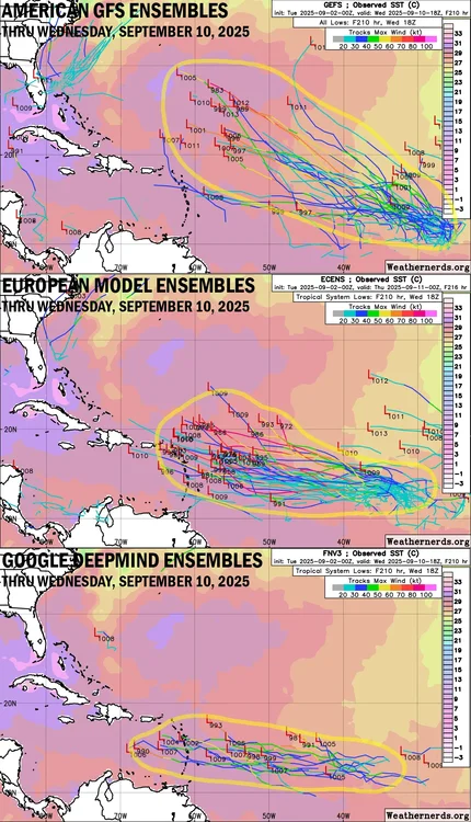
Anything’s possible. It could blow up in especially the W half of the Caribbean if it gets to the E Car pretty weak. By the way, note that per Deepmind that the faster members are more of a threat to the Caribbean/further S.
-
can we just get one strong low with widespread rain
-
We were racking it up in the first half with all of those wet weekends. 1 rain event in 5 weeks is rough though.
-
Road the Northern Trail yesterday from Franklin up to Danbury and back - lots of leaves on the ground with many others looking they will soon be on the ground.
-
About as exciting as that
-
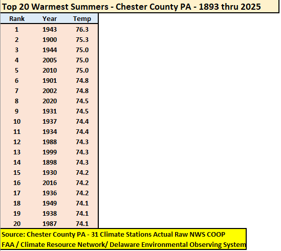
At an overall average temperature of 73.0 degrees the summer of 2025 finished as the 54th warmest summer across 133 years of records in the Philly burbs of Chester County PA. The top 20 warmest summers are listed below.
-

E PA/NJ/DE Summer 2025 Obs/Discussion
ChescoWx replied to Hurricane Agnes's topic in Philadelphia Region
At an overall average temperature of 73.0 degrees the summer of 2025 finished as the 54th warmest summer across 133 years of records in the Philly burbs of Chester County PA. The top 20 warmest summers are listed below. -
I'm saving this for future powerpoints. Thanks.
-
changed + if she does track to the caribbean could she blow up or will she stay weak
-

Central & Eastern Pacific Thread
BarryStantonGBP replied to Windspeed's topic in Tropical Headquarters
WHO THE FUG IS HILDA -
2025-2026 ENSO
PhiEaglesfan712 replied to 40/70 Benchmark's topic in Weather Forecasting and Discussion
Yeah, it's about time to face the music and accept that this season may be a below average activity hurricane season. Keep in mind, we're at the point when Felix hit. No major storms formed after that point that year, and that was a strong la nina. A one-storm wonder season is not even unprecedented. Andrew hit in August, like Erin, and there wasn't another major storm the rest of the season. -
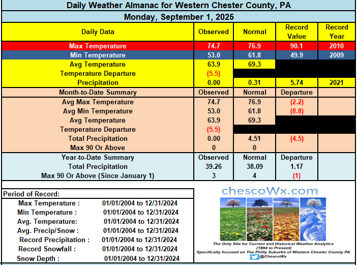
Our beautiful start to September continues with some of our lower valley location recording their 8th straight morning with low temperatures in the 40's! Remarkable for the end of August and the beginning of September. We should see somewhat warmer temperatures this week getting us to slightly above normal high temperatures by Thursday and Friday. Another cold front crosses the area by the end of the week and next week looks like a return to well below normal temperatures again. Our best rain chance in a few weeks looks possible by Thursday night into Friday morning with the aforementioned cold front. We will take whatever we can get at this point.
-

E PA/NJ/DE Summer 2025 Obs/Discussion
ChescoWx replied to Hurricane Agnes's topic in Philadelphia Region
Our beautiful start to September continues with some of our lower valley location recording their 8th straight morning with low temperatures in the 40's! Remarkable for the end of August and the beginning of September. We should see somewhat warmer temperatures this week getting us to slightly above normal high temperatures by Thursday and Friday. Another cold front crosses the area by the end of the week and next week looks like a return to well below normal temperatures again. Our best rain chance in a few weeks looks possible by Thursday night into Friday morning with the aforementioned cold front. We will take whatever we can get at this point. - Today
-
The E MDR AOI is now red. This from Michael Lowry is a bit concerning at least for the E Caribbean: Models all over the map Forecast models generally agree on development, but the timing of and placement of development vary wildly, which of course affect the future track. On the one hand the American GFS is quick to develop the system this week along the northern lobe of the tropical wave and as a result move it farther north and turn it quickly into the Atlantic for next week, missing the islands to the north. On the other hand, the European model and Google DeepMind’s newest machine learning-based model that performed well during Hurricane Erin, take some time to develop the wave and do so on the southern side, which not surprisingly favors a track farther south and west and toward the eastern Caribbean for the middle part of next week. ——————— My concern is that Google Deepmind ensembles, which I know little about, did best with Erin per Lowry. As you can see, its 0Z 9/2 run has 6 of its members from the E MDR AEW in a very dangerous location. What I don’t know is how many total members it has. Lowry’s diagram makes it look like most members go toward the Caribbean, but there are only 6 that actually get there by hour 210. Many are slower (still well E) and 4 of them are turning WNW to NW (at the top of his yellow circle) and we can’t see where they go after hour 210. Also, there are two that are just starting to sharply recurve well E of the Caribbean but still within the MDR. But regardless, this ensemble’s avg trajectory does look more dangerous than the EPS and is totally different from the GEFS. @BarryStantonGBPPlease change this from 10/60 to 30/70. Thanks.
-
Solid garden variety storms rolling through the metro this morning. Needed the moisture after a couple dry weeks.
-
This next one has a better chance than Erin did, relative to the outlook range, spanning the eastern continent and adjacent SW Atlantic Basin. Note, better chance does not mean this: The CPC's handling of the PNA index has it rising positive, while the NAO is bucking for a vague negative. That's all but a 101 requirement, particularly if the latter is over the western limb. To soon to know if that's the case but just numerically, this is a better canvas. Erin never even had an easel. Anyway, the idea of a warm up mid month still does not have a lot of legs in the index spread. It matters. If we succeed in doing so, this idea dries up. Can't really have both. A pattern relaxation will likely ensue beyond this trough anomaly deal through the Lakes. The operational runs will tend to bounce the pattern aggressively the other direction, and by that I mean too much. The index/PNA rising seems in conflict here. I could see the flow relaxing, and by virtue of that... yeah, warming, but uuusually, a rising PNA doesn't set the table for an eastern/WAR -like response. It's interesting... a period of some competing indicators. I tend to lean on the ensembles, however. So, meanwhile, the MDR reactivates here over this week. Any TC born out of that may find a position not as polarward as the GFS is attempting by circa D6/7. This is also a known bias at long leads regarding operational guidance, definitely with that particular model. Having too much "beta drift" (sus therein), it likes to move these systems into the Sargasso Sea while maintaining a west track at like 36 N.. Compensating for these behavior biases may see a TC closer to the NE Windward Islands by D6 or 7 ... which also fits the EPS, although I that forecast system seems a little weak considering the favorable main metrics of lowering shear, ample OHC, and lowering SAL. All these facets ... mmm, I won't calling them compelling just yet. Too strong. But, I'm willing to actually look at the models this time. LOL
-
-

2025 Atlantic Hurricane Season
BarryStantonGBP replied to BarryStantonGBP's topic in Tropical Headquarters
no wonder models had a wcar/gulf threat it'll go on and off for now -
EP, 12, 2025090212, , BEST, 0, 179N, 1074W, 35, 1005, TS, 34, NEQ, 30, 20, 0, 20, 1009, 100, 30, 0, 0, E, 0, , 0, 0, LORENA, S, 0, , 0, 0, 0, 0, genesis-num, 021,
-
we used to get cold fronts with an inch of rain


