All Activity
- Past hour
-
.thumb.png.4150b06c63a21f61052e47a612bf1818.png)
White Christmas Miracle? December 23-24th
HIPPYVALLEY replied to Baroclinic Zone's topic in New England
.25" here, not sure that will last through tomorrow. This could be a rare non-white Christmas here. -
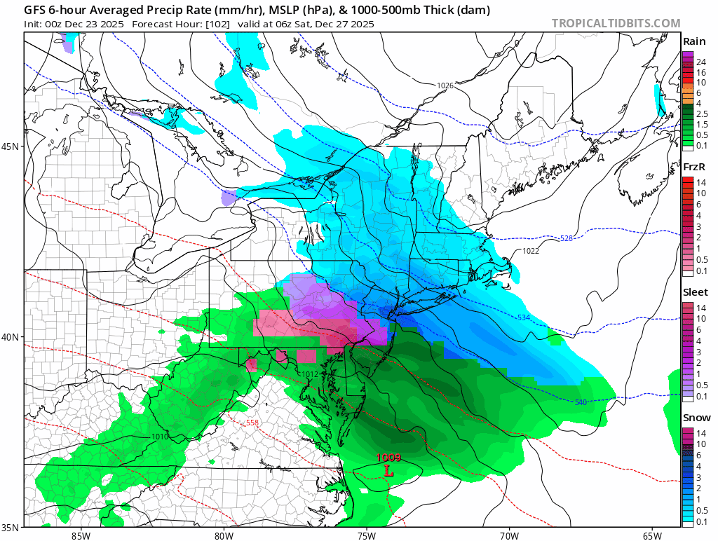
0z GFS decent shift north.
-
It has been consistent. Could still be wrong but other models seem to be trending colder
-
+SN, 23/21°F, 4" down
-
Sign me up
-
i guess that would be the ceiling @Stormlover74great to see. perfect track
-
.thumb.png.3d749c99dda6ed4ad31467cc2d84b633.png)
-

White Christmas Miracle? December 23-24th
ORH_wxman replied to Baroclinic Zone's topic in New England
One of the rare 11th hour breaks we’ve gotten in the last few years. Event somehow got its act together just enough this evening to make it pretty nice. Would be nice if we could get a region-wide good break soon. -
We'll see. That was a good GFS run. If this blocking really happens this can work out and we're getting into reality range.
-

December 2025 regional war/obs/disco thread
Ginx snewx replied to Torch Tiger's topic in New England
Not so small and look at the trend.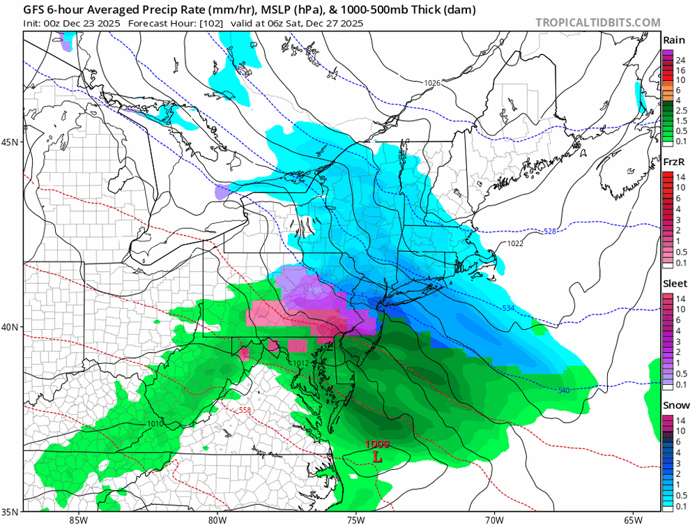
-
More
-

White Christmas Miracle? December 23-24th
40/70 Benchmark replied to Baroclinic Zone's topic in New England
2.25" Great growth -

December 2025 regional war/obs/disco thread
TauntonBlizzard2013 replied to Torch Tiger's topic in New England
Small bump north gfs. Extremely SW CT good hit -
GFS is 4-7 inches
-
3.0", still snowing pretty good
-
Yeah there were 2 events in February 2019 where the precipitation waw delayed by hours and all we ended up with was like 2” of snow/sleet from each one as opposed to the 3-5” expected . By the time the snow came, it shortly went over to sleet. This is increasingly reminding me of those because I’m sure the north trend isn’t done either
-

2025-2026 ENSO
Stormchaserchuck1 replied to 40/70 Benchmark's topic in Weather Forecasting and Discussion
Oct 1-30: +60 days Nov 1-15: +50 days Nov 15-30: +45 days Dec 1-15: +40 days Dec 15-30: +35 days Jan 1-15 +30 days Jan 15-30 +25 days Feb 1-20: +20 days Feb 20-March 30: +15 days Apr 1-15: +10 days Something like that.. -
That worked out better than I thought it would because the heavy precip came early before the mid level warmth could ruin it-in these SWFE type setups we need the heavy initial thump. Even in Long Beach there was 4-5" because the snow came in like a wall and piled up. The ones where it gets delayed/comes in shredded you know will disappoint.
-

Central PA Winter 25/26 Discussion and Obs
mahantango#1 replied to MAG5035's topic in Upstate New York/Pennsylvania
We need those winter weather reports from Tamaqua. You matter! -
December 2025 regional war/obs/disco thread
TauntonBlizzard2013 replied to Torch Tiger's topic in New England
Gfs probably going to come north a bit, but it was so far south it’s likely not going to matter -
This reminds me of a winter storm we had last February. All of NYC and LI was under winter storm watch for 4-6” of snow, sleet, and ZR. We were downgraded to winter weather advisory, because only 2-4” fell in the boroughs because of a lot of sleet. Most of Long Island did better, and the either west you went, the more mixing you ran into. Was a solid ice storm for Philly up towards Newark. Cold temps ahead of that storm too, but lots of mid level warmth
-
I don't think so. That was the day my brother and sister-in-law got married. I remember it being 70 and sunny in the morning, maybe a little breezy and cloudy in the afternoon during the ceremony, but no tornado.
-
Larry's an excellent Medium / LR Forecaster.
-
It's really about the mid levels and 700/850 low tracks. Right now the blocking is stout enough that those don't screw us over but I wouldn't say we're out of the woods (around NYC). Look at the soundings. There will definitely be a sleetfest zone in this kind of storm because of those mid level lows going north of them and bringing in the warm air at 750/800mb. Right now that's most of PA down to Philly but have to watch any last minute trend.
-
Can see some of the best forcing developing over where the models had this on radar, These norluns are a nowcast but looks like the models got it right at this time.


.png.a269561677f831e55186d7d4af42e27b.png)