All Activity
- Past hour
-
Low frequency forcing/MJO 5-6-7 still in the same familiar area (around Maritime Continent) as we go further into this month. The Niña background state remains
-

TROPICAL WAVE LOCATED IN CHAD, AFRICA (NOT 96L)
GaWx replied to BarryStantonGBP's topic in Tropical Headquarters
The 12Z UKMET is likely the 1st with a TD from this as it forms in only 114 hours (thus lemon-worthy). After sliding just N of the N Leewards, it ends the run approaching TS strength (33 knts/38 mph winds) 430 miles ENE of PR moving WNW at a pretty brisk 18 mph. Will have to wait for maps to get better idea of whether or not its implying it would likely recurve offshore the Conus NEW TROPICAL CYCLONE FORECAST TO DEVELOP AFTER 114 HOURS FORECAST POSITION AT T+114 : 15.8N 46.0W LEAD CENTRAL MAXIMUM WIND VERIFYING TIME TIME POSITION PRESSURE (MB) SPEED (KNOTS) -------------- ---- -------- ------------- ------------- 1200UTC 13.08.2025 120 16.1N 48.2W 1009 28 0000UTC 14.08.2025 132 17.8N 51.6W 1009 27 1200UTC 14.08.2025 144 18.9N 54.9W 1009 29 0000UTC 15.08.2025 156 20.3N 57.7W 1009 30 1200UTC 15.08.2025 168 21.4N 60.9W 1007 33 -
We are extremely overdue, not counting tropical storm meh-nri. Every season we have model runs showing impacts which almost inevitably whiff. I remember Erika, Lee, Isaias, even Joaquin being shown as threats that never ended up materializing. But the historical precedent is there for big hits as unlikely as they are, and the east coast is definitely more at risk this year than the past few gulf-heavy seasons.
-
i had a nest next to my garden last year and never got stung. they would land on me once in a while to check me out but if you're cool about it they don't bother you
-
I would have totally expected Virginia to be higher on the list if for no other reason than more area.
-
Wow. Sky seems much clearer here today than the last few days.
-

Occasional Thoughts on Climate Change
TheClimateChanger replied to donsutherland1's topic in Climate Change
Something to ponder that may go against the general narrative. Not only are the PRISM estimates routinely coming in higher, but nClimDiv continues to demonstrate a cooling bias relative to USCRN and it's really becoming rather significant in recent months. The July anomaly was +.21F higher for USCRN, which makes a big difference in the rankings when each hundredth of a degree matters. -
i may be overt tree hugging in this .. clearly in the minority, but unless the bee's nest is critically located - which most realistically aren't - leave 'em the f* alone. they are hugely beneficial to the local ecological health. from pollinator species, to insect carnivores ( yellows and wasps - ) they do vastly more good than harm honey bees can even be moved by calling a specialist. if a bald face hornet's nest is clinging to the underside of the front door awning, than okay. but in the past, i just avoid them unless it's more obviously necessary. seems like some people wanna go after them just because it is there. hoping that's not the case -
-
Tropical Storm Henriette Discussion Number 18 NWS Central Pacific Hurricane Center Honolulu HI EP082025 Issued by NWS National Hurricane Center Miami FL 500 AM HST Fri Aug 08 2025 Henriette has failed to produce deep convection for about 12 hours now. The latest subjective Dvorak estimates are 25 kt from JTWC and too weak to classify from SAB and PHFO. Recent objective intensity estimates range from 25 to 40 kt. An earlier ASCAT pass from 0535 UTC showed a large area of 30-33 kt vectors on the north side of Henriette. Henriette will be maintained as a 35-kt tropical storm for this advisory, but it could degenerate to a post-tropical remnant low at any time today. The cyclone is moving just north of due west at 280/15 kt. A turn to the west-northwest is expected soon as the cyclone tracks along the southwestern periphery of a subtropical ridge to its northeast. A turn toward the northwest is forecast late this weekend into early next week as Henriette becomes steered between an amplifying longwave trough northwest of Hawaii and the subtropical ridge to its northeast. The NHC track forecast is nearly identical to the previous one and is in good agreement with the tightly clustered consensus aids. Confidence remains high that Henriette will remain far to the north of Hawaii. Henriette is over 24C sea-surface temperatures (SSTs) and is embedded within a dry airmass. These cold SSTs are expected to persist along the cyclone's track for another 12 to 24 h. If Henriette doesn't generate organized convection soon, it could degenerate to a remnant low today, and this is explicitly shown in the NHC forecast Beyond 24 h, Henriette (or its remnants) will encounter progressively warmer water temperatures over the weekend, peaking around 26-27C in about 3 days. Upper-level temperatures are also expected to decrease in a couple of days as the aforementioned trough approaches Henriette, which would increase instability. These factors, along with relatively low shear, will likely allow Henriette to restrengthen later this weekend into early next week, as depicted by most of the models. The NHC intensity forecast is at the low end of the guidance envelope through 36 h, and at the high end of the guidance at 72-96 h. Beyond day 4, wind shear from the longwave trough and cooling SSTs should lead to steady weakening as Henriette moves farther into the mid-latitudes. Even if Henriette becomes post-tropical today, given the high likelihood of regeneration back into a tropical cyclone and subsequent restrengthening, NHC plans on maintaining advisories during the post-tropical phase. FORECAST POSITIONS AND MAX WINDS INIT 08/1500Z 19.7N 141.5W 35 KT 40 MPH 12H 09/0000Z 20.3N 143.7W 30 KT 35 MPH...POST-TROP/REMNT LOW 24H 09/1200Z 21.3N 146.3W 30 KT 35 MPH...POST-TROP/REMNT LOW 36H 10/0000Z 22.6N 148.7W 35 KT 40 MPH...TROPICAL CYCLONE 48H 10/1200Z 24.1N 150.9W 45 KT 50 MPH 60H 11/0000Z 25.9N 153.2W 55 KT 65 MPH 72H 11/1200Z 27.9N 155.7W 65 KT 75 MPH 96H 12/1200Z 32.3N 160.4W 65 KT 75 MPH 120H 13/1200Z 37.1N 165.1W 50 KT 60 MPH $$ Forecaster Hagen
-
-
Occasional Thoughts on Climate Change
TheClimateChanger replied to donsutherland1's topic in Climate Change
-
I mentioned how the shadows looked funky with the smoke.
-

2025 Atlantic Hurricane Season
BarryStantonGBP replied to BarryStantonGBP's topic in Tropical Headquarters
-
WELCOME ABOARD INVEST 96L (0/50)
BarryStantonGBP replied to BarryStantonGBP's topic in Tropical Headquarters
-
TROPICAL WAVE LOCATED IN CHAD, AFRICA (NOT 96L)
BarryStantonGBP replied to BarryStantonGBP's topic in Tropical Headquarters
-
air quality alert for smoke issued for the entire eastern panhandle of WV.
-
how dare you get told that molotov cocktails are dangerous
-
July 2025 Discussion-OBS - seasonable summer variability
TheClimateChanger replied to wdrag's topic in New York City Metro
Pretty close! Officially checked in at 71.9F, matching 1901 & 1949 for 4th place overall. -
Interesting @Kmlwx https://x.com/Gio_wx/status/1953625408219271370
-
Looking at 850Ts, seems like a subtle shift north with the highest 850 temps on guidance. Might be your classic MHT-lower elevation Maine roaster. Just for Dryslot. A Tamarack Torcher.
-
 NYC came extremely close to having three days of 100+ which is outrageous in this era of foliage blockage and the fact that this happened in August, not July. It still did not match August 1948's three straight days of 100+ but this was the closest we've gotten to since then for three straight 100+ days at NYC in August. Tony could you post the 100+ days in August 1948 at all of these locations please-- I think this was the first month that the sensor at JFK came into operation.
 -
If the Coop is nearby, it's over 400' lower. So makes sense it would be warmer.
-

2025-2026 ENSO
40/70 Benchmark replied to 40/70 Benchmark's topic in Weather Forecasting and Discussion
I understand the limitations of these data at this range, but I don't disagree. -

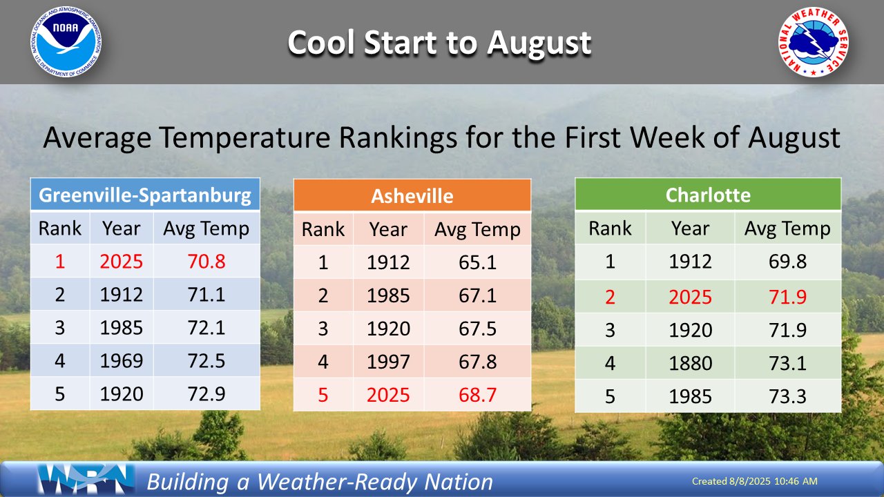
2025 Spring/Summer Mountain Thread
Maggie Valley Steve replied to Maggie Valley Steve's topic in Southeastern States
What an amazing start to August!
-
Yes, you are right. Looks like the NWS must have a coop site nearby too. Looks a little warmer throughout the record than the observatory numbers, maybe lower in elevation?