
All Activity
- Past hour
-

2026-2027 Record-breaking El Nino
raindancewx replied to Stormchaserchuck1's topic in Weather Forecasting and Discussion
Wettest month in ABQ since July 2015. Outside chance we set the record for rain for at least the modern measurement site by month end, something like 4.06". We're at 2.75"+ and plenty more rain is forecast by the end of the month. 1940 and 1997 were the two prior wettest September El Nino months locally, but we've surpassed both. New Mexico is the land of ENSO, so good to see at least the wet signal now showing up robustly. That said, the wettest Septembers here are often East El Nino setups or Modoki La Nina setups, where E Pac is > W Pac for water temp anomalies at the equator. Sept itself is not correlated strongly for precip to 3.4, so several of the top wet months here are La Ninas. -
 dryslot changed their profile photo
 -

October Comes Early: Late September Multi-Hazard Hybrid Storm
HIPPYVALLEY replied to WxWatcher007's topic in New England
They are banned at my kid’s school. -
 https://solmedsdirect.shop/# mexico pharmacy list
 -

Strong Nor'Easter/Hybrid Storm Late September 2026
mgerb replied to Rjay's topic in New York City Metro
Back and forth we go.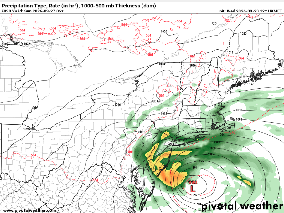
-

Strong Nor'Easter/Hybrid Storm Late September 2026
wthrmn654 replied to Rjay's topic in New York City Metro
Jma is west of 00z lmao yeah I'm going put the phone down and do some yard work with all this variability, no point in wasting brain cells yet when models are all over the place still -

October Comes Early: Late September Multi-Hazard Hybrid Storm
Brewbeer replied to WxWatcher007's topic in New England
not as much fun as bumping this one: -
I think everyone knows where this winter stands. It'll be above average temperatures, especially in December and it is unlikely we get any real sustained periods of frigid temps, save our conception of how the atmosphere behaves in a strong el nino being wrong. It's also a good bet we will have favorable storm tracks and a very active subtropical jet stream to bring in above average precip. That is all we can really say. We can then formulate that this season will be a boom or bust depending on if we get lucky with a shot of cold air at the right time, but we can't speculate on any details of that responsibly. Anything else is extrapolating or doesn't have much climatological backing. That's it. We now just have to wait through at least October, if not November/December, to watch how the atmosphere couples with the oceans.
-
Strong Nor'Easter/Hybrid Storm Late September 2026
wthrmn654 replied to Rjay's topic in New York City Metro
Eastern areas kinda look like more precip though but hard to tell. -
Strong Nor'Easter/Hybrid Storm Late September 2026
wthrmn654 replied to Rjay's topic in New York City Metro
Comparing the 00z to 12zgefs, looking at total precip is nearly identical all the way to NYC from the image I can see not fully zoomed in.. -

Strong Nor'Easter/Hybrid Storm Late September 2026
Snowlover11 replied to Rjay's topic in New York City Metro
I’ll be inside the casino -

October Comes Early: Late September Multi-Hazard Hybrid Storm
weatherwiz replied to WxWatcher007's topic in New England
Folks complain when there is no weather and complain when there is weather to talk about lol. It's almost as if every single weather phenomenon has to be extreme or bust. Everything is meh, meh, meh unless there are 20 tornadoes, trees get blown down all over, snow accumulations exceed 2 feet, winds gust above 60, or half the region is under water. -
 Suddenly the GFS is now correct I see from the usual suspects . Those posts will be fun to bump Saturday in a driving wind and rain storm regionally
 -
Septorcher 2026 Discussion - Endless Summer
dryslot replied to Damage In Tolland's topic in New England
51/43°F, Fall has arrived, Looks like another night in the 30's on tap, Had 4 in the last 10 days. -

October Comes Early: Late September Multi-Hazard Hybrid Storm
Ginx snewx replied to WxWatcher007's topic in New England
TMEH oh man -
But it also means when the real stuff happens everyone's already going be that much more annoyed with each other
-
.thumb.gif.f92b16c631a1d15d405ed77b33f0710d.gif)
October Comes Early: Late September Multi-Hazard Hybrid Storm
Torch Tiger replied to WxWatcher007's topic in New England
hype was out of control, glad folks dialed it back -
Strong Nor'Easter/Hybrid Storm Late September 2026
wthrmn654 replied to Rjay's topic in New York City Metro
Exactly, sad to say but I kinda wish models were less i guess advanced like they were several years ago versus what they are now.... seems to me to many changes these days right up to game time. -

October Comes Early: Late September Multi-Hazard Hybrid Storm
WxWatcher007 replied to WxWatcher007's topic in New England
It’s a coastal rainstorm in September. Who is truly invested in this outside of the usual weenies? We can’t talk about weather around here? -

Strong Nor'Easter/Hybrid Storm Late September 2026
Brian5671 replied to Rjay's topic in New York City Metro
Thats part of the problem-the models having difficulty honing in on which part develops and when, thus all the different solutions -
Gotcha thanks [emoji106]John .
-
Strong Nor'Easter/Hybrid Storm Late September 2026
wthrmn654 replied to Rjay's topic in New York City Metro
So many moving parts, jeez -
Nothing severe here today but heavy rain and lots of thunder going on out there.
-
 Yeah, I feel bad that people have invested in this for a week and it’s most likely going to be pretty mundane for most. Even the rain aspect has trended mediocre outside of immediate coastal areas.
 -
The gfs pretty much confined appreciable rain to the eastern ma coast. Rest of SNE doesn’t look bad at all, for the most part
-

October Comes Early: Late September Multi-Hazard Hybrid Storm
LSC97wxnut replied to WxWatcher007's topic in New England
GFS/AIGFS seem to agree with salvaging west of 495 for Saturday at least?






