Search the Community
Showing results for tags 'rain'.
-
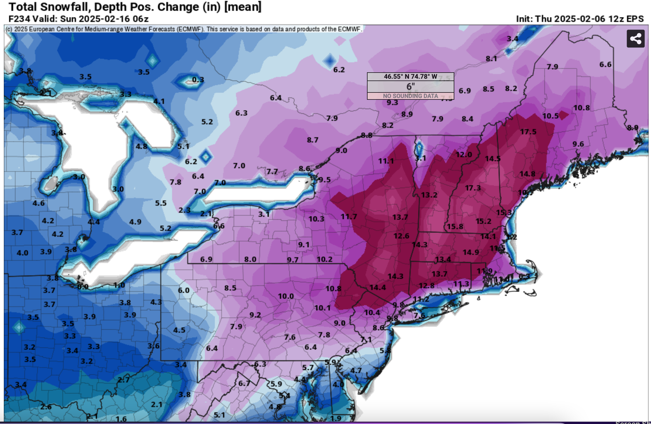
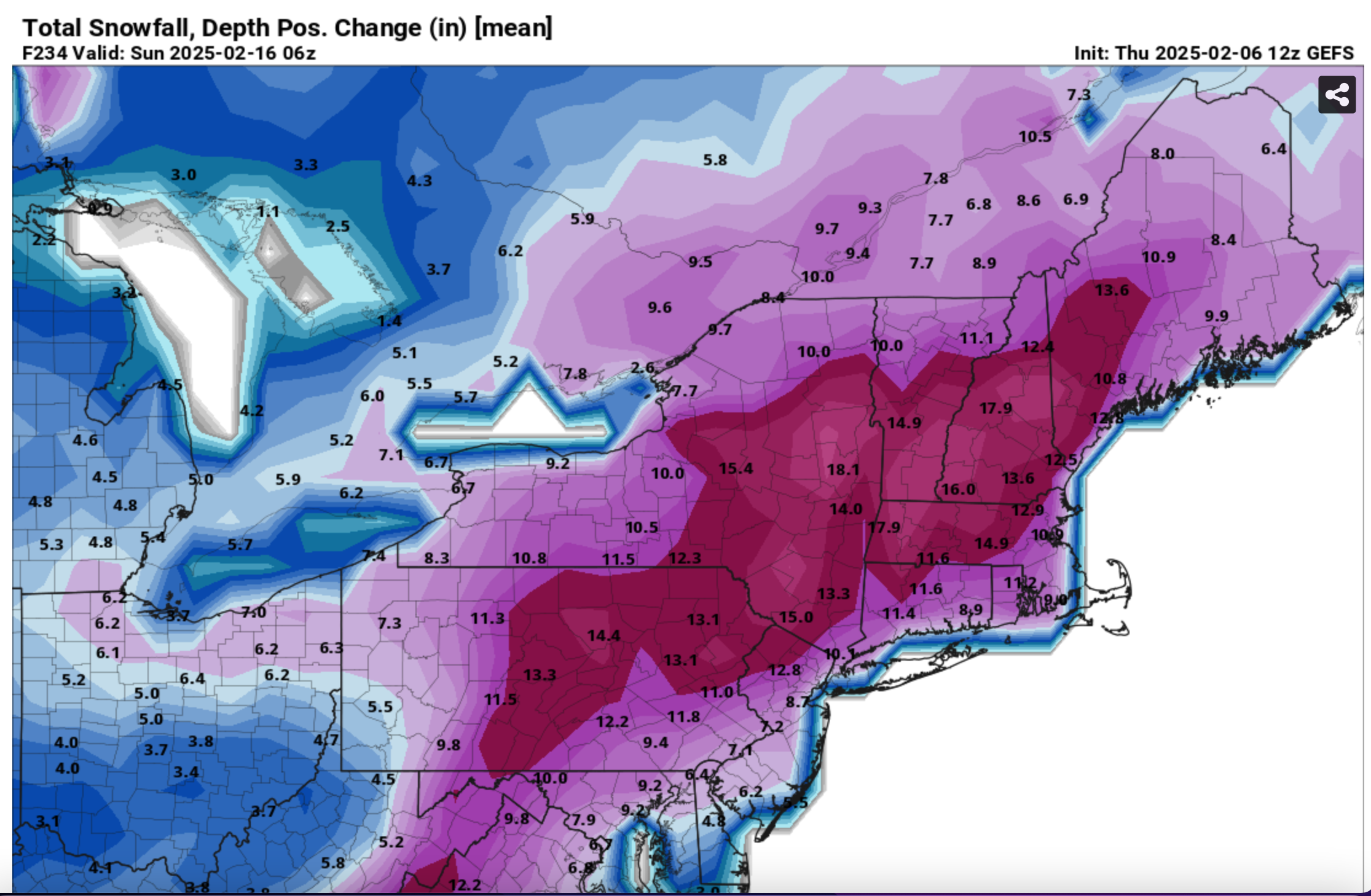
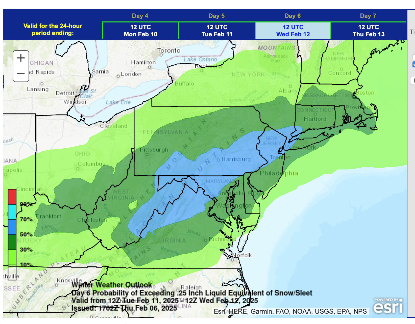
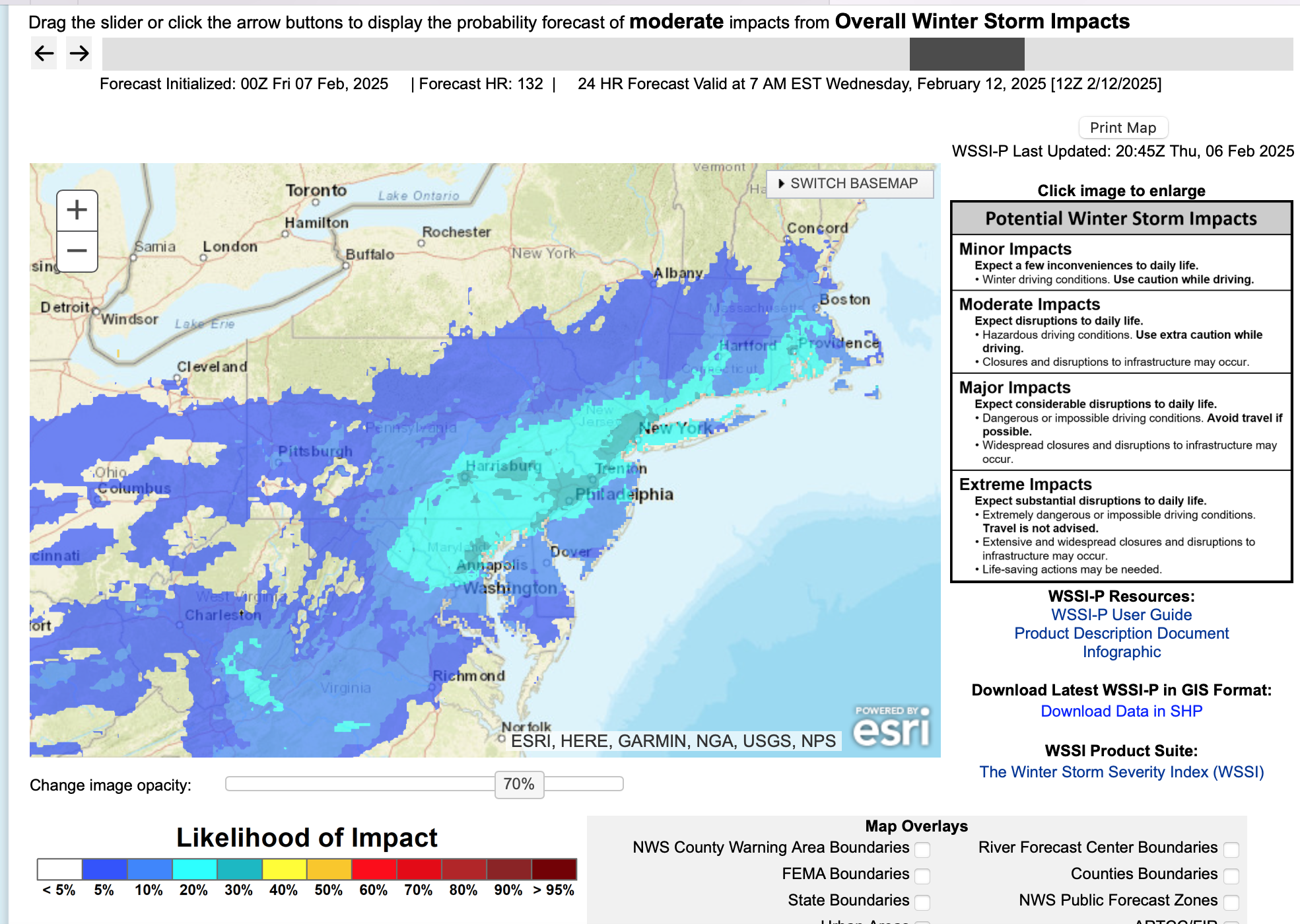
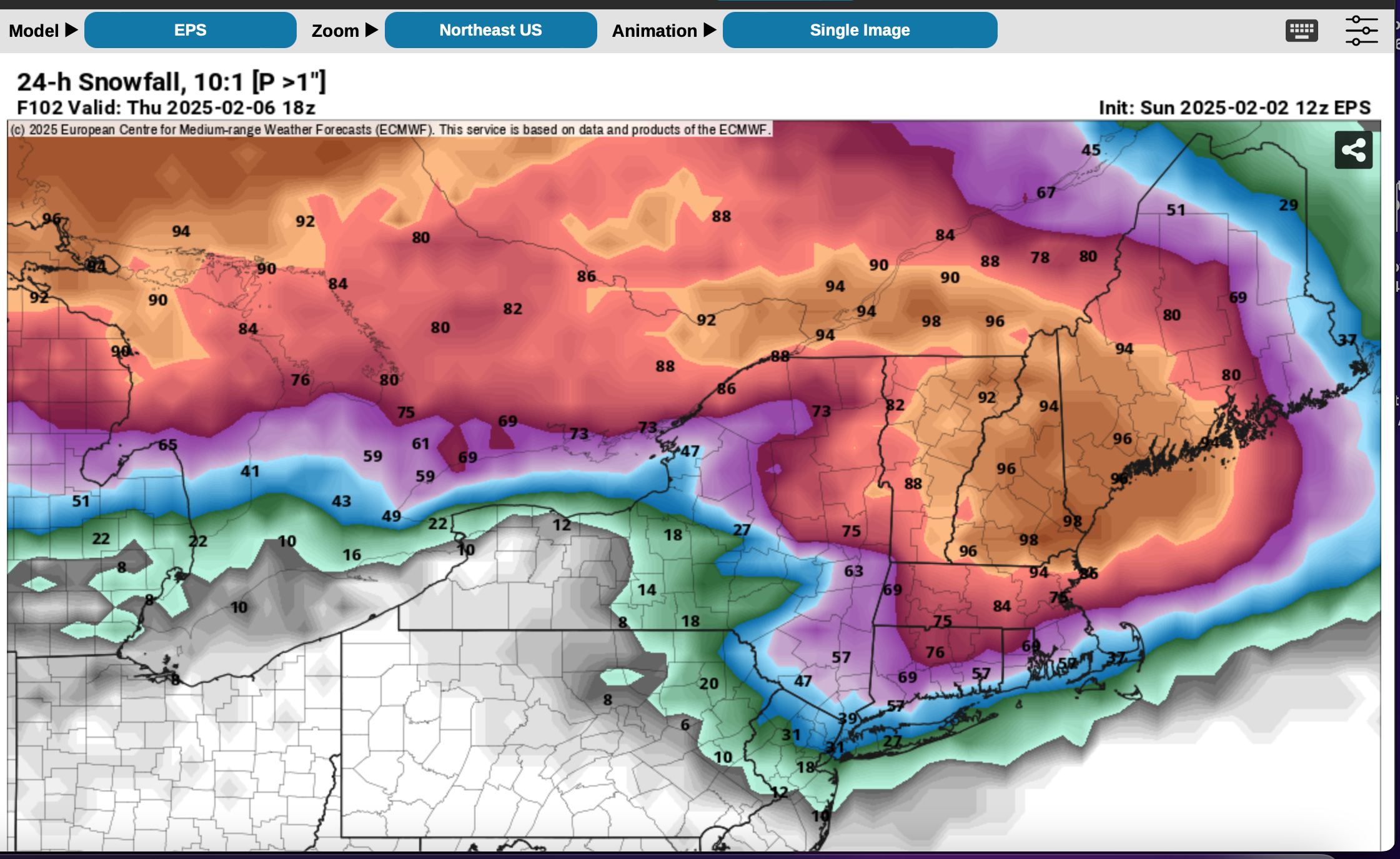
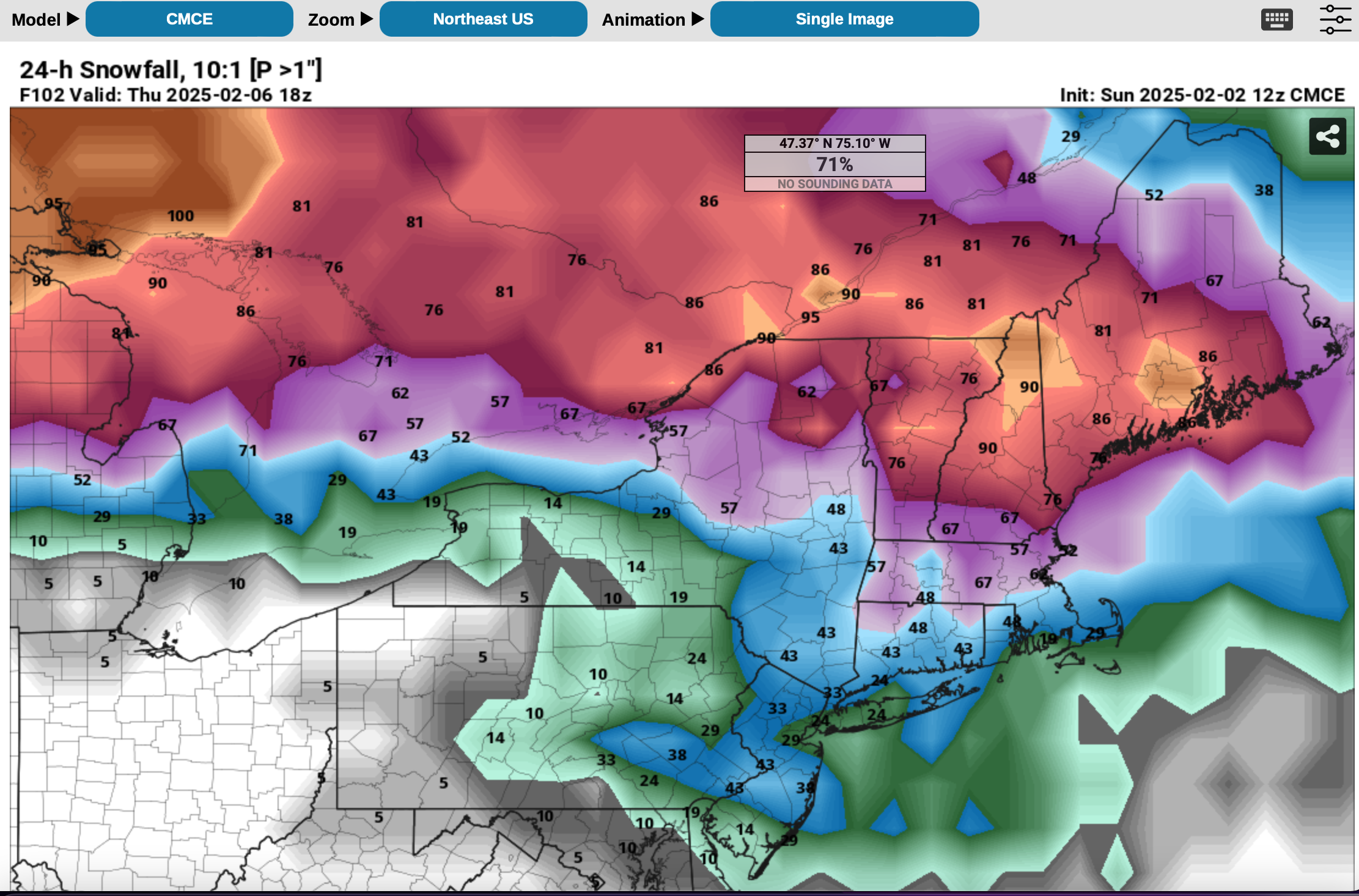
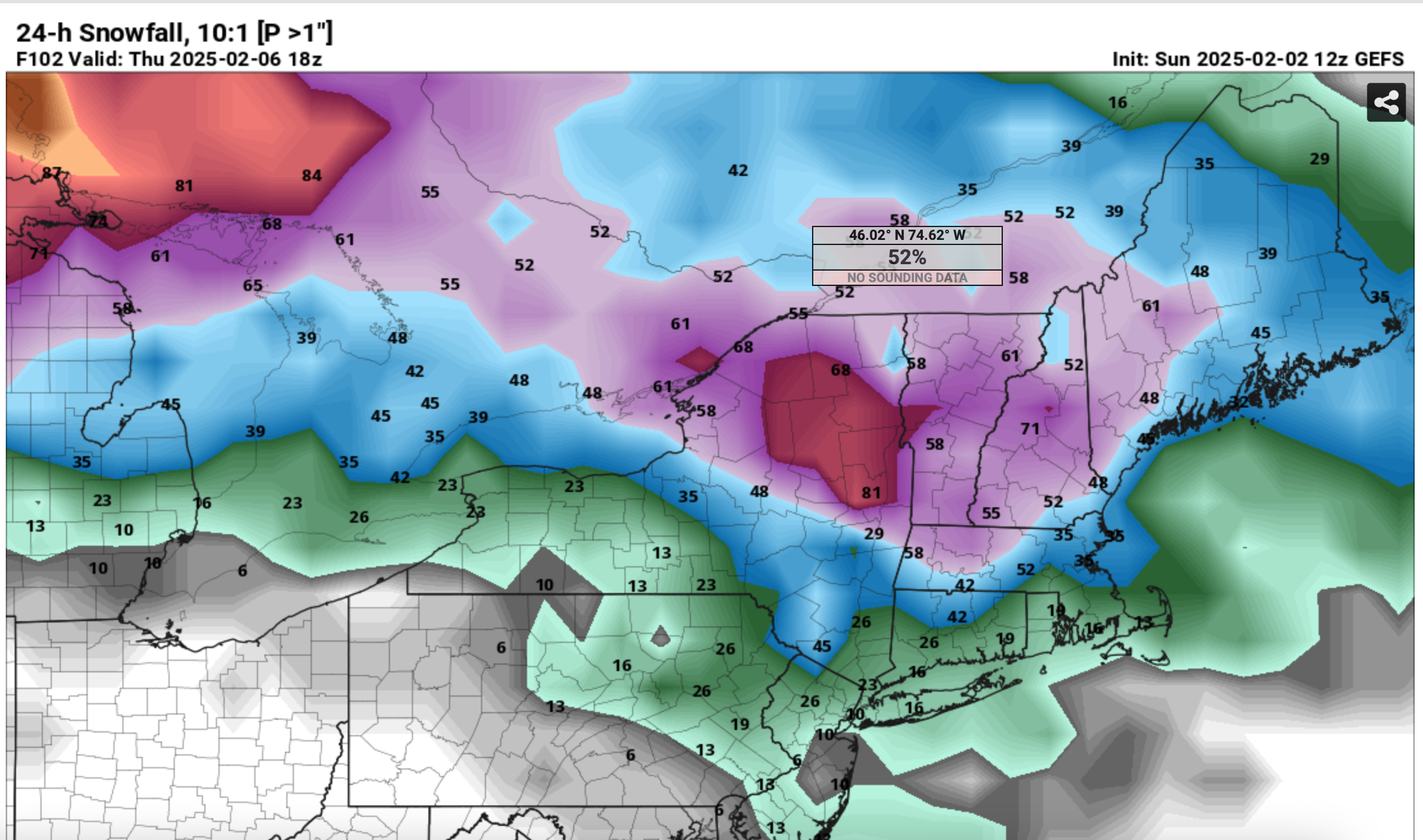
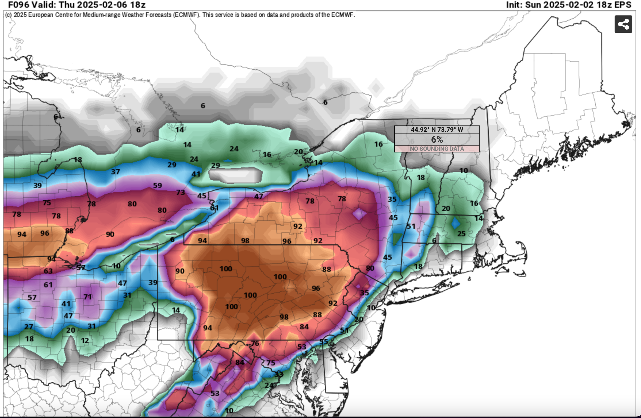
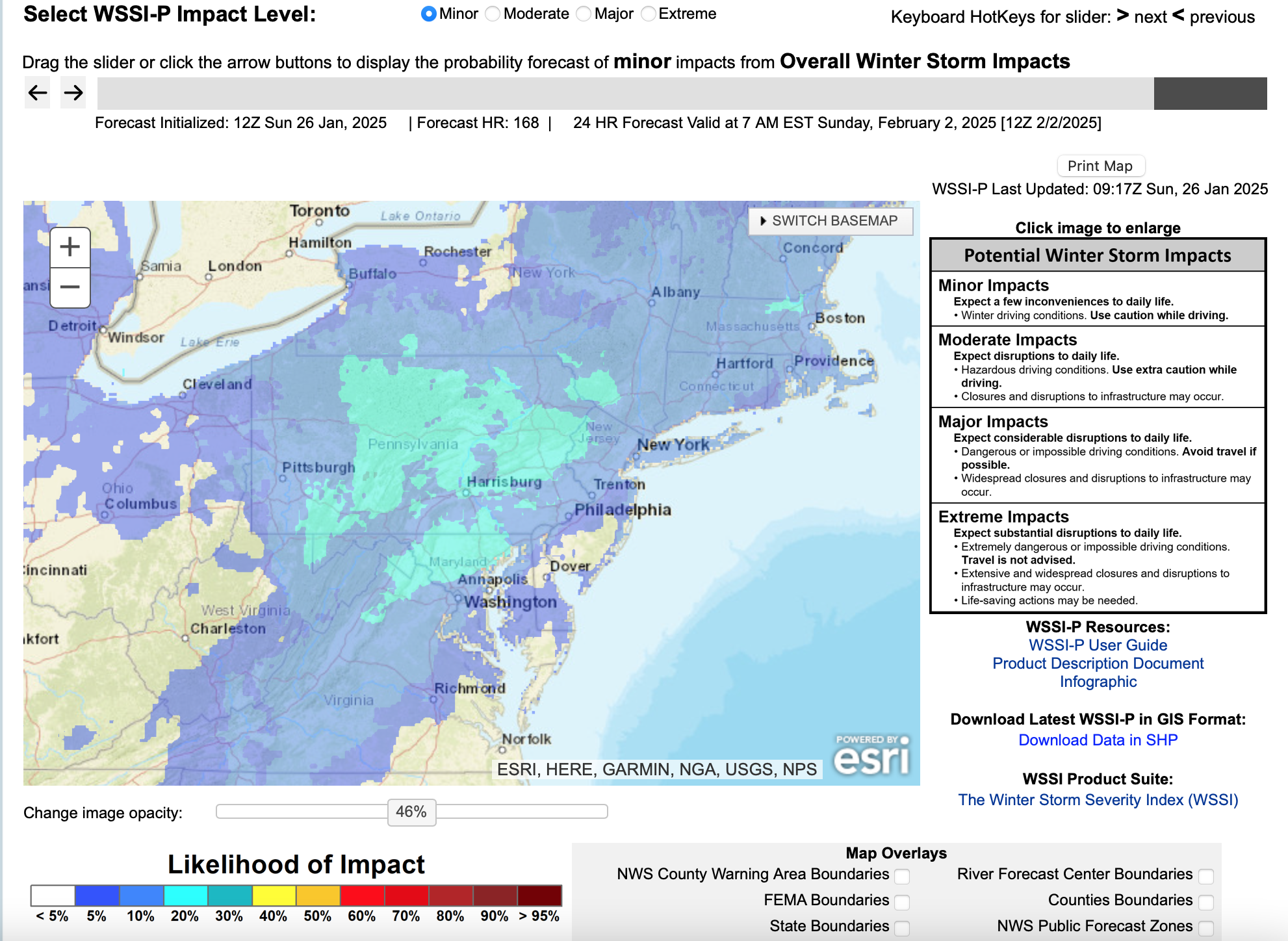
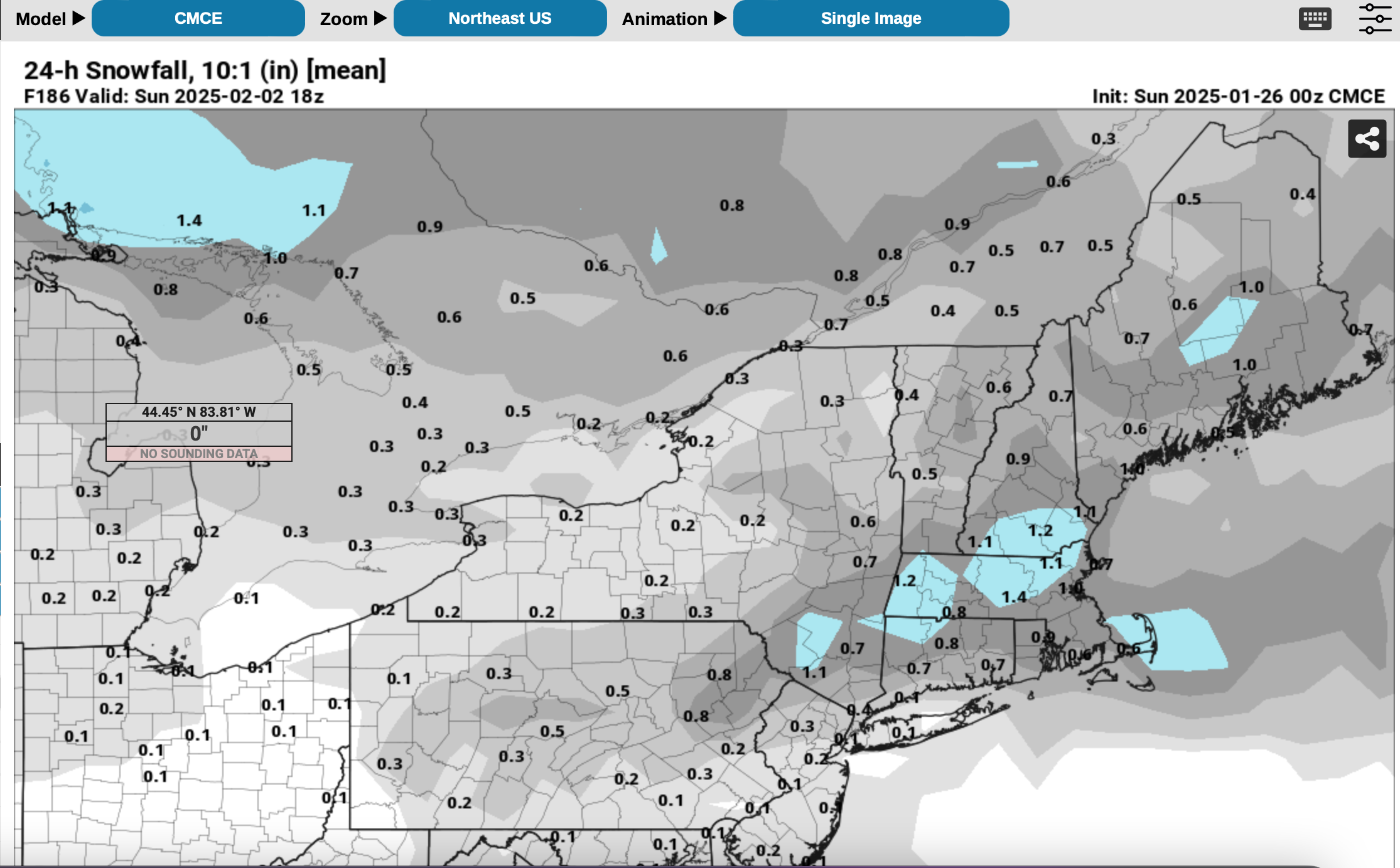
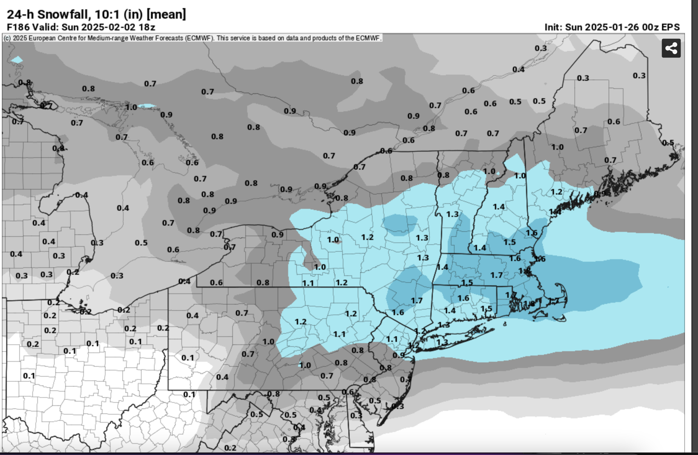
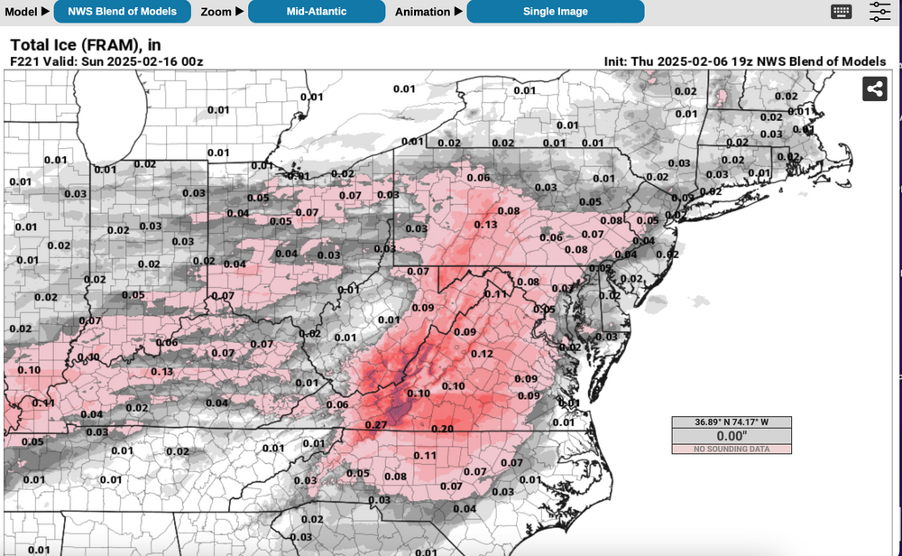
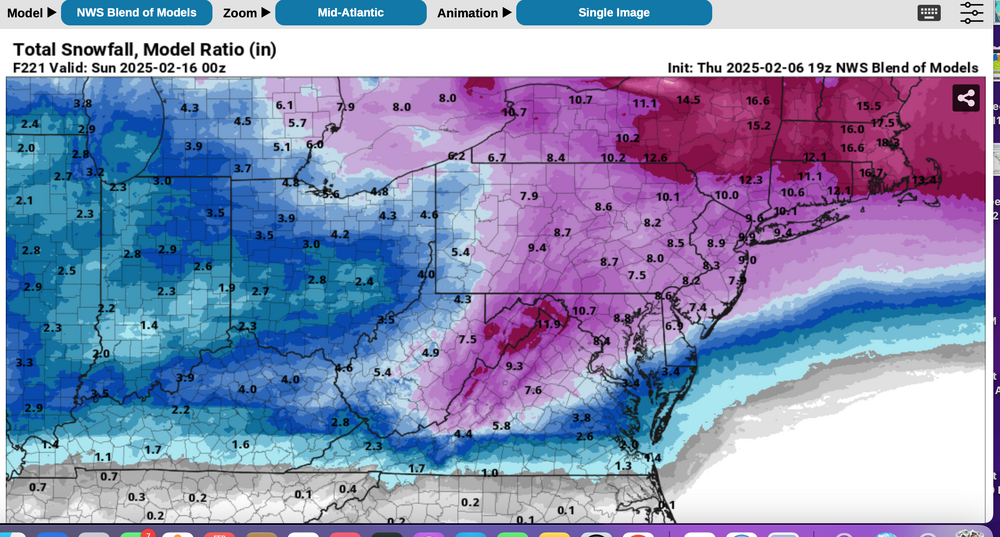
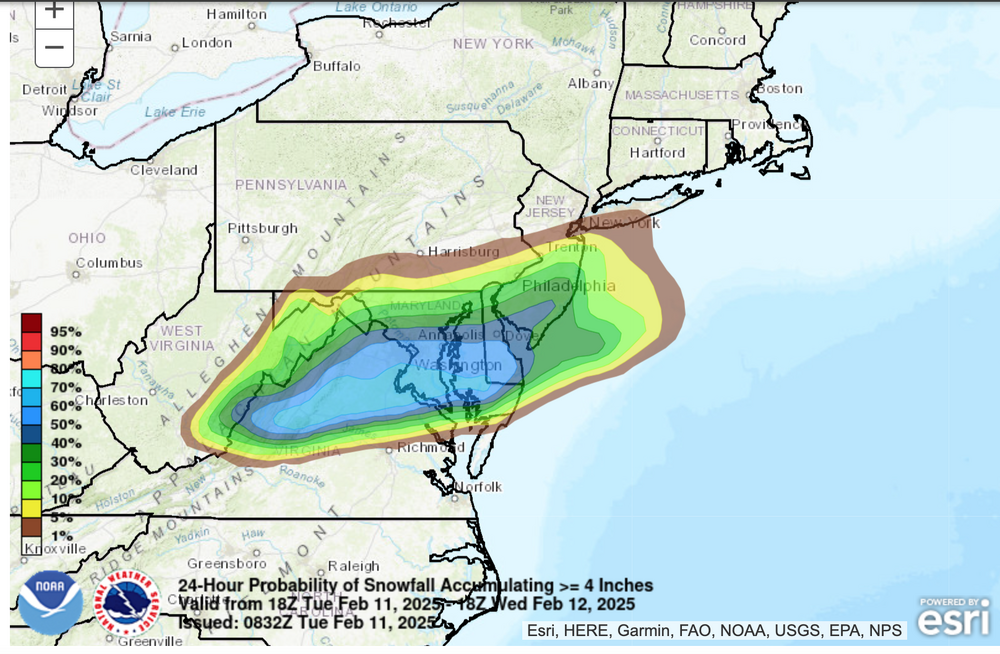
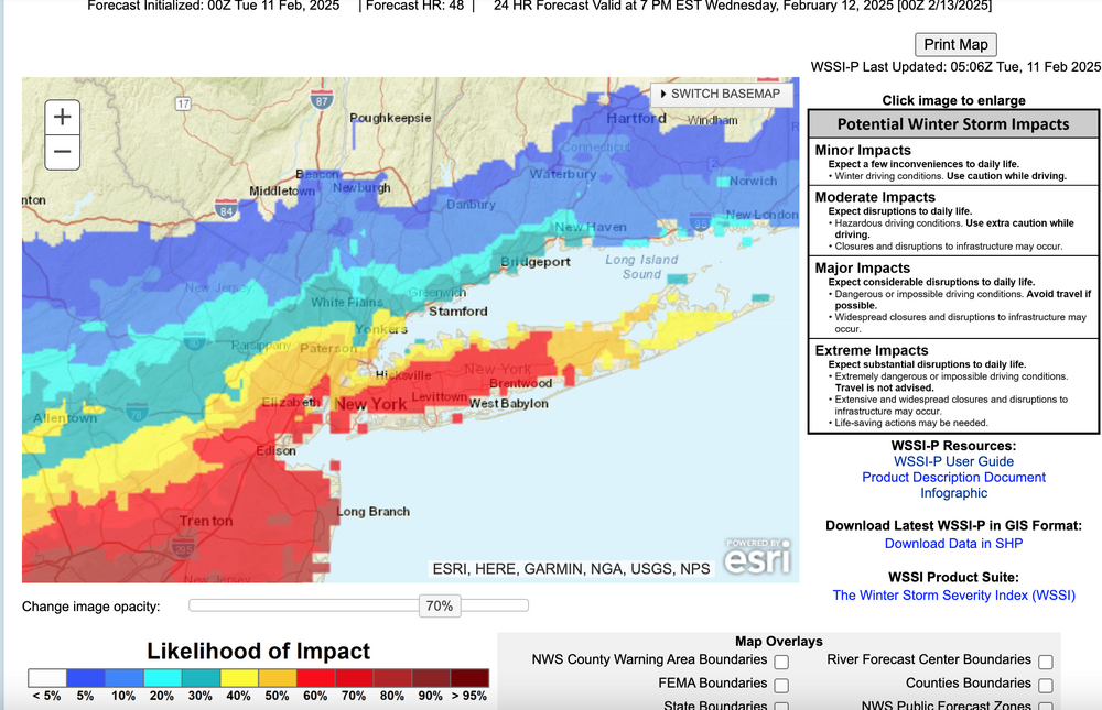
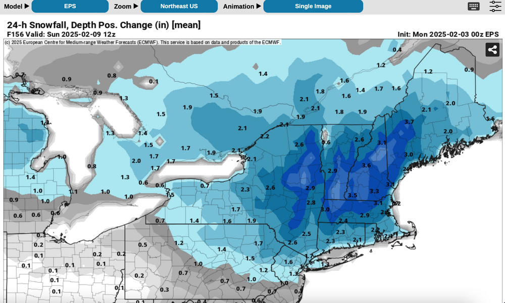
 Best chance for a total of 6+" inland with NYC-LI-coasts? Ensembles are added. All graphics should self identify. Ensemble snowfall is the more conservative positive snow depth change and prefer to minimize overhyping despite a decent looking pattern. It and the NWS Blend of Models snowfall does include some snow from this weekend, but the bulk is with in the Feb 11-15 period. One thing I dont like about the BOM is that it has averaged snowfall across all of LI instead of adjusted toward the ensembles. The BOM may be right if two of these decent events are all snow for LI. Included also is the Blend of Models somewhat realistic expectation of a little freezing rain, probably better than the EPS. The WPC 6-7 outlooks are attached and finally the conservative WSSI-P which implies an I95 modest snowstorm (low probs moderate in this example for D6) Generally cold high pressure should extend from the Canadian Rockies across southern Canada in this period with an average 150KT 200MB jet core persistently centered near Boston. That places the NYC subforum on the edge of the RRQ of the upper level jet, rather close to the core, so that in my opinion, some southward suppression might occur in the surface pattern during this time frame or the NAEFS (multi ensemble inclusive of the CMCE-GEFS) might change as the models change over the next week. Ensemble guidance basically is producing 1+" of qpf for our area in this time frame. All yours! 713P/6


-
And so begin our semi-annual February floods: The firehose is poised and aimed. The creeks and streams runneth over. Puddles gather on low lying areas. Dams are pumping out 2-3 generators. The Holston River in west Kingsport this past Friday (2/7) The Obed today 2/9 MRX:
-
Most of the snow tonight. Areas of light snow, flurries or possibly freezing drizzle may linger after sunrise Wednesday. NWS 08z/11 ensemble probs for 1 and 4" attached. At 734AM I added what I call the slippery factor--WSSI-P, run off 05z data... the red is 60% or greater chance of MINOR impacts overnight. I sort of like this product. Edited previously intended headline start time at 327P/11 At 410AM have extended the headline into the second event since this reduces thread bounce, AND, I think that "parts" of our NYC subforum including LI, NJ, PA will see an additional few tenths of an inch of snow today with ice pellet very minor amounts this evening, and of course the obligatory icing well inland overnight. Don't be surprised at a little drizzle-freezing drizzle for LI and the NJ coast today. The additional snow may not stick very well during the daylight hours as temps rise. Still suggest cleaning the snowboard AT MOST once every 6 hours and see what you get. I hope we get some decent rainfall overnight. Thank you for all your shares. I am considering starting the 19th-20th snow storm-event late this morning.
-
Discuss the possibilities of little more snow-sleet for NYC-LI. Please check back on the 7th for the review of the attached guidance, maybe used as a learning tool. Ensembles temporarily trended a little colder so that NYC CP-parts of LI may receive 1/2-1.5" of snow sleet to start before a change to rain. Most of the precipitation looks to occur 6PM Wed-Noon Thursday, starting as snow or sleet then changing to rain by sunrise Thursday NYC-LI, but freezing rain-sleet interior, northwest of I95. That freezing rain sleet may linger into midday over parts of nw NJ/interior se NYS, interior CT and the Poconos where mixing warmer air to the surface should be minimal until sometime Thursday night (baggy flow Thursday morning). Time of transition from snow-sleet to rain-ice will determine amounts of snow/sleet. This event may impact (slow travel-transportation delays) during the Wednesday evening commute depending on the start time, and "should" leave at least delays and/or widespread cancellations for the interior early Thursday. Total melted qpf should range between 0.3-0.8".. with the GEFS the least. QPF factors into the resultant amount of the various wintry elements. Ensembles already included are recently colder prob of >1" snowfall (includes sleet) from the EPS, CMCE, GEFS. the EPS 06z/6 2m temps, the ensemble chance of >0.10 freezing rain qpf from both the 12z and 18z cycles. Those probs have been consistently very high for the past several days---BUT caution on interpreting .10 qpf as .10 glaze. It could be significantly less depending on temp/rates of fall, drop size. I also added the EPS raw qpf interpreted as freezing rain. Ensembles show a primary low moving up into the eastern Great Lakes-upstate NY by dawn Thursday with a warm frontal wave moving northeast off the NJ coast, possibly maintaining itself through forenoon Thursday passing e of LI, then merging with the primary low in eastern Canada Thursday night and returning subfreezing temps to the area by daybreak Friday. The amount of subfreezing cold that returns in the wake of the departing eastern Canada low on Friday, will help determine what happens here next weekend (Feb 8-9). If somehow the primary near the eastern Great Lakes is dominant and there is no warm frontal wave of low pressure coming up the NJ coast, then snow-sleet amounts would be less. Final 757P/2. 702 PM Tue 2/4: headline delayed the start time about 12 hours to midnight Wed night. Bulk of the wintry mix probably occurs in a 6 hour window roughly 4AM-10AM. All of the NYC subforum and surrounding areas near and inland from I95 are covered by a winter wx advisory issued at 330PM Tuesday. Several hours of slippery conditions in snow ice are also expected in NYC and Long Island near dawn-sunrise Thursday before a change to rain. The delay was caused by the narrow snow streak in se PA-MD-DE Wednesday morning not advancing northeastward until Wednesday night.


-
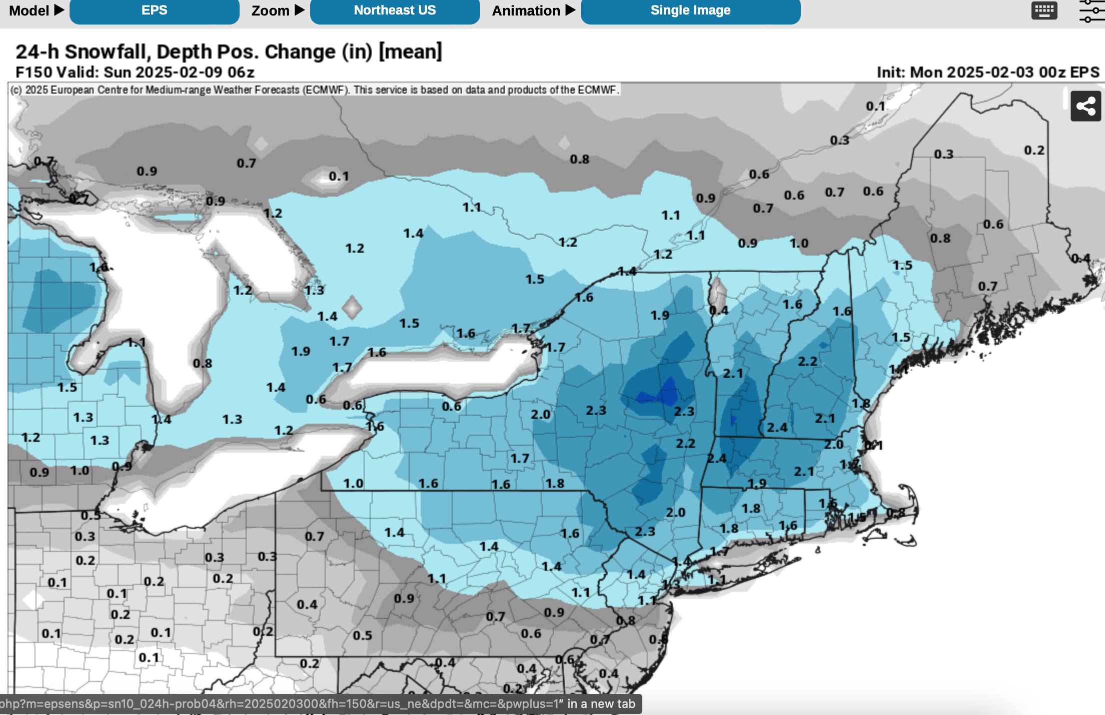
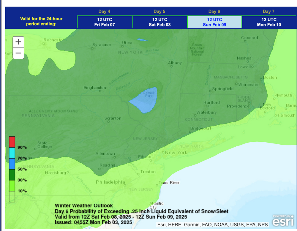
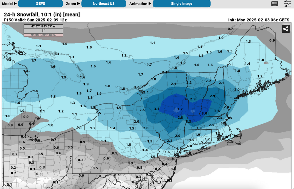
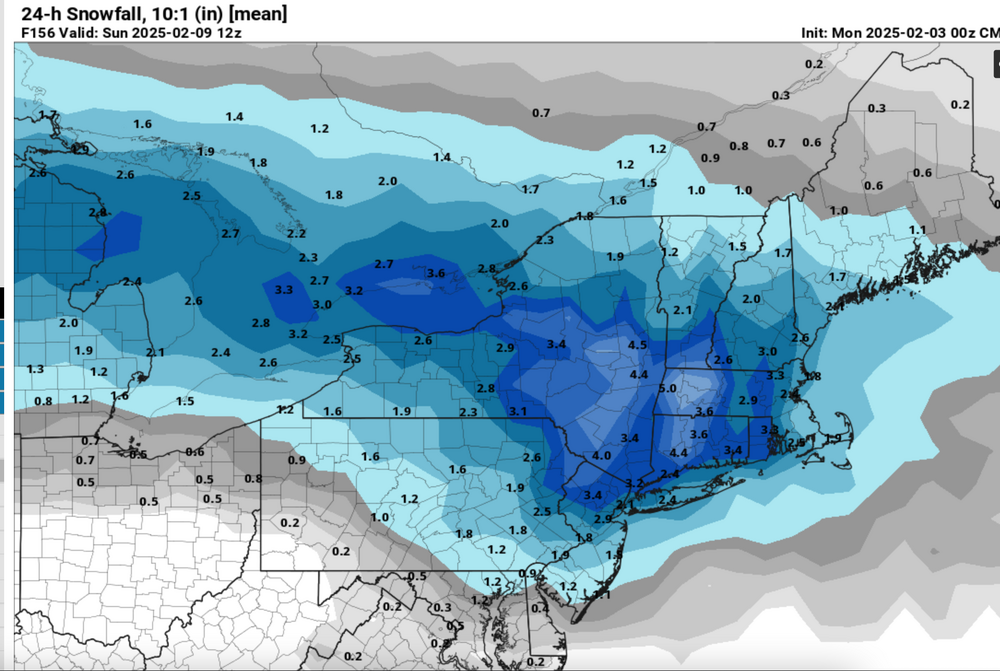
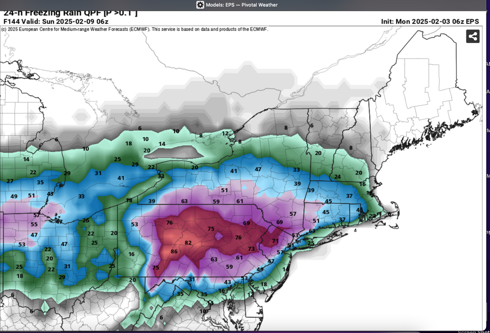
This coming weekend Feb 8-9 NORTHEAST USA near and west of I95 through the 184 corridor: Another mixed wintry event with delays and cancellations likely, especially later Saturday into Sunday morning. Timing might be in error as we're 5 days in advance. QPF is ensembled similarly to the 2/5-6 event, somewhere between 1/4-3/4". For now the attached ensembles favor I84 corridor down to the interior of I95 with more risk of rain and melting NYC-LI. The presented ensembles can be in significant max latitude (n/s) axis error 5-6 days in advance of the occurrence. It is a trackable event, in what looks like a train of events for February...some of which can veer off and disappoint but we're at least in the wintry mix game. Ensembles include the midnight 2/3 WPC D6 outlook confidence of >1/4" melted water equivalent snow sleet. (blue is greater than 50%, pretty good for D6. Other ensembles 24 hr snowfall (10 to 1 ratio), an ensemble that only shows positive snow depth change, and an ensemble probability of >0.10 qpf that is ice. This usually shrinks a bit as we draw closer to T0. 752A Mon 2/3/25

-
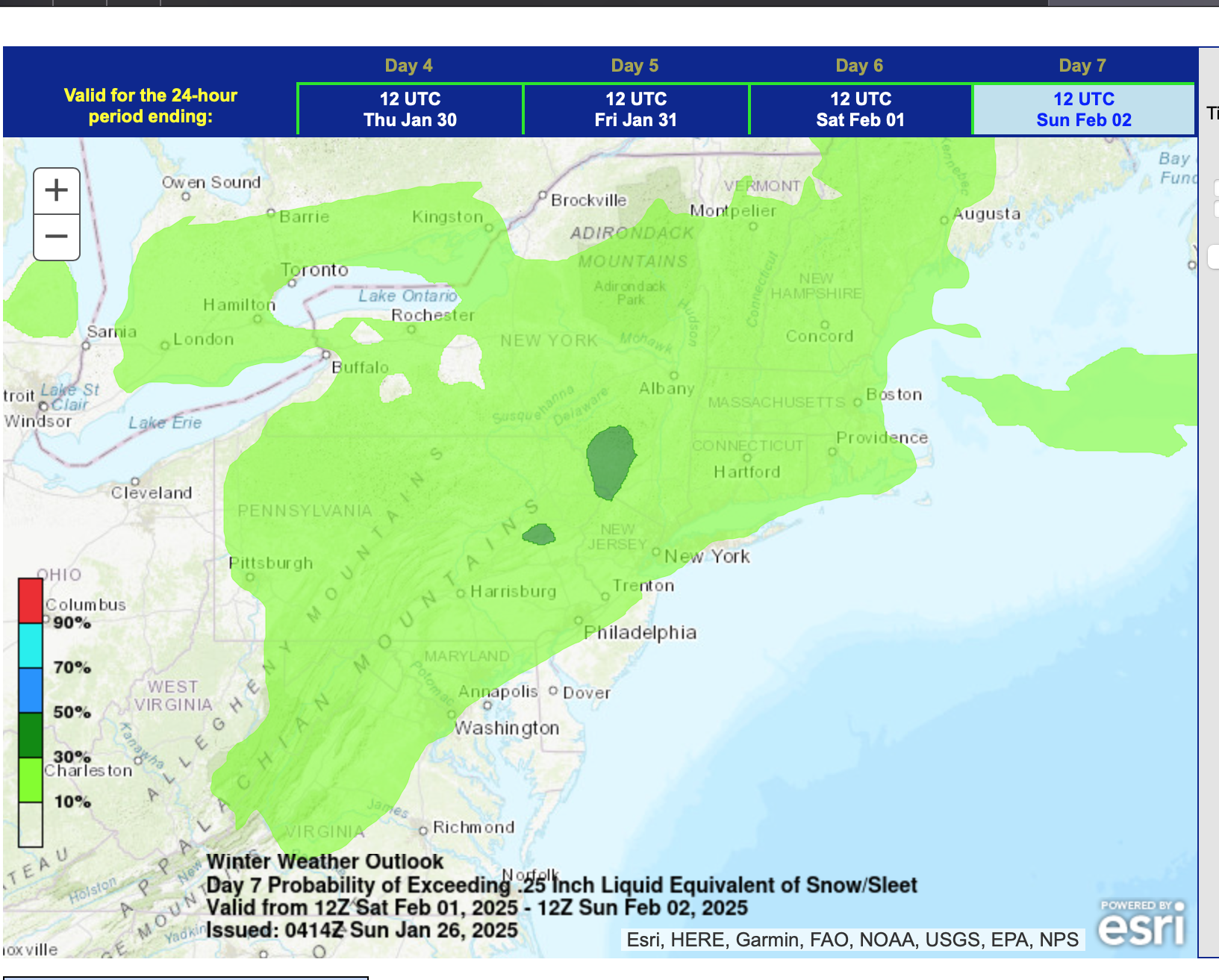
While most events are shaky on snowfall for LI due to thermal profiles, there should be a pool of subfreezing air covering the interior northeast during this event, available for making a messy winter storm, even down into NYC (NOT a KU). The remnants of this mornings CA 5H closed low will weaken as it heads eastward into the confluence zone over the mid and North Atlantic states this coming weekend. The cold boundary layer airmass that arrives Thursday the 30th after passage of an Alberta clipper off the Maine coast, should be available to interact with the Gulf moisture and lift generated moisture caused by the thickness overrunning ahead of the weakening upper low. Modeling is implying a secondary CFP Friday evening that will allow that BL cold in NYS-New England to be nearby. Precipitation type will be problematic due to the thermal profiles but the attached ensemble guidance suggests that this system is of trackable interest for our NYC subforum -both for travel into the interior where impact will be greater, and maybe witnessing some snow accumulation in NYC-though melting is anticipated on LI at times. Can our NYC 24-25 winter snowfall increase an inch or 2" next weekend (corrected my prior CP snowfall error). Ensembles should be self explanatory. I did add the EPS probability of >0.10 freezing rain Headline change below at 730AM Wed 1/29 for failed 7 day lead time on wintry accums NYC-LI. Discussion-OBS Jan 31-Feb 2 rain, potential minor interior impact mixed wintry events, mainly Fri Jan 31, Sun afternoon-eve Feb 2. Failed 7 day lead time LI winter impact. Events accelerated 18 hours and warmer-further north than modeling posted below in this thread indicated. Wrap up hat happened will post Monday Feb 3. P5 shows the NAEFS speed change. Self rated C-performance (see p 15 results against the ensembles posted here). Back end snow event entire subforum salvaged a terrible start. Max axis was significantly further north than ensembled. We had the Fri morning ice delays e PA/NJ/se NYS (24 hrs earlier than anticipated in this thread, but nothing else til the Sunday evening climatologically normal 1-3" snow event.


-
Modeling for the past several days suggests one or possibly two hazard events for a large portions of the NYC subforum, maybe excluding e LI? Headline has a large 4 day period for possibilities and cant be sure of anything except that precipitation will occur. Fast flow-thread the needle timing in the climatologically coldest time of the year with cold air nearby to draw into whatever low pressure systems approach. Hopefully this will not be 30+ pages of less than normal snowfall in CP. Daily CP norms (averaged out) are 0.3"/day. Am suggesting CP has a chance to stick 1-2" sometime in this period as modeling proposes 1/4-3/4" qpf in this time frame with temps at times below freezing. Ensemble temps tend to favor coldest temps in this thread periodJan 21-22. Most favored area for snow and ice continues as usual inland from I95, especially the I84 corridor (our nw-ne suburbs). Not looking like a major storm as of this 1/11 starter thread but annoying minor to possibly moderate impact 1-6" amounts of snow and a period of icing, especially interior just west of I95 through the I84 corridor Monday-Tuesday the 20th-21st. Another shot of reinforcing wind driven cold should follow around the 22nd? ICE: added EPS ice QPF here with several 12z/00z cycles of the EPS are offering glaze in the interior even near NYC which subdues the EPS expected snowfall. Ignore the NC ice which occurred earlier today.... and the qpf amounts need to are shaved by maybe 70% for reasonable glaze thickness. Am aware its fast flow and the lack of blocking could result in a failed thread but so far there is chatter and thought it good to pull the chatter off the January thread into one more focused thread. More snow opportunities Jan 25th onward as already suggested in the Jan thread. Added ensemble more conservative snow depth change for back checks on 1/22 to see how much this thread failed. We have to remember that the max snow axis error on multi ensemble agreed max qpf and snowfall can be in error by maybe 200 miles at Day 10. Graphics cleaned up at 735A/11. Updated thread title 1/16 349PM. Discussion-OBS minor-mdt mainly 1-7" slippery impact 7-14 hr snowstorm mainly btwn Noon Sun 1/19-4AM Mon Jan 20. Heaviest axis near or just inland I95. New thread for next unknown snow amount event with a large range from fringe 1" to at least moderate 1/22-early 1/24 begins about 5PM. Headline update at 504AM Friday: Discussion-OBS slippery plowable moderate to high impact snowstorm with many delays near I95 and inland btwn 10AM Sun 1/19-4AM Mon Jan 20. R/S line uncertain near and east of I95 - parts of LI may be limited snowfall of around 1"?
-
Well, we are just twelve weeks out from December, so I thought I would start a spec thread... I actually like these ideas in the article below: https://www.severe-weather.eu/long-range-2/winter-2024-2025-first-snowfall-predictions-united-states-canada-europe-fa/ I tend to think that our best shots at winter will be late November to late December, and then it gets warm and maybe stays warm. That said, as others have noted in the main discussion thread for fall, the strength of this La Nina is important. The IO is important. The PDO is important. The MJO is very important. PDO -> The September Cansips has the PDO staying solidly negative for the winter, and not really even coming up for air at that. MJO -> This will tend to favor warm phases as phase 8 will be cooler than normal and that limits convection there. IO -> Off the coast of Eastern Africa, there is warm water depicted. That would favor phases 1-2 of the MJO. It also favors warmer than normal water over the Maritime Continent which favors 4-6. 500 Heights over NA -> November a ridge is shown to be out West. It transitions eastward as December progresses, and then parks itself over eastern NA for Jan and Feb - monster SER of sorts. Maybe by April it relents. The NAO might be negative for the first 1/3 of winter before returning to a net positive state. It would not surprise me to see the pattern relax by April, and we see chances for snow in early April (especially the mountains). SSTs -> The La Nina on Cansips appears to fade significantly by February. By next summer, we might be seeing Nino conditions for the western 3/4 of the Pacific. We have talked about gradient. @Typhoon Tiphas mentioned gradient many times(I think I have the correct poster). That means the delta (difference) between the La Nina and the waters around it matters. The steeper that gradient, the more of a stimulus we get. El Nino was kind of a washed out gradient last winter, and we got washed out results on the EC. From the recent climate.gov ENSO blog, "Said more simply, it’s not just how much warmer or colder than average that part of the tropical Pacific is that jumbles up the tropical atmosphere, it’s the difference in warming or cooling compared the rest of the Pacific. And that’s where the relative ONI comes in! So where do things stand? The regular ONI for May-July was +0.2°C. But the relative ONI was already down to -0.4°C. That means there could be a scenario later this year where the ONI is not yet below -0.5°C, but the relative ONI already is, and the atmosphere might start reflecting La Niña-like impacts. Doesn’t that seem like a pain to communicate? " To me, since the Pacific basin is warmer than normal, La Nina might well have a threshold warmer than what we saw maybe 30 years ago. That means that what we see as a weak La Nina might actually be a bit stronger than we think. So, the weak La Nina forecast below might well be a bit stronger given that La Ninas might have increasingly warmer SSTs. Overall Forecast: I do think we see some crazy cold air masses at some point. I do think the Mountain West does really, really well in terms of snow and cold. In fact, the higher elevations there are already getting snow. Their winter has already started above 8,000'!!! I do think that middle and western portions of our forum will see a colder and snowier winter. But beware, if this truly turns out to be a weak La Nina....all bets(and I mean all bets) are off the table. Weak La Nina's in E TN can often be bitterly cold. So, instead of doing a monthly J-F forecast, I am going to simply put out a general forecast. One, well-placed cold shot during Jan-Feb could really skew things. During 2017-18 we had a crazy cold shot that straddled late December to January. It didn't snow much but was crazy cold. We were below freezing at TRI for seven straight days! The monthly climate data doesn't really show that cold shot as it straddled the end of one month and the beginning of another. That winter was also a weak La Nina. I am liking that analog year 2017-2018. If we had any precip in that pattern, we would have been buried. As it was, it simply froze things solid. December was -0.8F . Jan was -4.5F. Feb was +9.4 F. March was -2.1F. April was -4.1 F. Maybe we had a strat split late that winter??? I am going to go ahead and add these. And I am far, far deeper into this than intended...Sorry, this is kind of a "stream of thought" post, and maybe not as scientific as it should be. I also want to add 16-17 into the mix at it was a first year La Nina and should be weighted equally or more to 17-18. But here is why I am far less confident this winter. See the 94-95 moderate Nino listed in the graphic at the very bottom of this post. This past winter reminded me of that type of winter - blah and not a lot of chances. Now, what came after 94-95? The winter that shall not be named, because I just won't invoke a winter that is a benchmark winter of my lifetime, and it was true winter. It was a weak La Nina following a moderate El Nino. It is also a winter that maybe doesn't fit the current warm basin look of the Pac which is why I haven't used it. That said, it might deserve some weight though I haven't given it any. Just beware. So, for now, I like the 16-17, 17-18 blend of weak La Nina winters. December looks chilly. Jan is a tossup, but leans warm. Feb looks warm. I did break down the 16-17 winter by month as well as 17-18. I also provided a blend of the two which I tend to like better, and is probably pretty close to my thinking. In addition, the 16-17/17-18 analog blends might be of better use as they are recent analogs, and not almost 30 years old. Plus, those two analogs came from a weak El Nino which I think is a better fit. Notice that the March blend is not overly warm on the EC. I do think maybe some late season chances exist north of I-40, especially in E TN and the southern Apps. ***The following would be my best guess for winter temps.*** Refer to the article at the very top of the page for snowfall anomalies. Those looked about right. Reference for ENSO graphic list: https://ggweather.com/enso/oni.htm And if you made it this far, thank you for reading this! I intended to make a short post, but ended up just saying, "Screw it," and wrote a long post. LOL. I normally don't like long seasonal forecasts, and really, those long posts end up being very wrong much of the time. I really think seasonal forecasting often involves false correlations, and I am sure my post is guilty of some of that. In other words, sometimes my seasonal forecasts might "appear" to be correct, but often it is just blind luck that they even got close. In other words it is like saying TN is going to win a ballgame because of Nico, but really they win because of great defensive line play. They won, but not really my line of thinking. So, have some fun with this, but don't take it as the gospel. This is just for fun. Feel free to post your winter ideas in this thread. And this thread is not meant to be the December 2024 winter thread. That will have its own thread. This is merely a speculation thread, and won't be rolled into a winter thread. If this verifies, we could see some cold college football playoff games during December....
- 29 replies
-
- 11
-

-

-
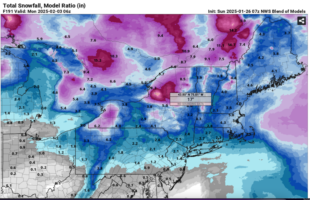
Added the 1/18 CPC FEBRUARY outlook and the new CPC week 3-4 issued 1/26. Both posted here on 1/26 748PM. While the anomalies are warmer than normal the first two weeks of February, it might not mean absurdly warm preventing snow in NYC. The warmer than normal anomalies seem to be more centered up in Canada, modifying the potential for true arctic intrusions down here. Guidance suggests the potential for several east coast storms In February and the possibility of snows from Asheville to Boston - I95 westward. That may be climo combined with the El Nino pattern of potentially above normal precip southern USA and up the east coast to NYC. So, can the NYC CP Feb snow total exceed our January total? Temperatures may chill down a bit in mid February? Will add on here Friday evening the 26th with the new 1/26 CPC guidance. May also add Don's stats if he has any for this pattern for Feb. Thank you all. And now the CPC Jan 31 update for Feb. Looks a little higher prob of not so much qpf, and chilled New England a bit. On March 2 attached the Feb verification. Looks like our local take verified OK with the mid month chilling, and twice the Jan paltry snow total at CP. and the CPC trend to below normal qpf also worked out with east coast events trailing off the coast south of our area.
-
Different than the refresher powdery event of Sat Feb 17, and this past Tuesdays Feb 13 wetter snowstorm, it still has possibilities for adding to our winter snow totals with modeled "potential" for half a foot or more for the I84 corridor inclusive of the Poconos-extreme nw NJ interior sections se NYS-CT. Possibilities even exist for an inch or four down to I95 and NYC though for now, odds are less. This could be one warmer more rainy event the 22nd and then a following rapidly intensifying coastal storm Fri-Sat the 23rd-24th. As generally usual higher terrain-inland best chance for snow. A strong short wave in the eastern Pacific this weekend will move through the southwest USA early this coming week and probably be ingested into a series of northern stream Canadian short eaves that dive southeast into Midwest and form a sharp amplifying trough over the northeast USA by next weekend. Details tbd. This probably will be of NYC subforum interest for some of us the next few days as winter potential refuses to go away. Added 10 to 1 SLR, 24 hour 00z/17 global ensembles and the NWS 04z/17 very low chance 3+" snow D6-7, to look back upon when whatever transpires. Title tightening up and downgrade update at 537AM/20. Verification attached for a failed event- useless thread. Numerous traces of sleet -snow-rain mix I84 into NNJ 3P/22-9A/23 but modeled short waves remained separate with one tracking across se Canada and the other actually trailed and dropped down through the Carolines. Was over early per the poster comments.
-
Attached are two 24 hour EPS graphics from the 12z/10 cycle that are significant for D6-7. The CMCE and GEFS are much less of snow risk for the northeast USA, so far. This thread is started because of the several consecutive cycles, although variable placement, EPS persistent snow threat for the I84 or I95 corridor, and it's possible snowfall outcome for NYC. Also is attached the 19z/10n Blend of Models from the NWS as a sketchy idea for I95. Reminders: The CMCE and GEFS are weak with the snow risk. Tags may be adjusted in a few days as it becomes clear whether our NYC subforum only gets a short period of snow/flurries in the wake of a strong windy cold frontal passage with single number-teens wind chill by Wednesday morning, or we realize a nice coastal wave of low pressure that produces hazardous wintry weather for the majority of the NYC subforum, then followed by a shot of the wind driven cold. This system is not as clear cut at D6-7 as previous storm threads in Dec-Jan, so uncertainty exists. [Typo on headline Thread. updated 854PM/10]
-
The downward slide into winter begins. Post your Obs/Discussions here.
-
Well, PTC has been designated off the Florida coast. Models have really honed in on the NC coast from Cape Fear to Hatteras as a landfall threat. Models are also indicating this could become fully tropical before landfall, and possibly strengthen to a high-end TS. As a short notice event, folks should probably prepare for the equivalent of a hurricane landfall. The forecast track also could be nudged west, as some models are showing. Areas from the Triangle-east need to pay attention. This is likely to produce higher impacts than Idalia for the state.
- 31 replies
-
- 3
-
-
- tropical storm
- nc
- (and 5 more)
-
 There is likely going to be some warmth during mid-month - and maybe extreme. So, I am not starting this thread w/ any sugar coating. That said, models are sniffing out a cold shot to start this month which wasn't seen on some modeling even 24 hours ago. In life we go one day at a time. Let us not borrow the troubles of tomorrow until they arrive. 12z Yesterday and 12z today of the GEFS.
 -
 Since we do have a variety of forum posters in areas that will see snow/sleet/ZR - at least initially and on the backend, plus there is a flood threat, along with some potential advisory-level winds and possibly record breaking cold, decided to go ahead and make an obs thread. Currently misty and mostly virga and 36 with dp 32 here in NW Philly.
 -
Day one of met fall, highs in the 70s, humidity fell through the day. Hard to beat after the heat, humidity and rain that ended met summer.
- 167 replies
-
- 4
-
-
- frost
- cold front
- (and 4 more)
-
February discussion for all things winter in the Tennessee Valley Sub-forum. When we have a likely event 2-3 days out we can create an individual thread for said storm. It helps for record keeping purposes as a lot us like to look back on old threads to learn, etc. Hope everyone is doing well.
-
January discussion for all things winter in the Tennessee Valley Sub-forum. When we have a likely event 2-3 days out we can create an individual thread for said storm. It helps for record keeping purposes as a lot us like to look back on old threads to learn, etc. Merry Christmas to all as well, I hope everyone has a great holiday.
-
454AM Wednesday Jan 12: title and tags adjusted to drop Saturday, focus late Sunday-Monday morning for what appears to be an 18 hour storm of snow-rain-snow. Heaviest snow tends to be modeled west of the I-95 corridor but ensembles still warrant continued concern for the axis of heavy snow including I95. At this point far too uncertain but where it snows for 12 hours, widespread 6+" seems likely. Also a 6 hour period of potential 50 kt inflow gusts is possible for the coasts Sunday morning and if it occurs with the dawn Monday high tide, would result in coastal flooding, magnitude unknown. This does not appear to be a long duration storm (24 hours+) but it should be intense for a few hours Sunday night or Monday morning. Again track uncertain, and sensitive to the intensity of the surface low. There still is opportunity that this will track too close to our area for much snow but there are several days to adjust the track and resultant precipitation type. It does appear there will be a general inch to 1.5 inches of qpf with this system, maybe thunder too. A big storm with large scale impacts entire east coast-Appalachians. The only reason I didn't highly stronger wording for impact, is that this will occur later Sunday and the following Martin Luther King Jr. Holiday. --- At this 6-7 day lead time 8PM Sunday Jan 9 issuance, options are fairly wide open. For now, a light or moderate event 'seems' likely but absolutely not a lock, nor is a heavy event excluded. This event still could be demolished to zero by what happens off New England on the 14th, or what follows between the 19th-22nd. However there already has been discussion the past several days for the coming weekend. Ending 12z/9 the past 6 cycles of the ECMWF op, the last 4 cycles of the CMC GGEM [LI 3 cycles, I84-4 cycles] have some sort of snow event, especially I84. Maybe the GFS via it's 18z/9 cycle is shifting snow emphasis on the 16th for our area instead of bombing off the coast on the 14th? Having reviewed ensembles: 12z/9 EPS/GEFS/NAEFS all have some sort of frozen event is coming to the northeast USA, along and north of I80 including LI. Have added the broad coverage low chance WPC D7 issued at 17z/9, the EPS 24 hour qpf ending 12z/17 and the 12z/EC 850 MB low (GEFS so far has nothing, still favoring the 14th but not as far south and west as previous). NAEFS products for 00z/17 are added including previous 24 hr qpf, 00z sfc temp in C, and the sfc pattern. There will be quite a few model changes-conflicts and this could end up having been a wasted effort... but it seems worthy of further scrutiny as our next possible significant snow or ice event for at least a portion of the NYC subforum.
-
Modeling is favoring the development of some sort of extensive precipitation event along the east coast, with either the first or second of two short waves carving a pretty deep, albeit temporary 500MB trough in the eastern USA between next Friday and Monday. At least until Tuesday the 18th when the results of the 16th-17th are in, lets hold off on single model solution hype. Three graphics added, two from the 08z/16 WPC issuance. Low prob 3+" of snow, and the third was the CPC D8-14 hazard graphic, it paints a small chance of heavy snow just north of I-80 again (just like this 16th-17th event). It also ,not shown here,has a high chance of very cold air here 22nd-28th. 7AM/18 Update: I've updated the thread title-no guarantees our NYC subforum will share in what is coming to the Demarva-Carolinas but it seems models are gravitating to a decent snowstorm for a portion of the mid Atlantic and possibly through southern NYS-southern New England. 718A/21: Changed thread title to add part one was about 150mi too far southeast (slightly less average error for a D5 forecast than NHC on tropical systems). Withdrew wind from the tag. Otherwise the overall intent of the thread remains the same.
-
While uncertainty exists on the target for a rain to hazardous brief commuter significant snow event, a thread has been started to take the load off January. Thursday morning I84-NYC-PHL: Looks like 1-3" of snow in a 6 hour period centered on sunrise, with potential significant impact to morning travel due to temps falling to freezing during snowfall. There is model uncertainty on amounts. Snow could fall for an hour at 1/2-1". I84 itself seems to be on the northern fringe where snowfall could be less than 1". Amounts also depend on how fast the preceding predawn rain showers change to snow but I am confident of a snow event, just not confident who gets the biggest impact. Tomorrow morning we should have a much better idea of travel impact. I would add that climo on something like this probably favors an inch or less NYC CP, but I do think there is going to be a narrow lane of more than 1" per multiple model indications. NWS ensemble risk of greater than 1" is less than 30%, so that is the reasoning for calling this Potential, in the headline. 656PM: adjusted Title to OBS-NOWCAST. Added freezing rain and rain to the tags. First batch of mixed precip should arrive ne PA, extreme nw NJ and se NYS around 1-2A as snow freezing rain-rain, but the primary batch is slated to occur between 5AM and Noon as snow north and west of NYC til NYC-Li and NJ I95 changes to snow around 7-830A. It ends from northwest to southeast, first in nw NJ by 11A and then NYC by 1P and further southeast during mid afternoon. Amounts near I84 of a dusting to possibly 2" with a general 1.5-4" in the core of the event from near NYC/LI-down I95 in NJ. It may briefly snow 1/2mi moderate for an hour or so. Still a little uncertain where the 4 inches are...probably NJ/LI.
- 280 replies
-
- 4
-
-
-
- snow
- freezing rain
- (and 1 more)
-
Cyclic modeling of the EC/GGEM and ensemble portion of the GFS since this weekend has been developing a fast moving late developing coastal low, resulting in a period of precipitation occurring mainly between midnight and 6PM Friday. Tracking and therefore precipitation type are uncertain but recent ensembles were offering at least 2" of snow to portions of our area, the EPS furthest west and the GEFS/GEPS a bit further east. The GFS op model has been generally offshore. If the low develops further north or further east, very little snow will occur here. Right now 850MB Low development looks too far north for a moderate event but probably worthy of monitoring and trying to figure it out. Based on the model performance for the 1/3/21 grazer snow, we may not know much til we see the NAM consistently give us 1/4" qpf in frozen form with more than 2" of event Total Positive Snow Depth as shown on the Tropical Tidbits web site. 12z/3 500MB ensemble plots below serve as a baseline to witness future modeling departures, GEFS top and EPS next. IF this approaching short wave ends up weaker or further north, it will be difficult to receive meaningful snow here. At 321PM added the 16z/3 WPC D4-5 probs of 1/4" frozen W.E. (lower 2 graphics) which bridges Friday morning 12z/7. The darker green is greater than 30% chance.
-
637AM Sunday: : headline updated to Major near blizzard and added power outages. Major near blizzard Nor'easter coming. I would not plan on driving anywhere on Monday in northern NJ, ne PA, se NYS and ditto CT Monday afternoon-night, MA Monday night. NYC my guess is a foot, possibly more before mixed Monday night. Otherwise, amounts between 1-2 feet from I78 northward with lesser 8-18 inches CT and MA where rain/sleet invades later Monday night. Isolated 30" possible nw NJ, or ne PA into the Catskills by the time this storm ends early Wednesday.. Drifts 3-4 feet. Power outages possible Monday afternoon and night from northern NJ northeastward to CT and Boston from a combination of heavy wetter (heart attack for the hear tcondition vulnerable) snow and northeast wind gusts of 40-55 MPH. Snow starts central NJ around 3 PM, northern NJ-ne PA 6-10P, CT around dawn Monday. Worst of the storm NJ/PA sunrise Monday-midnight Monday night, CT Monday afternoon-night. Coastal flooding may be major near the midnight Monday high tide cycle? Follow NWS. ---- 615AM Saturday: Imperfect probably messy big snowstorm is coming, imperfect in that modeling the past 24 hours is drifting north and suggesting a dry slot late Monday will allow enough warming for sleet (rain LI) to I80 including all of I95 Monday night so that the stratiform burst of 1-2"/hr Heavy snow during Monday, especially afternoon, becomes bands of snow in the interior late Monday night-Tuesday, some areas probably recovering Tuesday with several hours of no precip. So, my own single forecaster point of failure but use of ensembles could be too pessimistic about the sleet/rain intrusion. For NYC... I'll start with 6" with possibly as much 1/2" late 31. Hope that its mostly snow after 00z/2 but even if, snow ratios may be down to 7 or 8 to 1?? I dont' want to cap NYC since am uncertain about dry slot. Sleet/rain/freezing rain may be getting involved Philly to Toms River during Monday morning. There may be a period of near blizzard conditions on LI centered Monday afternoon? BUT, I don't want to call it a blizzard for fear of easily missing criteria. The point of this paragraph, is that I think Monday, especially afternoon should be the worst period of travel and if models continue this, in future cycles through Sunday morning, then I think it would be a recommended no travel for that 6-12 hour period to limit accidents and allow plows to maintain passable-less slippery conditions for first responders. Snow may be wet on LI/Monmouth-northern Ocean Counties in NJ if 6" at 32-33F, we would have power outages... still too early to be sure. CT I84... continue to notice some multimodeled lesser snowfall there, so while I think a big snow there, cautioning myself. Coastal flooding: see NWS statements/flood watches already posted and no change from yesterday with the late Monday evening high tide cycle most favored for flooding (within 2 hours either side of the time of high tide) Graphics are the 00z/30 EPS as a base amount, the 00z/30 EC IR prediction for 06z/Tue showing the dry slot penetration, and the NWS 09z/30 prob for 6" or more of snow by 12z Tues. That's the reasoning basis for this update.
- 2,426 replies
-
- 4
-
-
-
- heavy snow
- ice pellets
- (and 3 more)
-
Overall assessment as modeling monitored through 6AM Monday. Complex intermittent snow to sleet to freezing rain scenario with potential for 0.1"-0.5" measurable snow sleet NYC-LI while parts of the I84 corridor receive spotty 1 to possibly 2" snowfall. It should begin in NYC/NJ/ne PA/se NYS between 11A-2P and CT maybe between 2-5P. While treated surfaces in metro NYC should be mostly wet, caution is advised everywhere. The National Weather Service has advisories posted for the I84 corridor. I think this could be more of a problem further south in NJ. Also: the worst of this for some of our area could occur near sunrise Tuesday if it clears after midnight and everything refreezes into a frosty icy mess, especially driveways, sidewalks-steps. No thread expected (at least not yet) for late Tuesday-early Wednesday where w wintry hazardous mess is expected again-at least for the high terrain of I84 (strong mid level Frontogenesis). A few graphics to give an idea of what should occur. 631A/27
-
Many models have a little snow or ice for our area next Wednesday the 8th, possibly ending as rain? WPC Friday afternoons forecast has a half inch+ of qpf for our area next Wednesday and a 30-49% chance of 3+" of snow or 1/4 inch combined sleet/snow. Click the graphics. That's not too bad for a day5-6 forecast. I may have overreached on PROBABLE hazardous???? I do think there should be a little ice, at a minimum over the I84 high terrain. The rest of the area much more uncertain. We should be close to the right rear quad of an upper level jet core centered near Nova Scotia (130 knots 200-300MB) next Wednesday (see EPS 18z Wednesday 300MB), this behind the strong negative tilt short wave departure of Monday. A weakening 500MB short wave from the upper Midwest Wednesday morning crosses into northern New England by Thursday morning. The 850 Low is north of our area. Snow thicknesses are marginal especially south of I84, so that snow amounts this far in advance are VERY uncertain and likely to be less than 3" rather than more. Some sort of light to possibly moderate ice-snow event should occur in parts of our interior Wednesday Dec 8. One consideration is the qpf being less than currently advertised which would reduce amounts. This thread is posted to focus anyone's interest into the discussion. LI-coastal NJ--- primary modeling may eventually favor your area but for now, I think the primary ensemble considerations for a 6 to 18 hour period of hazardous wintry weather next Wednesday is to the northwest of I95. TAGS and Thread title may change this weekend or early next week. 717PM/3 Dec 2021 6AM Wednesday the 8th: converted this thread to OBS-Nowcast. No other change.