Search the Community
Showing results for tags 'Snow'.
-
The 12z CFS run apparently gives us snow. Even though it doesn't really show it on the precip type maps, it does show it on the snow depth maps. October 13, 2025 officially marks the start of the 2025-26 Digital Snow Thread! Coastal on 11/08: Clipper on 11/10
-
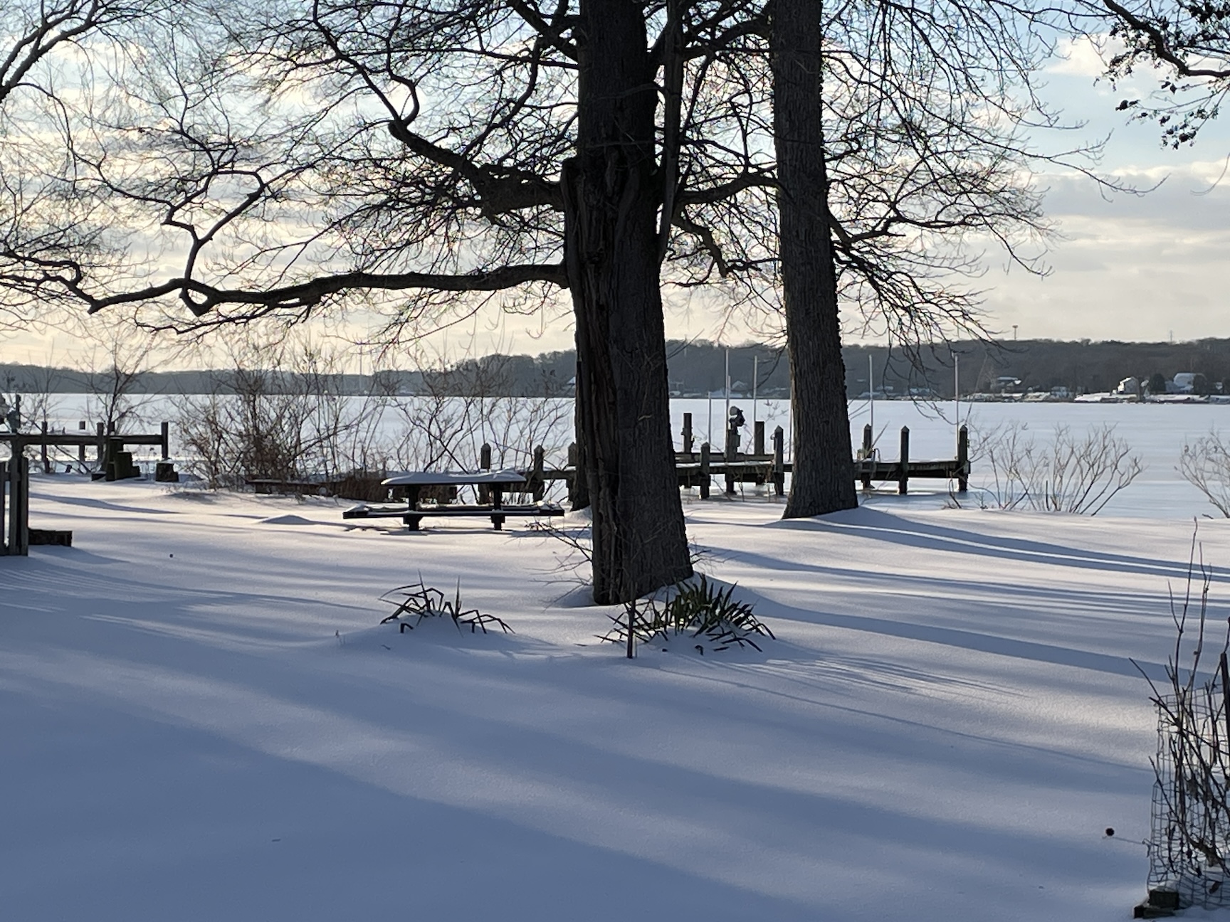
A place to share photos of the late January snowpack, of hopefully more snows to come, and of our mid-Atlantic winter scenery in general! Photographers and non-photographers welcome. Beautiful art shots and sooty parking lot piles, it's all good. Here is a shot of the Bush River, covered in ice and snow.

- 46 replies
-
- 18
-

-

-
A place to discuss the short lead time/surprise snow that is not otherwise thread worthy.
-
Thought I would create a general obs thread for winter in case anyone sees some snow this AM and of course for the rest of the winter. @Knoxtron looks like some temps are between 34 and 36 down your way. Some radar returns down in. NE Alabama look snow-like: Wouldn't be surprised if you, or John, or one of our Cumberland county folks get a quick dusting.
-
January 23-25, 2026 Winter Storm thread. Things are heating up so we decided to go ahead and make a dedicated thread to this upcoming winter threat. Appreciate everyone’s input
-
Figured we may as well have a thread for this. All modeling except the Ukie and ICON have basically 2+ inches of snow from the Western side of the Plateau and points east. With several being more wide spread and much heavier. Extreme cold is also a story. We could have 20-1 or even higher ratios. The Euro has Saturday afternoon temps 30 to 35 degrees BN across the state. We could have snow falling with wind chills below 0, and if the GFS is to be believed, incredible snowfall totals, especially for NC border counties. The event is basically 3 days away from beginning. Let's reel something in!
- 782 replies
-
- 2
-
-
-
- extreme cold
- snow
- (and 1 more)
-
Post your Obs in this here thread. Let's do this!
-
May be the last snows for most of the Sub for 2025. All models are showing decent 2 day accumulations of 3 to 6in or more from IA into Central/S IL, Central/S IN through N KY and E/SE OH with wiggle room a plenty. Go
-
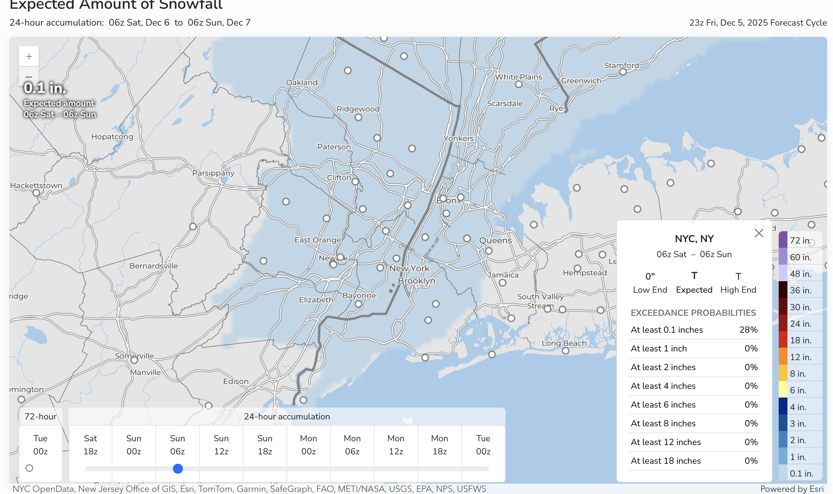
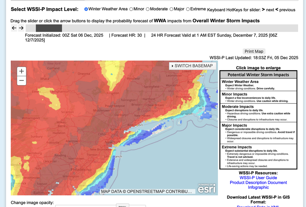
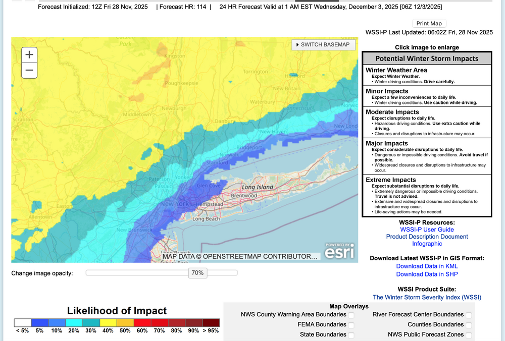
 OKX issued an SPS for tomorrow morning covering parts of the area and multiple models but not all, have spotty very light freezing-frozen precipitation in our area over night. mPing may be helpful in addition to monitoring radar developments, especially 4A-9A Sat. Questions are: will the expected low top precipitation be heavy enough to measure 0.01 NYC metro and will temps remain at or below 32F in CP overnight. Couldn't wait much longer to decide. Graphics below: WSSI-P for winter drivIng habits overnight... ie not even MINOR impact according to the criteria, and the probabilstic snow portal for NYC CP. So odds are against but am not waiting this out. Probably no measurable snow NYC but someone in the I95 corridor of NJ-NYC-CT is going to get a little wintry weather overnight... more than the flurries of earlier today. 658P/5
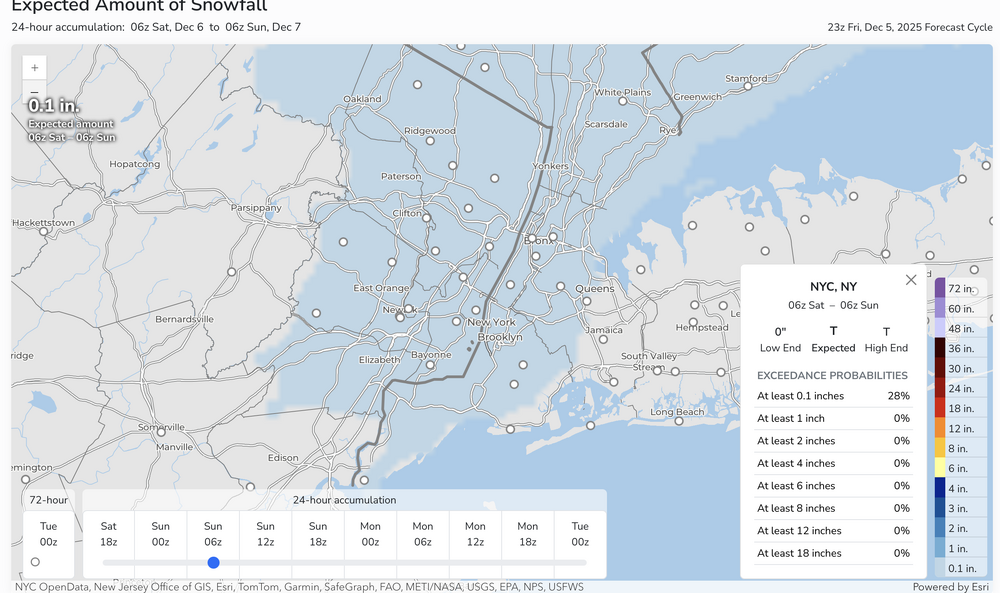
-
Based on ensemble guidance seen through 06z/28, a rapidly intensifying and fast moving coastal low will bring a variety of weather elements to the NYC subforum. Periods of moderate to heavy rain are expected coastal areas- preceded by a little snow-sleet near dawn Tuesday and to closeout the storm Tuesday evening, while a period of heavy snow-sleet seems likely for the interior, especially the I84 corridor. Gusty northerly winds to 45 MPH are possible for eastern Long Island in the early Wednesday morning departure. Due to the late development and rapid departure of the storm, the chance of coastal flooding is minimal. All ensembles including ECAI have significant precipitation. This may be Central Parks first measurable snow-sleet of the season, though temps at or just above freezing at sunrise Tuesday may preclude onset measurable in the city. Delays are anticipated over the interior hilly terrain with possible school closings or early dismissals along and north of I80, especially the I84 corridor from the Poconos across se NYS into CT. One attached graphic (WSSI-P) shows the potential for a minor impact event per the NWS inputs for the their 1AM Friday forecast.
-
The GFS joined the Euro with some potential snowy hi-jinks to welcome met spring. As was noted, virtually all decent March/April snows over the last 50 years featured a cooperative or at least non-hostile pacific and MJO in Phase 2/3. It looks like we may be hanging out in 2 around the time the snowfall is showing up on the models.
-
It's time for the 11th annual Mid-Atlantic snowfall contest! First, thanks to @Roger Smith for pointing out that last year's contest, which was billed as the 9th one, was actually the 10th, as Roger unearthed records of the first one, which occurred during the 2014-15 snow season, and was won by @nw baltimore wx. So he has been added below to the list of previous winners, including last year's winner @Kmlwx Second, those who participated last year will recollect the consensus that a Strong El Nino was going to end the Mid-Atlantic snow drought, but that did not happen. So, it appears that snow lovers in our region will have to put their faith in a Weak La Nina this snow season. That may not sound too promising, but perhaps the consensus will be wrong again. Also, I note that we are nearing a solar maximum, which just maybe will somehow, some way upset the apple cart and bring ample snowfall to the Mid-Atlantic. In any event, the focus of this contest is forecasting the total snow that will fall during the 2024-25 snow season at BWI International (BWI), Reagan National (DCA), Dulles International (IAD), and Richmond International Airport (RIC). In the event a tiebreaker is required (that happened 6 years ago), please choose one of the following two airports: Salisbury, MD (SBY) or Lynchburg, VA (LYH). Choose only one. Please note that you are forecasting the total snowfall for the entire snow season (NOT just Dec/Jan/Feb) to the nearest one-tenth of an inch. Generally, snow does not fall after early April at any of these airports, and so the contest is usually finalized by early to mid-April. The winner will be the entrant who has the lowest combined absolute value departure for all four airports. For example, if you forecast: BWI: 0.0" DCA: 0.0" IAD: 0.0" RIC: 10.0" And the actual seasonal totals turn out to be: BWI: 2.5" DCA: 2.5" IAD: 2.5" RIC: 2.5" Your absolute value departures would be: BWI: 2.5 DCA: 2.5 IAD: 2.5 RIC: 7.5 Thus, your total departure would be 15.0. Please use the following format when posting your forecast, in this order: BWI: DCA: IAD: RIC: Tiebreaker (SBY or LYH): The deadline for entries is Sunday, December 1, at 11:59pm. You are welcome to update your forecast at any time up to the deadline. However, please do not edit your original post -- either submit a new post or send me a private message. If there's any accumulating snow before the deadline, please include that in your forecast as well. I think the best approach is to submit your forecast in advance of the deadline and update if necessary, just in case you get tied up on December 1st, when the contest will lock -- no late entries will be accepted. The winner gets an E-trophy made of snow and an induction into the Hall of Fame with the previous winners: 2014-15: @nw baltimore wx@S@S@Shadowzone 2015-16: @Shadowzone@Stormpchadowzone 2016-17: @StormpcStormpchadowzone 2017-18: @olafminesaw@Storm @olafminesaw 2018-19: @olafminesaw (tiebreaker win against @Stormpc) @Stormpc 2019-20: @Prestige Worldwide 2020-21: @NorthArlington101 2021-22: @IUsedToHateCold 2022-23: @LittleVillageWx 2023-24: @Kmlwx Everyone is encouraged to play, including lurkers, new members, and people outside the region. Good luck everyone!
-
Thread started due to 3 successive cycles of the EPS/GEFS/CMCE showing 1+" in 24 hours and amounts increasing through the most recent 00z/14 cycle. Will this be relatively benign snowfall only raising our monthly total close to normal, or could it be our first 6+ Central Park event since late Jan 2022? Whatever happens, it looks like powder (presuming it snows an inch or more in CP), with some gusty north-northeast winds. Graphics: 00z/14 cycle WPC D7 and GEFS,CMCDE, EPS 24 hour (10 to 1 ratio) amounts with various ending times late Thu the 20th or early Friday the 21st. Reminder: These ensemble snowfall axis can be in error by over 100 miles on a D6-7 forecast so the modeling provided is not a lock where currently placed. 7PM 2/17/25: adjusted headline to narrow the timing goal post of what has become a much more uncertain event since initially proposed...even with the option of no snow. This despite a strong short wave passage Thursday evening. The GEFS still closes a low through PA while the EPS has weakened to an open - less ominous progressive short wave trough with no significant 850 MB onshore circulation. The 15z/17 SREF, 18z/17 NAM and 12z/17 JMA are the only models with any significant hope for snow as the globals have largely faded southeast since thread inception. The apparently lagged average BOM and 12z/17 WPC still maintain an opportunity for a period of light snow (1/2-4" nw to se on the BOM).
-
I figured it was time to start the next monthly winter thread. Let the speculation/discussion begin.
-
This thread should essentially close out the multi event thread, transferring event comments and serving to report snow/ice obs later today-tonight, rainfall totals sometime Sunday, followed by wind gust reports 50MPH or greater including damaging wind late Sunday afternoon-midday Monday. One graphic added is the ECMWF EPS max wind gust graphic 1PM Sunday-!PM Monday... highest gusts showing up on the ridges and mainly late Sunday afternoon-midday Monday. Sometimes this graphic can be too strong with wind gusts 5 to 10 MPH less than modeled... still even if its a little less, the strong wind is probably gong to impact some of us late Sunday-Monday morning. The hope for our I84 friends is that the east facing slopes of the hills above 1000 feet will see temps rise above freezing tomorrow morning to melt snow and ice off the branches (watch for falling frozen debris) or widespread power outages would develop, especially Catskills-Litchfield Hills and possibly the northern Poconos. As it stands, some power outages expected here and there and probably a good idea to shelter everything that is vulnerable and preventable from some damage. AI ECMWF 2m 6 hr temps have risen a bit cyclically through the 00z/15 cycle but still looks problematic whether it rises above freezing north of I94 Sunday. No matter, that region along and N of I84 should try to safely remove snow and ice early Sunday afternoon from travel ways, or it will probably freeze solid Sunday evening and remain through the work week.
-
Best chance for a total of 6+" inland with NYC-LI-coasts? Ensembles are added. All graphics should self identify. Ensemble snowfall is the more conservative positive snow depth change and prefer to minimize overhyping despite a decent looking pattern. It and the NWS Blend of Models snowfall does include some snow from this weekend, but the bulk is with in the Feb 11-15 period. One thing I dont like about the BOM is that it has averaged snowfall across all of LI instead of adjusted toward the ensembles. The BOM may be right if two of these decent events are all snow for LI. Included also is the Blend of Models somewhat realistic expectation of a little freezing rain, probably better than the EPS. The WPC 6-7 outlooks are attached and finally the conservative WSSI-P which implies an I95 modest snowstorm (low probs moderate in this example for D6) Generally cold high pressure should extend from the Canadian Rockies across southern Canada in this period with an average 150KT 200MB jet core persistently centered near Boston. That places the NYC subforum on the edge of the RRQ of the upper level jet, rather close to the core, so that in my opinion, some southward suppression might occur in the surface pattern during this time frame or the NAEFS (multi ensemble inclusive of the CMCE-GEFS) might change as the models change over the next week. Ensemble guidance basically is producing 1+" of qpf for our area in this time frame. All yours! 713P/6
-
Most of the snow tonight. Areas of light snow, flurries or possibly freezing drizzle may linger after sunrise Wednesday. NWS 08z/11 ensemble probs for 1 and 4" attached. At 734AM I added what I call the slippery factor--WSSI-P, run off 05z data... the red is 60% or greater chance of MINOR impacts overnight. I sort of like this product. Edited previously intended headline start time at 327P/11 At 410AM have extended the headline into the second event since this reduces thread bounce, AND, I think that "parts" of our NYC subforum including LI, NJ, PA will see an additional few tenths of an inch of snow today with ice pellet very minor amounts this evening, and of course the obligatory icing well inland overnight. Don't be surprised at a little drizzle-freezing drizzle for LI and the NJ coast today. The additional snow may not stick very well during the daylight hours as temps rise. Still suggest cleaning the snowboard AT MOST once every 6 hours and see what you get. I hope we get some decent rainfall overnight. Thank you for all your shares. I am considering starting the 19th-20th snow storm-event late this morning.
-
Discuss the possibilities of little more snow-sleet for NYC-LI. Please check back on the 7th for the review of the attached guidance, maybe used as a learning tool. Ensembles temporarily trended a little colder so that NYC CP-parts of LI may receive 1/2-1.5" of snow sleet to start before a change to rain. Most of the precipitation looks to occur 6PM Wed-Noon Thursday, starting as snow or sleet then changing to rain by sunrise Thursday NYC-LI, but freezing rain-sleet interior, northwest of I95. That freezing rain sleet may linger into midday over parts of nw NJ/interior se NYS, interior CT and the Poconos where mixing warmer air to the surface should be minimal until sometime Thursday night (baggy flow Thursday morning). Time of transition from snow-sleet to rain-ice will determine amounts of snow/sleet. This event may impact (slow travel-transportation delays) during the Wednesday evening commute depending on the start time, and "should" leave at least delays and/or widespread cancellations for the interior early Thursday. Total melted qpf should range between 0.3-0.8".. with the GEFS the least. QPF factors into the resultant amount of the various wintry elements. Ensembles already included are recently colder prob of >1" snowfall (includes sleet) from the EPS, CMCE, GEFS. the EPS 06z/6 2m temps, the ensemble chance of >0.10 freezing rain qpf from both the 12z and 18z cycles. Those probs have been consistently very high for the past several days---BUT caution on interpreting .10 qpf as .10 glaze. It could be significantly less depending on temp/rates of fall, drop size. I also added the EPS raw qpf interpreted as freezing rain. Ensembles show a primary low moving up into the eastern Great Lakes-upstate NY by dawn Thursday with a warm frontal wave moving northeast off the NJ coast, possibly maintaining itself through forenoon Thursday passing e of LI, then merging with the primary low in eastern Canada Thursday night and returning subfreezing temps to the area by daybreak Friday. The amount of subfreezing cold that returns in the wake of the departing eastern Canada low on Friday, will help determine what happens here next weekend (Feb 8-9). If somehow the primary near the eastern Great Lakes is dominant and there is no warm frontal wave of low pressure coming up the NJ coast, then snow-sleet amounts would be less. Final 757P/2. 702 PM Tue 2/4: headline delayed the start time about 12 hours to midnight Wed night. Bulk of the wintry mix probably occurs in a 6 hour window roughly 4AM-10AM. All of the NYC subforum and surrounding areas near and inland from I95 are covered by a winter wx advisory issued at 330PM Tuesday. Several hours of slippery conditions in snow ice are also expected in NYC and Long Island near dawn-sunrise Thursday before a change to rain. The delay was caused by the narrow snow streak in se PA-MD-DE Wednesday morning not advancing northeastward until Wednesday night.
-
This coming weekend Feb 8-9 NORTHEAST USA near and west of I95 through the 184 corridor: Another mixed wintry event with delays and cancellations likely, especially later Saturday into Sunday morning. Timing might be in error as we're 5 days in advance. QPF is ensembled similarly to the 2/5-6 event, somewhere between 1/4-3/4". For now the attached ensembles favor I84 corridor down to the interior of I95 with more risk of rain and melting NYC-LI. The presented ensembles can be in significant max latitude (n/s) axis error 5-6 days in advance of the occurrence. It is a trackable event, in what looks like a train of events for February...some of which can veer off and disappoint but we're at least in the wintry mix game. Ensembles include the midnight 2/3 WPC D6 outlook confidence of >1/4" melted water equivalent snow sleet. (blue is greater than 50%, pretty good for D6. Other ensembles 24 hr snowfall (10 to 1 ratio), an ensemble that only shows positive snow depth change, and an ensemble probability of >0.10 qpf that is ice. This usually shrinks a bit as we draw closer to T0. 752A Mon 2/3/25
-
While most events are shaky on snowfall for LI due to thermal profiles, there should be a pool of subfreezing air covering the interior northeast during this event, available for making a messy winter storm, even down into NYC (NOT a KU). The remnants of this mornings CA 5H closed low will weaken as it heads eastward into the confluence zone over the mid and North Atlantic states this coming weekend. The cold boundary layer airmass that arrives Thursday the 30th after passage of an Alberta clipper off the Maine coast, should be available to interact with the Gulf moisture and lift generated moisture caused by the thickness overrunning ahead of the weakening upper low. Modeling is implying a secondary CFP Friday evening that will allow that BL cold in NYS-New England to be nearby. Precipitation type will be problematic due to the thermal profiles but the attached ensemble guidance suggests that this system is of trackable interest for our NYC subforum -both for travel into the interior where impact will be greater, and maybe witnessing some snow accumulation in NYC-though melting is anticipated on LI at times. Can our NYC 24-25 winter snowfall increase an inch or 2" next weekend (corrected my prior CP snowfall error). Ensembles should be self explanatory. I did add the EPS probability of >0.10 freezing rain Headline change below at 730AM Wed 1/29 for failed 7 day lead time on wintry accums NYC-LI. Discussion-OBS Jan 31-Feb 2 rain, potential minor interior impact mixed wintry events, mainly Fri Jan 31, Sun afternoon-eve Feb 2. Failed 7 day lead time LI winter impact. Events accelerated 18 hours and warmer-further north than modeling posted below in this thread indicated. Wrap up hat happened will post Monday Feb 3. P5 shows the NAEFS speed change. Self rated C-performance (see p 15 results against the ensembles posted here). Back end snow event entire subforum salvaged a terrible start. Max axis was significantly further north than ensembled. We had the Fri morning ice delays e PA/NJ/se NYS (24 hrs earlier than anticipated in this thread, but nothing else til the Sunday evening climatologically normal 1-3" snow event.
-
A chilly and windy day to start the year following rain and thunderstorms the prior day.
-
Winter discussion/outlook for January 2025.
-
Very simple thread that may not produce for most of our NYC subforum but LI and south of I80 in NJ seem threatened. Again, this may be a null event for us but am sure it will have some conversation in what is our last half of January series of wintry opportunities. At 917A added 00z/18 CMCE, 00z and 06z/18 EPS and no GEFS since it was snow free this far northwest
-
Modeling for the past several days suggests one or possibly two hazard events for a large portions of the NYC subforum, maybe excluding e LI? Headline has a large 4 day period for possibilities and cant be sure of anything except that precipitation will occur. Fast flow-thread the needle timing in the climatologically coldest time of the year with cold air nearby to draw into whatever low pressure systems approach. Hopefully this will not be 30+ pages of less than normal snowfall in CP. Daily CP norms (averaged out) are 0.3"/day. Am suggesting CP has a chance to stick 1-2" sometime in this period as modeling proposes 1/4-3/4" qpf in this time frame with temps at times below freezing. Ensemble temps tend to favor coldest temps in this thread periodJan 21-22. Most favored area for snow and ice continues as usual inland from I95, especially the I84 corridor (our nw-ne suburbs). Not looking like a major storm as of this 1/11 starter thread but annoying minor to possibly moderate impact 1-6" amounts of snow and a period of icing, especially interior just west of I95 through the I84 corridor Monday-Tuesday the 20th-21st. Another shot of reinforcing wind driven cold should follow around the 22nd? ICE: added EPS ice QPF here with several 12z/00z cycles of the EPS are offering glaze in the interior even near NYC which subdues the EPS expected snowfall. Ignore the NC ice which occurred earlier today.... and the qpf amounts need to are shaved by maybe 70% for reasonable glaze thickness. Am aware its fast flow and the lack of blocking could result in a failed thread but so far there is chatter and thought it good to pull the chatter off the January thread into one more focused thread. More snow opportunities Jan 25th onward as already suggested in the Jan thread. Added ensemble more conservative snow depth change for back checks on 1/22 to see how much this thread failed. We have to remember that the max snow axis error on multi ensemble agreed max qpf and snowfall can be in error by maybe 200 miles at Day 10. Graphics cleaned up at 735A/11. Updated thread title 1/16 349PM. Discussion-OBS minor-mdt mainly 1-7" slippery impact 7-14 hr snowstorm mainly btwn Noon Sun 1/19-4AM Mon Jan 20. Heaviest axis near or just inland I95. New thread for next unknown snow amount event with a large range from fringe 1" to at least moderate 1/22-early 1/24 begins about 5PM. Headline update at 504AM Friday: Discussion-OBS slippery plowable moderate to high impact snowstorm with many delays near I95 and inland btwn 10AM Sun 1/19-4AM Mon Jan 20. R/S line uncertain near and east of I95 - parts of LI may be limited snowfall of around 1"?
-
As of 730 PM Monday Dec 30, ensembles have faded a bit the past day or two of model cycles. Snow event (minor) still could occur but suppression mostly south of us or delay til around the 8th. Snow may come in pieces Monday Jan 6-early 9th. Slower seems more likely for our area around the 8th when more longitudinal 5H troughing approaches from the Great Lakes as per the NAEFS which has considerable Canadian model influence. An important feature may be the apparently big short wave diving southeast from western Hud Bay around the 7th and how much backing of the flow will occur ahead of it when it is modeled into the upper Great Lakes by the 8th. Added ensembles (EPS and GEFS) for Monday the 6th--chance of 1" on the Canadian GEPS even less. Also the NWS D7 LOW chance for more than 1/4" of qpf which leads into the 6th. The CPC 3PM/30 probabilistic hazard outlook points out a better chance 7th onward. Hopefully modeling will become more favorable for snowfall. This post is an attempt to grab the first possible snow of January 2025 in NYC but is issued with considerable uncertainty - less than usual confidence and only for the period of Jan 6-12z/9. IF snow does occur (more than a Trace), then this thread can serve as the observations. The tags have ice pellets added, in case Great Lakes 5h troughing around the 8th forces mid level above freezing temps into our area with one possible low center into the Great Lakes. 720A/4 edited the headline to limit event to the 6th and dropped the ice pellet tag. The event has at least held onto the 6h for timing since the initial Dec 30 post, but the max axis in PA-NJ has shifted south about 150 miles since the post started 6 days ago. That is worthy of keeping in mind when posting threads 6 days in advance... limits confidence of occurrence. A positive note the accuracy of the D7 WPC chance of 1/4" frozen in the Ohio Valley!