-
Posts
35,759 -
Joined
-
Last visited
Content Type
Profiles
Blogs
Forums
American Weather
Media Demo
Store
Gallery
Everything posted by WxWatcher007
-
Yeah, I’ll do my best. Recon descending in now. Two sites for those that want to follow. Didn’t think I’d be looking at EPAC recon before anything in the Atlantic. https://www.tropicaltidbits.com/recon/#AF300-0109E-HILARY http://tropicaleastpacific.com/recon/recon.cgi?aircraft_page=AF300
-
Recon entering Hilary now.
-
Really starting to like the last week of August. Not for here
-

2023 Atlantic Hurricane season
WxWatcher007 replied to Stormchaserchuck1's topic in Tropical Headquarters
Interesting that the GFS now follows the euro and tries merging the lemon and 99L. Really complicated forecast for the Antilles. Meanwhile, models continue the signal for the eventual Gulf lemon. It’s been thrown around, but I kind of like the weaker Hanna analog. -
The underrated days produce. Wow.
-

2023 Atlantic Hurricane season
WxWatcher007 replied to Stormchaserchuck1's topic in Tropical Headquarters
Both 98L and 99L look like they have a low level circulation going, but are struggling with dry air nearby. It looks like the lead MDR area (lemon) is also trying to spin independently but has a lot of work to do. I’m intrigued by this one because it’s south of shear and dry air and remains convectively active, though very disorganized. As we’ve seen with successive diurnal cycles, convection is picking up again with the disturbance that’s now entering the Bahamas. Nothing much there yet though. It is entering a low shear environment, so we’ll see what if any organization can occur before the Gulf, not because I anticipate anything other than rain for Florida, but because even modest sharpening of the wave can open the door for slightly faster development in the Gulf. -
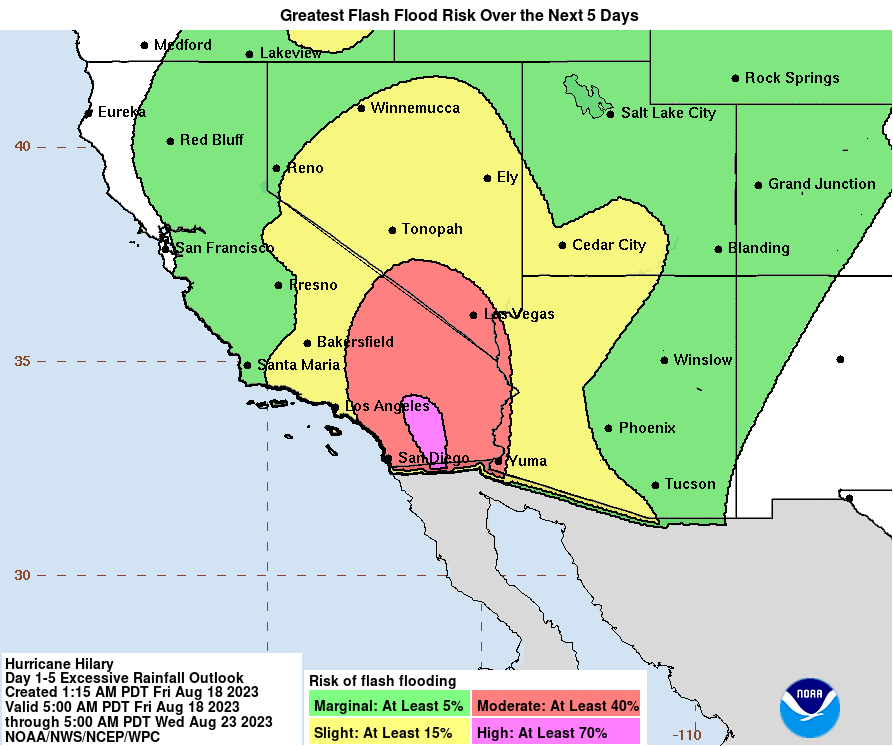
An exceptionally rare D3 high risk now issued. Catastrophic flooding is certainly on the table for some areas of the SW. Excessive Rainfall Discussion NWS Weather Prediction Center College Park MD 358 AM EDT Fri Aug 18 2023 Day 3 Valid 12Z Sun Aug 20 2023 - 12Z Mon Aug 21 2023 ...A HIGH RISK OF EXCESSIVE RAINFALL EXISTS FOR THE PENINSULAR RANGES OF SOUTHERN CALIFORNIA... Portions of the West... The guidance is unanimous in merging Hilary with an upper low stuck near central CA. Normally for a tropical cyclone this would be a problem as convective lows would circle the periphery parallel to 1000-500 hPa thickness lines, which would otherwise turn it more north or north-northeast, but since Hilary should be strongly shearing while moving over cold waters and transitioning to a post-tropical or remnant low in the process, it should have diminishing convection in its vicinity, so this isn't the typical model bias (this time). A large area of precipitable water values of 1.75-2.5" will approach if not exceed all-time time records, so there will be moisture to spare. In the Southwest in particular, flow at 750 hPa is expected to reach or exceed 65 kts, so heavy upslope rains on the atypical sides of the southern Sierra Nevada and Peninsula Ranges of CA are anticipated. If the flow is more southerly than expected due to a slightly more westerly track of Hilary, there's a chance that both sides of the Peninsular Range get heavy rainfall. The NAEFS is indicating IVT values 14.8 sigmas above the mean. Even assuming a non-standard distribution, this is extreme. There is a very real potential for 3" amounts in an hour in this environment. Some of the guidance shows local amounts of 7"+, which would be exceeding rare for the region from a tropical cyclone, potentially unique for Nevada. The 100 year ARI is forecast to be exceeded. If a 7"+ maximum materialized over Mount Charleston Sunday into early Monday, it would challenge Nevada's 24 hour rainfall record, set in 2004. Given the overall uniqueness of this event, chose to upgrade to a High Risk for areas near and east of the Peninsular Ranges of Southern CA.
-
I’ve had 3-5 1”/hr+ events this summer with one 2.54”/hr event. It has been nuts. EH is very vulnerable to flooding given our topography. Before flood control, approximately 1/5 of town would flood annually from the rivers and a lot more would be at risk during any rainfall events if not for our pumping stations.
-
1.25” in 40 minutes. 1.42” in an hour. We flood, again.
-
Absolute deluge here
-
Nasty at the shore. Nice lightning here and torrential rain coming fast.
-
Yeah I should have said snow rather than blizzards—that’s happened before. Being dramatic
-
I will readily admit I’m out of my depth here. Tracking tropical for the desert southwest is like tracking a blizzard for Miami.
-
Well that’s the thing, right? It’s probably great for the basins, but in those desert and urban areas it just runs off. If it verifies God help people unaware enough to travel into some of those parks.
-
98L, although convectively disorganized, looks to be leading the pack as it has a more robust low level spin and maybe some convection trying to organize. It’s the front runner tonight to be the first NS since Don, though a combination of dry air and shear will likely kill it next week. 98L is more convectively active but it still looks to be tied up in the monsoon trough with elongated vorticity and is still connected by my eye to the new lemon just to the west. That lemon, which the Euro continues to like, could become a player for the Antilles of it can separate. It should be noted that this region has been most convectively active, so it stands to reason if it can acquire spin and avoid SAL to the north given its location it has a legitimate chance. Meanwhile, nothing new for the Gulf lemon. Still worth watching but I don’t think we get a better sense of things until the disturbance reaches the Gulf.
-

2023 Atlantic Hurricane season
WxWatcher007 replied to Stormchaserchuck1's topic in Tropical Headquarters
98L, although convectively disorganized, looks to be leading the pack as it has a more robust low level spin and maybe some convection trying to organize. It’s the front runner tonight to be the first NS since Don, though a combination of dry air and shear will likely kill it next week. 98L is more convectively active but it still looks to be tied up in the monsoon trough with elongated vorticity and is still connected by my eye to the new lemon just to the west. That lemon, which the Euro continues to like, could become a player for the Antilles of it can separate. It should be noted that this region has been most convectively active, so it stands to reason if it can acquire spin and avoid SAL to the north given its location it has a legitimate chance. Meanwhile, nothing new for the Gulf lemon. Still worth watching but I don’t think we get a better sense of things until the disturbance reaches the Gulf. -
I’m not sure, but I spoke to a friend from LA and he said he’s hopeful this’ll act to suppress fire season.
-
Impressive improvement in appearance in just the last few hours
-
No special analysis here but Hilary is almost certainly a major hurricane now given the continuous improvement on IR especially the last few hours. Now it’s a question of how high it can go. (time sensitive)
-
1939 for a sea to land landfall, but I think 97 was the last time a designated TS was over CA. Yeah I’d sell that.
-
Hilary has the look. Might be a big time event in southern CA.
-

2023 Atlantic Hurricane season
WxWatcher007 replied to Stormchaserchuck1's topic in Tropical Headquarters
Interesting end to the Euro as that western area I just mentioned maybe gets left behind by a trough and the EPAC ejects vorticity into the BOC leading to a TC in the Gulf. Not really worth much headspace, just a reminder of how complex this overall evolution is--there will be opportunities for TC genesis though, IMO. -
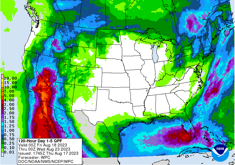
Considering that some of these areas don't get this much rain in a year, it could get real bad if this forecast verifies.
-

2023 Atlantic Hurricane season
WxWatcher007 replied to Stormchaserchuck1's topic in Tropical Headquarters
12z runs again show a complicated setup in the Atlantic, with a potentially weak system in the Gulf, high uncertainty (but low ceiling) for the areas along the disintegrating monsoon trough, and a long range potential for a CAG to develop. The Euro continues to actually focus MDR development further west, with a brief TC in the Caribbean before running into a buzzsaw of shear. Verbatim, it'd be a risk for PR and the USVI early next week. The Gulf thing becomes a weak system, but doesn't have time to consolidate enough to organize into something stronger. -
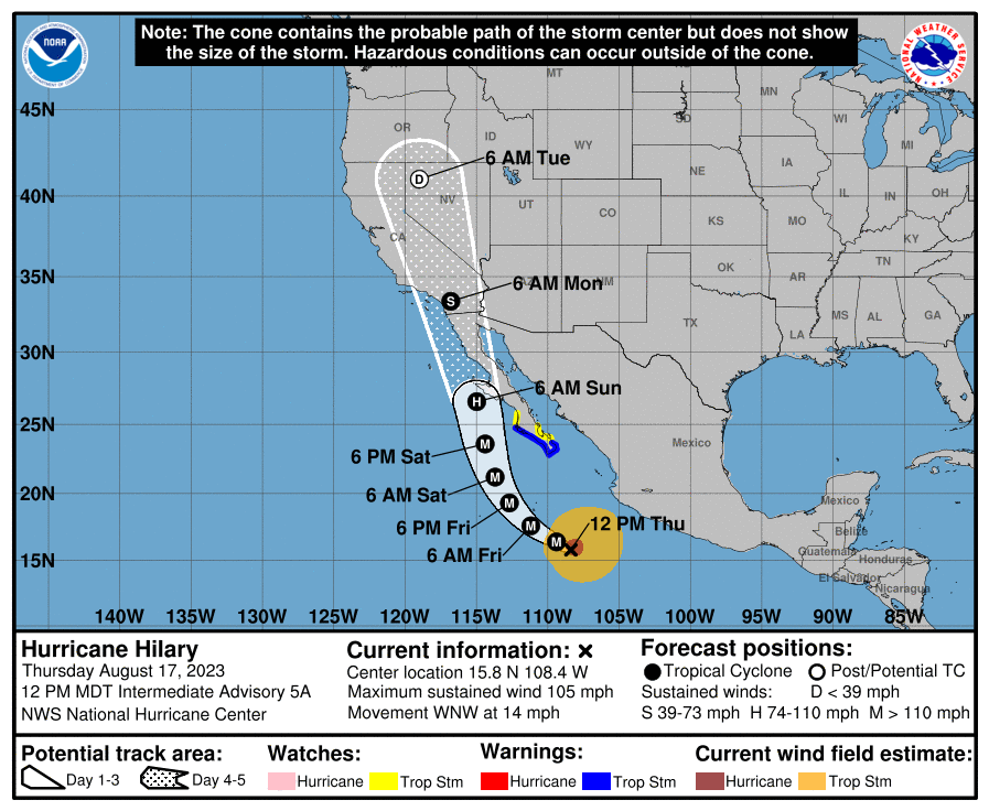
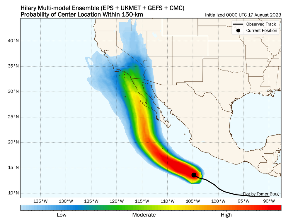
I know we rarely have separate threads for EPAC systems, but given the current NHC track and potential high impact in the SW US, I think it's worth a thread. Hilary is currently undergoing rapid intensification, with it attaining category two status as of the noon MDT (2pm EST) NHC intermediate advisory. As you can see on the recent IR image, an inner core has developed and we have an apparent attempt to clear the eye. The current environment for intensification is about as good as it gets, and this should easily reach major hurricane status. An anomalous steering pattern with an eastward shifting ridge and trough west of CA looks more likely, causing Hilary to move NW into Baja and potentially southern California. Despite the track and intensity forecast generally being solid, we still have significant uncertainty as Hilary approaches Baja and the SW US. In terms of impact, while it's novel to have an actual tropical storm in California, it looks like rainfall and flooding will be the main hazard, with a rare moderate risk for excessive rainfall for part of southern CA


