
David-LI
-
Posts
1,439 -
Joined
-
Last visited
Content Type
Profiles
Blogs
Forums
American Weather
Media Demo
Store
Gallery
Everything posted by David-LI
-
it's tough to bet agaisnt the euro
-
Yes but OTS
-
00z GFS
-
Mandatory “This is exactly where we want the models to be this far out” daily comment.
-
And Nova Scotia
-
My back is shot from shoveling for 24 hours. I guess I will be stronger for this storm.
-
GFS northwest and stronger. Might be a big hit.
-
It's a good model.
-
00z ICON OTS
-
So which model or models was the most accurate for totals including snow and sleet?
-
Any reports of thunder snow?
-

Extreme Cold, Snow & Sleet: SECS 1/24 - 1/26
David-LI replied to TriPol's topic in New York City Metro
canadian seems to stay all snow for the city, correct me if Im wrong -
Extreme Cold, Snow & Sleet: SECS 1/24 - 1/26
David-LI replied to TriPol's topic in New York City Metro
of snow or mix? -
Extreme Cold, Snow & Sleet: SECS 1/24 - 1/26
David-LI replied to TriPol's topic in New York City Metro

-
Extreme Cold, Snow & Sleet: SECS 1/24 - 1/26
David-LI replied to TriPol's topic in New York City Metro
If NAM is correct they should not retire it. -
Extreme Cold, Snow & Sleet: SECS 1/24 - 1/26
David-LI replied to TriPol's topic in New York City Metro

-
Extreme Cold, Snow & Sleet: SECS 1/24 - 1/26
David-LI replied to TriPol's topic in New York City Metro
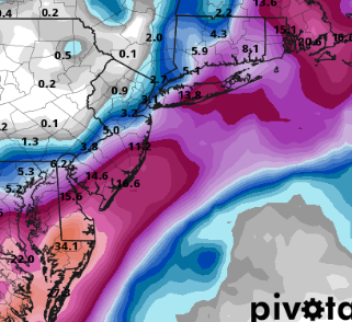
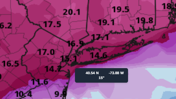
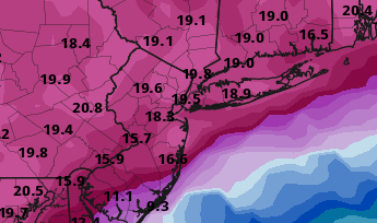
Is Mt Holly map still 12-14 for the area? -
Extreme Cold, Snow & Sleet: SECS 1/24 - 1/26
David-LI replied to TriPol's topic in New York City Metro
Keep these HRRR updates coming! -
Extreme Cold, Snow & Sleet: SECS 1/24 - 1/26
David-LI replied to TriPol's topic in New York City Metro
Wrap around snow on the GFS, still snowing at 1 pm on Monday. -
Extreme Cold, Snow & Sleet: SECS 1/24 - 1/26
David-LI replied to TriPol's topic in New York City Metro
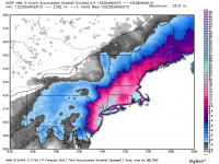
Based on the 12z GFS for Long Island, it looks like about 6-8 inches of snow before changeover to sleet around 5-7 pm. Then perhaps another 2 inches of sleet. I do not see Long Island with 14 inches of snow. -
Extreme Cold, Snow & Sleet: SECS 1/24 - 1/26
David-LI replied to TriPol's topic in New York City Metro
Not saying it's wrong, but the NAM 3k is best for very short range. -
Extreme Cold, Snow & Sleet: SECS 1/24 - 1/26
David-LI replied to TriPol's topic in New York City Metro
I think what they mean is, has there been a discussion and explanation why they think it stays mostly snow? -
Extreme Cold, Snow & Sleet: SECS 1/24 - 1/26
David-LI replied to TriPol's topic in New York City Metro
GFS with another threat for the following weekend -
Extreme Cold, Snow & Sleet: SECS 1/24 - 1/26
David-LI replied to TriPol's topic in New York City Metro

-
Extreme Cold, Snow & Sleet: SECS 1/24 - 1/26
David-LI replied to TriPol's topic in New York City Metro
GFS is a top tier model. Care to elaborate why you think it is wrong?


