David-LI
-
Posts
1,439 -
Joined
-
Last visited
Content Type
Profiles
Blogs
Forums
American Weather
Media Demo
Store
Gallery
Everything posted by David-LI
-

2/13 Significant/Major Winter Storm Discussion & Observations
David-LI replied to Northof78's topic in New York City Metro
What city in Canada is that? Or is it a city in Russia? -
2/13 Significant/Major Winter Storm Discussion & Observations
David-LI replied to Northof78's topic in New York City Metro
-
2/13 Significant/Major Winter Storm Discussion & Observations
David-LI replied to Northof78's topic in New York City Metro
NAM is not to be trusted within 24 hour range let alone 84. -
2/13 Significant/Major Winter Storm Discussion & Observations
David-LI replied to Northof78's topic in New York City Metro
I have a feeling this is the type of storm they forecast 2-4 but it ends up being 8-10 -
2/13 Significant/Major Winter Storm Discussion & Observations
David-LI replied to Northof78's topic in New York City Metro
Lee Goldberg snowmap coming up in 10 minutes. I'm going with what he says, dude rarely misses. -
2/13 Significant/Major Winter Storm Discussion & Observations
David-LI replied to Northof78's topic in New York City Metro
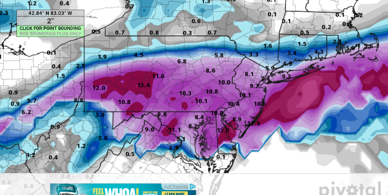
00z euro fresh from the oven
-
2/13 Significant/Major Winter Storm Discussion & Observations
David-LI replied to Northof78's topic in New York City Metro

-
Petition to not start a topic about this upcoming event, I'm afraid it will jinx it again.
-
way over done no? edit: I just realized that ends at hour 276 lol
-
Euro is rain. Either give me a 2 feet blizzard or give me spring already please.
-
Not same radar but I like channel 4 doppler radar https://www.nbcnewyork.com/weather/
-
How come no one is mentioning the canadian model? It's looking good
-
Two Mdt to high impact events NYC subforum; wknd Jan 6-7 Incl OBS, and mid week Jan 9-10 (incl OBS). Total water equiv by 00z/11 general 2", possibly 6" includes snow-ice mainly interior. RVR flood potential increases Jan 10 and beyond. Damaging wind.
David-LI replied to wdrag's topic in New York City Metro
Is that hail ? -
no thanks
-
Extended summer stormlover74 future snow hole banter thread 23
David-LI replied to BxEngine's topic in New York City Metro
-
Extended summer stormlover74 future snow hole banter thread 23
David-LI replied to BxEngine's topic in New York City Metro
How come Lee Goldberg on ABC 7 almost always get the snow forecast right days before the event? I've been watching him for over 10 years and he rarely misses on his calls. -
Two Mdt to high impact events NYC subforum; wknd Jan 6-7 Incl OBS, and mid week Jan 9-10 (incl OBS). Total water equiv by 00z/11 general 2", possibly 6" includes snow-ice mainly interior. RVR flood potential increases Jan 10 and beyond. Damaging wind.
David-LI replied to wdrag's topic in New York City Metro
Im sorry what? -
Two Mdt to high impact events NYC subforum; wknd Jan 6-7 Incl OBS, and mid week Jan 9-10 (incl OBS). Total water equiv by 00z/11 general 2", possibly 6" includes snow-ice mainly interior. RVR flood potential increases Jan 10 and beyond. Damaging wind.
David-LI replied to wdrag's topic in New York City Metro
uncle Ukie never fails. That's exactly what I'm expecting. Zero accumulation NYC east. -
Two Mdt to high impact events NYC subforum; wknd Jan 6-7 Incl OBS, and mid week Jan 9-10 (incl OBS). Total water equiv by 00z/11 general 2", possibly 6" includes snow-ice mainly interior. RVR flood potential increases Jan 10 and beyond. Damaging wind.
David-LI replied to wdrag's topic in New York City Metro
It's a good thing I didn't take down Christmas decorations yet. Should be a nice Sunday afternoon sipping on hot chocolate watching the snow fall outside. I hope it snows enough so the kids can build a snowman.- 3,610 replies
-
- 5
-

-
- snow
- heavy rain
- (and 5 more)
-
Two Mdt to high impact events NYC subforum; wknd Jan 6-7 Incl OBS, and mid week Jan 9-10 (incl OBS). Total water equiv by 00z/11 general 2", possibly 6" includes snow-ice mainly interior. RVR flood potential increases Jan 10 and beyond. Damaging wind.
David-LI replied to wdrag's topic in New York City Metro
You don't remember an event where NYC got more than 12-15 inches?- 3,610 replies
-
- 3
-

-
- snow
- heavy rain
- (and 5 more)
-
Two Mdt to high impact events NYC subforum; wknd Jan 6-7 Incl OBS, and mid week Jan 9-10 (incl OBS). Total water equiv by 00z/11 general 2", possibly 6" includes snow-ice mainly interior. RVR flood potential increases Jan 10 and beyond. Damaging wind.
David-LI replied to wdrag's topic in New York City Metro
You just got NAM'D!! (Now seriously, this is not happening lol, go home NAM you're drunk)- 3,610 replies
-
- 4
-
-
-
- snow
- heavy rain
- (and 5 more)
-
Two Mdt to high impact events NYC subforum; wknd Jan 6-7 Incl OBS, and mid week Jan 9-10 (incl OBS). Total water equiv by 00z/11 general 2", possibly 6" includes snow-ice mainly interior. RVR flood potential increases Jan 10 and beyond. Damaging wind.
David-LI replied to wdrag's topic in New York City Metro
I'm only at hour 69 and still no crush job, dryslotted then switch to rain after initial snow, do you have access to faster model runs? -
Two Mdt to high impact events NYC subforum; wknd Jan 6-7 Incl OBS, and mid week Jan 9-10 (incl OBS). Total water equiv by 00z/11 general 2", possibly 6" includes snow-ice mainly interior. RVR flood potential increases Jan 10 and beyond. Damaging wind.
David-LI replied to wdrag's topic in New York City Metro
It's the NAM so take with a grain of salt. Coming in colder than 18z. Precipitation arrives in the city by 4 pm Saturday then by 7pm everyone is snow. 3.5 inches of snow in nyc by saturday 11 pm. Unlikely, just what weenie snowmap is showing. -
Two Mdt to high impact events NYC subforum; wknd Jan 6-7 Incl OBS, and mid week Jan 9-10 (incl OBS). Total water equiv by 00z/11 general 2", possibly 6" includes snow-ice mainly interior. RVR flood potential increases Jan 10 and beyond. Damaging wind.
David-LI replied to wdrag's topic in New York City Metro
Snow shower? Are you in Buffalo or something?