

Typhoon Tip
-
Posts
44,565 -
Joined
-
Last visited
Content Type
Profiles
Blogs
Forums
American Weather
Media Demo
Store
Gallery
Everything posted by Typhoon Tip
-
Yup... PNA rise, too - That featuring fits inside the Jan 28 - Feb 5th ( ~ ) window of fairly classic teleconnector signaling... In this case, the latter of which may be more trustworthy because of the 'telecon convergence' - ... Think of that as having two disparate statistical inference regions ... coming to the same conclusion at point X ... in this case, we be point X, and the disparate regions are the PNA and the NAO. Either has a correlation to exciting/preceding a NE storm in their own right -
-
May not be a bad presumption ...no - We've seen "-NAO winters" do something like this in the past often enough, where just when we think the -NAO is gone... it just starts festering back into the future guidance. Personally, I've stopped looking at the NAO ...because I firmly believe the NAO is a manifestation of non-linear forcing downstream of the Pacific wave dispersion shit ...anyway, and the directive to focus on that region really should be just used to show that said processes are taking place - In other words...the forcing is coming from the Pacific in the latter wave function - it's really the type of concept and understanding that will resonate clearly in this social-media bubble, sure ... Anyway, for storm enthusiasts, ... pulsing the -NAO back to nuetral or modestly positive, rinse repeat .. probably situates events when it is rising... Then, limiting the realization going back the other way. It doesn't mean there can't be events and interesting stuff to track on the off-cycles of course.
-
I posted this in the tired January thread .. not realizing this one was/is active: Multi agency PNA monitoring suggest either a mode change to modestly positive, or, a neutralization of the erstwhile negative character of that index. ( Edit, this concerts with what Will is saying about support from different sources ...) The NAO obolishes ..or, at least this current rendition of it - being a west based exhausted elephant that's decided to set it's ass down over eastern N/A. Rising PNA of any kind during an NAO block decay sends a modest Archembaultian 'correction event' vibe through the hemisphere. This would time during the January 28 - thru about Feb 5 span of time. I wouldn't be argumentative if anyone advanced discussion over anything in that time frame already on the charts, or in surmise ...were guessing something may emerge in the guidance. As a quick exit point, there are semblances of the -EPO in some operational cycles that I'm seeing occasionally as of late. These may be figments of an underlying detection for the former change in the PNA ... sort of an obscure confidence that 'some'thing is trying to snap one end of the bed linen over the next 10 days.
-
I looked across the last four cycles of that model and frankly ... it's amusingly sensitive to call that 'back to nothing' - hahaha.. I mean, the other way was almost meaninglessly more. The variations between those runs were quantum scaled nuances ( hyperbole but to make the point).
-
Rather ironically ... there is a prediction I can make that 100% certain in this roughly three week stint of -NAO ... whilst an unpredictable, unmanned fire-hosing frenzy spills in waves from off the Pacific: - eyes will roll at the following op-ed Oh,...okay. I'll employ mercy and keep it to a few bullet points this time ) Multi agency PNA monitoring suggest either a mode change to modestly positive, or, a neutralization of the erstwhile negative character of that index. The NAO obolishes ..or, at least this current rendition of it - being a west based exhausted elephant that's decided to set it's ass down over eastern N/A. Rising PNA of any kind during an NAO block decay sends a modest Archembaultian 'correction event' vibe through the hemisphere. This would time during the January 28 - thru about Feb 5 span of time. I wouldn't be argumentative if anyone advanced discussion over anything in that time frame already on the charts, or in surmise ...were guessing something may emerge in the guidance. As a quick exit point, there are semblances of the -EPO in some operational cycles that I'm seeing occasionally as of late. These may be figments of an underlying detection for the former change in the PNA ... sort of an obscure confidence that 'some'thing is trying to snap one end of the bed linen over the next 10 days.
-
Disagree with what ? ..." Is it likely probably not. .." - the point was just not to do this 86 autopilot act that's really based upon emotion - not you per se but it's palpable and equally annoying. Boxing Day was a significant cyclone that was routinely taken E much in the same way and corrected N in the last 48 hours ...sending NWS scrambling to get blizzard warnings out to a non-suspecting demography ...and the regulars in here rushing to make up for the 5 dayls worth of 'model cinema heroin' they missed out on... Granted, there's been modeling upgrades along these tail-end of Moore's Law in technological advancement years since, ... in theory, improving the A.I. engine of the models...But, not joining in with that faithful congregation inside that temple of our electronic gods, in an era that's inherently got almost N/S in the mid ranges ..might just be a healthy degree if incredulity and skepticism - So, if you disagree with that? Okay - I got no problem with disagreeing LOL... Look, I'm not a meat ball either. This winter is a donkey dong boning for the snow enthusiasts. I am a sympathetic, empathically aware human - unlike the girl of my dreams that recently turned out to be a sociopath ...but I digress -
-
Premature post Anyway that’s a plausible explanation for that as far as the 29th is concerned I still don’t see why that can’t be corrected North. … Which is to say I’m not willing to remove that as a possibility yet. Is it likely probably not. I tell you though the GEFs locks the ridge axes over the Dakotas and then pushes the trough out to sea .. that doesn’t make any sense it extends the wave length without having any systemic mechanical device to do so in the larger synoptic evolution of the pattern
-
Cheer up guys… how to console the inconsolable so I’m not going to bother… But I’ll say it makes sense if the euro can’t see the 26 because it digs too much in the southwest at least excuse imaginable and when it does that it lifts the flow over the Ohio Valley to compensate and that tends to damp out leading wave spaces
-
That westerly spread is just as ominous
-
yeah no this GFS run is again showing inconsistent handling of the eastern Canada and conjoining western limb of the NAO domain eddy - 00z the GFS had limited to no SPV fragmentation/interaction dropping in... 06z teensy bit more...12z adds another pinch ..now this one tries to bring it down again... Which is pushing this out because there's no way given the speed surplus of the jets involved can that capture and phase - so the only other option is to kick - but, we still have 120 hours to iron this out and that handling of the NAO space dictates what pushes that shit south vs leaves this thing along... Alone I feel it has enough to correct N in time, and the ridge, W, is positioning near the Dakotas and that is climate friendly to an EC strikes. ... The other aspect is that the entrance region for the escaping jet fields off the EC are probably being flattened by said -NAO exertion... Hence the due east motion of the deep layer... All of which is open to modulation in my mind but - that's not a forecast. Just a suggestion of what to look for on these next few runs. When something of a bit more power got ingested into the grids/initialization of the 00z ..that's when this began to look better back east for storm enthusiasts. A stronger realization would help the lead S/W ridge rollout ..and feed back - ways to go here...
-
Yeah... agree with Scott re the GEFs... Noting the spread at TT is over the NW arc - tends to incline where the correction is more likely to occur in future cycles... I would also remind as I am sure for those with experience would concur ...this is a candidate for the N correction if I've ever seen one. And seeing the Euro outside of it's wheel-house trend even a little is right on that... Next run's a litttle more? Than a again...then we're in..and we're still over the 4 D threshold.. It eerily portends to this member smear .. We'll see - I too am not immune to the rigors of a punishing ennui/uninsprired atmosphere at least excuse imagined persistence ..but, struggling to maintain objectivity as it may be to do so.. I cannot preclude this thing not striking N of the M/A proper latitudes. This is all at this point predicated on the assumption that the -NAO exertion/suppressed storm track is being handled exact ... very sensitive however. Slight nuanced if yet even undetectable to the almost 'unaided' eye may mean critical 3 deg latitude in pass ... and to re-iterate, big systems move small amounts and that involves disproportionately larger areas. Plus, this 12z GFS still looks like an OES meso concern for eastern Mass and SE NH/Cape ..That's a very cold antecedent air mass on a long shore wind getting set in there and I suspect that's grits everywhere in 22 F sting...with some streamers to 1/2 mi visibility ... Too detailed for this range?? absolutely...but it goes along with the trope about 'not focusing on the eye of the hurricane' - this is the most powerful system of the season and appears with these subtle ridge alterations ...mm, sneaking up as a hemispherically footed deal - whether this hit or not...
-
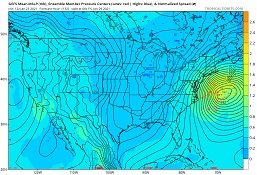
Something got absorbed into the GFS 00z initialization overnight S of the Gulf of Alaska. It had triggered an immediate physical response ... culminating in significantly deeper, larger down stream result during the 28-29th. So, as we know they're now modeling high impact risk scenarios ... cute. What leaps out at me is that these models are less 'weird' looking, though? Prior run had variant depth and middling sized handling, cycle to cycle, ranging from due east motions, to unrealistic SE motions from Cape Hatteras to S of Bermuda ( at exotic pressure depths )... Stuff that's not impossible - no. But less seen historically. Just in general 'spraying' solutions within that envelope of poor continuity. Now ? - far more climatology apropos for one. But the 00z to 06z GFS just look deliberate - sometimes ya just gotta say it that way. And, when trends do that and not the other way - lending to distraction - that always raises an eyebrow for me. Passing through the mid range? mm..that times to Pacific data-assimilation issue frankly, as suspiciously culpable. So far these trends still limit along/astride the middle EC, but by virtue of size and how these depiction integrate the surrounding synoptic medium, there are extended concerns that give us our own headaches this far N. I would option for more impact up our way, though It's a long time at 120 hours in this arena of low skill, to maintain such a delicate placement of an elephant that big. Any subtle 'giga' motion in the model handling of a system that large ... can implicate a beefier output/impact over regions that are comparatively small relative to the size of the entity being tracked. Sort of like looking at a boulder careening down a ravine from across a valley, but when you get up close you realize that the boulder was the size of a Colonial mansion ... You bump this entity 100 naut mile N of the 06z GFS track, you got blizzard conditions in Providence - There is a bomb here... thunder snow wind acceleration, ...slow down do to torque resistance.. The whole shmack in the scenario for DCA-PHL/NJ. To me, it is somewhat reminiscent of 'PD1' ... though I don't care to get into whether that's an analog, just in practice/behavior. This thing may NESDIS' the hell out of that region, with light snow and biting wind and nastiness to the Pike. Whilst virga undulating skies tickle tendrils to tree tops, flurries and grains ... teast to S VT/NH. Headache 1: ... OES is a factor over eastern zones, S of PWM. The 06z even models a QPF streamer extending a thousand KM hosing into eastern MA.. But, the thing's circulation is massive...it's has a long shore fetch emanating deep in the Atlantic, where there is going to be a mixing in the 850 to 925 mb levels of that moisture source with nascent polar-arctic air aligning to the N, helping to ignite activity in the mixing of the column... It is risky to speak of such details... I am not forecasting that? I am attempting to elucidate the challenges of a system that large and the kinds of extended concerns that will smear N. I'm also wondering about tides in that... If this thing does slow down taking a couple tide cycles to succeed the distance from the Del Marva to the outer G-string waters before truly pulling away, ...at 965 mb depths and a +PP draped over SE Canada means there will be a oceanic response ... long swell arrival during a high tide or two. All this on the table... Headache 2: ... regards the surrounding synoptic idiosyncrasies that are sort of esoteric or obscure about this thing. It should be noted that the GGEM has been a N. outlier all along.. It is hard to say if these GFS trends are joining that camp, or if that camp is lucky, and this sudden movement toward a deeper systemic vastness and overal structural just happens to align. But the spooked aspect deals in synoptic super-structure. The flow scaffold is trended toward less 'curved' tendency exiting the 35th parallel extending E of the coast into the Atlantic/Bermuda particularly sneaky in the last 2 to 3 cycles. It's a "behavior tendency," not so evinced point to point in runs. The GFS/GGEM want to hold the axis of that ridge back toward the Dakotas (~) .. Hello! That is the climate axis for nailing the shit out of DCA-PWM. So DCA-PHL/NJ impact scenario is has the historical inference; whether that comes further N is also acceptable - just not modeled so much at this time. That is probably owing to the large NAO circulation - which may in fact be crucially modulating/correcting an amount that brings this just enough. I've seen these deformation smears lift N inside of 84 hours before. Jan 6-9th of 1996 did that... I cannot rule that out at this point... no way. Not when noticing the behavior trend to limit the SE calving motion of the previous solution ..correcting N, and, noticing the upstream riding/positioning. I don't know if these trends are finished at 120+ hours in an intrinsically bad model performing hemisphere ... The NAO ( or transitive Pacific influence; whichever one wants to blame) is a tricky and delicate matter off the EC. It matters, because the above tendencies are already creating a correction window to bring this N in these guidance'... I don't believe the Euro is infallible in this regard. The GFS may even lose this signal again... But I wouldn't bring it off the table if it does...
-
Yeeeeah ...that I believe is a threshold question ? It deals with starting at -40 C ( ...picking a deep value for the point of discussion ...), and having to move that needles +20 C, before the poles stop exerting as much push back against the warming middle and lower latitudes. In the interim ... lots of gradient regimes. There's some wiggle room there... And because the polar starts at such a low point, moving vast amounts is a physical availability issue/budgeting based upon mass. That area up there is small relative to the whole areas outside of it integrating the warmer world. These outre regions warm ... 3C ... that inputs a lot of mass into a smaller domain space, such that the said smaller space may move it's needly by multiples of that same input to atone for the thermal potential. Think of it this way: an equal mass of ice mixed with an equal mass of liquid water, will mix to some temperature. But, take the same mass of liquid water, and mix it with two ice cubes. The end result is colder. In this case, we're talking about 1 ice cube and an order of magnitude more mass storing its therms to share into the ice cube...so the ice cube is going to move more. At some point though, the ice disappears, and it's rate of change slows. It is at this point the the whole atmosphere attains a new paradigm - one that may feature 200 m of oceanic depth increase because Antarctica is officially entering glacial rebound/geology ... Not in our life-times ...but we're being tongue-in-cheek a little here.
-
Great question! Short answer? I don't know... Somewhat longer answer, I have not been able to find any source that calculates that metric - but I think it is worthwhile; and some grad students with ambition and access/wherewithal should really do so and earn themselves a dissertation. Because, the airline industry has been setting ground -based trans-oceanic speed records now regularly for the past 20 ... and more so, 10 years. Plus, pattern and teleconnector inference headaches.. you name it.. Understanding the wind increase and how that feeds back into the R-wave modulation/global atmospheric mechanics of the general circulation isn't just pissing off snow zealots in social media, it clearly has a practical use in the fuel industry and the general risk assessment arenas to name a couple...
-
Cool loop! Keep in mind... that's the "stratosphere" ... The issue is the PV in the troposphere - that's what counts for terrestrial experience/interests - I am having difficulty finding direct evidence that the -AO has really been driven by the stratospheric --> downward exertion... In other words, are/were they truly coupled? This -AO is residually predating that apparent SSW event in the first week of this month. SO, if there is a couple tropospheric response, it is not likely to have happened yet anyway, because the total model has a ~ yet still coherent three week lag correlation to tropospheric mode transition to negative wrt to the AO. I mean...not that you are refuting any of this .. heh.. Just sayn'
-
ah, you beat me to it - I just posited the same sort of gist ...
-
Plus ...keep in mind, all this consternation could be true, and there's still the random 2015 - ... These are not absolute limitations... it's like everything in nature, however - we deal in a reality governed by probabilities. It's just that when a given system gets f'ed around with, it changes the machinery of said system, and it producing differently. GW ( leaving the "A" out of it ) ... changes the machinery of the atmospheric system. So...you know, suppose probability says that 60% of the time you will see a certain flavor of outcome, means one happens to be more likely to see said outcome at any given point along the way... blah blah... The thing is, as of 2007, the Special C Report flagged the expansion of the HC ...based upon the 1980 -2000 data ... That was 13 years ago, concerning a time span that years prior to that ... Do we think that's gone the other way with age ? - hello As of that report, the expansion was estimated to be 3 to 6 degrees of latitude. And we have 'hockey -sticked' the climate since. I don't know...but, integrating a 10 deg latitude expansion through a boreal winter ...that's probably enough to atone for fast winds. Here's the other thing...Those fast winds, I think... are causing polar indexes to register more positive, because it speeds up the flow - that mimics a stronger PV in general. Talk about the 'teleconnector interpolations' changing - yeah. Yet, all of this stuff needs a decade or two to get proven, and if all this were not enough...it seems these systems are also changing now faster than humans can spin out said proofs and actually have the consensus except them. Hell, we still call it "The General Theory of Relativity" ... when there is no empirical data that supports it being anything less than Law. And it's been 100 years
-
I have a hypothesis ... why these are taking place. Firsty, I don't believe the demonstrative recurrence of either autumn or spring substantive cold over eastern N/A is mere dicey ...I think it is rooted in large scaled changes to the climate. These are narrow opportunistic times spans, inside of which .. the gradient richening of the total circulation is enhancing patterns that can deliver cold, earlier and later.. But, during the winter proper months, said gradient gets so extreme that we end up with a lot more destructive vs constructive interference maelstroms ... This is blunting events from happening during those meatier winter hemispheres. As the atmosphere's passing back out of the that regime ...it passes back through a normal gradient as the wave lengths are shortening, and that offers a narrow window of cold insert ( May ...) but this is opposite passing the other direction in Autumns. I think the autumn and late cold snaps ,... are probably related to the same forcing, as it is heading in opposite directions. But that by virtue means that yes... October may not portend winter, but knowing why ... a fast ambient atmosphere/destruction of wave harmonics in lieu of conserving torque at very large R-wave structures - is just not something the hemisphere is going to achieve as a base-line state in October or November ... Or as proficiently going in the other direction... In a sense, you could flip this argument around and suggest that a shitty f'um late January somehow implies a "great" April - heh...if you like 40/38 drizzle with a synoptic glopper... Personally, I'd rather not burn fossil fuels and get back to Currier&Ives Januariers lol
-
That's sort of what I'm thinking, in principle ...I mean, only the bat-shit crazed fantasies of an obsessive 22 year-old woman's crush would ever 'count' on 70s and 80s occurring twice in the same decade, in February - ( although this GW ..and we are on a metaphoric 'hockey stick' change ) But the gist of it. A warm up ...perhaps a lagged 'thaw' not atypical to mid winter lore is viable ... But in this day and age, yeah...good luck guessing how limited the extent of that is. The thing is, the 2018 warm spell happened after February 10 and although that is not taken very seriously, it matters. You need to have the solar input ... The sun is feebler prior to the ~ date, and it makes huge difference passing that 'electromagnetic fluxing event horizon'... I remember that Dec 2006 and 1999, ...we had 70 F in SE ridge dominant pattern(s)... with 850 mbs to +12 or even 15C !! 70 F ... On Feb 15, on the warm side of said virtual boundary? that's 80 - ...I mean, provided other circumstances with cloud and saturation are not skewing heating potential...etc..etc.. But I could see a warm up ... but the problem with the deep field notion of March 2018 walking through the door... I don't think this is the same hemisphere frankly so that end of it ... well, I don't typically engage in seasonal outlooks. Because I'm not good at it.. lol - but, I would surmise that an (HC + La Nina base-state )/2 ... probably doesn't = cold spring ?
-
It's hard to remove one's humanity from this involvement - if we were as unmoved, and un-emotively guided as computers, there would have been no posts in the past 10 days due to overwhelming logical influence of low probability of returns in this overall set up. We've been pining and posting truth-evasive spin ...while troughs through California transit en route to Arizona...have downwind stretched ridging ... in the means, extending from the front range of the Rockies' longitudes, with some 10 or 12 isohypses rising over the bulge... and what? did we actually think there was hope in getting a S/W amplitude in the east ?? this is commiseration - not trolling ... but, all the erstwhile the PNA has technically been positive at CPC ( oh, btw - ) yikes. What happens (then) when next week it plumbs to some -2.5 SD nadir, at the same time, and actually supports that sort of thing. So the NAO relaxes ( thank heaven for that much ..), but rising NAO that in fact goes to +1 at GEFs-CPC, with a 7 to 10 day neggie PNA ...usually lifts the westerlies over eastern N/A; and since the exertion comes from the S in the expansion shit (always exerting) that's all a constructive interference for warmth I'm afraid. So, the problem I have is that it smacks to me as a huge warm up ...just like when I see a chance of a big storm way out there, the other way ... Sort of synergistically inferred, where the models merely have yet to depict it - I almost sense similarly, that when the NAO decays and the PNA is still passing through that nadir ... we could see the models start doing a February 2018 ridge ... I've been toying with that the past several days - haven't said anything as I am sure that such an insight will garner a captive audience in this particular social media'sphere LOL Edit, as an afterthought ... the AO and SSW stuff ... it should be exerting now. It's hard to separate though, because the AO was successfully sustaining a negative index for the month or so prior to this timing. Moreover, presently the AO is forecast to raise to near neutral ... before ?falling? more modestly later on in week two. That's not very convincing that this SSW is really exerting and it is also questionable - to me - that there were/are other planetary mechanics going on that may be damping that input altogether. If that's the case...February is naked -
-
Yeah, it's called the 2004 (?2002? not sure) but ALCS against the Yankees back in the "Surviving Grady Little" years of infamy and dodging success in creative sabotage. It's the bottom of 5th ... 'Sox still leading 5-3 ...but the Yank's blooped a guy on first, then again ... after a teaser strikeout betwixt. And there they were, Pedro's ego and Little's enabling lack of ability to impose any intelligent will to the scenario, separating happiness from the fan-bases destiny that fateful autumn. So with a guy on 2nd and 1st, one out, and a full-count at the plate ... you knew. Hey, we were winning ! It was 5-3 at that instant of mordant prescience ...
-
Kidding aside ... -- teleconnector inference as an 'art,' and even to some extent a practicum .. have both become 'usefully blurred.' I don't know if anyone's noticed this - I have.. I've opined at times over the last couple of years - but one could more successfully 'flavor' their mid and extended range patterns accordingly, years ago ..more like decades, and their visions turn out charmed. It's getting harder to be reliant. A 1980 spread of indices ...does not seem to connote the same scenarios as they do in present era/years. I am not sure if the speed of the hemisphere's base-line velocity increasing has anything to do with it. But there is a seasonal lagged expansion of the HC ..intruding deeper into colder months and higher latitudes of the winter hemispheric states ( or, maybe it's just angels hating this social media's eclectic snow zealotry fan-base - lol..) But there has to be a reason why it snows in October and May so aberrantly compared to the 300 years of crunched climate numbers prior to the year 2000. Oh, we know it has snowed in October and May ... but that's also myopic. The point is increasing frequency ( as a metric indicator for change), combined with, not just 'may' or 'october'... Springs and autumns being apropos. It's only been five times in ten years, in a medium that's what, ... 500,000,000 years of geological consideration - So taken fwiw, those five years we've suffered dearthy midriff winters while introducing this book-ending futility phenomenon. Keep in mind, there is no northerly 'edge' to the HC. Ha, just like 'climate change' - it's invisible, so it has no direct advocate that appeals to the corporeal senses, and to 90% of human life...that of course means it can't exist .. It's an amorphous...virtually seamless transition terminating its cellular circulation eddy, rendering to the polar trade wind zones in a non-fixed latitude, no less, to really complex the hell out of the discussion... But it is all morphed(ing) and exerting - imho. A -2 NAO in 1980, even west based and similarly positioned blocking mass in space and time, probably should not imply the same over the eastern seaboard of the CONUS...due to morphologies in R-wave modulation, and the fact that tele's tend to break down and transition to new phase states faster in this modern era, too. The problem with phasing is because there is too much wind velocity ...because in the means, this is disrupting the critical x-coordinate wave motion with respect to the y-coordinate wave motion, when the S /streams are in the process of bi-passing the N /stream impulses. It really is wave harmonics vs inharmonic interaction/proficiency therein. And since the HC expansion started getting scienced by NASA and private think-tanks and f'ing math ... this velocity shit has arrived precisely in tandem. I dunno... quacks like a duck, we be f'ck'ed for standardized previous century models. I mean we'll get clocked eventually .. my guess ? it'll have some "air" of oddity in/of 'how in the hell did that happen'
-
It'll be 46/44 every day until May 1 in order to aggregate the warmest 60 days in history ...relative to climate -
-
That would be something though .. That low sheds 25 mb in 12 hours there on Cape Hatteras and pounds Norfolk VA with 2 foot ....a location that may average .15" a year - lol... Hyperbolic but still - probably in the ball park
-
Yeah I've been noticing that too... Helps to carve out/complete a REX structure ( -NAO ridge over Low couplet ) those are like a pawn-bishop defense in Chess -


