Typhoon Tip
-
Posts
44,476 -
Joined
-
Last visited
Content Type
Profiles
Blogs
Forums
American Weather
Media Demo
Store
Gallery
Everything posted by Typhoon Tip
-
Perhaps ...I dunno - but the top image I provided does not contain an SSW... when every year that has one, looks like the 2006 example I provided - or a closer approximation. I have also seen those warm 5 and 10 mb nodes pop off and not down well as I've been monitoring this shit for decades. They are not provable/statistically significant modulators prior to the onset of -AO... Again, the AO this time predates even those 5 and 10 hPas this year - I guess I respectfully disagree - I don't think we've had an SSW that matches the behavior set of historical inference. I think there are some coincident behaviors going on - ... we'll see how the rest of the year goes. Also, the QBO is not in the typical phase for SSW ...it's not a deal breaker or nothin... but usually the QBO is in the easterly phase -
-
That's a nice two-stream subsume phased solution there... The starting heights are not overly deep - but that's been a part of this pattern and may be residual as modulator leading those mechanics.. That said, that appears be structurally quite proficient so, it may actually "core" that mess out once that gets more phased in and the total cyclogenetic feed-backs start lower heights from synoptic lift and [ lots of popsicle headache ...] leads to be deeper relative to the input streams.
-
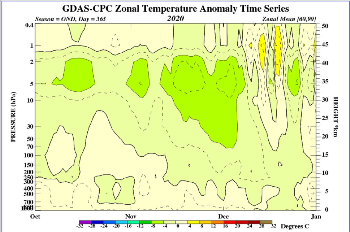
I've been waiting in the wings on this topic - I don't see where an SSW of the ilk that matters to "forcing" on the AO has actually happened. Granted, the monitoring has suspended as it normally does flipping the new calendar year. Probably when they get back in office/recovered from PTOs around the holidays they'll update the last week's worth ... but prior to that, there was no SSW in the typical channels that are given to the free/public access: Those small yellow pockets up there in the 5 to 30 hPa sigma levels are not it ... those are normal thermal 'noise' that is typical at suspension and decay ... What one should be looking for is this ( left hand side): Someone out there in the e-din of the social media ...where it overlaps more convention social comms of the society - new's paper/tele/radio etc... - is bandying claims of SSW and it's beginning to bag as that source not really understanding what it is they are looking for ... Now, I have been 'waiting in the wings' because I am not entirely certain they may have some other monitoring method/access out there; it may be possible that the method used by the CPC just hasn't detecting it but more on that below ( 2nd bullet point ..), but it seem unlikely that would be the case. 1 .. SSW are prominent features that are discernable, like is seen above - please see this site and evaluated years past, and you'll start to sense that this is not happening(ed) this year to date. https://www.cpc.ncep.noaa.gov/products/stratosphere/strat-trop/ 2 .. They are coherently disruptive in a lag correlation that average 20 days. Why? Because the kind of thermal pulsation en masse that we are looking for in SSW phenomenon, downwells in the atmosphere as a (literally) downward moving mass of warm air layers ...You can see that in the above image... a year long from 2006. That year featured a very strong and clearly defined SSW, and you can see ( left ..) how the pulse of warmth moved downward as the x-coordinate ( time ..) along the bottom aged on. You can see also it was nodal in nature, with a warm arc having a centroid warm mass the appears approximately once a week...that's because the warm pulse rotates around the pV as it descends... while the pV over all is warming... Notice also the cold coupled that emerges over top - that is the complete circulation eddy of the SSW phenomenon... 3 .. None of that has happened this year according to CPC's 30 years of data to use as inference - 4 .. What has happened: There has been a peculiar semi permanent warm node at around the 50 and 100 hPas that has persisted over NE Siberian/Kamchatka/Alaskan regions ... I suspect - though am not certain ..only suspect - that whatever source(s) are hitting the SSW so hard are or have mistaken that as being an SSW... Regarding that a .. there are almost no SSW since monitoring began that have ignited in October or November... In fact, the earliest I think is early Dec. b .. in order for the propagation timing of the 20 days to be stablizing the pV and causing it to break down ( -AO ), it would have had to take place by early December to be forcing now. c .. the present -AO predates any consideration before even having this discussion. The AO can be motivated to fall from the normal Hemispheric tumult - in the off chance that warm anomaly is in fact being mistaken: those positive anomalies in the 100 hPa level we see up there did not arrive from top down - no they did not... They were instilled into that region prior to any normal SSW gestation that is the correlation model for forcing the -AO, during the mid to late autumn via other mechanisms.

-
Here's an odd one... the 00z Para psychosis GFS version takes a 985 mb low passing SE of the BM down to 953 mb in just 6 hours ... That's RI/TC territory there... In fact, I don't think I've ever heard of that kind of deepening rate like ...on Earth
-
Yeah... low is anchored out there ... and bands are moving west ... There's even semblance of a small eddy gyre over Upstate NY ..quasi attached to that mess. The whole thing is intrinsically in retrograde characteristic, and whether the NAO is demonstrative in the grids or observations, that retrograde behavior is consistent with -NAO. See, I mentioned this last week - that sometimes the flow begins to act prior to the onset of the actual index presentation - it's like the physical triggers are detected in the model(s) physical process before hand. I don't know if that's really what's happening here - it just reminds me of that conversation. Either way, this day's banded west movement was pretty heavily suggested by guidance over the last four days of denial that this thing would miss - ha. And staring at those sat loops because it's like anything the swirls! yeah... heh, anyway, it's almost easy to see how a Feb 1969 can set up - if that thing out there was rattling around between Cape Cod and D.E.M. ..it'd be sending consecutive intervals of moderate snows in to eastern NE
-
My own meaningless twaddle ... - i get what Scottness is sayn' The term "suppression" in so far as what it means for this social media means 'mashed too far S to get our euphoria fix' ...? lol.. However, the flow is suppressed out there in these looks, either way. That's why I like using the word "compression" - because it removes that other distinction and just refers to the overall setting as too many height lines and the flow has to speed up to the point where it starts shearing. So, this is a semantic clarification more than anything, and it's based on my rules ... so not likely to be adopted. Understood ... - re the NAO ... mm... I see what and why mr Webb on the Web is suggesting both a -EPO and -NAO "get to happen" like a lip-wetting greedy safe cracker that's just broken into Fort Knox.. buuuut, I'm willing to hedge that if the gradient rich look returns with that nice orderly faster R-wave construct from Hawai'i to Halifax like that... the NAO gets fire hosed off the charts. I suspect the recent NAO is really more of a "flop" wave mechanical result of a relaxation everywhere that took place when the main ballast of the PV dislodged and slipped deeply into the western Pacific/+WPO monster. When that happened...entropy of patternization swept into this side of the hemisphere - and there's a reason why we see this nebular look with shallow cut-offs dappled in between an array of vaguely anomalous ridging nodes... It's because there really isn't a very well defined systemic layout of R-waves on this side of the hemisphere at present - it's changing though.. The guard appears to be trying to go back to the placing colder seasonal heights into middle Canada...and when that happens, the gradient steepens everywhere, ...flow speeds up ...boom, +PNAP more like emerges out of the ether once that focusing mechanism is turned on... Caveat emptor: the -AO ...That's still a whopper negative out there even into week 2, no longer correcting up ... Yesterday or the day before, all members of the GEFs camp were trying to signal a neutralization of that index into week 2, but suddenly, ...8 of the 12 members used at CPC have returned to -3 or even -4 SD... AO shares domain space with the NAO but only partially ... there is a disconnect, and we can certainly find plenty of examples of -AO/-EPO/+NAO ... - part of the problem is... the HC. Don't think that the expansion stuff isn't prevalent, just because the flow is currently 'relaxed'. It's still there, it's just not being exposed - that happens when the colder heights return ( or attempt...) to mid-latitudes.... That ~ 3 to 6 dm of insidious GW surplus ( comparing previous climate paradigm) still integrates Below the 40th parallel ( probably closer to the 35th ), and it doesn't vanquish. When the cold heights return, the gradient extends over larger distance anew...and that drives wind rage.. evincing the existence by way of resistance - sorry about the rhyme. The gradient increase in the large scale, and the faster hemisphere is like the UV lamp/'black light' in this sense. Again... I'm not just being whimsy...this still is covered in the special climate reports, as well as clearly stating that the boundary that demarcates the HC's termination into the westerlies band ( which in itself demarcates the interface between the HC and Farrel Cell at higher polar latitudes), is amorphously defined - SO now that no one has read this far ... I suspect we are heading for a -AO/ -EPO more so than -NAO ... I also wonder if the -EPO is unstable... I say so because the WPO ...in the atmosphere of 1955 - 1980 ... It tends to precede the EPO, positively correlated by time lag in the latter aspect. I am not seeing the WPO as falling --> AB Pac --> -EPO evolution...I'm just noticing the -EPO ...it's not a stable hemisphere. But here's the interesting supposition - I have opined in the past about how the teleconnector climo appears to be rattled by much of this climate change shit.. I wonder if a faster hemisphere might actually offer a pathway to sustain more +WPO/-EPO as "standing wave" phenomenon -
-
Nah no James ... look, the problem in the GFS /..NAM is clearly the ICON Yoy really have focus a long while there
-
You’re right… But not intensely right ha ha but seriously. now is the culture of our discontent. Recent events ... or lack thereof heh, impugning the models and their performance beyond 48 hours is right popular! People are pissed - that’s what happens. However they are better than just 48 hours by a goodly percent, objective empirical data verification scoring and fairness. Even if you’re just being hyperbolic by saying that… We should point that out because believe me this is how meme rumors get spun up and people then start believing it like it’s bricks in the foundation of wisdom. I have personally lived and experienced month and a half long patterns that were so predictable models nailed amounts at eight days out not just event type – there are predictable times; now it’s just not one of them. The models are pretty damn good out even 108 hours as average perf - I think I read 60% around that range before the water turns dark blue. maybe in this pattern reduce move that to 84 ... 72 Just throwin numbers around but you get it
-
Not really no. True colors ? I’m interested in interesting meteorological phenomenon. This? ... fails to be interesting when it persists I know you really want to jar me in with that cinema persecution shit but I don’t have that kind of mood attachment to this engagement I don’t
-
Yeah ... the event is 84 for four days this time lol
-
Thanks yeah I was kind a hoping for the hemisphere of you LOL but yeah I know about tropical. I’ll look around at the others
-
Mm you have an interesting spin engine runnin over there. “Sick” of anything means not emotionally invested .. it means I don’t care about it anymore. Not really there yet I’m just saying I’m getting close Besides actually start checking out around mid February anyway… I start to feel the sun coming back and I don’t like to wrestle with inevitability once I sense those changes in the environment I’m ready for the next season almost immediately I change on a dime very quickly. Having said that I am also aware that we have big huge events clear into the first week of April - we all have our demons I suppose. But I feel advantage in that sense because I can always jump on the bandwagon if the system is going to be significant enough
-
Word ! I’m just wondering if it’s a shape thing but not so much in terms of the z-coordinate. I mean the gradient matters… Too much… Too little. And and if the holes in the atmosphere too deep relativity to hills that’s too much of a good thing ... contrasting if the holes are too shallow and the ridges aren’t that tall might end up with something like we have now. Perhaps having the right shape might be all we can hope for at this range anyway
-
Is there a free source ?
-
You realized you just doomed May-ta two flurry CAAs and a synoptic slushee for that insolence
-
Seriously ...what's the return rate on warm yummy Aprils ? I think 1 in 20 maybe, or ? Really not sure. I remember ... I think it was 2008 or perhaps 2010... Actually, I think we had three back to back to back years of impressively mild springs around then, but one of them...man, half the deciduous species were three quarters leafed out by Easter ... and the lawns were like melon mowed aroma three cycles in ... Girls actually looked at me - some kind of Disney alls swell thing was the air and all sins had been absolved... Now, contrast that relative utopia with the rectal glue we got stuck in for 7 years in f'n row now ... I hate April - what can I say
-
Getting kinda sick of this winter already too -
-
Vroooom - it's called 'sarcasm' ? For the record I agree...it's an attenuating factor ...not 0 - never meant to explicitly state that. Rather, that it is buried inside a large expansion of the HC where it is becoming less able to disperse and force the westerlies as readily as half a century back ... By the way, while on the subject... I'm beginning to suspect the MJO is suffering less influence because it's wave presentation is also trapped - in their weekly PDFs put out, the bullet headers are routinely stating that the waves are being destructively interfered with. I noted they made this comment during the last warm event(s) too... Discussion for climate/winter outlooks perhaps tho
-
Way more than one would hope, huh - lol.. Btw, I'm beginning to wonder if this -AO is really bootlegged off a huge axial tilted PV that's oddly displaced if not pulled off the pole into into a violently +WPO ...Sort of like Japan's version of a 1993-1994 -NAO ... but obviously covering a considerably larger area. Looking at this, that's a probably the most powerful linear windfield on this planet since the impact that create the moon out there in western Pac: http://www.meteo.psu.edu/fxg1/CMCNA_0z/hgtcomp.html What also strikes me is how abandoned we are over on our side of the hemisphere of any PV signature ...prtty much at all. We're left in utter entropy of pattern with warbling convoluted spaghetti over here ... in case no one's noticed. I mean...we're trying time and place objects in space with this f'titude? good luck... I don't think this is sans the HC as much as it is sans anything frankly - just weird. Brian pretty much get the post award for this page on that statement - not much else to be added haha
-
2015 was dead in the water at this point in time, too - .. heh And, since we've at last proven that the ENSO has no meaning any longer, we have just as much chance of something like that happening based on randomality at this point... weeeeee
-
Funny .. I was just taking note of both the GEPs and GEFs ensemble spread and in both cases, the only uncertainty is along the axis of motion on out to sea... Heh, you can speed 'er up or slow 'er down, but you ain't gettin' 'er no closer
-
Plenty of cold in the hemisphere but ..yeah, the 500 mb - yah know - it looks like the engine that mechanizes the whole of the circulation eddy is nauseated - like ...sick. I have seen Chinook patterns before but that's really an anomalous variant of that... You know what that looks like ? It looks like a 1936 heat wave circulation - it's just doing it in the winter version. fascinating - strange
-
Significant upper middle Atlantic S/CNE mix/snow potential Jan 3+
Typhoon Tip replied to Typhoon Tip's topic in New England
Yeah I’m sure. thing is it doesn’t always happen or is as noticeable. Other times it dearths a region -
It does ... sure... I was just musing to Will in that blown up storm thread ... read that - it sort of offers some perspective. Namely, if faced with the same hemispheric look in the models, as they were selling ( and trends prior notwithstanding...), the whole of it would be wise to consider a more favorable outcome for snow and at least impact of some kind. This was weirdly nuanced 'wiggles' in the NAO down the stretch, weak-ish S/W mechanical forcing in the flow. Idiosyncratic if you will -. Altogether it didn't 'synergize' a better outcome - sort of defeated the original layout of potential.. it happens -
-
Significant upper middle Atlantic S/CNE mix/snow potential Jan 3+
Typhoon Tip replied to Typhoon Tip's topic in New England
Yeah..I thought we were slated for that last night frankly. I thought there was a decent shot we'd awake to some 4- 5" 'reach-around' gratification, to alleviate the total "bust" complexion of this ordeal but, ha! Even that got stripped away - wow... I don't know, crawling Pac waves up underneath a western limbed -NAO was supposed to pay off a week ago, and frankly if faced with that again ...we'd probably be best to favor a better outcome - we would. But it just doesn't break in favor this time. The governing players and parameters at the hemispheric scope supported more. Alas! Details got in the way. Like, the fact that the Pac waves are too weak really. The NAO situated less than 'as ideally' as modeled days ago... nuances - So, having seen this result this morning I'm now more inclined to go with your bust characteristic ( I think it was you ? ) or whomever mentioned that last night. At the time I was hesitant because I was waiting out those PA/S NY returns which as I think you hinted, it's kind of odd to awaken and see that did nothing here ... I think I see why though - We used to call the 'lift/RH robbing' up at UML ... part of Miller B where they carry a dark dagger that sometimes back stabs. It's when lift/ongoing action associated with a primary comes into PA...then, the secondary takes off E of the Del Marva. Its new lift and inflow cuts off and robs the primary ... New shield evolves associated with the secondary, and what this does in total is it 'gaps' the total event and sometimes, that gap places SNE in it. This at least hints as having something like this take place. Considering the 4-6" results out there, then seeing this CCB head flirting with the Cape now.