

Typhoon Tip
-
Posts
44,565 -
Joined
-
Last visited
Content Type
Profiles
Blogs
Forums
American Weather
Media Demo
Store
Gallery
Everything posted by Typhoon Tip
-
December 2021 Obs/Disco...Dreaming of a White-Weenie Xmas
Typhoon Tip replied to 40/70 Benchmark's topic in New England
I am singularly impressed at the stunning continuity of the GFS runs ... Going back like 5 cycles, it's hard to really glean enough differences to mean a whole helluva lot. Comparing that to the Euro... well, all foreign operational runs I have seen for that matter, quite paltry - not sure ... Continuity is one of the forecasting bullet points. But this is obviously a total scenario and street cred ( lol ) that makes things a bit more textured than that. hmm.. This 12z run - does anyone have those frontogenic charts ?? Just looking at the 500 mb evolution, that looks like some decent embedded banding there. Also, this thing is trying to model ( GFS ) as an over-producer. That's some heavy QPF for a flat, open wave. Looks to me as though the GFS initiates a heck of a warm boundary with rich theta-e in the TV and really thrusts it rapidly to about a mid Jersey to CIN type latitude, and with that much 500 mb wind acceleration on the N side of that 90 hour position, you end up with quite the up glide into an exit-entrance mid level jet field. -
December 2021 Obs/Disco...Dreaming of a White-Weenie Xmas
Typhoon Tip replied to 40/70 Benchmark's topic in New England
It would seem to be the case - exactly ... What I am less sure about is whether the destructive interference of La Nina is what is preventing the wave from "as much" ( less anyway ...) strength in the N latitude there. But you know... when sending wave through a fluid medium ( for the general audience in saying this ...) the wave grows laterally as it moves forward. Wild imagination to say ... but, what if the wave got so intense it sort of "tunneled" through the inhibition, and then started showing up more propagating convection on the N side... It's all about dominating forces, and La Nina could lose out if wave got exceptional - conjecture. -
December 2021 Obs/Disco...Dreaming of a White-Weenie Xmas
Typhoon Tip replied to 40/70 Benchmark's topic in New England
Nope - No one is considering it enough - ... Particularly when it is papered - it's really more like reticence to accept change when it doesn't fit well-known and accepted [ institutional ] narratives. It's not me doing jack shit to promote anything - I frankly go after objectivity. I have been perfectly clear, all along, the HC expansion is modulating the previous model - Although, I pushed - admittedly - the fast velocity bias of the hemisphere as being related to that... To which I do believe that to be the case. We'll see. -
December 2021 Obs/Disco...Dreaming of a White-Weenie Xmas
Typhoon Tip replied to 40/70 Benchmark's topic in New England
The problem is... the momentum/flux of the MJO is distributed on the south side of the equator - publication states that clearly - So, that being said... the momentum is not moving N through the equatorial 'boundary' condition. I keep saying this, and it's seems to be conditionally being accepted - ... I'm willing to go with that, "IF" the wave grows and start actually propagating on the N side of the Equatorial climo - ... we'll see. Until that happens, less to negligible influence. Also, the wave is in destructive interference with La Nina, which may be 'why' it is having trouble propagating on the N side - not sure... But, the longer term climate statistical correlation, La Nina's and Phase 8 ... not so good. -
December 2021 Obs/Disco...Dreaming of a White-Weenie Xmas
Typhoon Tip replied to 40/70 Benchmark's topic in New England
There was not coherent wave at all, before 4 days ago - and you can handle a, " what the f are you talking about" -
December 2021 Obs/Disco...Dreaming of a White-Weenie Xmas
Typhoon Tip replied to 40/70 Benchmark's topic in New England
Never said that the strike through but nice gaslight LOL I know what I am talking about. Sorry ...I do - -
December 2021 Obs/Disco...Dreaming of a White-Weenie Xmas
Typhoon Tip replied to 40/70 Benchmark's topic in New England
What the f are you talking about. I just said "it's obviously coherent" and your telling me that IS my point.. No shit Sherlock. ...So you must mean, 'coherent as in detectably forcing the Northern Hem' ? wrong - the MJO is not enforcing the NH when it is not even emerged barely out of the Marine continent ... thus, that's not what's causing that -
December 2021 Obs/Disco...Dreaming of a White-Weenie Xmas
Typhoon Tip replied to 40/70 Benchmark's topic in New England
MJO coherency isn't my point... - if it matters. It's coherent, obviously ...but it's in the southern hemisphere - south of the Equator. It is not going to transmit it forcing through the "Equatorial wall" ... like this, - the flux of latent heat would move outward ( aloft) and away from the Equator toward those mid latitudes... What could change is if the wave grew laterally ... the wave its self can extend further through the equatorial 'boundary'. If that happens, convection ignition would then initiate modulation ( maybe ...). Fwiw - here's excerpt from CPC's recent publication: • A Pacific MJO event is likely to destructively interfere with La Niña, and there remains uncertainty as to whether the MJO will maintain an organized structure, as evidenced by large ensemble spread in the RMM forecasts through mid-December. Any coherence of the intraseasonal signal is more likely to be south of the equator.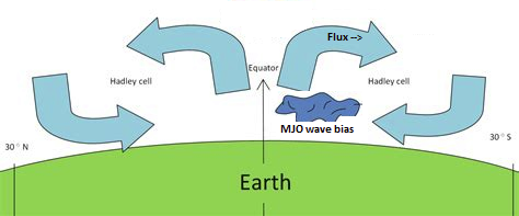
-
December 2021 Obs/Disco...Dreaming of a White-Weenie Xmas
Typhoon Tip replied to 40/70 Benchmark's topic in New England
La Nina and MJO phases late 6 thru 2 are destructive interference -
December 2021 Obs/Disco...Dreaming of a White-Weenie Xmas
Typhoon Tip replied to 40/70 Benchmark's topic in New England
Not a huge fan of this model anyway but that’s a suppressing trend -
December 2021 Obs/Disco...Dreaming of a White-Weenie Xmas
Typhoon Tip replied to 40/70 Benchmark's topic in New England
I know you mean well but I really hate these charts… This is not the icon model run - this is an interpretive algorithm spitting out snow based on who knows what math they use. Goes for all snowfall layouts regardless of model. -
December 2021 Obs/Disco...Dreaming of a White-Weenie Xmas
Typhoon Tip replied to 40/70 Benchmark's topic in New England
Heh. I just read ‘east wind’ in the context fear. Lol i looked at that and thought good, all safe and snug and tucked in for no worries. -
December 2021 Obs/Disco...Dreaming of a White-Weenie Xmas
Typhoon Tip replied to 40/70 Benchmark's topic in New England
Yeah it’s not abundantly clear how much that limits forcing N … but it has to - latent heat flux moves away from the source but does not cross the equatorial asymptote personally I don’t think the MJO … i just suspect that it’s in trouble because of HC anyway. It’s been having trouble coupling, and now it’s S eq based, and south of the eq virtual axes in which the atmospheres of the hemispheres don’t tend to interact The math of all that does not add up to influencing the northern hemisphere… Now if the wave suddenly expands across the equator and starts generating convection on that side … the flux moves away and we’ll see but then again my personal hang up still have to work the HC -
December 2021 Obs/Disco...Dreaming of a White-Weenie Xmas
Typhoon Tip replied to 40/70 Benchmark's topic in New England
The present emerging MJO is momentum biased S of the equator. “Whatever happens in Vegas stays in Vegas” -
December 2021 Obs/Disco...Dreaming of a White-Weenie Xmas
Typhoon Tip replied to 40/70 Benchmark's topic in New England
That images right there is a N ageo wind on the west side of a CF pressed right astride Rt 128 … -
December 2021 Obs/Disco...Dreaming of a White-Weenie Xmas
Typhoon Tip replied to 40/70 Benchmark's topic in New England
Those highs have sped up in guidance like 90% of the times when starting D5 <-- inwards... It'll be interesting if this one bucks that solidly dependable trend - -
December 2021 Obs/Disco...Dreaming of a White-Weenie Xmas
Typhoon Tip replied to 40/70 Benchmark's topic in New England
seems like the models are selling a scenario where we get these Lakes bombs, followed by a low end snow here, rolls right back into a warm up and Lakes bomb... rinse repeat -
December 2021 Obs/Disco...Dreaming of a White-Weenie Xmas
Typhoon Tip replied to 40/70 Benchmark's topic in New England
Man, eastern MN is setting up for a Younger Dryas blizzard with that -28 C air sitting right there and getting sucked into that circulation like that. How about wind gusts to 55 mph, temperature of -15 F, and shattered snow dust down to 20 feet visibility blue dimming -
December 2021 Obs/Disco...Dreaming of a White-Weenie Xmas
Typhoon Tip replied to 40/70 Benchmark's topic in New England
Ha - I didn't' actually tho ... It was a jest to encourage groaning lol. -
December 2021 Obs/Disco...Dreaming of a White-Weenie Xmas
Typhoon Tip replied to 40/70 Benchmark's topic in New England
Just fired up a threat thread ... -
December 2021 Obs/Disco...Dreaming of a White-Weenie Xmas
Typhoon Tip replied to 40/70 Benchmark's topic in New England
That ICON model likes the D5.5 -
December 2021 Obs/Disco...Dreaming of a White-Weenie Xmas
Typhoon Tip replied to 40/70 Benchmark's topic in New England
I've been wondering about that too ... but, the stall in it's track...loop back and rapid decay, is not a full recurve ... I wonder how much of it's flux is really getting into westerlies compared to the idealized model. As an afterthought... Recurving west Pac TC's is typical of either about to, or in, late Phase 6 - early 2 side of the RMM/MJO wave guide. What is interesting, is what Ray and I were just musing. The present MJO is indeed in those phases, but, it's not in the Northern Hemisphere's side of the Equator ( according to document/publication). But, since this Nyotoh isn't 'technically' succeeding in recurving... it's weird - In any case, the reason that is stalling there and not actually succeeding in smearing up on into the westerlies, is because the WPO is out of phase. That's related to the highly coupled circulation mode coming off of Asia from what I'm seeing - which blows big donkey balls...because I believe until that happens, we have to bootleg winter appeal here because the other major telecon players are not really going to be in a hurry until we can get that to break-down and send the roulette wheel rotating around into a different wave # ...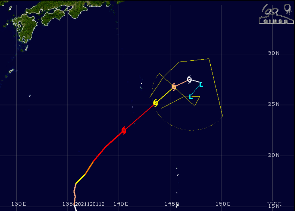
-
December 2021 Obs/Disco...Dreaming of a White-Weenie Xmas
Typhoon Tip replied to 40/70 Benchmark's topic in New England
Just my 2 cents: nothing's changed since the observations posted two day or so ago. The telecon's ( GEFs fwiw - ) are empirically behaving with acceptable error - looks (~) like > 80 some odd % ... which is fine for < D10. That all means it is helping determinism to employ at this time. The MJO ...being south bias of the Equator, probably is less factoring over the next two weeks... ( as an aside, I still believe personally that the MJO's forcing ability on the mid latitudes is being partially absorbed by the HC shit.. but that is secondary/after consideration to what Ray and I was just discussing - ) So, all else being fair and unfair... +AO/+NAO/-PNA ( and it is noted, the individual members are unusually agreeing in magnitude - oy!), ...normally, that would not be the preferred converging telecon signals for winter weather enthusiasts, to put it diplomatically. BUT, I believe this 10 days has to be adjusted due to the fact that the PV is pretty significantly geographically biased over our quatra-hemispheric scope. That's loaded the Can shield with -20 to -30 C 850 mass roughly 2/3rds the size of the contiguous U.S., and is packing the 850 mb thickness gradient right down to 45 N ... The immense velocities above that at 500 mb ...it's all part of the compression, too. The D6 flat wave next week ... First of all, that is remarkable that all operational guidance ( except the UKMET which I have not seen ) are, with this exception of meaningless noise ) essentially handling incredibly fragility with that. The flow leading, around ..., and after it, is is like a flea between two elephant asses terrified for its lift.. It seems the slightest alteration in flow that powerful would have an equally handsome impact on embedded features, so being able to maintain that little weakling is pretty delicate handling there. Interesting. But, that sensitivity works both ways...Despite the cutters ...any one of them can modulate along the polar boundary, and because the gradient is large, smaller adjustment N or S in the track streams ... Lot goin' on folks. -
December 2021 Obs/Disco...Dreaming of a White-Weenie Xmas
Typhoon Tip replied to 40/70 Benchmark's topic in New England
Oh I see - sure ... 'indirectly' -as in...after all physical processes have finished restoring, and the total system state is at rest ( entropy), the HC's scalar dimension is what it is. And what it is or has become rather, bigger than it was in 1980 - Think of it is as 'after the heat has been added to the integral' -
December 2021 Obs/Disco...Dreaming of a White-Weenie Xmas
Typhoon Tip replied to 40/70 Benchmark's topic in New England
separate matter entirely ...


